Edgecliff, New South Wales

Last updated

Edgecliff
Sydney,  New South Wales
Edgecliff Ascham 2.JPG
Ascham School, Edgecliff.
Edgecliff, New South Wales
Map
Population2,499 (SAL 2021) [1]
Postcode(s) 2027
Elevation39 m (128 ft)
Area0.32 km2 (0.1 sq mi)
Location4 km (2 mi) E of Sydney CBD
LGA(s) Municipality of Woollahra
State electorate(s)
Federal division(s) Wentworth
Suburbs around Edgecliff:
Rushcutters Bay Darling Point Double Bay
Darlinghurst Edgecliff Double Bay
Paddington Woollahra Bellevue Hill

Edgecliff is a small suburb in the Eastern Suburbs of Sydney, in the state of New South Wales, Australia. Edgecliff is located 4 kilometres east of the Sydney central business district, in the local government area of the Municipality of Woollahra. The postcode is 2027.

Contents

Edgecliff is surrounded by the suburbs of Double Bay, Woollahra, Paddington, Rushcutters Bay and Darling Point. The property prices are very high because it is close to the city and many homes provide views of Port Jackson (Sydney Harbour).

History

Edgecliff takes its name from its geographic siting. The rocky cliff of the suburb was extensively quarried in the early day of European settlement.

The area was dominated for some time by the Glenrock property, on the north side of New South Head Road. Sir Edward Knox built Fiona in 1864 after having it designed by J. F. Hilly. It has been described as "a Classical Revival two-storey mansion" and was made of sandstone. Other elements of the estate included Glenrock, an Italianate residence designed by David MacBeath and built by John Marks circa 1870. There were also substantial gates of wrought iron and sandstone. The building was demolished when New South Head Road was widened, but the gates survived. Also on the estate was the Dower House, a Victorian Gothic Revival house of sandstone, built some time after 1842 by Whistler Smith. The estate is now the site of Ascham School, and the above items are on the National Estate. [2]

In September 1894, a cable tram service opened, which operated from King Street in the city to Ocean Street in Edgecliff. The powerhouse driving it was located at Rushcutters Bay. Unlike other trams of the era which were driven by steam, the cable ran in a gutter between the tracks. The cars gripped the moving cable to advance and released it to stop. It operated until 1905 when the tram line was electrified. Edgecliff railway station opened in 1979, when the Eastern Suburbs railway line was opened from Central to Bondi Junction. [3]

Heritage listings

Edgecliff has a number of heritage-listed sites, including:

Population

At the 2016 census, there were 2,580 residents in Edgecliff. Most people in Edgecliff came from Anglo-Celtic backgrounds with the most common ancestries being English 24.9%, Australian 15.0%, Irish 10.7% and Scottish 8.1%. 53.3% of people were born in Australia. The next most common country of birth was England at 7.4%. 72.6% of people only spoke English at home. The most common responses for religion were No Religion 33.0% and Catholic 19.1%. With its train station and proximity to the city, there was a high rate of public transport usage. 41.8% of people travelled to work by public transport, compared with the national average of 10.4%. Housing in Edgecliff is high density and most occupied private dwellings were apartments (73.6%). Most of the remaining dwellings were semi-detached (21.6%). [5]

At the 2021 census, the population of Edgecliff was 2,499. [6]

Commercial area

Commercial developments are located on New South Head Road. The Edgecliff Centre is a commercial building with retail space close to the transport services and office space above. Edgecliff Eastpoint is a shopping centre above Edgecliff railway station and below the bus interchange.

Transport

Edgecliff railway station is an underground railway station on the Eastern Suburbs Line of the Sydney Trains network serving Edgecliff. [7] During peak times the station sees trains every 3 to 5 minutes, during off peak times trains arrive around every 8-10 minutes. [8] A bus interchange is located above the railway station. [9]

Schools

Ascham School and one of Sydney Grammar's preparatory schools are on the Edgecliff borders. The Weigall Sports Field and White City, which both belong to Sydney Grammar School, are also located nearby.

Sport and recreation

Since 1908, Edgecliff has been represented in one of Australia's most popular sporting competitions, the National Rugby League, by the Sydney Roosters, officially known as the Eastern Suburbs District Rugby League Football Club.

Related Research Articles

<span class="mw-page-title-main">Rose Bay, New South Wales</span> Suburb of Sydney, New South Wales, Australia

Rose Bay is a harbourside, eastern suburb of Sydney, in the state of New South Wales, Australia. Rose Bay is located seven kilometres east of the Sydney central business district, in the local government areas of Waverley Council and Municipality of Woollahra.

<span class="mw-page-title-main">Bondi Junction</span> Suburb of Sydney, New South Wales, Australia

Bondi Junction is an eastern suburb of Sydney, in the state of New South Wales, Australia. It is 6 kilometres east of the Sydney central business district and is part of the local government area of Waverley.

<span class="mw-page-title-main">Eastern Suburbs & Illawarra Line</span> Rail service in Sydney, New South Wales,Australia

The Eastern Suburbs & Illawarra Line is a commuter railway line on the Sydney Trains network in the eastern and southern suburbs of Sydney. The line was constructed in the 1880s to Wollongong to take advantage of agricultural and mining potentials in the Illawarra area. In March 1926, it became the first railway in New South Wales to run electric train services.

<span class="mw-page-title-main">Eastern Suburbs (Sydney)</span> Region in New South Wales, Australia

The Eastern Suburbs is the eastern metropolitan region of Sydney, New South Wales, Australia.

<span class="mw-page-title-main">Bondi Junction railway station</span> Railway station in Sydney, New South Wales, Australia

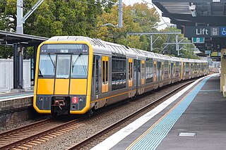
Bondi Junction railway station is located on the Eastern Suburbs line, serving the Sydney suburb of Bondi Junction in the Australian state of New South Wales. It is served by Sydney Trains T4 Eastern Suburbs & Illawarra Line services and NSW TrainLink South Coast Line services.

<span class="mw-page-title-main">Eastern Suburbs railway line</span> Railway line in Sydney, New South Wales

The Eastern Suburbs Railway (ESR) is a commuter railway line in Sydney constructed in the 1970s. It is operated by Sydney Trains and has stations at Martin Place, Kings Cross, Edgecliff and Bondi Junction. In addition, it has dedicated platforms at Town Hall, Central and Redfern stations. All of these stations are underground. The Eastern Suburbs railway connects with the Illawarra line at Erskineville, forming the Eastern Suburbs & Illawarra Line. The line features turnbacks at Central, Martin Place and Bondi Junction. There was also previously a rarely used cross-over at Edgecliff. It operates a service every 3 to 5 minutes during weekday peak hours and 8 to 10 minutes at all other times.

<span class="mw-page-title-main">Double Bay</span> Suburb of Sydney, New South Wales, Australia

Double Bay is a harbourside eastern suburb of Sydney, in the state of New South Wales, Australia 4 kilometres east of the Sydney central business district. It is the administrative centre of the local government area of the Municipality of Woollahra.

<span class="mw-page-title-main">Woollahra</span> Suburb of Sydney, New South Wales, Australia

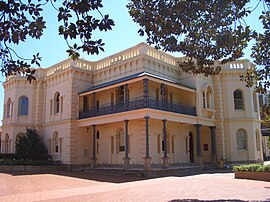
Woollahra is a suburb in the Eastern Suburbs of Sydney, in the state of New South Wales, Australia. Woollahra is located 5 kilometres east of the Sydney central business district, in the local government area of the Municipality of Woollahra. Woollahra is located on the traditional land of the Birrabirragal and Gadigal people of the Eora Nation. The Municipality of Woollahra takes its name from the suburb but its administrative centre is located in Double Bay. Woollahra is famous for its quiet, tree-lined residential streets and village-style shopping centre.

<span class="mw-page-title-main">Paddington, New South Wales</span> Suburb of Sydney, Australia

Paddington is an upscale Eastern Suburb of Sydney, in the state of New South Wales, Australia. Located 3 kilometres (1.9 mi) east of the Sydney central business district, Paddington lies across two local government areas. The portion south of Oxford Street lies within the City of Sydney, while the portion north of Oxford Street lies within the Municipality of Woollahra. It is often colloquially referred to as "Paddo".

<span class="mw-page-title-main">Bellevue Hill, New South Wales</span> Suburb of Sydney, New South Wales, Australia

Bellevue Hill is a harbourside suburb in the eastern suburbs of Sydney, in the state of New South Wales, Australia, located five kilometres east of the Sydney central business district, in the Municipality of Woollahra.

<span class="mw-page-title-main">Watsons Bay</span> Suburb of Sydney, New South Wales, Australia

Watsons Bay is a harbourside, eastern suburb of Sydney, in the state of New South Wales, Australia. Watsons Bay is located 11 km north-east of the Sydney central business district, in the local government area of the Municipality of Woollahra.

<span class="mw-page-title-main">Point Piper</span> Suburb of Sydney, New South Wales, Australia

Point Piper is a small, harbourside eastern suburb of Sydney, in the state of New South Wales, Australia, 6 kilometres (4 mi) east of the Sydney CBD, in the local government area known as the Municipality of Woollahra.

<span class="mw-page-title-main">Edgecliff railway station</span> Railway station in Sydney, New South Wales, Australia

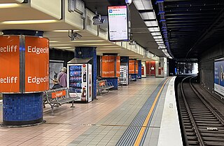
Edgecliff railway station is an underground commuter railway station located on the Eastern Suburbs line, serving the Sydney suburb of Edgecliff. It is served by Sydney Trains T4 Eastern Suburbs & Illawarra Line services and NSW TrainLink South Coast Line services.

<span class="mw-page-title-main">Darling Point</span> Suburb of Sydney, New South Wales, Australia

Darling Point is a harbourside eastern suburb of Sydney, Australia. It is 4 kilometres east of the Sydney central business district and is part of the local government area of Woollahra Council.

<span class="mw-page-title-main">Chatswood West, New South Wales</span> Suburb of Sydney, New South Wales, Australia

Chatswood West is a suburb on the Lower North Shore of Sydney, in the state of New South Wales, Australia. Chatswood West is located 11 kilometres north-west of the Sydney central business district, in the local government areas of the City of Willoughby and City of Ryde. Chatswood is a separate suburb to the east. The locality of Chatswood located west of the Pacific Highway is informally known as West Chatswood, and should not be confused with the separate suburb of Chatswood West, nor should it be confused with the West Chatswood Post Office on Railway Street in the suburb of Chatswood. Chatswood West shares the same postcode as Chatswood which is 2067.

<span class="mw-page-title-main">Sydney Stadium</span> Sporting and entertainment venue in Sydney

The Sydney Stadium was a sporting and entertainment venue in Sydney, New South Wales, which formerly stood on the corner of New South Head Road and Neild Avenue, Rushcutters Bay. Built in 1908, it was demolished in 1970 to make way for the construction of the Eastern Suburbs Railway.

<span class="mw-page-title-main">Electoral district of Vaucluse</span>

Vaucluse is an electoral district of the Legislative Assembly in the Australian state of New South Wales, located east of Sydney CBD in the affluent Eastern Suburbs. It is named after the suburb of Vaucluse.

<span class="mw-page-title-main">New South Head Road</span> Road in Sydney, Australia

New South Head Road is a major road in the Eastern Suburbs of Sydney, linking the inner-eastern suburb of Rushcutters Bay to the southern reaches of the South Head peninsula.

<span class="mw-page-title-main">Woollahra railway station</span> Uncompleted railway station in Sydney, New South Wales, Australia

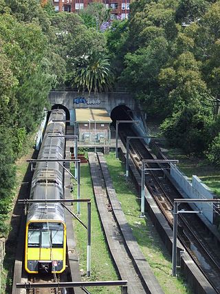
Woollahra railway station was a proposed railway station on Sydney's Eastern Suburbs line. Named after the suburb it was located in, Woollahra railway station would have been built between the present stations of Edgecliff and Bondi Junction. The proposed site of the station currently exists as a cutting off Edgecliff Road. Had this station been completed, it would have been the only above-ground station on the line. Opposition from local residents and costs associated with the construction of the Eastern Suburbs railway prevented the station from being opened.

John Frederick Hilly was a surveyor and architect who designed commercial buildings, churches and houses in mid-nineteenth-century Sydney. He was born in Warwickshire and arrived in Australia in 1839. On 8 January 1842 Hilly married Ellen Morgan at Christ Church St Laurence in Sydney. Hilly Street in Mortlake, New South Wales, is named in his honour. Works attributed to Hilly include:

References

  1. Australian Bureau of Statistics (28 June 2022). "Edgecliff (suburb and locality)". Australian Census 2021 QuickStats. Retrieved 28 June 2022.  OOjs UI icon edit-ltr-progressive.svg
  2. The Heritage of Australia, Macmillan Company of Australia, 1981, ISBN   0-333-33750-6
  3. The Book of Sydney Suburbs, Compiled by Frances Pollon, Angus & Robertson 1990 ISBN   0-207-14495-8
  4. "Fenton and surrounds". New South Wales State Heritage Register . Department of Planning & Environment. H00249. Retrieved 18 May 2018. CC BY icon.svg Text is licensed by State of New South Wales (Department of Planning and Environment) under CC-BY 4.0 licence .
  5. Australian Bureau of Statistics (27 June 2017). "Edgecliff (State Suburb)". 2016 Census QuickStats. Retrieved 2 July 2017. OOjs UI icon edit-ltr-progressive.svg
  6. "2021 Edgecliff, Census All persons QuickStats". Australian Bureau of Statistics. Retrieved 18 August 2022.
  7. "| transportnsw.info". transportnsw.info. Retrieved 20 October 2023.
  8. https://transportnsw.info/documents/timetables/93-T4-Eastern-Suburbs-Illawarra-Line-20220604.pdf
  9. https://transportnsw.info/sites/default/files/document/2017/05/edgecliff_station_accessible.pdf

33°53′00″S151°14′00″E / 33.8833°S 151.2333°E / -33.8833; 151.2333