The Protected areas of New South Wales include both terrestrial and marine protected areas. As of June 2020 there are 225 national parks in New South Wales. A number established since the late 1970s followed campaigns by local residents and environmentalists.
The Kamay Botany Bay National Park is a heritage-listed protected national park that is located in the eastern part of Botany Bay in Sydney, New South Wales, Australia. The 456-hectare (1,130-acre) national park is situated approximately 16 kilometres (9.9 mi) south-east of the Sydney central business district, on the northern and southern headlands of Botany Bay. The northern headland is at La Perouse and the southern headland is at Kurnell.
Budawang National Park is a national park in New South Wales, Australia, located approximately 200 kilometres (120 mi) southwest of Sydney and 25 kilometres (16 mi) north of Batemans Bay. It contains part of the Budawang Mountain Range.

Batemans Bay is a town on the South Coast region of the state of New South Wales, Australia. Batemans Bay is administered by the Eurobodalla Shire council. The town is situated on the shores of an estuary formed where the Clyde River meets the southern Pacific Ocean.

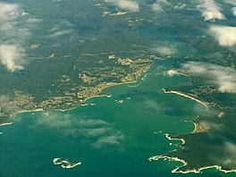
Port Stephens, an open youthful tide-dominated drowned-valley estuary, is a large natural harbour of approximately 134 square kilometres (52 sq mi) located in the Hunter and Mid North Coast regions of New South Wales, Australia.
The Clyde River is an open intermediate tide-dominated drowned valley estuary or perennial river that flows into the Tasman Sea at Batemans Bay, located in the South Coast region of New South Wales, Australia.

The Budawang Range, commonly called The Budawangs, a rugged mountain range within the Budawang National Park and the Morton National Park, are part of a spur off the Great Dividing Range and are located in the South Coast region of New South Wales, Australia.
The Julian Rocks Nguthungulli Nature Reserve is a protected nature reserve that is located on the Julian Rocks in the Northern Rivers region of New South Wales, in Australia. The 4,047-hectare (10,000-acre) reserve comprise two small islands, situated in the Tasman Sea of the South Pacific Ocean, approximately 2.5 kilometres (1.6 mi) northeast of Byron Bay.
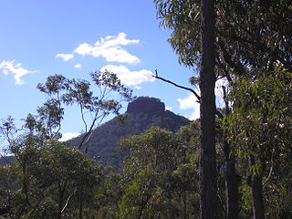
Pigeon House Mountain is a mountain at an elevation of 720 metres (2,360 ft) AHD on the Budawang Range that is situated within the Morton National Park, located on the South Coast region of New South Wales, Australia.

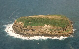
Barunguba / Montague Island is a continental island contained within the Montague Island Nature Reserve, a protected nature reserve that is located offshore from the South Coast region of New South Wales, in eastern Australia. The nearest town located onshore from the 81-hectare (200-acre) reserve and island is Narooma, situated approximately 9 kilometres (5.6 mi) to the northwest.

Narooma is a town in the Australian state of New South Wales on the far south coast. The town is on the Princes Highway, which crosses the Wagonga Inlet to North Narooma. The heritage town of Central Tilba is nearby to the south.

The Yuin nation, also spelt Djuwin, is a group of Australian Aboriginal peoples from the South Coast of New South Wales. All Yuin people share ancestors who spoke, as their first language, one or more of the Yuin language dialects. Sub-groupings of the Yuin people are made on the basis of language and other cultural features; groups include the Brinja or Brinja-Yuin, Budawang, Murramarang, Yuin-Monaro, Djiringanj, Walbunja, and more. They had a close association with the Thaua people.
The Five Islands Nature Reserve is a protected nature reserve located in the Tasman Sea, off the Illawarra east coast of the state of New South Wales, Australia. The 26-hectare (64-acre) reserve comprises five continental islands that are situated between 0.5 and 3.5 kilometres east of Port Kembla. The Five Islands are Flinders Islet, Bass Islet, Martin Islet, Big Island and Rocky Islet.
Bimberamala River, a perennial river of the Clyde River catchment, is located in the Southern Tablelands and the upper ranges of the South Coast regions of New South Wales, Australia.
Buckenbowra River, a perennial river of the Clyde River catchment, is located in the upper ranges of the South Coast region of New South Wales, Australia.
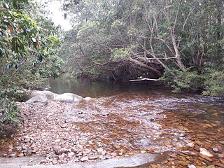
Yadboro River, a perennial river of the Clyde River catchment, is located in the Southern Tablelands and the upper ranges of the South Coast regions of New South Wales, Australia.

The Brush Island is a continental island, contained within the Brush Island Nature Reserve, a protected nature reserve, known as Mit Island in the Dhurga language of the Murramamrang people of the Yuin nation see It is located off the south coast of New South Wales, Australia. The 47-hectare (120-acre) island and reserve is situated within the Tasman Sea, approximately 2 kilometres (1.2 mi) south-east of the coastal village of Bawley Point.
The Bird Island Nature Reserve is a protected nature reserve located near Lake Munmorah on the Central Coast region of New South Wales, Australia. The island is situated 1.4 kilometres (0.87 mi) off the east coast of New South Wales, within the Tasman Sea. The reserve may be seen from the lighthouse at Norah Head.

Narrawallee is a coastal village in the South Coast region of New South Wales, Australia. At the 2016 census, it had a population of 1,241. The village, along with its southern neighbours Mollymook and Mollymook Beach are generally considered part of the Milton-Ulladulla district within the City of Shoalhaven local government area. Narrawallee is predominantly a residential suburb, bordered by a tidal inlet to the north and Matron Porter Drive. The name "Narrawallee" is taken from the creek which flows eastwards from Milton and its estuary on the Tasman Sea and is itself a corruption of the Aboriginal words Nurrawerree or Narra Warra.

Cook Island, formerly Cooks Island, Turtle Island and Joong-urra-narrian, is an island in the Australian state of New South Wales located on the state's north coast about 600 metres (2,000 ft) north-east of Fingal Head and 4 kilometres (2.5 mi) south-east of the town of Tweed Heads.