Green Island (Queensland)

Last updated

Green Island
Native name:
Dabuukji
Green Island QLD.jpg
Green Island jetty
Green Island (Queensland)
Geography
Location Coral Sea
Area0.15 km2 (0.058 sq mi)
Administration
Australia
StateQueensland
LGA Cairns Region
Green Island
Cairns,  Queensland
Green Island (Queensland)
Population20 (2021 census) [1]
 • Density5.7/km2 (15/sq mi)
Postcode(s) 4871
Area3.5 km2 (1.4 sq mi)
Time zone AEST (UTC+10:00)
LGA(s) Cairns Region
State electorate(s) Cairns
Federal division(s) Leichhardt
Suburbs around Green Island:
Coral Sea Coral Sea Coral Sea
Coral Sea Green Island Coral Sea
Coral Sea Coral Sea Coral Sea

Green Island (originally Dabuukji) is a marine island and locality in the Cairns Region, Queensland, Australia. [2] [3] In the 2021 census, Green Island had a population of 20 people. [1]

Contents

Geography

Green Island is coral cay 27 km (17 mi) offshore from Cairns, Queensland, Australia located within the Great Barrier Reef Marine Park World Heritage Area in the Coral Sea. The island is surrounded by coral reef and protected in the Green Island National Park. Most visitors come for the day. A luxury resort with 46 rooms is situated on the island.[ citation needed ]

The island supports a range of vegetation, including dry coastal/beach plants and a vine thicket rain forest. There are no natural freshwater springs on the island so all vegetation relies on rainwater and a small freshwater lens located under the island.

History

Glass bottom boats and a Semi submarine at Green Island Glass bottom boats & Semi sub.JPG
Glass bottom boats and a Semi submarine at Green Island
A Great Barrier Reef ferry, Green Island Great Barrier Reef Ferry.JPG
A Great Barrier Reef ferry, Green Island
Queensland rescue helicopter in Green Island QLD Rescue Helicopter.JPG
Queensland rescue helicopter in Green Island

The island was formed approximately 6,000 years ago by waves depositing sand, coral and other debris onto its coral foundations. [4]

Local Aboriginal language speakers (Roy Banning, Robert Patterson, and Henry Fourmile) advised and confirmed the Gungganyji language group are especially connected with the island. To them it is named Dabuukji. [5] Dabuukji, as a name, may refer to the island having been within local Aboriginal mythology and history a larger island with a freshwater marsh or 'hole' (later a well) at its centre. Alternatively it may be a reference to the story of the turtle which first obtained holes in its nose (nostrils) on this coral cay. It may also be a reference to some aspect of young Gungganyji male initiation rituals reported to have been conducted on this coral cay in times past. [5]

The local Aboriginal people (particularly Dick Moses, speaking Yidinyji) say that in the Dreamtime Dabuukji (Green Island) was approximately four times the size it is now, and that the present coral cay is only the north-east portion of the whole, original island. [6]

Local Aboriginal people have grown up with the understanding the coral cay was a place to be generally avoided, being wunjami, that is, "a place haunted by spirits". [5]

The Queensland Government has gazetted Green Island as the cay's official name, this being the name given it by Lieutenant James Cook on 10 June 1770, either because of the appearance of the coral cay's vegetation, or possibly after Charles Green, who was an astronomer aboard the Endeavour at the time. [2]

The first known non Aboriginal person to reside on the island was fisherman James Seton Veitch Mein in 1857 who established a beche-de-mer smoking station. [7] [8] Coconut palms were planted on the island in 1899 to provide food for shipwrecked sailors.

In April 1873, the Goodwill vessel arrived at Green Island with 3 European crew and 5 Manbarra people press-ganged from Palm Island to collect and process beche de mer. The Aboriginals, including 3 men and 2 women, resented their treatment and killed two of the whites and stole the "Goodwill". The third, Daniel Kelly, escaped to nearby Oyster Quay Island to report the killings to another beche-de-mer fisherman named Philip Garland. [9] The incident was reported to authorities in Cardwell and the Queensland Police Commissioner Seymour ordered Native Police officer Robert Arthur Johnstone to organise a punitive mission.

Johnstone and his troopers sailed to the area in their police boat and found the "Goodwill" abandoned and burnt on a beach in Trinity Bay where the modern-day community of Yarrabah is now located. "The blacks were given a proper warm reception" when Johnstone arrived and after proceeding inland for 3 miles his troopers dispersed another group of local Yidinji people first by firing on them from a distance and then charging amongst them. Johnstone's section then sailed to the mouth of what is now called the Mulgrave River and dispersed "a large mob of blacks" with gunfire. They then sailed further south to the Gladys Inlet (which is now known as the Johnstone River) where a large group of Aboriginals led by a very tall man decorated with pipeclay resisted the troopers' approach. Johnstone punished their "insolence" with gunfire and this leader was one of those killed in the shooting. [10]

In July 1873, four workers, including the owner James Mercer, at another beche-de-mer fishing station on Green Island were killed by press-ganged Manbarra labourers. These Palm Island natives were denied food rations for their work and subsequently killed their overseers in revenge. [11] The record is unclear on whether another punitive mission was organised but the regional newspapers at the time were strong in their contempt for the Manbarra people and hoped for their "final extermination" whether it be by bullets or by rum. [12]

Since the early 20th century, tourism has been the main activity on the island. A guest house was originally built in the 1930s and an underwater observatory was installed in 1954.

In 1970 Queen Elizabeth II, The Duke of Edinburgh and Her Royal Highness Princess Anne toured Australia including Queensland. The Queensland tour began on Sunday 12 April when the royal yacht Britannia entered Moreton Bay at Caloundra, sailing into Newstead Wharf. After visiting Brisbane, Longreach and Mount Isa the Royal Family travelled to Mackay. The royal party had a leisurely cruise to Townsville. According to the formal schedule, the Royal Yacht Britannia arrived off Green Island on the morning of 21 April, after leaving Townsville the day before. The scheduled visit to Green Island was dependent on the weather. All three members of the Royal family were taken by Royal Barge to the Green Island jetty. The visit only lasted 30mins, before Britannia left for Cooktown by 10:15am the same day. [13]

The current resort, Green Island Reef Resort, was opened in 1994. [7]

A seawater desalination plant was commissioned to supply water to the resort in 2001. The plant supplies 55 kL/d of potable water, and returns waste brine to the sea. [14]

Demographics

In the 2016 census, Green Island had a population of 25 people. [15]

In the 2021 census, Green Island had a population of 20 people. [1]

Education

There are no schools on Green Island. The nearest schools are in Cairns. [16] Distance education and boarding schools are other options.

Transport

Commercial charter boats, helicopter and seaplane services all provide transport to the island. [17] The island is reachable by a 45-minute catamaran ride from the mainland city of Cairns.

Green Island panorama.jpg
Panorama of Green Island

See also

Related Research Articles

<span class="mw-page-title-main">Fitzroy Island National Park</span> Protected area in Queensland, Australia

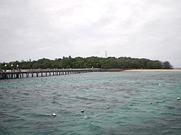
Fitzroy Island National Park is a gazetted protected area covering Fitzroy Island, in Far North Queensland, Queensland, Australia. Fitzroy Island, is a continental island located 22 kilometres (14 mi) east of Cairns on the mainland.

<span class="mw-page-title-main">Green Island National Park</span> Protected area in Queensland, Australia

Green Island National Park is a protected area declared over a small coral cay of Green Island, Cairns Region, Queensland, Australia. It is known to the local Gungganyji Aboriginal peoples as Dabuukji. The Gungganyji people used the island as an initiation ground.

<span class="mw-page-title-main">Lizard Island</span> Protected area in Queensland, Australia

Lizard Island, also known as Jiigurru or Dyiigurra, is an island on the Great Barrier Reef in Queensland, Australia, 1,624-kilometre (1,009 mi) northwest of Brisbane. It is part of the Lizard Island Group that also includes Palfrey Island, and also part of the Lizard Island National Park. Lizard Island is within the locality of Lizard in the Cook Shire. The traditional owners of the Lizard Island group are the Aboriginal Australian clan known as the Dingaal people.

<span class="mw-page-title-main">Cairns</span> City in Queensland, Australia

Cairns is a city in Queensland, Australia, on the tropical north east coast of Far North Queensland. In the 2021 census, Cairns had a population of 153,181 people.

<span class="mw-page-title-main">Hinchinbrook Island</span> Island in Queensland, Australia

Hinchinbrook Island is an island in the Cassowary Coast Region, Queensland, Australia. It lies east of Cardwell and north of Lucinda, separated from the north-eastern coast of Queensland by the narrow Hinchinbrook Channel. Hinchinbrook Island is part of the Great Barrier Reef Marine Park and wholly protected within the Hinchinbrook Island National Park, except for a small and abandoned resort. It is the largest island on the Great Barrier Reef. It is also the largest island national park in Australia.

<span class="mw-page-title-main">Mission Beach, Queensland</span> Town in Queensland, Australia

Mission Beach is a coastal town and locality in the Cassowary Coast Region, Queensland, Australia. In the 2016 census, the locality of Mission Beach had a population of 815 people.

<span class="mw-page-title-main">Palm Island, Queensland</span> Locality consisting of a group of islands in Queensland, Australia

Palm Island is a locality consisting of an island group of 16 islands, split between the Shire of Hinchinbrook and the Aboriginal Shire of Palm Island, in Queensland, Australia. The locality coincides with the geographical entity known as the Palm Island group, also known as the Greater Palm group, originally named the Palm Isles.

<span class="mw-page-title-main">Lady Elliot Island</span> Coral cay located in the Great Barrier Reef

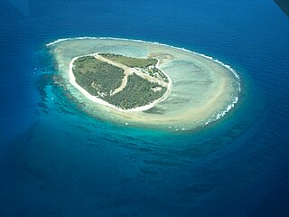
Lady Elliot Island is the southernmost coral cay of the Great Barrier Reef, Australia. The island lies 46 nautical miles north-east of Bundaberg and covers an area of approximately 45 hectares. It is part of the Capricorn and Bunker Group of islands and is owned by the Commonwealth of Australia. The island is home to a small eco resort and an airstrip, which is serviced daily by flights from Bundaberg, Hervey Bay, Brisbane and the Gold Coast.

<span class="mw-page-title-main">Fitzroy Island (Queensland)</span> Island in Queensland, Australia.

Fitzroy Island is a continental island offshore from Cape Grafton, 29 km southeast of Cairns, Queensland, Australia. It is a locality in the Cairns Region. In the 2021 census, Fitzroy Island had a population of 85 people.

<span class="mw-page-title-main">Coconut Island (Queensland)</span> Town in Queensland, Australia

Coconut Island, Poruma Island, or Puruma in the local language, is an island in the Great North East Channel near Cumberland Passage, Torres Strait, Queensland, Australia. One of the Torres Strait Islands, Coconut Island is 130 kilometres (81 mi) northeast of Thursday Island. Administratively, Coconut Island is a town and Poruma Island is the locality within the Shire of Torres.

The history of Cairns in Queensland, Australia, is a transition of a port from a shanty town to a modern city, following an uncertain start because of competition from the newly created neighbouring community of Port Douglas. A succession of major work projects, institution establishments and direct involvement in world enterprise accelerated the settlement's development.

The Manbarra, otherwise known as the Wulgurukaba, are Aboriginal Australian people, and the traditional custodians of the Palm Islands, Magnetic Island, and an area of mainland Queensland to the west of Townsville.

<span class="mw-page-title-main">Palm Cove, Queensland</span> Suburb of Cairns, Queensland, Australia

Palm Cove is a suburb of Cairns in the Cairns Region, Queensland, Australia. In the 2016 census, Palm Cove had a population of 2,059 people.

<span class="mw-page-title-main">Bramble Cay</span> Island in Queensland, Australia

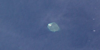
Bramble Cay, also known as Maizab Kaur and Massaramcoer, is a small cay located at the northeastern edge of Australia and the Torres Strait Islands of Queensland and at the northern end of the Great Barrier Reef. Lying around 50 km (31 mi) north of Erub Island in the Gulf of Papua, it is the northernmost point of land of Australia and marks the end of the Great Barrier Reef.

<span class="mw-page-title-main">Coral Sea Reserves Ramsar Site</span> Marine nature reserve off Australia

The Coral Sea Reserves Ramsar Site comprises the 17,289 km2 of oceanic island and reef habitats within the former Coringa-Herald National Nature Reserve and the former Lihou Reef National Nature Reserve in the Australian Coral Sea Islands Territory.

<span class="mw-page-title-main">Mary Watson (pioneer)</span> Australian pioneer and folk heroine

Mary Beatrice Watson, was an Australian folk heroine in Queensland. She died aged 21 on a small island of the northern Great Barrier Reef with her son and a servant, after escaping an attack on Lizard Island, where she had settled with her fisherman husband not long before. Watson's story was subsequently retold in numerous newspaper and folk accounts, including heroic poems, usually with little attention given to the Aboriginal and Chinese aspect of the events.

<span class="mw-page-title-main">Great Palm Island</span>

Great Palm Island, usually known as Palm Island, is the largest island in the Palm Islands group off Northern Queensland, Australia. It is known for its Aboriginal community, the legacy of an Aboriginal reserve, the Palm Island Aboriginal Settlement. The original inhabitants of the island were the Manbarra people, also known as the Wulgurukaba, who were removed to the mainland by the Queensland Government in the 1890s. The island is also sometimes referred to as Bwgcolman, which is the name given to the Aboriginal and Torres Strait Islander people from disparate groups who were deported from many areas of Queensland to the reserve in 1918, and their descendants.

<span class="mw-page-title-main">Robert Arthur Johnstone</span> British colonial police officer

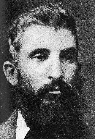
Robert Arthur Johnstone was an officer in the Native Police paramilitary force which operated in the British colony of Queensland. He was stationed at various locations in central and northern Queensland between 1867 and 1880 conducting regular punitive expeditions against clans of Indigenous Australians who resisted colonisation. He also participated in several surveying expeditions in Far North Queensland, including those under the leadership of George Elphinstone Dalrymple.

<span class="mw-page-title-main">Masig Island, Queensland</span> Suburb of Torres Strait Island Region, Queensland, Australia

Masig Island is an island and locality in the Torres Strait Island Region, Queensland, Australia. In the 2021 census, Masig Island had a population of 283 people.

<span class="mw-page-title-main">William Bairstow Ingham</span> (1850–1878) trader and government agent

William Bairstow Ingham was a British colonist who operated a sugarcane plantation in the lower Herbert River region and was an agent for the colonial Government of Queensland during the early years of the British occupation of New Guinea. The town of Ingham in North Queensland is named after him.

References

  1. 1 2 3 Australian Bureau of Statistics (28 June 2022). "Green Island (SAL)". 2021 Census QuickStats. Retrieved 28 February 2023. OOjs UI icon edit-ltr-progressive.svg
  2. 1 2 "Green Island – island (entry 14738)". Queensland Place Names. Queensland Government . Retrieved 21 June 2017.
  3. "Green Island – locality in Cairns Region (entry 48663)". Queensland Place Names. Queensland Government . Retrieved 26 December 2020.
  4. Green Island National Park Archived 29 March 2011 at the Wayback Machine . Department of Environment and Resource Management. Accessed 20 November 2007.
  5. 1 2 3 Martyn, Julie (1993) The History of Green Island: The Place of Spirits Cairns: Bolton Inprint, ISBN   0-646-13270-9
  6. Dixon, R.M.W. (1996) Origin legends and linguistic relationships Oceania, Volume 67 Number 2
  7. 1 2 "Green Island". Sydney Morning Herald. 8 February 2004. Archived from the original on 8 November 2012. Retrieved 28 April 2011.
  8. "Green Island Fact Sheets" (PDF). Green Island Resort. p. 6. Archived (PDF) from the original on 10 March 2018. Retrieved 15 May 2018.
  9. "MURDER OF SEARCHERS FOR BEECHE-DE-MER". Geelong Advertiser . No. 8, 145. Victoria, Australia. 13 May 1873. p. 4. Archived from the original on 18 January 2023. Retrieved 4 August 2018 via National Library of Australia.
  10. Johnstone, Robert Arthur; Johnstone-Need, J. W. (James Walter), 1906- (1984), Spinifex and wattle : reminiscences of pioneering in North Queensland, J.W. Johnstone-Need, ISBN   978-0-9590470-0-4 {{citation}}: CS1 maint: multiple names: authors list (link) CS1 maint: numeric names: authors list (link)
  11. "THE MASSACRE AT GREEN ISLAND". The Brisbane Courier . Vol. XXVIII, no. 4, 965. Queensland, Australia. 28 August 1873. p. 3. Retrieved 4 August 2018 via National Library of Australia.
  12. "TOWNSVILLE". The Queenslander . Vol. VIII, no. 395. Queensland, Australia. 30 August 1873. p. 10. Archived from the original on 9 August 2023. Retrieved 4 August 2018 via National Library of Australia.
  13. CC BY icon-80x15.png This Wikipedia article incorporates text from The state of Queensland welcomes royalty in 1970 - Part 2 The Coastal Tour (6 May 2022) published by the State Library of Queensland under CC BY licence , accessed on 18 May 2022.
  14. Referral detail - Green Island Desalination Plant Archived 10 January 2014 at the Wayback Machine Government of Australia, Department of Environment. Retrieved 7 January 2014.
  15. Australian Bureau of Statistics (27 June 2017). "Green Island (SSC)". 2016 Census QuickStats. Retrieved 20 October 2018. OOjs UI icon edit-ltr-progressive.svg
  16. "Queensland Globe". State of Queensland . Retrieved 3 May 2021.
  17. "About Green Island". Department of Environment and Resource Management. Archived from the original on 23 April 2011. Retrieved 28 April 2011.

Further reading