Queensland is the second largest state in Australia. It contains 472 separate protected areas with a total land area of 69,388 km2 (26,791 sq mi). 223 of these are national parks, which is the highest number of any Australian state or territory, totaling 65,871 km2 (25,433 sq mi). Seven others are Scientific National Parks, totaling 522 km2 (202 sq mi).

Townsville is a city on the north-eastern coast of Queensland, Australia. Townsville is Australia's largest urban centre north of the Sunshine Coast, with a population of 180,820 as of June 2018. Considered the unofficial capital of North Queensland by locals, Townsville hosts a significant number of governmental, community and major business administrative offices for the northern half of the state.

Mackay is a city in the Mackay Region on the eastern or Coral Sea coast of Queensland, Australia. It is located about 970 kilometres (603 mi) north of Brisbane, on the Pioneer River. Mackay is nicknamed the sugar capital of Australia because its region produces more than a third of Australia's sugar. In June 2018, Mackay had a population of 80,148, having decreased slightly at an average annual rate of -0.32% year-on-year over the preceding five years.

The City of Thuringowa was a city and local government area in North Queensland, Australia covering the northern and western parts of what is now Townsville. The suburb of Thuringowa Central is the main business centre in this area.

North Queensland or the Northern Region is the northern part of the Australian state of Queensland that lies just south of Far North Queensland. Queensland is a massive state, larger than many countries, and its tropical northern part has been historically remote and undeveloped, resulting in a distinctive regional character and identity.

Herald Island is in Halifax Bay, south of the Great Palm Island group, northwest of Magnetic Island and northeast of Rollingstone, Queensland, in Australia. The nearest island is Rattlesnake Island. Other nearby islands are Cordelia Rocks, Bramble Island, and Acheron Island.
This article is about Transport in Townsville, Queensland.
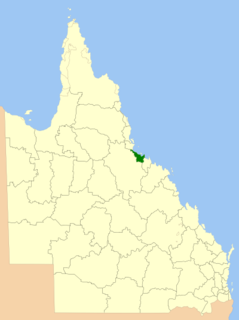
The City of Townsville is an Australian local government area (LGA) located in North Queensland, Australia. It encompasses the city of Townsville, together with the surrounding rural areas, to the south are the communities of Alligator Creek, Woodstock and Reid River, and to the north are Northern Beaches and Paluma, and also included is Magnetic Island. In June 2018 the area had a population of 194,072, and is the 28th-largest LGA in Australia. Townsville is considered to be the unofficial capital of North Queensland.
Rowes Bay is a coastal suburb of the City of Townsville, Queensland, Australia.

This article is a list of the suburbs that used to make up the City of Thuringowa in Queensland, Australia, before the March 2008 amalgamation, which saw the City of Townsville merge with Thuringowa to form the new city of Townsville. Also listed are the former suburbs that became part of Townsville due to other boundary changes that have taken place over the years. The suburbs are listed below in order of postcode and order of years the boundaries were changed:

Bluewater is a town and coastal suburb in the City of Townsville, Queensland, Australia. The coastal town of Bluewater Beach is also within the suburb. At the 2016 census, Bluewater recorded a population of 1,040 people.

Toolakea is a coastal town and suburb in the City of Townsville, Queensland, Australia. In the 2016 census, Toolakea had a population of 205 people.

Yabulu is a town and coastal suburb in the City of Townsville, Queensland, Australia. In the 2016 census, Yabulu had a population of 697 people.

The Bohle River is a river located in North Queensland, Australia.

The geography of Queensland in the north-east of Australia, is varied. It includes tropical islands, sandy beaches, flat river plains that flood after monsoon rains, tracts of rough, elevated terrain, dry deserts, rich agricultural belts and densely populated urban areas.

Rollingstone is a town and coastal locality in the City of Townsville, Queensland, Australia. As of the 2016 census, the population of Rollingstone was 125.

Balgal Beach is a coastal suburb and a beach in the City of Townsville, Queensland, Australia. The town of Balgal is within the locality. In the 2016 census, Balgal Beach had a population of 966 people.
The 1998 Townsville and Thuringowa city floods began on 10 January 1998, the cities of Townsville and Thuringowa were hit by one of the worst floods in the cities' history.

Severe Tropical Cyclone Winifred was the worst tropical cyclone to make landfall in northern Queensland and the first since Althea in 1971 to inflict significant damage on the northeastern coast of Australia. The sixth named storm of the 1985–86 Australian region cyclone season, Winifred originated as a tropical low north of Cairns, Queensland on 27 January 1986. Slowly organizing, the system was recognized as a tropical cyclone after gaining tropical characteristics on 30 January, christened with the name Winifred the same day. Meandering southward, the cyclone began to curve southeastward that evening before suddenly turning toward the coast, southwestward, on 31 January, steadily intensifying in that time. By the time it came ashore near Silkwood, Queensland at 0445 UTC on 1 February, it was producing Category 3-force winds on the Australian tropical cyclone intensity scale and a minimum atmospheric pressure of 957 mbar (28.38 inHg). Weakening as it drifted inland, Winifred persisted as a tropical depression for another five days after landfall before finally dissipating on 5 February.

South Mission Beach is a coastal town and locality in the Cassowary Coast Region, Queensland, Australia. In the 2016 census, South Mission Beach had a population of 932 people.

