
Curtis Island National Park is on Curtis Island, Queensland, Australia, in the Gladstone Region, 474 kilometres (295 mi) northwest of Brisbane and 40 kilometres (25 mi) southeast of Rockhampton.

Moreton Island (Mulgumpin) is an island on the eastern side of Moreton Bay on the coast of South East Queensland, Australia. The Coral Sea lies on the east coast of the island. Moreton Island lies 58 kilometres (36 mi) northeast of the Queensland capital, Brisbane. 98% of the island is contained within a national park and a popular destination for day trippers, four wheel driving, camping, recreational angling and whale watching and a 75-minute ferry ride from Brisbane. It is the third largest sand island in the world. Together with Fraser Island, Moreton Island forms the largest sand structure in the world. It was the traditional country of the Ngugi before settlement.

The Capricorn Coast is a stretch of coastline in Central Queensland, Australia and is part of the Shire of Livingstone.

Cape Moreton is a rocky headland at the north eastern tip of Moreton Island in South East Queensland, Australia. The surrounding area is part of the Moreton Island National Park. Flinders Reef is 5 kilometres (3 mi) north-west of Cape Moreton.

Seventeen Seventy, sometimes inaccurately written as 1770 or Town of 1770, is a coastal town and locality in the Gladstone Region, Queensland, Australia. In the 2021 census, the locality of Seventeen Seventy had a population of 125 people.

Double Island Point is a coastal headland in Queensland, Australia. It is the next headland north of Noosa and is within the Cooloola section of the Great Sandy National Park, at the southern end of Wide Bay. It is approximately 12 km south along the beach from the tourist township of Rainbow Beach.

Booby Island is located 45 km (28 mi) northwest of Muttee Heads at the tip of Cape York Peninsula in Queensland, Australia. This island is in the Torres Strait, 32 km (20 mi) west of Thursday Island and 23 km (14 mi) west of Prince of Wales Island. Booby Island is also known as Ngiangu by the Kaurareg people of the western Torres Strait, its traditional owners, named for the giant Ngiangu who was forced from a neighbouring island It has been called Booby Island by a number of European explorers, including Captain Cook, for the presence of the booby birds.

Keppel Bay is a bay in Central Queensland, Australia, at the mouth of the Fitzroy River on the coast of the Coral Sea.

The islands and reefs of the Capricorn and Bunker Group are situated astride the Tropic of Capricorn at the southern end of the Great Barrier Reef, approximately 80 kilometres east of Gladstone, which is situated on the central coast of the Gladstone Region, Queensland, Australia.

Cooktown is a coastal town and locality in the Shire of Cook, Queensland, Australia. Cooktown is at the mouth of the Endeavour River, on Cape York Peninsula in Far North Queensland where James Cook beached his ship, the Endeavour, for repairs in 1770. Both the town and Mount Cook which rises up behind the town were named after James Cook.

Bustard Head Light is an active lighthouse located on the southeast tip of Bustard Head, a headland, about 20 kilometres (12 mi) northwest of Seventeen Seventy, in the Australian state of Queensland, within the Eurimbula National Park and locality of Eurimbula. Built in 1868, it is the second-oldest lightstation in the state, following Cape Moreton Light, and the first to be built in Queensland after its formation in 1859. It is also one of the first in Australia to be constructed using bolted prefabricated segments of cast iron, and one of only two such lighthouses in Queensland, the other being its sibling, Sandy Cape Light. It serves as the central relay for Dent Island Light, Pine Islet Light and Lady Elliot Island Light and as the radio check post for Cape Capricorn Light, Sandy Cape Light and Double Island Point Light.

Sandy Cape is the most northern point on Fraser Island off the coast of Queensland, Australia. The place was named Sandy Cape for its appearance by James Cook during his 1770 voyage up the eastern coast of Australia aboard the Endeavour. To the south the next two ocean headlands are Waddy Point and Indian Head.
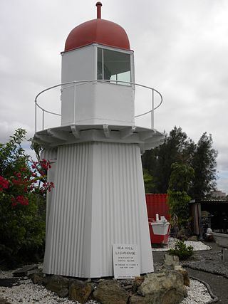
Sea Hill Lighthouse, also known as Sea Hill Point Light or Little Sea Hill Light, is a lighthouse on the northwest point of Curtis Island, Gladstone Region, Queensland, Australia. Its purpose was to mark the east side of the entrance to Keppel Bay, on passage to Fitzroy River and Port Alma. The first lighthouse at the locations was constructed in 1873 or 1876, moved in the 1920s, and is now on display at the Gladstone Maritime Museum. A second lighthouse was constructed in 1895 and its state is unclear.

Cape Capricorn Light is an active heritage-listed lighthouse located on Cape Capricorn, a coastal headland on the northeast point of Curtis Island, in Gladstone Region, Central Queensland, Australia. The lighthouse, constructed in 1964, is the third at this site, following a timber frame lighthouse constructed in 1875 and a concrete lighthouse constructed around 1937. It was added to the Queensland Heritage Register on 31 August 2001.

Point Danger Light, also known as the Captain Cook Memorial Light, is an active lighthouse located on Point Danger, a headland between Coolangatta and Tweed Heads, marking the border between Queensland and New South Wales, Australia. It lays claim to be the first lighthouse in the world to experiment with laser as a light source.

Cape Cleveland Light is an active heritage-listed lighthouse located on the northern tip of Cape Cleveland, a promontory projecting into the Coral Sea west of Cleveland Bay in the locality of Cape Cleveland about 40 kilometres (25 mi) east of Townsville, Queensland, Australia. The lighthouse marks the northern point of the Cape, and the entrance to Cleveland Bay.

Cape Cleveland is a rural locality in the City of Townsville, Queensland, Australia. In the 2016 census Cape Cleveland had a population of 155 people.
Port Curtis is a suburb of Rockhampton in the Rockhampton Region, Queensland, Australia. In the 2016 census, Port Curtis had a population of 281 people.

Curtis Island is a locality in the Gladstone Region, Queensland, Australia. In the 2016 census, Curtis Island had a population of 323 people.

George Poynter Heath was a Royal Navy captain and the first portmaster of Queensland, Australia. It was under his supervision and administration that the 2,086 miles (3,357 km) of coast of Queensland, and its numerous river and creeks, were marked for navigation purposes by means of buoys, beacons, and lights.


