Bankstown

Last updated

Bankstown
Sydney,  New South Wales
Bankstown CBD Aerial view.jpg
Bankstown CBD
Bankstown
Map
Population34,933 (2021 census) [1]
Established1795
Postcode(s) 2200
Elevation29 m (95 ft)
Location19 km (12 mi) south-west of Sydney CBD
LGA(s) City of Canterbury-Bankstown
State electorate(s) Bankstown
Federal division(s)
Suburbs around Bankstown:
Yagoona Chullora Greenacre
Condell Park Bankstown Mount Lewis Punchbowl
Revesby Padstow Punchbowl

Bankstown is a suburb of Sydney, in the state of New South Wales, Australia. It is located 19 kilometres south-west of the Sydney central business district and is part of the Canterbury-Bankstown region. Bankstown is the administrative centre of the City of Canterbury-Bankstown, having previously been the administrative centre of the City of Bankstown prior to the 2016. It is the most populous suburb within the City of Canterbury-Bankstown.

Contents

History

Early history

Before European settlement, Cumberland Plains woodland occupied much of the area. Turpentine ironbark forest covered much of what is now Bankstown. The land was occupied by the Bediagal people. Their land bordered the Dharawal and the Darung people.

In 1795, Matthew Flinders and George Bass explored up the Georges River for about 32 kilometres (20 mi) beyond what had been previously surveyed, and reported favourably to Governor Hunter of the land on its banks. [2] Hunter examined the country himself, and established one of the pioneer colonies there, called Bank's Town, today written as one word: Bankstown. [3] Hunter named the area Bankstown after Sir Joseph Banks, who travelled to Australia with Captain James Cook in 1770. The area of first European settlement along the river has been partially preserved as part of the Mirambeena Regional Park.

In 1826, bushrangers were hanged on the site of the water tower Bankstown Reservoir. [4]

The first town hall and Council Chambers were opened on 22 Oct 1898 by Mayor Ines Peter Miller [5] on the northern side of the Hume Highway (Liverpool Road), near Rookwood Road (site of the Three Swallows Hotel). In June 1918, the council chambers were relocated to a new building in South Terrace (subsequently Old Town Centre Plaza and, since sometime before 2022, Bankstown City Plaza). The building still stands and now has a shopping arcade running through it. Foundation stones from the old Town Halls have been preserved in a display outside the current Council Chambers.

World War II

Bankstown Plaza in 1946 Rwaybridge1946 in Bankstown.jpg
Bankstown Plaza in 1946

In 1939, local residents were made privy to the events of World War II. Conscripted residents were required to report for duty at a drill hall on Canterbury Road, Belmore. Camps were set up in and around Canterbury Racecourse and local parks in the district. Residents with foreign names were sent to internment camps as there was growing suspicion about residents with foreign names. A portion of these folk were Australian citizens who served with the Australian Defence Force during World War I. [6] :14–16

During World War II, Bankstown Airport was established as a key strategic air base to support the war effort. After the arrival of Douglas MacArthur in Australia, control of Bankstown Airport was handed to US Forces, becoming home to US 35th Fighter Squadron and the 41st Pursuit Squadron of the United States Air Force and the United States Army Air Forces who occupied the airport from 1942 to 1944. In 1945 operations became the responsibility of the British Fleet Air Arm, known as HMS Nabberley, [7] until 1946, when it was handed back to the RAAF. [8] [9]

During this period an RAAF unit known as No. 1 Fighter Sector RAAF took control of the Capital Hall in Bankstown. This unit was formed in Bankstown, on 25 February 1942. Their living quarters were located next door and down the road from the hall and the staff were housed in galvanised iron barracks. Operations were handed over to the United States Army Air Corps on 10 April 1942 before they were transferred to a disused railway tunnel at St James railway station in Sydney. The unit was renamed Air Defence Headquarters Sydney (ADHQ) on 21 January 1945 and moved into a three-storey semi-underground purpose built operations and plotting facility at Bankstown, known as the Bankstown Bunker. [10]

World War II began Bankstown's industrial revolution. Few factories or industry of any consequence were located in Bankstown prior to 1945; this was changed dramatically between 1942 and 1954, especially when the Department of Aircraft Production gave approval for aircraft manufacturer Hawker De Havilland to operate a factory at the airport for the production and manufacture of de Havilland Mosquito bombers. There are now over seven-thousand businesses operating within the Bankstown district. [11]

Bankstown Bunker

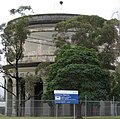
The Bankstown Bunker is a disused RAAF operations facility, located on the corner of Marion and Edgar Street, Bankstown. The specially constructed bunker became an important Royal Australian Air Force headquarters from 1945 until its closure in 1947. [6] :13

The Bankstown Bunker is of similar design to the underground Ops rooms of wartime England, which directed Britain's air defence fighter plane attacks on the invading German Luftwaffe. Entrance to the bunker was obtained through a concrete passageway which was well screened by a grassy slope; a stairway led to a maze of corridors and hallways leading to various sections. [12] [13]

The Bankstown bunker is currently buried under a public park, surrounded by residential dwellings at the northern end of Taylor Street. [14] [15]

Post World War II

After World War II, Bankstown's population increased dramatically. People relocated from the inner-city and incoming migrants came, first as refugees from Europe and towards the end of the 20th century from Asia and the Middle East (especially Vietnamese and Lebanese [16] ) and the rest of the world.

Bankstown Council relocated to its third premises in 1963 when the Civic Centre that was located at the corner of Chapel Road and The Mall was constructed. It included the Council Chambers, or 'Roundhouse'. The current town hall was built in 1973. The administration building which was part of the 1963 premises, was destroyed by fire on 1 July 1997. Council offices relocated to Bankstown Civic Tower (the blue tower) in 1999. On 13 June 2000, Bankstown's now popular Central Park, where the former administration building once stood, was officially declared Paul Keating Park. [6] :13

Heritage

Bankstown has a number of heritage-listed sites, including:

Climate

Bankstown has a humid subtropical climate (Köppen climate classification: Cfa). Like most of Western Sydney, it has warm to hot summers and mild winters. The average summer temperature range is from 17.6 °C (63.7 °F) to 27.8 °C (82.0 °F), although hot north-westerly winds can cause temperatures to rise up to 40 °C (104 °F). On average, Bankstown has 8.8 days per year where the temperature rises above 35 °C (95 °F), [18] as opposed to only 3.0 days for Sydney Observatory Hill. [19] The average winter temperature range is from 5.9 °C (42.6 °F) to 18.0 °C (64.4 °F). On an average of one night a year, the minimum temperature falls below freezing (0 °C). [ citation needed ]

The highest temperature recorded at Bankstown was 46.1 °C (115.0 °F) on 18 January 2013, and the lowest temperature recorded was -4.0 °C (24.8 °F) on 26 July 1968. Bankstown's annual mean rainfall is 869.0mm, slightly less than the Sydney CBD, which is affected more by coastal showers which do not penetrate very far inland.

Climate data for Bankstown Airport AWS (1991−2020 averages, extremes 1968−2022)
MonthJanFebMarAprMayJunJulAugSepOctNovDecYear
Record high °C (°F)47.0
(116.6)
45.3
(113.5)
41.3
(106.3)
36.9
(98.4)
28.8
(83.8)
25.4
(77.7)
26.8
(80.2)
30.2
(86.4)
35.6
(96.1)
39.7
(103.5)
43.1
(109.6)
44.9
(112.8)
47.0
(116.6)
Mean daily maximum °C (°F)29.0
(84.2)
28.2
(82.8)
26.5
(79.7)
24.0
(75.2)
20.8
(69.4)
18.0
(64.4)
17.6
(63.7)
19.3
(66.7)
22.2
(72.0)
24.4
(75.9)
25.8
(78.4)
27.6
(81.7)
23.6
(74.5)
Mean daily minimum °C (°F)18.5
(65.3)
18.3
(64.9)
16.4
(61.5)
12.8
(55.0)
9.3
(48.7)
6.9
(44.4)
5.4
(41.7)
6.0
(42.8)
8.9
(48.0)
12.0
(53.6)
14.7
(58.5)
16.8
(62.2)
12.2
(53.9)
Record low °C (°F)10.4
(50.7)
10.0
(50.0)
7.8
(46.0)
2.4
(36.3)
1.3
(34.3)
−1.9
(28.6)
−4.0
(24.8)
−0.7
(30.7)
0.0
(32.0)
4.8
(40.6)
6.8
(44.2)
6.3
(43.3)
−4.0
(24.8)
Average precipitation mm (inches)87.3
(3.44)
107.3
(4.22)
81.7
(3.22)
67.1
(2.64)
55.1
(2.17)
83.0
(3.27)
44.5
(1.75)
42.7
(1.68)
44.2
(1.74)
53.2
(2.09)
67.8
(2.67)
66.6
(2.62)
800.5
(31.51)
Average precipitation days (≥ 1.0 mm)7.67.48.36.25.86.85.43.95.06.07.47.577.3
Average afternoon relative humidity (%)54575653555552434448525252
Average dew point °C (°F)16.3
(61.3)
17.1
(62.8)
15.2
(59.4)
12.1
(53.8)
9.7
(49.5)
7.5
(45.5)
6.0
(42.8)
5.2
(41.4)
7.4
(45.3)
9.7
(49.5)
12.4
(54.3)
14.4
(57.9)
11.1
(52.0)
Source: Bureau of Meteorology [20]

Commercial area

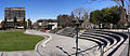
Bankstown's central business district is clustered around Bankstown railway station. The commercial area beside the railway station is known as Bankstown Plaza, while the ethnic diversity of the area has resulted in a host of restaurants, eateries and cafes.

Bankstown Central, formerly known as Centro Bankstown and previously known as Bankstown Square, is a large shopping centre, immediately to the northeast of the railway station. It was first opened in 1966 and has been expanded a number of times.

Bankstown is the seat of major industry including the aviation, engineering and maintenance at Bankstown Airport. Other employers include small industrial operations, the public service and the retail industry. The suburb is affected with unusually high unemployment and is subject to a dedicated income management program specifically targeting the problem. [21]

Bankstown panorama.jpg
Panoramic view of Bankstown CBD in 2008

Transport

Southern entrance to Bankstown railway station Bankstown railway station 20180929 01.jpg
Southern entrance to Bankstown railway station

Bankstown railway station is on the Bankstown line of the Sydney Trains network. The rail line was built to Belmore in 1895 and then extended to Bankstown in 1909. The line was electrified in 1926. In 1928, the line was extended westwards from Bankstown to join the Main Suburban railway at Lidcombe and the Main South line to Liverpool. Bankstown is a major bus interchange for a number of bus services.

The Sydney Metropolitan Airport, more commonly known as Bankstown Airport, was established in 1940 and is constructed on 313 hectares. It has three runways, an extensive taxiway and includes a large business park containing over 170 businesses.

Parks

Major parks within Bankstown include Bankstown City Gardens, Bankstown Oval, Griffith Park, McLeod Reserve and Paul Keating Park.

'Bankstown City Gardens' were opened to the public in 1973. These gardens consist of many unusual types of flora found in Bankstown and the surrounding area. The park consist of different areas, native, tropical, rose garden and Perennial. [22]

'Paul Keating Park' was built on the site of Bankstown Council's former administration building, after it was destroyed by fire on 1 July 1997.

Education

Primary and secondary education

In 1862, the Church of England School was first opened and was commissioned as a public school in 1867. [ citation needed ] Bankstown's first public school was built where McLeod Reserve is currently situated in 1880. In 1882 49 boys and 36 girls were enrolled, and upkeep expenses totalled 219 pounds, eight shillings and 11 pence. The school's first headmaster was Dugald McLeod who taught at the school since its opening until 1912. The site of the well used by Bankstown Public School is today commemorated by a plaque. The school was demolished in 1924 due to the development of North Bankstown School in the same year. [23] The current Bankstown Public School, located on Restwell Street, opened in 1915. It recently celebrated its centenary (1915–2015). Bankstown West Public School, located on the western side of the suburb, opened in 1931. Since then Bankstown has seen the development of several different educational facilities, such as, Al Amanah College, Bankstown Senior College (formerly Bankstown Boys High School 1963–1991), Bankstown Girls High School, Georges River Grammar School, LaSalle Catholic College and St Euphemia College.

Tertiary education

Tertiary institutions located in the suburb include TAFE NSW Bankstown and the Western Sydney University Bankstown City campus. [24]

Sports

Bankstown is represented in the National Rugby League by the Canterbury-Bankstown Bulldogs. Bankstown District Cricket Club, which plays its home games at the Bankstown Oval, represents the suburb in the NSW Premier Cricket competition. Bankstown Bruins, which plays its home games at the Bankstown Basketball Stadium, represents the suburb in the NBL1 East. [25] Bankstown City Lions FC and Canterbury Bankstown FC represents the suburb in the NSW League One competition. [26]

Community facilities

Health

The NSW Government has committed $1.3 billion for a new hospital in the Bankstown CBD. The new Bankstown Hospital will be located at the site of TAFE Bankstown Campus and is expected to open by 2030. [27]

Library

Bankstown Library and Knowledge Centre Bankstown Library and Knowledge Centre May 2019.jpg
Bankstown Library and Knowledge Centre

The Bankstown Central Library [28] has served Bankstown on its present site in The Mall since 1954. Eight years earlier in 1946, Bankstown became the first municipality to adopt the Library Act of 1939 by opening a Children's Library, located at Restwell Street. The Bankstown Central Library was demolished in 1981 to make way for a different facility which opened in 1983. [ citation needed ]

Bankstown's current library, the Bankstown Library and Knowledge Centre was opened in April 2014. The library was designed by FJMT and is located next to the Western Sydney University Bankstown Campus. [29]

Places of worship

Truc Lam and Huyen Quang Temple, Vietnamese Buddhist temples, are located in the suburb. [30]

St Felix de Valois Parish, St Brendan Catholic Church, Bankstown District Uniting Church and St Euphemia Greek Orthodox Church are located in the suburb. [31]

In 1991, the Bankstown Synagogue in Sydney was the subject of an arson attack which destroyed the building. [32] The synagogue was established in 1914. [33] The site was redeveloped and serves as a Uniting Church Aged Care facility. [34]

Demographics

Historical population
YearPop.±%
200125,293    
200626,446+4.6%
201130,572+15.6%
201632,113+5.0%
202134,933+8.8%

In the 2021 census, Bankstown recorded a population of 34,933 people, of which 50.4% were female and 49.6% were male. The median age of the Bankstown population was 34 years, 4 years below the national median of 38. [1]

Bankstown has one of the most ethnically diverse communities in Australia. Bankstown is considered one of the most multicultural areas in the country with over 60 different languages spoken by the people of this suburb. 36.1% of people living in Bankstown were born in Australia. The next top responses for country of birth were 15.6% Vietnam, 6.0% Lebanon, 4.8% China (excludes Taiwan and SARs), 3.2% Pakistan and 3.1% Bangladesh. [1] The most common ancestries in Bankstown were 18.7% Vietnamese, 11.9% Lebanese, 10.8% Chinese, 8.6% Australian and 6.2% English. [1] 18.0% of people spoke only English at home; the next most common languages were 20.3% Vietnamese, 19.3% Arabic, 5.1% Urdu, 4.7% Mandarin and 3.7% Bengali. [1]

The most common responses for religion were 31.1% Islam, 30.8% Christianity (with 16.3% Roman Catholicism), 15.5% No Religion, 11.0% Buddhism and 9.3% not stated. [1]

The median weekly household income in Bankstown was $1,331, and the median weekly family income was $1,436. [1]

Notable people

The following people are residents or former residents of Bankstown:

Related Research Articles

<span class="mw-page-title-main">Beverly Hills, New South Wales</span> Suburb of Sydney, New South Wales, Australia

Beverly Hills is a southern suburb of Sydney, in the state of New South Wales, Australia. Beverly Hills is located 15 kilometres southwest of the Sydney central business district and is part of the St George area and is split between the local government areas of the Georges River Council and the City of Canterbury-Bankstown. The postcode is 2209, which it shares with neighbouring Narwee.

<span class="mw-page-title-main">Richmond, New South Wales</span> Town in New South Wales, Australia


Richmond is a historic town in north-west of Sydney, New South Wales, Australia. Richmond is in local government area of City of Hawkesbury and comes under Sydney Metropolitan area. It is located 20 metres above sea level on the alluvial Hawkesbury River flats, at the foot of the Blue Mountains. It is about 65 km by road from Sydney, 22 km from Penrith, 26 km from Blacktown, 40 km from Parramatta, 78 km from Lithgow and 5 km from Windsor. Richmond Town is now part of Sydney urban area have all amenities including Shopping Malls, Service NSW, Schools, TAFE, University, Post Office, Restaurants, Railway Station, Cafe, Hotel and Supermarkets.

<span class="mw-page-title-main">Greater Western Sydney</span> Region of the metropolitan area of Sydney, Australia

Greater Western Sydney (GWS) is a large region of the metropolitan area of Greater Sydney, New South Wales (NSW), Australia that generally embraces the north-west, south-west, central-west, far western and the Blue Mountains sub-regions within Sydney's metropolitan area and encompasses 11 local government areas: Blacktown, Blue Mountains, Camden, Campbelltown, Cumberland, Fairfield, Hawkesbury, Liverpool, Parramatta, Penrith and Wollondilly. It includes Western Sydney, which has a number of different definitions, although the one consistently used is the region composed of ten local government authorities, most of which are members of the Western Sydney Regional Organisation of Councils (WSROC). The NSW Government's Office of Western Sydney calls the region "Greater Western Sydney".

<span class="mw-page-title-main">Padstow, New South Wales</span> Suburb of City of Canterbury-Bankstown, New South Wales, Australia

Padstow, a suburb of local government area City of Canterbury-Bankstown, is located 21 kilometres south-west of the Sydney central business district, in the state of New South Wales, Australia, and is a part of the South-western Sydney region. Padstow is a mostly residential suburb bounded on the north by Bankstown and on the east by Salt Pan Creek, which is a stream feeding into the Georges River. The M5 South Western Motorway traverses the northern end of the suburb, which is also the location of a number of light industrial facilities.

<span class="mw-page-title-main">Dulwich Hill</span> Suburb of Sydney, New South Wales, Australia

Dulwich Hill is a suburb in the Inner West of Sydney, in the state of New South Wales, Australia. It is 7.5 kilometres south-west of the Sydney central business district, in the local government area of Inner West Council. Dulwich Hill stretches south to the shore of the Cooks River.

<span class="mw-page-title-main">Bass Hill</span> Suburb of Sydney, New South Wales, Australia

Bass Hill, a suburb of local government area City of Canterbury-Bankstown, is located 23 kilometres south-west of the Sydney central business district, in the state of New South Wales, Australia, and is a part of the South-western Sydney region.

<span class="mw-page-title-main">Yagoona, New South Wales</span> Suburb of Sydney, New South Wales, Australia

Yagoona, a suburb of the local government area City of Canterbury-Bankstown, is located 20 kilometres south-west of the Sydney central business district, in the state of New South Wales, Australia. It is a part of the South-western Sydney region. Yagoona is an Aboriginal word meaning 'now' or 'today'. It was the site of the first McDonald's restaurant to open in Australia in December 1971.

<span class="mw-page-title-main">Villawood, New South Wales</span> Suburb of Sydney, New South Wales, Australia

Villawood, a suburb of local government areas City of Canterbury-Bankstown and City of Fairfield, is 27 kilometres west of the Sydney central business district, in the state of New South Wales, Australia.

<span class="mw-page-title-main">Bankstown Airport</span> Australian airport

Bankstown Airport is an airport and business park located in the City of Canterbury-Bankstown, approximately 26 km (16 mi) from the Sydney Central Business District (CBD), Australia, and 17 km (11 mi) west of Sydney Airport. It is situated on 313 ha of land and has three parallel runways, several apron areas, a small passenger terminal and a business park, home to more than 160 businesses. The airport is home to numerous fixed-wing and helicopter flying schools and also caters to charter and private business flights, freight, aeromedical services, recreational flights, aircraft maintenance businesses, private aircraft and emergency services. Bankstown Airport operates 24 hours a day, with limitations placed on night circuit training.

<span class="mw-page-title-main">Regents Park, New South Wales</span> Suburb of Sydney, New South Wales, Australia

Alternate uses: Regents Park (disambiguation)

<span class="mw-page-title-main">Punchbowl, New South Wales</span> Suburb of City of Canterbury-Bankstown, New South Wales, Australia

Punchbowl is a suburb in the south west of Sydney, 17 kilometres (11 mi) west of the Sydney central business district, in the local government area of the City of Canterbury-Bankstown, in the state of New South Wales, Australia. At the 2016 census, Punchbowl had a population of 20,236.

Picnic Point, a suburb of local government area City of Canterbury-Bankstown, is 23 kilometres south-west of the Sydney central business district, in the state of New South Wales, Australia. It is a part of South-western Sydney region. Picnic Point is a residential suburb on the northern bank of the Georges River. Located within Picnic Point is Yeramba Lagoon which is the largest tract of National Park within the Canterbury – Bankstown Council, it is home to numerous species of native fauna and flora.

<span class="mw-page-title-main">Chester Hill</span> City in New South Wales, Australia

Chester Hill, a suburb of Cumberland Council local government area, is located 25 kilometres west of the Sydney central business district, in the state of New South Wales, Australia, and is part of Western Sydney, Chester Hill shares the postcode of 2162 with the neighbouring suburb of Sefton.

<span class="mw-page-title-main">Chullora</span> Suburb of City of Canterbury-Bankstown, New South Wales, Australia

Chullora, a suburb in the City of Canterbury-Bankstown local government area, is located 15 kilometres west of the Sydney central business district, in the state of New South Wales, Australia. It is part of the Greater Western Sydney region. The suburb is entirely industrial and commercial, and in the 2021 census recorded a population of 14.

<span class="mw-page-title-main">Condell Park</span> Suburb of Sydney, New South Wales, Australia

Condell Park, a suburb of local government area City of Canterbury-Bankstown, is 21 kilometres south-west of the Sydney central business district, in the state of New South Wales, Australia. It is a part of the Canterbury Bankstown region, and within the Inner South West area categorised by the Australian Bureau of Statistics. The postcode of Condell Park is 2200, which is shared with Bankstown and Bankstown Aerodrome.

<span class="mw-page-title-main">Campsie, New South Wales</span> Suburb of Sydney, New South Wales, Australia

Campsie is a suburb in the state of New South Wales, Australia. Campsie is 11 kilometres south west of the Sydney central business district, on the southern bank of the Cooks River. Campsie is one of the administrative centres of the City of Canterbury-Bankstown.

<span class="mw-page-title-main">Croydon Park, New South Wales</span> Suburb of Sydney, New South Wales, Australia

Croydon Park is a suburb in the Inner West of Sydney, in the state of New South Wales, Australia. Croydon Park is 10 kilometres south-west of the Sydney central business district and is divided between the local government areas of the City of Canterbury-Bankstown, Municipality of Burwood and Inner West Council. Croydon is a separate suburb, to the north.

<span class="mw-page-title-main">Bankstown Bunker</span> Historic site in New South Wales, Australia

Bankstown Bunker, formerly known as Air Defence Headquarters Sydney, is a heritage-listed defunct Royal Australian Air Force (RAAF) operations facility, located on the corner of Marion and Edgar Street, in Condell Park, New South Wales, Australia. It was designed by the Allied Works Council and built from 1943 to 1944 by Stuart Bros Pty Ltd of Sydney. It is also known as Air Defence Headquarters Ruin Sydney (former), No. 1 Fighter Section Headquarters, 1FSHQ, Bankstown Bunker and RAAF No. 1 Installation Bankstown; No. 101 Fighter Sector. It was added to the New South Wales State Heritage Register on 18 November 2011.

<span class="mw-page-title-main">Canterbury-Bankstown</span> Region in New South Wales, Australia

Canterbury-Bankstown is a customary region of Sydney, Australia, in Inner South-Western Sydney. The region is located to the north of the St George region and to the south of the Inner West region. The suburbs of the Canterbury-Bankstown region are not specific to the local government area of the City of Canterbury-Bankstown, but includes many of them. The Bankstown railway line serves many of the suburbs in this region.

<span class="mw-page-title-main">City of Canterbury-Bankstown</span> Local government area in New South Wales, Australia

Canterbury-Bankstown Council, trading as the City of Canterbury Bankstown, is a local government area in the Canterbury-Bankstown region of Sydney, New South Wales, Australia. The council was formed on 12 May 2016 from a merger of the City of Canterbury and the City of Bankstown, after a review of local government areas by the NSW Government.

References

  1. 1 2 3 4 5 6 7 Australian Bureau of Statistics (28 June 2022). "Bankstown (State Suburb)". 2021 Census QuickStats. Retrieved 5 July 2022. OOjs UI icon edit-ltr-progressive.svg
  2. A Voyage to Terra Australis by Matthew Flinders at Project Gutenberg
  3. The Life of Captain Matthew Flinders, by Ernest Scott at Project Gutenberg
  4. Rosen, Sue (1996). Bankstown, a Sense of Identity.
  5. Cumberland Argus and Fruitgrowers Advocate (Parramatta), Wednesday 2 November 1898, page 6
  6. 1 2 3 Maltby, Kathy; Rosen, Sue. From Settlement to City: Bankstown: Sense of Identity. Bankstown: Bankstown City Council.
  7. "Index of Fleet Air Arm Air Stations in the Commonwealth 1939–1945". Fleetairarmarchive.net. 16 July 2013. Archived from the original on 19 September 2008.{{cite web}}: CS1 maint: unfit URL (link)
  8. You will have to do you own record search for this info (Type in Stacey Street for the key words. For the date type in 1940–1950 and press enter)
  9. A Pictorial History of Canterbury Bankstown. by Joan Lawrence, Brian Madden and Les Muir, Page 89,(Alexandria: Kingsclear Books 1999. Printed by Australian Print Group.) Retrieved on 13 August 2007.
  10. No. 1 Fighter Sector Headquarters RAAF, later known as No. 101 Fighter Control Unit RAAF
  11. About Bankstown Council Archived 29 August 2007 at archive.today
  12. (information supplied by R. Eyers VAOC worker)
  13. Teenagers raid bunker. BunkerBoyz.org. Archived from the original on 29 August 2007. Retrieved 2 February 2010.
  14. Veitch, Alen (24 June 1971). "The Bankstown Bunker". Australian Post.
  15. Images of the Bankstown Bunker located in Condell Park. Archived 16 September 2006 at the Wayback Machine
  16. Beech, James (20 October 2015). "From the Irish and English in the late 18th century, to Lebanese and Vietnamese in recent years - Bankstown has always been a hub for migrants". Daily Telegraph . Australia. Retrieved 18 February 2019.
  17. "Bankstown Reservoir (Elevated)". New South Wales State Heritage Register . Department of Planning & Environment. H01316. Retrieved 18 May 2018. CC BY icon.svg Text is licensed by State of New South Wales (Department of Planning and Environment) under CC-BY 4.0 licence .
  18. "Climate statistics for Bankstown Airport". Bureau of Meteorology . Retrieved 21 February 2015.
  19. "Climate statistics for Sydney Observatory Hill". Bureau of Meteorology . Retrieved 21 February 2015.
  20. "Climate statistics for Bankstown Airport". Bureau of Meteorology . Retrieved 13 April 2013.
  21. Archived 27 March 2012 at the Wayback Machine
  22. File:2007 0808klklk0001.JPG – Wikimedia Commons. Commons.wikimedia.org. Retrieved on 16 July 2013.
  23. File:First public school in bankstown sign.jpg – Wikipedia, the free encyclopedia. En.wikipedia.org. Retrieved on 16 July 2013.
  24. "Bankstown City Campus". Western Sydney University. Retrieved 5 July 2022.
  25. "Bruins History". Bankstown Basketball Association. Retrieved 12 July 2022.
  26. "Bankstown City FC abuzz with their own Matildas star". Football NSW. 5 June 2019. Retrieved 5 July 2022.
  27. "Bankstown CBD announced as location for new hospital". NSW Health. 11 December 2023. Retrieved 1 March 2024.
  28. Archived 19 May 2009 at the Library of Congress Web Archives
  29. "Bankstown Library and Knowledge Centre". Australian Design Review. 31 October 2014. Retrieved 7 October 2021.
  30. "THÀNH VIÊN GIÁO HỘI". The Unified Vietnamese Buddhist Congregation of Australia - New Zealand. Retrieved 14 July 2021.
  31. Simos, Andriana (16 November 2020). "St Euphemia College's Year 12 cohort given touching graduation ceremony". The Greek Herald. Retrieved 5 July 2022.
  32. "Fire at Synagogue in Sydney is Fourth Arson in Six Weeks." Jewish Telegraphic Agency. 7 Mar 1991. Accessed 4 Mar 2024.
  33. Consecration of new synagogue at Bankstown. The Hebrew Standard. 8 April 1914. Accessed 5 March 2024.
  34. "Jewish Martyrs War Memorial Synagogue, Meredith Street Bankstown." Canterbury Bankstown Library and Knowledge Centres. Accessed 19 Mar 2024.
  35. "Reliving the golden days of radio in Australia". The Canberra Times . Australian Capital Territory, Australia. 20 January 1990. p. 20. Retrieved 12 January 2020 via Trove.
  36. Carter, Brittany (9 November 2021). "How the pandemic helped cricketer Ashleigh Gardner build a deeper connection with her Indigenous identity". ABC. Retrieved 27 June 2023.
  37. "Andrew Scipione - the top cop with a big heart". News Pty Ltd. Retrieved 4 December 2019.(Subscription required.)

Further reading

33°55′05″S151°02′06″E / 33.91806°S 151.03500°E / -33.91806; 151.03500