Rockdale, New South Wales

Last updated

Rockdale
Sydney,  New South Wales
Rockdale Bicentennial Park 1.JPG
Bicentennial Park, Rockdale
Rockdale, New South Wales
Map
Population15,534 (2016 census) [1]
 • Density6,470/km2 (16,800/sq mi)
Established1887
Postcode(s) 2216
Elevation20 m (66 ft)
Area2.4 km2 (0.9 sq mi)
Location13 km (8 mi) south of Sydney CBD
LGA(s) Bayside Council
State electorate(s) Rockdale
Federal division(s) Barton
Suburbs around Rockdale:
Arncliffe Banksia Kyeemagh
Bexley Rockdale Brighton-Le-Sands
Bexley Kogarah Monterey

Rockdale is a suburb in southern Sydney, in the state of New South Wales, Australia. Rockdale is located 13 kilometres south of the Sydney central business district and is part of the St George area. Rockdale is one of the administrative centres for the local government area of the Bayside Council. Since 1985 Rockdale has been a twinned city with Bitola, in the Republic of Macedonia.

Contents

History

Rockdale was known by Europeans as Frog Hollow, then White Gum Flat and later as West Botany. The name Rockdale was suggested in 1878 by the first postmistress, Mrs Mary Ann Geeves. The name for the district gained more credence when the local railway station on the new Illawarra rail line, opened on 15 October 1884, was also given the name Rockdale. [2] The West Botany Municipality, declared on 13 January 1871 with two wards, West Botany and Arncliffe, was renamed "The Municipality of Rockdale" on 17 May 1888. [2]

A council chambers for the West Botany Municipality was built in 1872 on Rocky Point Road, Arncliffe and was used until 1888 when a new building was erected on the site of the present Rockdale Town Hall, [2] which was then demolished and rebuilt in 1940 [3]

Rockdale Town Hall and Library Rockdale Town Hall and Library.jpg
Rockdale Town Hall and Library

There was a suggestion that the area become the Municipality of Scarborough but the name Rockdale was suggested by pioneer Mary Ann Geeves, postmistress and tollgate keeper and was officially adopted in 1887. Her husband, Yeoman Geeves, was a ganger on the construction of Rocky Point Road and the demolition of Cobbler's Hill (later called Arncliffe Hill). The Geeves family, including eldest son Frederick lived on the corner of today's Princes Highway and Tramway Arcade. Their general store adjoined the cottage and operated the first post office between Arncliffe and Kogarah in 1882. Residential development began with the opening of the railway in 1884. Perhaps the most significant property developer during the 1880s was Frederick Jamison Gibbes (1839–1888), a Member of Parliament, who is commemorated by Gibbes Street in Banksia. Until 1949, an electric tramway operated between Rockdale Station down Bay Street to Brighton-Le-Sands. In 1948, Rockdale and Bexley councils amalgamated as Rockdale Municipal Council. The City of Rockdale was declared in 1995 [4] and it was merged with City of Botany Bay in 2016 to become Bayside Council.

Heritage listings

Rockdale has a number of heritage-listed sites, including:

Commercial areas

Cafe Culture, King Street RockdaleCafes.jpg
Café Culture, King Street

Rockdale has a mixture of residential, commercial and light industrial areas. The main shopping strip runs along the Princes Highway, on the eastern side of Rockdale railway station. The commercial centre spreads out into surrounding streets and on the western side of the railway line. King Street has developed into a cosy strip of cafes and grocery shops. Commercial developments run along the length of the parts of Bay Street and West Botany Street. The light industrial areas are located around West Botany Street.

Rockdale Plaza is shopping centre located on Princes Highway in the southern part of the suburb. [9]

Rockdale Town Hall and the St George Tavern are examples of some of the Art Deco architecture in the area. The Town Hall was built in 1940 to a design by local resident and architect Douglas Gardiner. [10]

Population

According to the 2016 Australian Bureau of Statistics Census of Population, there were 15,534 people usually resident in Rockdale. 31.0% of people were born in Australia. The next most common countries of birth were Nepal 12.8%, China 9.7%, Bangladesh 5.0%, Macedonia 3.8% and Philippines 3.4%. 25.1% of people spoke only English at home. Other languages spoken at home included Nepali 13.4%, Mandarin 8.3%, Macedonian 5.8%, Bengali 5.1% and Cantonese 4.8%. The most common responses for religious affiliation were No Religion 20.1%, Catholic 17.1%, Hinduism 14.6%, Islam 10.5% and Eastern Orthodox 10.2%. [1]

Politics

Transport

Last run to Rockdale from Brighton-Le-Sands Last run to rockdale 1949.jpg
Last run to Rockdale from Brighton-Le-Sands

The Princes Highway is the main road through Rockdale. West Botany Street, to the east, runs parallel to Princes Highway. Bay Street links Rockdale to General Holmes Drive at Brighton-le-Sands. Rockdale railway station is on the Illawarra line of the Sydney Trains network. Rockdale is a major bus interchange for Transit Systems buses, which operates services to Miranda, Brighton-Le-Sands, Burwood and Mascot and Transdev which operates to Hurstville.

Rockdale to Brighton-Le-Sands tram line

This line opened as a private steam tramway in 1885. It was electrified in 1900, and moved into government ownership in 1914. The line connected with the trains at Rockdale station, then passed down Bay Street to Brighton-Le-Sands. The line was single track throughout, with a passing loop at each end. The line closed in 1949 and was replaced by a bus service. A small depot in Rockdale maintained the cars.

Rockdale is also serviced by St George Community Transport, a HACC funded transport serviced for the Frail Aged, people with disability and their carers. [11]

Related Research Articles

<span class="mw-page-title-main">Arncliffe, New South Wales</span> Suburb of Sydney, New South Wales, Australia

Arncliffe is a suburb in southern Sydney, in the state of New South Wales, Australia. Arncliffe is located 11 kilometres south of the Sydney central business district, in the local government area of the Bayside Council.

<span class="mw-page-title-main">Brighton-Le-Sands, New South Wales</span> Suburb of Sydney, New South Wales, Australia

Brighton Le Sands, is a suburb in southern Sydney, in the state of New South Wales, Australia. Brighton Le Sands is located 13 kilometres south of the Sydney central business district, on the western shore of Botany Bay. Brighton Le Sands is in the local government area of the Bayside Council and is part of the St George area.

<span class="mw-page-title-main">Kogarah, New South Wales</span> Suburb of Sydney, New South Wales, Australia

Kogarah is a suburb of Southern Sydney, in the state of New South Wales, Australia. Kogarah is located 14 kilometres south-west of the Sydney central business district and is considered to be the centre of the St George area.

<span class="mw-page-title-main">St George, Sydney</span> Region in New South Wales, Australia

The St George region of Sydney is part of the southern suburbs of Sydney, in the state of New South Wales, Australia. The area includes all the suburbs in the local government area of Georges River Council and the part of Bayside Council which was Rockdale City prior to 2016. The eastern boundary of the district is Lady Robinson Beach on Botany Bay. The name "St George" derives from the cadastral Parish of St George, and the area was later covered by the St George County Council, the electricity supplier for the councils in this region.

<span class="mw-page-title-main">Tempe, New South Wales</span> Suburb of Sydney, New South Wales, Australia

Tempe is a suburb in the Inner West of Sydney, in the state of New South Wales, Australia. Tempe is located 9 kilometres south of the Sydney central business district in the local government area of Inner West Council.

<span class="mw-page-title-main">Arncliffe railway station</span> Railway station in Sydney, New South Wales, Australia

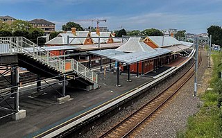
Arncliffe railway station is a heritage-listed railway station located on the Illawarra line, serving the Sydney suburb of Arncliffe in Bayside Council. It is served by Sydney Trains T4 line services. It was added to the New South Wales State Heritage Register on 2 April 1999.

<span class="mw-page-title-main">Rockdale railway station</span> Railway station in Sydney, New South Wales, Australia

Rockdale railway station is a heritage-listed railway station located on the Illawarra line, serving the Sydney suburb of Rockdale in Bayside Council. It is served by Sydney Trains T4 line services. It was added to the New South Wales State Heritage Register on 2 April 1999.

<span class="mw-page-title-main">City of Rockdale</span> Local government area in New South Wales, Australia

The City of Rockdale was a local government area in southern and St George regions of Sydney, in the state of New South Wales, Australia. The city centre was located 12 kilometres (7.5 mi) south of the Sydney central business district, on the western shores of Botany Bay. First proclaimed on 13 January 1871, Rockdale was formerly known as the Municipality of West Botany until 1887 and the Municipality of Rockdale before being proclaimed as a City in 1995. Rockdale was amalgamated with the neighbouring City of Botany Bay on 9 September 2016 to form the new municipality of Bayside Council.

<span class="mw-page-title-main">Turrella, New South Wales</span> Suburb of Sydney, New South Wales, Australia

Turrella is a suburb in southern Sydney, in the state of New South Wales, Australia. Turrella is located 10 km south of the Sydney central business district on the southern bank of Wolli Creek in the local government area of Bayside Council.

<span class="mw-page-title-main">Kyeemagh</span> Suburb of Sydney, New South Wales, Australia

Kyeemagh is a suburb in southern Sydney, in the state of New South Wales, Australia. It is 12 kilometres south of the Sydney central business district, on the western shore of Botany Bay. Kyeemagh is in the local government area of the Bayside Council and is part of the St George area.

<span class="mw-page-title-main">Wolli Creek, New South Wales</span> Suburb of Sydney, New South Wales, Australia

Wolli Creek is a suburb in southern Sydney, in the state of New South Wales, Australia. It sits beside the Wolli Creek and Cooks River waterways. Wolli Creek is situated between the suburbs of Arncliffe and Tempe, 10 kilometres south of the Sydney central business district and is part of the St George area. Wolli Creek is in the local government area of Bayside Council.

<span class="mw-page-title-main">Banksia, New South Wales</span> Suburb of Sydney, New South Wales, Australia

Banksia is a suburb in southern Sydney, in the state of New South Wales, Australia. Banksia is located 12 kilometres south of the Sydney central business district, in the local government area of the Bayside Council and is part of the St George area.

<span class="mw-page-title-main">Bexley, New South Wales</span> Suburb of Sydney, New South Wales, Australia

Bexley is a suburb in southern Sydney, in the state of New South Wales, Australia. Bexley is located 14 kilometres (8.7 mi) south-west of the Sydney central business district, in the local government area of the Bayside Council and is part of the St George area.

<span class="mw-page-title-main">Electoral district of Rockdale</span>

Rockdale is an electoral district of the Legislative Assembly in the Australian state of New South Wales. Suburbs within the electoral district include Arncliffe, Banksia, Bardwell Park, Bardwell Valley, Beverley Park, Bexley, Bexley North, Brighton-Le-Sands, Dolls Point, Kogarah, Kogarah Bay, New South Wales, Kyeemagh, Monterey, Ramsgate, Ramsgate Beach, Rockdale, Sandrigham, Sans Souci, Turella and Wolli Creek.

<span class="mw-page-title-main">Lady Robinsons Beach</span>

Lady Robinsons Beach is the stretch of beach between the mouth of the Cooks River and the mouth of Georges River on the western shore of Botany Bay in Sydney, New South Wales, Australia. Originally known as Seven Mile Beach, it was renamed after the wife of the then Governor, Sir Hercules Robinson. Isolated settlements separated from the beach by sand dunes were also given the name of Lady Robinson's Beach as their postal address.

Brighton-le-Sands: a brief history to 31 January 1971, prior to the name change for the suburb

<span class="mw-page-title-main">Bayside Council</span> Local government area in New South Wales, Australia

Bayside Council is a local government in New South Wales, Australia. It is located in Sydney, around part of Botany Bay, 7 kilometres (4.3 mi) to 12 kilometres (7.5 mi) south of the CBD. It includes suburbs of South Sydney and the St George area separated by the Cooks River. It comprises an area of 50 square kilometres (19 sq mi) and as at the 2016 census had a population of 156,058.

The Cooks River cycleway, also called the Bay to Bay Shared Pathway, is a 30-kilometre-long (19 mi) shared use path for cyclists and pedestrians in the Inner West of Sydney, New South Wales, Australia. The north-western terminus of the cycleway is in Settlers' Park, Ryde, from where it proceeds south, crossing the Parramatta River and skirting Homebush Bay to the Cooks River, from where it generally follows the course of the river south and east to the south-eastern terminus on Botany Bay at Kyeemagh. The alternative name "Bay to Bay" or "B2B" path refers to Homebush Bay and Botany Bay. The path connects a series of parklands in the City of Ryde and the Municipality of Strathfield, as well as the riverside green spaces along the course of the Cooks River.

<span class="mw-page-title-main">Lydham Hall</span> Historic site in New South Wales, Australia

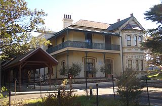
Lydham Hall is a State heritage-listed former rural residence at 18 Lydham Avenue, Rockdale in New South Wales, Australia. It is constructed from stone quarried locally and stands on the highest point of land between the Cooks River and the Georges Rivers. The Street previously known as Joseph Street was named Lydham Avenue in 1917 at the request of one of the neighbouring property owners. In 1970, Lydham Hall was purchased by the Rockdale Municipal Council. Since the 2016 Council amalgamation, the property is owned by the Bayside Council. Initially, the Permanent Conservation Order No 477 in pursuance of section 44 of the Heritage Act 1977, was applied to the property since 20th August, 1986. In 1999, it was included into the New South Wales State Heritage Register since its implementation. Lydham Hall is now a museum open to the public with a collection of furniture and objects dated within the period 1860 to 1920.

Arncliffe Market Gardens is a heritage-listed market garden at 212 West Botany Street, Banksia, Bayside Council, New South Wales, Australia. It was established from 1892 by Sun Kuong-War. It is also known as West Botany Street Market Gardens, Rockdale Market Gardens and Chinese Market Gardens. It was added to the New South Wales State Heritage Register on 2 April 1999.

References

  1. 1 2 Australian Bureau of Statistics (27 June 2017). "Rockdale (State Suburb)". 2016 Census QuickStats. Retrieved 20 October 2018. OOjs UI icon edit-ltr-progressive.svg CC-BY icon.svg Material was copied from this source, which is available under a Creative Commons Attribution 4.0 International License.
  2. 1 2 3 A Century of Progress: Rockdale 1871-1971 compiled by Rockdale Municipal Council, produced by Paul Horne and printed by Posters Pty, Ltd, Lane Cove
  3. The Book of Sydney Suburbs, Page 223, Compiled by Frances Pollon, Angus & Robertson Publishers, 1990, Published in Australia ISBN   0-207-14495-8, page 223
  4. Lawrence, Joan (1996). Pictorial Memories St. George: Rockdale, Kogarah, Hurstville. Australia: Kingsclear Books. ISBN   0-908272-45-6.
  5. "Rockdale Railway Station Group". New South Wales State Heritage Register . Office of Environment & Heritage. H01238. Retrieved 18 May 2018.
  6. "Lydham Hall". New South Wales State Heritage Register . Office of Environment & Heritage. H00477. Retrieved 18 May 2018.
  7. "Kyeemagh Market Gardens". New South Wales State Heritage Register . Office of Environment & Heritage. H01393. Retrieved 18 May 2018.
  8. "Wilsons Farm House". New South Wales State Heritage Register . Office of Environment & Heritage. H00487. Retrieved 18 May 2018.
  9. "About Us | Rockdale Plaza". rockdaleplaza.com.au. Retrieved 28 November 2020.
  10. "BUILDING AND CONSTRUCTION". The Sydney Morning Herald . National Library of Australia. 16 January 1940. p. 7. Retrieved 10 July 2012.
  11. "Home". stgct.org.au.

Coordinates: 33°57′12″S151°08′24″E / 33.95329°S 151.13996°E / -33.95329; 151.13996