Botany, New South Wales

Last updated

Botany
Sydney,  New South Wales
Botany School of Arts.JPG
Botany School of Arts (1867), Botany Road
Botany, New South Wales
Map
Population12,960 (2021 census) [1]
 • Density1,066.6/km2 (2,762/sq mi)
Postcode(s) 2019
Elevation6 m (20 ft)
Area7 km2 (2.7 sq mi)
Location11 km (7 mi) south of Sydney CBD
LGA(s) Bayside Council
State electorate(s) Maroubra
Federal division(s) Kingsford Smith
Suburbs around Botany:
Sydney Airport Mascot Pagewood
Sydney Airport Botany Banksmeadow
Botany Bay Botany Bay Port Botany

Botany is a suburb in the Inner Southern Suburbs of Sydney, in the state of New South Wales, Australia. Botany is located 11 kilometres south of the Sydney central business district and is part of the Bayside Council. [2]

Contents

Botany sits on the northern shore of Botany Bay, east of Sydney Airport, adjacent to the suburbs of Mascot, Banksmeadow, Pagewood and Port Botany.

History

Real estate map of Botany, 1907 Botany real estate map, 1907.tif
Real estate map of Botany, 1907

Botany Bay, to the south, is where Captain James Cook first landed on 29 April 1770, when navigating his way around Australia on his ship, the Endeavour. The ship's English botanist Joseph Banks and Swedish assistant botanist Daniel Solander, spent several days on shore collecting vast numbers of specimens, that were previously unknown in Europe. Cook's journals first referred to the bay as Sting Rays' Harbour, then later Botanist Bay and finally both these names were crossed out and replaced with Botany Bay. The suburb name comes from the bay it stands on. [3]

Botany was originally planned as an agricultural district, in the same way the surrounding suburbs were used for market gardens. However, it became an industrial area with fellmongers yards and slaughter works. In 1809, Mr E Redmond was one of the first to settle here and Simeon Lord (1771–1840) was an important developer in the area who built a fulling mill in 1815. In 1823 he was granted 600 acres (2.4 km2) and more grants followed. Part of his estate was subdivided in 1859 to create the Booralee Township and the rest was subdivided in 1887. The Sydney Waterworks were established in Botany in 1858. [4]

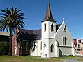
The Sir Joseph Banks Hotel was a popular hotel on the shores of Botany Bay. By 1850, a private zoo had been established there and visitors could go horse riding, play cricket and football. International athletes challenged the locals in the Sir Joseph Banks Handicap on the racetrack. In 1988, the Sir Joseph Banks Pleasure Gardens were refurbished with local industry contributions. The racing track was restored and an annual event called the Botany Bay Gift attracted international athletes again. The hotel, which was built in stages from 1840, is now listed on the Register of the National Estate. [5] The other historic landmark in the area is St Matthew's Church of England, on the corner of Botany Road and Lord Street. It was built in 1862 and is now on the Register of the National Estate. [6]

Former tram line service

The city line to Botany opened in 1882 as a steam tramway, with electric services commencing in 1903. The service from Circular Quay initially via Elizabeth, Chalmers and Redfern Streets (from 1902), then in 1933 via Pitt and Castlereagh Streets, and Eddy Avenue, Lee and Regents Streets, to Botany Street in Waterloo. A single-track connection along Bourke and O'Dea Streets joined at the present day Green Square, allowing access to the Dowling Street Depot. The line then passed down the entire length of Botany Road to Botany.

In Mascot, a branch led to the former Ascot Racecourse at the site of Sydney Airport. Points were provided at Bay Street on Botany Road in Botany, for short working. The line was double track throughout. From Botany, a single-track line crossed the Botany Goods railway at Beauchamp Road, then passed along Perry Street and Bunnerong Road, past the former Bunnerong Power Station to join the La Perouse line at Yarra Junction. Generally a shuttle service operated on this single track section between Botany and La Perouse. This single-track line was cut back to Military Road in 1935. The line from the junctions at Cleveland Street to Botany closed in 1960. Transdev John Holland bus route 309 generally follows the route.

Heritage listings

Botany has a number of heritage-listed sites, including:

Demographics

According to the 2021 census of Population, there were 12,960 people in Botany.

Commercial area

Port Botany is the site of Sydney's major port and as such, Botany is a suburb with extensive commercial development centred on shipping and freight. Botany also has a large chemical production facility owned by several companies including Huntsman and Orica (previously ICI). The plant was built in the 1940s and has been owned by Orica since 1997. [9] The plant once manufactured paints, plastics and industrial chemicals such as solvents, and is responsible for a large groundwater plume of pollution in the area. The main shopping centre in Botany runs along Botany Road.

Sir Joseph Banks Park

Sir Joseph Banks Park comprises Foreshore Reserve and the Sir Joseph Banks Pleasure Gardens. Foreshore Reserve is 28 hectares of bushland on land reclaimed from Botany Bay. The Reserve features walking tracks through sand dunes to protected wetlands, formed around a network of ponds. The Pleasure Gardens reflect the history of the area with a zoo playground featuring life size animal statues, a mosaic depicting Banks's journey, decorative flag terrace, Banksia garden and the central oval running track. A statue of Sir Joseph Banks examining botanical specimens is located in the pleasure gardens.

Sport and recreation

A number of well-known sporting teams represent the local area. One of them is the well known NRL club named the South Sydney Rabbitohs and Botany Rams some other teams are Pagewood Botany Soccer Club, Botany Golf Club, Bonnie Doon Golf Club, Eastlake Golf Club and The Lakes Golf Club. Lady Robinsons Beach is a prominent beach in the area.

Schools

Botany Public School is located in Botany Road. The original schoolroom is a small brick building with Gothic influences, built in 1868. [10]

Botany Public School, Botany Road BotanyRoad8.JPG
Botany Public School, Botany Road

Related Research Articles

<span class="mw-page-title-main">Mascot, New South Wales</span> Suburb of Sydney, New South Wales, Australia

Mascot is an inner south and west suburb of Sydney, in the state of New South Wales, Australia. Mascot is located 7 kilometres south of the Sydney central business district and is one of the administrative centres of the Bayside Council. A small part of Mascot is located in the Inner West Council. Mascot is on the north-west side of Botany Bay and contains Sydney Airport.

<span class="mw-page-title-main">Rhodes, New South Wales</span> Suburb of Sydney, New South Wales, Australia

Rhodes is an Inner West suburb of Sydney, in the state of New South Wales, Australia. Rhodes is located 12 kilometres west of the Sydney central business district, in the local government area of the City of Canada Bay. It was formerly part of Concord Municipality until a merger with Drummoyne Council to form Canada Bay in December 2000.

<span class="mw-page-title-main">La Perouse, New South Wales</span> Suburb of Sydney, New South Wales, Australia

La Perouse is a suburb in the Eastern Suburbs of Sydney, in the state of New South Wales, Australia. The suburb of La Perouse is located about 14 kilometres (8.7 mi) southeast of the Sydney central business district, in the City of Randwick.

<span class="mw-page-title-main">Oatley, New South Wales</span> Suburb of Sydney, New South Wales, Australia

Oatley is a suburb in Southern Sydney in the state of New South Wales, Australia. It is located 18 kilometres south of the Sydney central business district and is part of the St George area. Oatley lies in the local government area of Georges River Council. It lies on the northern side of the tidal estuary of the Georges River and its foreshore includes part of Oatley Bay and Lime Kiln Bay, and all of Neverfail Bay, Gungah Bay and Jewfish Bay.

<span class="mw-page-title-main">Brighton-Le-Sands, New South Wales</span> Suburb of Sydney, New South Wales, Australia

Brighton Le Sands, is a suburb in southern Sydney, in the state of New South Wales, Australia. Brighton Le Sands is located 13 kilometres south of the Sydney central business district, on the western shore of Botany Bay. Brighton Le Sands is in the local government area of the Bayside Council and is part of the St George area.

<span class="mw-page-title-main">Kingsford, New South Wales</span> Suburb of Sydney, New South Wales, Australia

Kingsford is a suburb in the Eastern Suburbs of Sydney, in the state of New South Wales, Australia. Kingsford is located 7 kilometres south-east of the Sydney central business district, in the local government area of the City of Randwick. Kingsford is part of the Eastern Suburbs region.

<span class="mw-page-title-main">Matraville, New South Wales</span> Suburb of Sydney, New South Wales, Australia

Matraville is located in the Eastern Suburbs of Sydney, in the state of New South Wales, Australia. It is approximately 9 km (6 mi) by road south-east of the Sydney central business district, in the local government area of the City of Randwick.

<span class="mw-page-title-main">Alexandria, New South Wales</span> Suburb of Sydney, New South Wales, Australia

Alexandria is an inner southern suburb of Sydney, New South Wales, Australia. Alexandria is located 5 kilometres south of the Sydney central business district and is part of the local government area of the City of Sydney. The postcode is 2015.

<span class="mw-page-title-main">Five Dock</span> Suburb of Sydney, New South Wales, Australia

Five Dock is a suburb in the Inner West of Sydney, in the state of New South Wales, Australia. Five Dock is located 10 kilometres west of the Sydney central business district, in the local government area of the City of Canada Bay.

<span class="mw-page-title-main">Sandringham, New South Wales</span> Suburb of Sydney, New South Wales, Australia

Sandringham is a suburb in southern Sydney, in the state of New South Wales, Australia. Sandringham is located 18 kilometres south of the Sydney central business district and is part of the St George area. Sandringham is in the local government area of the Bayside Council.

<span class="mw-page-title-main">Pagewood, New South Wales</span> Suburb of Sydney, New South Wales, Australia

Pagewood is a suburb in the Eastern Suburbs of Sydney, in the state of New South Wales, Australia, 8 kilometres south of the Sydney central business district. It is part of the Bayside Council.

<span class="mw-page-title-main">Maroubra, New South Wales</span> Suburb of Sydney, New South Wales, Australia

Maroubra is a beachside suburb in the Eastern Suburbs of Sydney, in the state of New South Wales, Australia. It is 10 kilometres south-east of the Sydney central business district in the local government area of the City of Randwick.

<span class="mw-page-title-main">Kurnell, New South Wales</span> Suburb of Sydney, New South Wales, Australia

Kurnell is a suburb in Sydney, in the state of New South Wales, Australia. It is 21.4 kilometres (13.3 mi) south of the Sydney central business district, in the local government area of the Sutherland Shire along the east coast. Cronulla and Woolooware are the only adjacent suburbs. La Perouse is located opposite, on the northern headland of Botany Bay. The Cronulla sand dunes are on the south eastern headland of Botany Bay. The eastern side of the peninsula is part of Botany Bay National Park, and Towra Point Nature Reserve is located on the western side of the suburb.

<span class="mw-page-title-main">Banksmeadow</span> Suburb of Sydney, New South Wales, Australia

Banksmeadow is a suburb located in the Eastern Suburbs of Sydney, within the state of New South Wales, Australia. Situated 11 kilometres south of the Sydney central business district, it falls under the jurisdiction of the Bayside Council. Banksmeadow is positioned on the northern shores of Botany Bay.

<span class="mw-page-title-main">Banksia, New South Wales</span> Suburb of Sydney, New South Wales, Australia

Banksia is a suburb in southern Sydney, in the state of New South Wales, Australia. Banksia is located 12 kilometres south of the Sydney central business district, in the local government area of the Bayside Council and is part of the St George area.

<span class="mw-page-title-main">Daceyville</span> Suburb of Sydney, New South Wales, Australia

Daceyville is a suburb in the Eastern Suburbs of Sydney, in the state of New South Wales, Australia. Daceyville is 7 km south of the Sydney central business district and is now part of Bayside Council.

<span class="mw-page-title-main">Eastgardens, New South Wales</span> Suburb of Sydney, New South Wales, Australia

Eastgardens is a suburb in the Eastern Suburbs of Sydney, in the state of New South Wales, Australia. Eastgardens is located 9 km south-east of the Sydney central business district and is part of the Bayside Council.

<span class="mw-page-title-main">Malabar Headland</span> Historic site in New South Wales, Australia

The Malabar Headland is a heritage-listed former public recreation area and military installation site and now nature conservation and public recreation headland area located at Franklin Street, Malabar in the City of Randwick local government area of New South Wales, Australia. It is also known as Long Bay Rifle Range, Anzac Rifle Range and Boora Point. The property is owned by the New South Wales Government. It was added to the New South Wales State Heritage Register on 22 July 2005.

<span class="mw-page-title-main">Botany Water Reserves</span> Historic site in New South Wales, Australia

The Botany Water Reserves are a heritage-listed former water supply system and now parkland and golf course at 1024 Botany Road, Mascot, Bayside Council, Sydney, New South Wales, Australia. It was designed by City Engineers, W. B. Rider, E. Bell (1856–1871), and Francis Bell (1871–1878). It is also known as Botany Dams, Botany Swamps, Botany Wetlands, Mill Stream, Bridge Pond, The Lakes Golf Club, Eastlakes Golf Course, Bonnie Doon Golf Club, and Astrolabe Park. The property is owned by Sydney Water, an agency of the Government of New South Wales. It was added to the New South Wales State Heritage Register on 18 November 1999.

The Chinese Market Gardens is a heritage-listed market gardens at 1-39 Bunnerong Road, La Perouse, City of Randwick, New South Wales, Australia. It is also known as Chinese Gardens La Perouse, Phillip Bay, Matraville and Randwick. The property is Crown land and is owned by NSW Department of Industry, a department of the Government of New South Wales. It was added to the New South Wales State Heritage Register on 13 August 1999.

References

  1. 1 2 Australian Bureau of Statistics (28 June 2022). "Botany (State Suburb)". 2021 Census QuickStats. Retrieved 7 November 2022. OOjs UI icon edit-ltr-progressive.svg
  2. Gregory's Sydney Street Directory, Gregory's Publishing Company, 2007
  3. Book of Sydney Suburbs, Frances Pollon (Angus and Robertson) 1990, p.35
  4. Book of Sydney Suburbs, p.35
  5. The Heritage of Australia, Macmillan Company, 1981, p.2/14
  6. The Heritage of Australia, p.2/14
  7. "Sir Joseph Banks Hotel (former)". New South Wales State Heritage Register . Department of Planning & Environment. H00076. Retrieved 18 May 2018. CC BY icon.svg Text is licensed by State of New South Wales (Department of Planning and Environment) under CC-BY 4.0 licence .
  8. "Botany Post Office (Place ID 106143)". Australian Heritage Database . Australian Government . Retrieved 22 September 2018.
  9. "Botany pollution fears grow". The Sydney Morning Herald. 2005. Retrieved 24 July 2010.
  10. "Home". botany-p.schools.nsw.edu.au.

33°56′42″S151°11′58″E / 33.94513°S 151.19934°E / -33.94513; 151.19934