Long Gully Bridge

Last updated

Long Gully Bridge
Long Gully Bridge, Northbridge NSW.jpg
Long Gully Bridge from Tunks Park
Coordinates 33°49′00″S151°12′44″E / 33.8168°S 151.2123°E / -33.8168; 151.2123
CarriesStrathallen Avenue
CrossesFlat Rock Creek
Locale Cammeray, Northbridge, New South Wales, Australia
Other name(s)Northbridge; Suspension Bridge; Cammeray Bridge
Characteristics
Design Victorian Gothic arch bridge
Material Sydney sandstone
Trough construction Concrete
Height51 metres (167 ft)
Longest spanOriginal timber deck:
152 metres (500 ft)
Current concrete deck:
105 metres (344 ft)
No. of spans1
History
ArchitectD. Ross
Constructed byHornibrook Bros, Clark Pty Ltd
OpenedJanuary 1892 (1892-01)
New South Wales Heritage Database
(Local Government Register)
TypeLocal heritage (built)
Criteria a., c., e., e., f.
Designated30 May 2011
Reference no.I229
TypeTransport – Land
CategoryRoad bridge
Location
Long Gully Bridge

The Long Gully Bridge, also known as Northbridge, Suspension Bridge, and Cammeray Bridge, is a concrete arch road bridge that carries Strathallen Avenue across Flat Rock Creek and Tunks Park, and connects the suburbs of Cammeray, in the North Sydney Council local government area to its south, with Northbridge in the City of Willoughby local government area to its north, in Sydney, New South Wales, Australia.

Contents

Privately-built to promote residential development in the suburb of Northbridge and beyond, the bridge opened in January 1892 as a steel suspension bridge finished in Sydney sandstone with crenellated turreted towers. The bridge was transferred to the Department of Main Roads in 1935 and, in 1939, was rebuilt as a reinforced concrete two rib arch bridge, with the sandstone towers kept. [1] [2] [3] [4]

History

Original bridge

The suspension bridge, early 1900s SLNSW 796752 Suspension Bridge North Sydney.jpg
The suspension bridge, early 1900s

With the land boom of the 1880s, land to the north of Long Bay, Middle Harbour, was sold and resold. The North Sydney Investment and Tramway Company or the North Shore and Middle Harbour Land Company made major investments in the area and planned to build a tramway and a bridge across Long Bay gully in order to open up the area for sales of residential land. A suspension bridge across the gully was opened to traffic in January 1892. It had taken two years and nine months to complete and cost 42,000. With a suspension span of 152 metres (500 ft) centre to centre of towers, it was considered one of the engineering wonders of Sydney and became a great tourist attraction. [1]

As a suspension bridge, 1890s Middle Harbour Bridge, North Sydney (4903243213).jpg
As a suspension bridge, 1890s

A toll of threepence return for adults and one penny for children was charged. The disastrous crash of 1892 saw both the above companies go into liquidation. The Depression of the 1890s slowed land sales and Northbridge did not develop as had been hoped; the tramway was not built. [1] In 1894 a fundraising dance and promenade concert was held on the bridge. [5] In 1912 the bridge was handed over to the NSW Government as a gift, on the condition that a tramway be extended to the north side and no toll charged. The tramway was extended over the bridge in 1913-14, with its terminus in Sailors Bay Road. [1]

Between its construction and its handing over to the Department of Public Works, the bridge was little used and poorly maintained for many years. Repairs and some strengthening works were carried out in conjunction with the construction of the tramway. [6] The Department of Main Roads (DMR) assumed control of the bridge in 1935 and inspections soon revealed serious corrosion in the steelwork and cables, partly attributable to defects in the design of the bridge. Water had been allowed to accumulate around the suspension rods as they passed through the cross girder ends in small, undrained reserves that had originally been filled with a bituminous mixture, which had not stood the test of time. The main suspension cables were also found to be weakened by corrosion. [1]

The bridge was carefully monitored and it rapidly became clear that replacement or substantial rebuilding would be necessary. From several options, it was decided that a large concrete arch span to support the deck of the old suspension bridge was the most satisfactory solution. The towers themselves were in very good condition and were recognised by the DMR as having local significance as a landmark and tourist attraction and as having considerable historical value. For these reasons they were retained and repeated in the design of the new work, with much attention to sympathetic design. [1] The bridge closed in May 1936. [7] [8]

Current bridge

The arch of the bridge from Tunks Park Long Gully Bridge, Northbridge.jpg
The arch of the bridge from Tunks Park

The arch was designed and tested through the analysis of models within the DMR. [9] The construction contract was awarded to Hornibrook Bros. & Clark Pty. Ltd. The bridge was closed to tram and vehicular (but not pedestrian [10] ) traffic and work began at the beginning of June 1937.

While a 'Melan' system using a steel rib to serve as falsework and then reinforcement in the completed structure had been considered, the tenderers favoured the conventional system of timber falsework, and it was this system which was employed. An interesting innovation, however, was employed in the form of steel cylinders with base plate partly filled with a fine dune sand and fitted with a hardwood piston. The pistons bore the weight of the girders until it was time to strike the falsework when two small screw plugs on the cylinders could be opened to a carefully prepared schedule, with a large team of operators working to signals, and sand released so that the crown and then, gradually, the whole arch took up its own load.

Worker safety was also an important factor in the design of construction methods for the bridge.

The bridge was re-opened to traffic in late 1939. [11]

Description

Northern turrets of the bridge Long Gully Bridge, Northbridge - northern end.jpg
Northern turrets of the bridge

The original suspension bridge had a 152-metre (500 ft) main span supported by steel cables and steel hanger rods. The deck was stiffened by an undertruss which was pin connected at the centre of the span. The steel cables were supported on ornate sandstone turrets and anchored into bedrock at each end of the gorge. The wooden deck carried two lanes of traffic plus two tram tracks and footways. [1]

Deterioration of the bridge due to corrosion led to the replacement of the suspension design by an arch in the 1930s. With a main span of 105 metres (344 ft), the arch consists of two concrete ribs, peaking some 51 metres (167 ft) above stream level. Supported on the arches are columns carrying the deck on 14 reinforced concrete beam slab spans. The deck has expansion joints at the large piers directly over the arch springs. These also transfer wind load from the arch and deck back to the foundations.

Roadway Long Gully Bridge, Northbridge - 29853356573.jpg
Roadway

Connecting these to the original turrets are 15-metre (50 ft) concrete beam spans. The concrete detailing was done in Victorian Gothic and Norman styles to reflect the Gothic sandstone towers, the main piers being given Norman castle features.

As part of the reconstruction the roadway openings through the towers were increased to nine metres (thirty feet), and walkway openings cut through the towers. The bridge has light standards supported by the concrete railings. [1]

Modifications

Heritage listing

Plaque NorthbridgePlaque2.JPG
Plaque

The bridge is intimately associated with the residential development of the area to the north of the bridge, essential infrastructure which allowed its development to proceed in the late nineteenth century. The concrete arch which was built 1936-9 is a fascinating episode in the bridge's history. The process of the design and construction of the arch is illustrative of an era in the history of bridge building in the Department of Main Roads. It is linked with the local historical theme of engineering and building the road system. The use of the concrete arch solution to support the older bridge and to allow its landmark features to be retained was a creative and heritage-sensitive response to an infrastructure problem in an era long before heritage values and processes were enshrined in legislation. [1]

See also

Related Research Articles

<span class="mw-page-title-main">Sydney Harbour Bridge</span> Bridge across Sydney Harbour in Australia

The Sydney Harbour Bridge is a steel through arch bridge in Sydney, New South Wales, Australia, spanning Sydney Harbour from the central business district (CBD) to the North Shore. The view of the bridge, the harbour, and the nearby Sydney Opera House is widely regarded as an iconic image of Sydney, and of Australia itself. Nicknamed "The Coathanger" because of its arch-based design, the bridge carries rail, vehicular, bicycle and pedestrian traffic.

<span class="mw-page-title-main">Arch bridge</span> Bridge with arch-shaped supports

An arch bridge is a bridge with abutments at each end shaped as a curved arch. Arch bridges work by transferring the weight of the bridge and its loads partially into a horizontal thrust restrained by the abutments at either side. A viaduct may be made from a series of arches, although other more economical structures are typically used today.

<span class="mw-page-title-main">Gladesville Bridge</span> Bridge in Sydney, Australia

Gladesville Bridge is a heritage-listed concrete arch road bridge that carries Victoria Road over the Parramatta River, linking the Sydney suburbs of Huntleys Point and Drummoyne, in the local government areas of Canada Bay and Hunter's Hill, in New South Wales, Australia. Despite its name, the bridge is not in Gladesville.

Cammeray is a residential suburb located five kilometres north of the Sydney Central Business District (CBD) and is part of the North Sydney Council local government area. Cammeray is part of the Lower North Shore region of Northern Sydney.

<span class="mw-page-title-main">Ryde Bridge</span> Bridges across the Parramatta River in Sydney, Australia

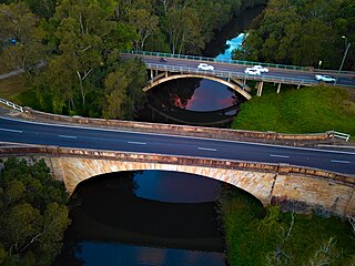
The Ryde Bridge, also called the Uhrs Point Bridge, are two road bridges that carry Concord Road, part of the A3, across Parramatta River from Ryde in the northern suburbs of Sydney to Rhodes in Sydney's inner west, in New South Wales, Australia.

<span class="mw-page-title-main">Northbridge, New South Wales</span> Suburb of Sydney, New South Wales, Australia

Northbridge is a suburb on the Lower North Shore of Sydney, New South Wales, Australia. It is located 6 kilometres north of the Sydney Central Business District, in the local government area of the City of Willoughby.

<span class="mw-page-title-main">Hampden Bridge, Kangaroo Valley</span> Bridge in New South Wales, Australia

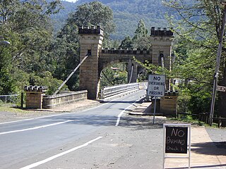
Hampden Bridge is a heritage-listed single-span suspension bridge that carries Moss Vale Road (B73) across the Kangaroo River, in Kangaroo Valley, in the City of Shoalhaven local government area of New South Wales, Australia. The bridge was designed by Ernest de Burgh and built by Loveridge and Hudson. The property is owned by Transport for NSW. It was added to the New South Wales State Heritage Register on 2 August 2019.

<span class="mw-page-title-main">Nowra Bridge</span> Bridge in New South Wales, Australia

The Nowra Bridge is a road bridge that carries the Princes Highway over the Shoalhaven River, at Nowra, New South Wales, Australia. The bridge joins the main area of Nowra to North Nowra and Bomaderry.

<span class="mw-page-title-main">Spit Bridge</span> Bridge across the Middle Harbour in Sydney, Australia

The Spit Bridge, a steel and concrete girder bridge with a bascule lift span across the Middle Harbour, is located 10 kilometres (6.2 mi) north-east of the central business district in Sydney, Australia. The bridge carries The Spit Road (A8) from a point called The Spit, and connects the suburbs of Mosman, on the south bank and Seaforth, on the north bank.

<span class="mw-page-title-main">Denison Bridge</span> Bridge in Bathurst, New South Wales

The Denison Bridge is a heritage-listed footbridge over the Macquarie River in Bathurst, New South Wales, Australia. It is the fourth oldest metal truss bridge existing in Australia.

<span class="mw-page-title-main">Peats Ferry Bridge</span> Bridge in New South Wales, Australia

The Peats Ferry Bridge is a steel truss bridge that carries the Pacific Highway (B83) across the Hawkesbury River, between Kangaroo Point and Mooney Mooney Point, located 40 kilometres (25 mi) north of Sydney in New South Wales, Australia. The bridge carries the Hornsby to Kariong section of highway, while the adjacent Brooklyn Bridge carries the Pacific Motorway (M1).

<span class="mw-page-title-main">Bethanga Bridge</span> Bridge in Victoria, Australia

The Bethanga Bridge is a steel truss road bridge that carries the Riverina Highway across Lake Hume, an artificial lake on the Murray River in Australia. The dual heritage-listed bridge crosses the border between the Australian states of New South Wales and Victoria, linking the Victorian towns of Bellbridge and Bethanga with the regional New South Wales city of Albury.

<span class="mw-page-title-main">Lansdowne Bridge</span> Bridge

The Lansdowne Bridge is a heritage-listed road bridge that carries the northbound carriageway of the Hume Highway across Prospect Creek between Lansvale and Lansdowne. Situated in southwestern Sydney it is located on the boundary of the Fairfield and Canterbury-Bankstown local government areas. The bridge was named in honour of Henry Petty-Fitzmaurice, 3rd Marquess of Lansdowne (1780–1863), an Irish Whig politician of the British Parliament and associate of the NSW Governor of the day, Sir Richard Bourke.

<span class="mw-page-title-main">Boothtown Aqueduct</span> Bridge

The Boothtown Aqueduct is a heritage-listed 19th-century, Victorian Romanesque style water bridge in Greystanes, Sydney, New South Wales, Australia. Established in 1888, the aqueduct was built to cross a valley to carry water from Prospect Reservoir to residents of Greater Western Sydney.

<span class="mw-page-title-main">Yowaka River bridge, Greigs Flat</span> Bridge in New South Wales, Australia

The Yowaka River bridge is a heritage-listed road bridge that carries the Princes Highway across the Yowaka River at Greigs Flat, New South Wales, Australia. It was built in 1936. The bridge is also known as the Yowaka Bridge near Eden. The bridge is owned by Transport for NSW. It was added to the New South Wales State Heritage Register on 20 June 2000.

<span class="mw-page-title-main">Tunks Creek Bridge</span> Bridge in New South Wales, Australia

The Tunks Creek Bridge is a heritage-listed timber truss road bridge that carries Galston Road across Tunks Creek, in Galston, New South Wales, Australia. The bridge spans Tunks Creek in the valley of the Galston Gorge. The road through the gorge provides a link between Hornsby Heights and Galston, suburbs of Sydney. The bridge is also known as the Bridge over Tunks (Pearces) Creek and Pearces Creek Bridge. The bridge is owned by Transport for NSW. It was added to the New South Wales State Heritage Register on 20 June 2000.

<span class="mw-page-title-main">Cooks River Sewage Aqueduct</span> Historic site in New South Wales, Australia

The Cooks River Sewage Aqueduct is a heritage-listed sewage aqueduct located at Pine Street, Earlwood, New South Wales, Australia. It crosses the Cooks River to Thornley Street, Marrickville. It was designed by Sewerage Construction Branch and NSW Department of Public Works and built during 1895 by J. F. Carson, contractor. The property is owned by Sydney Water, an agency of the Government of New South Wales. It was added to the New South Wales State Heritage Register on 18 November 1999.

<span class="mw-page-title-main">Mosman Bay Sewage Aqueduct</span> Historic site in New South Wales, Australia

The Mosman Bay Sewage Aqueduct is a heritage-listed public pedestrian bridge and sewage aqueduct at Avenue Road, Mosman in the Mosman Council local government area of New South Wales, Australia. It was designed by Sewerage Construction Branch and NSW Department of Public Works and built from 1899 to 1901 by NSW Department of Public Works. It is also known as the Aqueduct over Mosman Bay. The property is owned by Sydney Water, an agency of the Government of New South Wales. It was added to the New South Wales State Heritage Register on 18 November 1999.

<span class="mw-page-title-main">Hay Bridge, New South Wales</span> Bridge in New South Wales, Australia

The Hay Bridge is a road bridge that carries the Cobb Highway across the Murrumbidgee River at Hay, New South Wales, Australia. The current bridge is the second bridge located in Hay that crosses the Murrumbidgee; the first bridge was in operation from 1873 until 1973; the second and current bridge has operated since 1973.

<span class="mw-page-title-main">Ray Wedgwood</span> Australian civil and bridge engineer (1942-2020)

Raymond John Lloyd Wedgwood was an Australian engineer who served as the Chief Bridge Engineer of the Department of Main Roads and the Roads & Traffic Authority in New South Wales. He designed and supervised the construction of many major bridges across New South Wales and led the design team for the cable stayed Anzac Bridge in Sydney. He also played a pivotal role in the development of a common code of bridge design practice used by all Australian state road authorities.

References

  1. 1 2 3 4 5 6 7 8 9 "Suspension Bridge". New South Wales Heritage Database. Office of Environment & Heritage . Retrieved 23 March 2020.
  2. "Suspension Bridge, New South Wales Heritage Database (NSW HD) Number HI229". New South Wales Heritage Database. Office of Environment & Heritage . Retrieved 23 March 2020.
  3. "Suspension Bridge over Tunks Park, New South Wales Heritage Database (NSW HD) Number H1995". New South Wales Heritage Database. Office of Environment & Heritage . Retrieved 23 March 2020.
  4. "Willoughby Local Environmental Plan 2012". NSW legislation. Government of New South Wales. 15 January 2020. Retrieved 23 March 2020.
  5. "ENTERTAINMENT ON THE NORTH SYDNEY SUSPENSION BRIDGE". The Sydney Morning Herald . 12 November 1894. p. 6. Retrieved 23 March 2020 via Trove, National Library of Australia.
  6. Main Roads Journal, August 1937, p.152.
  7. "Closing Of Suspension Bridge". The Sun . Sydney. 28 May 1936. p. 23. Retrieved 23 March 2020 via Trove, National Library of Australia.
  8. "Suspension Bridge". The Daily Telegraph . Sydney. 27 May 1936. p. 7. Retrieved 23 March 2020 via Trove, National Library of Australia.
  9. Main Roads Journal, August 1937, p.152-155.
  10. "Suspension Bridge to be rebuilt". The Daily Telegraph . Sydney. 7 July 1936. p. 7. Retrieved 23 March 2020 via Trove, National Library of Australia.
  11. Main Roads Journal, August 1939, p.113-116.

Attribution

Further reading