Sydney Trains is the operator of commuter rail services centred on the Sydney rail network. Sydney Trains is owned and operated by Transport for NSW, a statutory authority of the Government of New South Wales.
The Sydney Trains network comprises seven metropolitan lines with services extending as far as Berowra to the north, Richmond to the north-west, Emu Plains to the west, Waterfall to the south (with some peak hour services continuing to Helensburgh), and Macarthur to the south west.
Most of the Sydney Trains network runs on the surface of suburban areas while some more recently constructed and inner city sections run underground. The network is served by a fleet of double-deck electric multiple units.
Station | Code | Image | Served by | Railway line(s) | Distance from Central station (km) [1] [2] [3] [4] [5] [6] [7] [8] [9] [10] | Date Opened | Previous name(s) | Transport connections |
---|---|---|---|---|---|---|---|---|
Allawah | ALW | Illawarra | 13.690 | 25 October 1925 | ||||
Arncliffe | ARN | 8.420 | 15 October 1884 | |||||
Artarmon | ATM | North Shore | 10.300 | 6 July 1898 (original site), 7 October 1900 (present site) | ||||
Ashfield | ASH | Main Suburban | 8.380 | 26 September 1855 | ||||
Asquith | ASQ | Main Northern | 35.690 | 1 November 1915 | ||||
Auburn | AUB | Main Suburban | 18.630 | 18 February 1877 | ||||
Banksia | BKS | Illawarra | 9.600 | 21 October 1906 | ||||
Bankstown | BNK | Bankstown | 18.720 | 14 April 1909 | ||||
Bardwell Park | BPK | East Hills | 10.100 | 21 September 1931 | ||||
Beecroft | BCF | Main Northern | 26.900 | 17 September 1886 (original site) 7 March 1892 (present site) | ||||
Belmore | BMR | Bankstown | 13.250 | 1 February 1895 | ||||
Berala | BEJ | Main South | 18.360 | 11 November 1912 | ||||
Berowra | BEW | Main Northern | 44.660 | 7 April 1887 | NSW TrainLink intercity | |||
Beverly Hills | BVH | East Hills | 14.650 | 21 September 1931 | Dumbleton (1931–1940) | |||
Bexley North | BXN | East Hills | 11.370 | 21 September 1931 | ||||
Birrong | BIO | Bankstown | 22.110 | 16 July 1928 | ||||
Blacktown | BAK | Main Western Richmond | 34.870 | 4 July 1860 | Blacktown Road (1860–1862) | Major Interchange NSW TrainLink intercity | ||
Bondi Junction | BJN | Eastern Suburbs | 6.760 | 23 June 1979 | ||||
Burwood | BUW | Main Suburban | 10.620 | 26 September 1855 (original site) 13 March 1892 (present site) | ||||
Cabramatta | CAB | Main South | 28.430 | 1870 | ||||
Campbelltown | CTN | 54.710 | 17 May 1858 | Major Interchange NSW TrainLink Buses | ||||
Campsie | CMP | Bankstown | 11.700 | 1 February 1895 | ||||
Canley Vale | CVE | Old Main South | 30.980 | 15 April 1878 | ||||
Canterbury | CTB | Bankstown | 10.160 | 1 February 1895 | ||||
Caringbah | CIH | Cronulla | 31.510 | 16 December 1939 | ||||
Carlton | CLJ | Illawarra | 12.740 | 1889 | ||||
Carramar | CRR | Main South | 25.890 | 8 October 1924 | South Fairfield (1924–1926) | |||
Casula | CSL | 38.800 | 1 November 1894 | |||||
Central | CEN | Main Suburban North Shore Illawarra | 0.00 | 26 September 1855 (original site) 5 August 1906 (present site) 3 October 1926 (electric platforms) 23 June 1979 (underground platforms) | Sydney (1855–1926) | Major Interchange Metro (under construction) NSW TrainLink Buses Light Rail Indian Pacific | ||
Chatswood | CWD | North Shore | 11.650 | 1 January 1890 | Major Interchange Metro Buses | |||
Cheltenham | CHA | Main Northern | 25.380 | 10 October 1898 | ||||
Chester Hill | CHH | Main South | 22.310 | 8 October 1924 | ||||
Circular Quay | CQY | City Circle | 2.970 | 22 January 1956 | Major Interchange Buses Ferries Light Rail | |||
Clarendon | CRD | Richmond | 57.210 | 1870 | Hawkesbury Racecourse (1870–1876) | |||
Clyde | CYE | Main Suburban | 20.660 | 1882 | Rosehill Junction (1882–1883) Clyde (1883–1901) Clyde Junction (1901–1904) | |||
Como | CMO | Illawarra | 21.240 | 26 December 1885 (original site) 27 November 1972 (present site) | ||||
Concord West | CDW | Main Northern | 14.540 | 1 September 1887 | Concord (1887–1909) | |||
Cronulla | CNL | Cronulla | 34.810 | 16 December 1939 | Buses | |||
Croydon | CYD | Main Suburban | 9.420 | 7 January 1875 | Five Dock (1875–1876) | |||
Denistone | DST | Main Northern | 20.160 | 26 September 1937 | ||||
Domestic Airport | DOM | Airport | 6.600 | 21 May 2000 | Buses | |||
Doonside | DOD | Main Western | 38.290 | 27 September 1880 | Doonside (1880–1921) Wolkara (1921) | |||
Dulwich Hill | DHM | Bankstown | 7.870 | 1 February 1895 | Wardell Road (1895–1920) | Buses Light Rail | ||
East Hills | EHS | East Hills | 24.030 | 21 December 1931 | ||||
East Richmond | ERD | Richmond | 60.000 | 2 July 1939 | ||||
Eastwood | EWD | Main Northern | 21.390 | 17 September 1886 | ||||
Edgecliff | ECL | Eastern Suburbs | 4.820 | 23 June 1979 | Buses | |||
Edmondson Park | EDP | South West | 43.16 | 8 February 2015 | ||||
Emu Plains | EPS | Main Western | 57.440 | 18 August 1868 (original site) 1884 (present site) | NSW TrainLink intercity | |||
Engadine | EGD | Illawarra | 30.750 | 1 October 1920 | ||||
Epping | EPG | Main Northern Epping to Chatswood | 23.390 | 17 September 1886 (original site) 15 February 1900 (present site) 23 February 2009 (underground platforms) | Field of Mars (1886–1887) Carlingford (1887–1899) | Major Interchange Metro NSW TrainLink intercity | ||
Erskineville | EKV | Illawarra | 2.880 | 15 October 1884 (original site) 16 June 1912 (present site) | ||||
Fairfield | FFL | Old Main South | 28.997 | 26 September 1856 | ||||
Flemington | FMG | Main Suburban | 14.332 | 1884 | ||||
Glenfield | GFD | Main South | 41.930 | 6 September 1869 (original site) 27 March 1891 (present site) | Major Interchange NSW TrainLink intercity Buses | |||
Gordon | GDN | North Shore | 17.120 | 1 January 1890 | ||||
Granville | GAV | Main Suburban | 21.220 | 2 July 1860 | Parramatta Junction (1860–1880) | Major Interchange Buses | ||
Green Square | GQE | Airport | 2.600 | 21 May 2000 | ||||
Guildford | GUD | Old Main South | 25.720 | April 1876 | ||||
Gymea | GYM | Cronulla | 27.940 | 16 December 1939 | ||||
Harris Park | HPK | Main Western | 22.530 | 1883 | ||||
Heathcote | HTC | Illawarra | 33.150 | 9 March 1886 | ||||
Helensburgh | HNB | Illawarra | 46.380 | 30 May 1915 | NSW TrainLink intercity Buses | |||
Holsworthy | HOL | East Hills | 27.760 | 21 December 1987 | ||||
Homebush | HSH | Main Suburban | 12.740 | 26 September 1855 | ||||
Hornsby | HBY | Main Northern North Shore | 33.860 | 17 September 1886 | Hornsby (1886–1894) Hornsby Junction (1894–1900) | Major Interchange NSW TrainLink intercity | ||
Hurlstone Park | HRL | Bankstown | 8.800 | 1 February 1895 | Fern Hill (1895–1911) | |||
Hurstville | HVL | Illawarra | 14.840 | 15 October 1884 | NSW TrainLink intercity Buses | |||
Ingleburn | IGB | Main South | 45.650 | 6 September 1859 | Macquarie Fields (1869–1883) | |||
International Airport | INT | Airport | 8.100 | 21 May 2000 | Buses | |||
Jannali | JNL | Illawarra | 22.720 | 7 February 1931 | ||||
Killara | KLA | North Shore | 15.890 | 10 June 1899 | ||||
Kings Cross | KSX | Eastern Suburbs | 3.410 | 23 June 1979 | ||||
Kingsgrove | KGV | East Hills | 12.620 | 21 September 1931 | ||||
Kingswood | KWD | Main Western | 52.700 | 1 September 1887 | Cross Roads (1887–1888) | |||
Kirrawee | KEE | Cronulla | 26.640 | 16 December 1939 | ||||
Kogarah | KGH | Illawarra | 11.610 | 15 October 1884 | ||||
Lakemba | LAK | Bankstown | 14.480 | 14 April 1909 | ||||
Leightonfield | LTN | Main South | 23.670 | 24 August 1942 | ||||
Leppington | LEP | South West | 44.28 | 8 February 2015 | ||||
Leumeah | LUM | Main South | 52.630 | 1886 | ||||
Lewisham | LWI | Main Suburban | 6.250 | 1886 (original site) 19 December 1891 (present site) | ||||
Lidcombe | LDC | 16.610 | 1 November 1858 | Haslems Creek (1858–1876) Rookwood (1876–1914) | Major Interchange Buses | |||
Lindfield | LDD | North Shore | 14.600 | 1 January 1890 | ||||
Liverpool | LPO | Main South | 35.680 | 26 September 1856 | Major Interchange Buses | |||
Loftus | LOF | Illawarra | 26.290cr | 9 March 1886 (original site) 9 June 1917 (present site) | Loftus Junction (1886–1896) | |||
Macarthur | MCA | Main South | 56.580 | 28 July 1985 | NSW TrainLink intercity Buses | |||
Macdonaldtown | MAC | Main Suburban | 2.480 | 1878 (original site) 3 April 1892 (present site) | ||||
Macquarie Fields | MQF | Main South | 43.800 | 3 October 1888 | ||||
Marayong | MYG | Richmond | 37.410 | 2 October 1922 | ||||
Marrickville | MKV | Bankstown | 6.580 | 1 February 1895 | ||||
Martin Place | MPC | Eastern Suburbs | 2.100 | 23 June 1979 | Future Major Interchange Metro (under construction) | |||
Mascot | MCO | Airport | 5.100 | 21 May 2000 | ||||
Meadowbank | MEB | Main Northern | 18.180 | 1 September 1887 | Meadow Bank (1887–1927) | |||
Merrylands | MLN | Old Main South | 23.470 | 6 July 1878 | ||||
Milsons Point | MPT | North Shore | 4.434 | 1 May 1893 (first site) 30 May 1915 (second site) 13 July 1915 (third site) 28 July 1924 (fourth site) 20 March 1932 (present site) | ||||
Minto | MIO | Main South | 49.670 | May 1874 | Campbellfields (1874–1882) | |||
Miranda | MIJ | Cronulla | 29.510 [11] | 16 December 1939 [11] | ||||
Mortdale | MDE | Illawarra | 17.060 | 20 March 1897 (original site) 14 September 1922 (present site) | ||||
Mount Colah | MOC | Main Northern | 37.680 | 1 July 1887 | Colah (1887–1906) | |||
Mount Druitt | MTT | Main Western | 43.290 | 1 November 1915 | ||||
Mount Kuring-gai | MKI | Main Northern | 43.840 | 19 August 1881 (original site) 8 December 1974 (present site) | Kuring-gai (1901–1904) | |||
Mulgrave | MUV | Richmond | 52.590 | 1 December 1864 (original site) 29 June 1939 (present site) | ||||
Museum | MSM | City Circle | 4.990 | 20 December 1926 | ||||
Narwee | NWE | East Hills | 15.780 | 21 December 1931 | ||||
Newtown | NTN | Main Suburban | 3.100 | 26 September 1855 | ||||
Normanhurst | NOR | Main Northern | 31.720 | 21 November 1895 | Hornsby (1895–1898) | |||
North Strathfield | NST | 13.380 | 9 June 1918 | |||||
North Sydney | NSY | North Shore | 5.130 | 20 March 1932 | ||||
Oatley | OAL | Illawarra | 18.280 | 1886 | Oatley (1886–1889) Oatley's (1889–1890) | |||
Olympic Park | OLP | Olympic Park | 17.330 | 1 May 1998 | Future Major Interchange Metro (Sydney Olympic Park metro station, under construction) Buses | |||
Padstow | PDW | East Hills | 19.340 | 21 December 1931 | ||||
Panania | PAN | 22.550 | ||||||
Parramatta | PAR | Main Western | 23.210 | 26 September 1855 (original site) 4 July 1860 (present site) | Major Interchange Metro (Parramatta metro station, under construction) NSW TrainLink intercity Buses | |||
Pendle Hill | PDH | 28.290 | 12 April 1924 | |||||
Pennant Hills | PNT | Main Northern | 28.580 | 17 September 1886 | ||||
Penrith | PNR | Main Western | 55.090 | 19 January 1863 | Major Interchange Buses | |||
Penshurst | PHS | Illawarra | 18.280 | 1886 (original site) 4 April 1905 (present site) | ||||
Petersham | PSM | Main Suburban | 5.500 | 6 January 1857 | ||||
Punchbowl | PCB | Bankstown | 16.450 | 14 April 1909 | ||||
Pymble | PYB | North Shore | 18.900 | 1 January 1890 | ||||
Quakers Hill | QKH | Richmond | 40.090 | 1872 (as siding) 30 March 1905 (original site) 29 June 1939 (present site) | Douglas Siding (1872–1905) | |||
Redfern | REF | Main Suburban Illawarra | 1.300 | 15 April 1878 [12] | Eveleigh (1878–1906) | Major Interchange NSW TrainLink intercity Buses | ||
Regents Park | RGP | Main South | 19.860 | 11 November 1912 (original site) 2 March 1914 (with platform) 8 October 1924 (present site) | ||||
Revesby | RSY | East Hills | 20.960 | 21 December 1931 | ||||
Rhodes | RDS | Main Northern | 16.580 | 17 September 1886 | ||||
Richmond | RCD | Richmond | 60.680 | 1 December 1864 | ||||
Riverstone | RVS | 45.960 | ||||||
Riverwood | RVD | East Hills | 20.960 | 21 December 1931 | Herne Bay (1931–1958) | |||
Rockdale | RKL | Illawarra | 10.410 | 15 October 1884 | ||||
Rooty Hill | RYH | Main Western | 40.910 | 23 December 1861 (originally) 1 January 1862 (with platform) 1 December 1864 (after closure 21 July 1862) | ||||
Roseville | RVL | North Shore | 13.270 | 1 January 1890 | Rossville (1890) | |||
Schofields | SFS | Richmond | 43.750 | 1870 (original site) 29 October 2011 (present site) | ||||
Sefton | SFT | Main South | 21.190 | 8 October 1924 | ||||
Seven Hills | SEV | Main Western | 32.060 | 1 December 1863 (originally) 6 February 1869 (with platform) | ||||
St James | STJ | City Circle | 4.400 | 20 December 1926 | ||||
St Leonards | SNL | North Shore | 8.410 | 1 January 1890 | ||||
St Marys | STM | Main Western | 47.420 | 1 May 1862 | South Creek (1862–1885) | Future Major Interchange Metro (under construction) | ||
St Peters | SAP | Illawarra | 3.810 | 15 October 1884 | ||||
Stanmore | SMN | Main Suburban | 4.670 | 1878 | ||||
Strathfield | STR | 11.810 | 9 July 1876 (original site) 23 September 1900 (second site) 6 November 1922 (present site) | Redmyre (1876–1885) | Major Interchange NSW TrainLink Buses | |||
Summer Hill | SMH | 7.030 | 15 September 1879 | |||||
Sutherland | SLD | Illawarra | 24.640 | 26 December 1885 | NSW TrainLink intercity Buses | |||
Sydenham | SDN | 5.310 | 15 October 1884 | Marrickville (1884–1895) | Future Major Interchange Metro (under construction) Buses | |||
Tempe | TME | 6.840 [13] | 15 October 1884 [13] | |||||
Thornleigh | THO | Main Northern | 29.430 [14] | 17 September 1886 [14] | ||||
Toongabbie | TGB | Main Western | 29.960 [15] | 26 April 1880 [15] | ||||
Town Hall | THL | North Shore City Circle Illawarra | 1.180 [16] | 28 February 1932 [16] | Major Interchange Metro (Gadigal, under construction) Buses Light Rail | |||
Turramurra | TMU | North Shore | 20.820 [17] | 1 January 1890 [17] | Eastern Road (1890) [17] | |||
Turrella | TLL | East Hills | 8.630 [18] | 21 September 1931 [18] | ||||
Villawood | VWD | Main South | 24.500 [19] | 8 October 1924 [19] | ||||
Vineyard | VYR | Richmond | 49.230 [20] | 14 July 1935 [20] | ||||
Wahroonga | WRO | North Shore | 22.770 [21] | 1 January 1890 [21] | Pearces Corner (1890) [21] | |||
Waitara | WTA | 24.210 [22] | 20 April 1895 [22] | |||||
Warrawee | WWE | 21.89 | 1 August 1900 [ citation needed ] | |||||
Warwick Farm | WWF | Main South | 28.430 [23] | 18 March 1889 [23] | ||||
Waterfall | WFL | Illawarra | 38.740 [24] | 9 March 1886 (original site) 1890 (second site) 4 May 1905 (present site) [24] | Waterfalls (1886) [24] | NSW TrainLink intercity | ||
Waverton | WVT | North Shore | 6.110 [25] | 1 May 1893 [25] | Bay Road (1893–1929) [25] | |||
Wentworthville | WVL | Main Western | 26.640 [26] | 1883 [26] | T R Smith's Platform (1883–1885) [26] | |||
Werrington | WRT | Main Western | 49.080 [27] | 2 May 1868 [27] | Parkes Platform (1868–1893) [27] | |||
West Ryde | WSR | Main Northern | 19.200 [28] | 17 September 1886 [28] | Ryde (1886–1945) [28] | |||
Westmead | WMD | Main Western | 25.160 [29] | March 1883 [29] | NSW TrainLink intercity Buses Light Rail | |||
Wiley Park | WLP | Bankstown | 15.350 [30] | 19 June 1938 [30] | ||||
Windsor | WSR | Richmond | 54.980 [31] | 1 December 1864 [31] | ||||
Wolli Creek | WCI, WCA, WCJ [32] | Airport Illawarra | 7.300 [33] | 21 May 2000 [34] | NSW TrainLink intercity Buses | |||
Wollstonecraft | WSC | North Shore | 7.180 [35] | 1 May 1893 [35] | Edwards Road (1893–1900) [35] | |||
Woolooware | WOE | Cronulla | 33.600 [36] | 16 December 1939 [36] | ||||
Wynyard | North Shore City Circle | 2.050 [37] | 28 February 1932 [37] | Major Interchange Metro (Barangaroo station, under construction) Buses Ferries (Barangaroo ferry wharf) Light Rail | ||||
Yagoona | YOA | Bankstown | 20.560 [38] | 16 July 1928 [38] | ||||
Yennora | YNR | Old Main South | 27.440 [39] | 6 November 1927 [39] |
The Airport & South Line is a suburban commuter rail line in Sydney, Australia. It connects the Sydney central business district with the southwestern suburbs via Sydney Airport. The line is part of the Sydney Trains network. The line began operating on 26 November 2017, when the T2 Airport, Inner West & South Line was split in two. Sydney Trains' predecessor CityRail operated the Airport & East Hills Line over an identical route between 2000 and 2013.
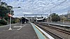
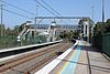
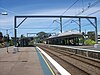
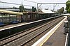
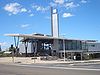
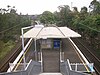
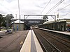
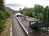
Wolli Creek railway station is located at the junction of the Airport and Illawarra lines, serving the Sydney suburb of Wolli Creek. It is served by Sydney Trains T4 Illawarra line, T8 Airport & South line services and NSW TrainLink South Coast line services.
The South Coast Railway is a commuter and goods railway line from Sydney to Wollongong and Bomaderry in New South Wales, Australia. Beginning at the Illawarra Junction, the line services the Illawarra and South Coast regions of New South Wales.
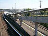
The East Hills railway line serves the southern and south-western suburbs of Sydney, Australia. The line opened to East Hills in 1931 and was extended to connect to the Main South Line in 1987. Most services along the line form part of the Airport & South Line operated by Sydney Trains.
The South Coast Line (SCO) is an intercity rail service operated by NSW TrainLink that services the Illawarra region of New South Wales, Australia. The service runs from Central, and runs the entire length of the eponymous South Coast railway line to Bomaderry. The service also runs along the Eastern Suburbs railway line at peak hours and the Port Kembla railway line to Port Kembla. It is operated with NSW TrainLink H sets and Sydney Trains T sets, with Endeavour railcars operating the service on the non-electrified line between Kiama and Bomaderry.
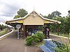
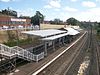
Gerringong railway station is a single-platform intercity train station located in Gerringong, New South Wales, Australia, on the South Coast railway line. The station serves NSW TrainLink diesel multiple unit trains travelling south to Bomaderry and north to Kiama. Early morning and late night services to the station are provided by train replacement bus services. In the past, the station precinct also catered to freight trains carrying dairy products.
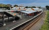
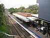
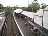
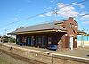
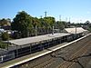
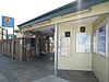
Oak Flats railway station is a single-platform intercity train station located in Oak Flats, New South Wales, Australia, on the South Coast railway line. The station serves NSW TrainLink trains travelling south to Kiama and north to Wollongong and Sydney. Together with the Dunmore and later Shellharbour Junction stations, Oak Flats has long served as the rail connection for the coastal suburbs of the City of Shellharbour.
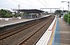
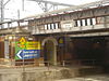
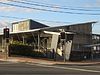
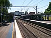
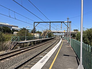
Kembla Grange railway station is a single-platform intercity train station located in Kembla Grange, New South Wales, Australia, on the South Coast railway line. The station serves NSW TrainLink trains travelling south to Kiama and north to Wollongong and Sydney. The station ranked equal last for patronage on the metropolitan network in 2012, and was one of 23 on the metropolitan rail network to record an average of fewer than one passenger per day in 2014.
Lysaghts railway station is an intercity train station located in Spring Hill, New South Wales, Australia, on the South Coast railway line's Port Kembla branch. The station serves NSW TrainLink trains travelling south to Port Kembla and north to Wollongong and Sydney. The station is surrounded on both sides by the Lysaght factory at Spring Hill. Trains only stop on request. There is no way out of the station unless commuters work at the neighbouring steelworks.
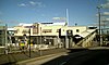
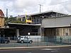
Port Kembla North railway station is a single-platform intercity train station located in Port Kembla, Australia, on the South Coast railway line's Port Kembla branch. The station serves NSW TrainLink trains traveling south to Port Kembla Station and north to Wollongong and Sydney. The station was one of 23 on the metropolitan rail network to record an average of fewer than one passenger per day in 2014.
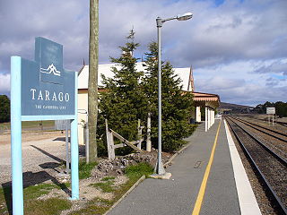
Tarago is a town in the Southern Tablelands of New South Wales, Australia in Goulburn Mulwaree Council. Part of the defined locality, which includes a large area of grazing country, is on the eastern shore of Lake George in the area of the Queanbeyan–Palerang Regional Council. The town is situated 39 kilometres south of the city of Goulburn and 69 kilometres northeast of Canberra, the capital city of Australia. It is located on the Goulburn-Braidwood road. The town is notable for recent renewable energy projects in the surrounding districts.
The Crookwell railway line is a disused branch railway line in the south of New South Wales, Australia. It has never officially been closed. It branched from the Main South line at North Goulburn and passed north through the localities of Kenmore and Roslyn to the town of Crookwell. As of 2020, there were proposals to convert the line into a rail trail.
The Walgett railway line is a railway line in north-western New South Wales, Australia. Opening in 1908, it branches from the North-West Line at Narrabri and passes through the towns of Wee Waa and Burren before ending in the town of Walgett. The line is used for wheat haulage, and the section between the Walgett wheat terminal and Walgett station is closed. There was a proposal to connect the Gwabegar line to the Walgett line at Burren Junction in 1913, and although approved, this connection was never constructed.
The Stockinbingal–Parkes railway line is a railway line in New South Wales, Australia which connects Stockinbingal on the Main South line with Parkes on the Main West line. The line has come to be part of the main route for goods trains travelling between Sydney and the west of NSW and beyond, allowing trains to bypass the steep grades and passenger services on the Blue Mountains section of the Main West line.
The Brewarrina railway line is a closed branch railway line in far-western New South Wales, Australia. It joined the Main West Line at Byrock with the town of Brewarrina on the Darling River. It was 93.67 km long.
Mount Murray is a heritage-listed former railway station in Mount Murray on the Unanderra to Moss Vale railway line in New South Wales, Australia. The station is listed on local and NSW State Heritage Registers as a rare surviving example of small station infrastructure. The platform is located on a passing loop, which is still in use today.
Warialda railway station is a disused railway station 6 kilometres (3.7 mi) SW of Warialda, New South Wales, Australia on the Inverell railway line 481 kilometres (299 mi) NNW of Sydney.
The Queanbeyan railway bridges over Queanbeyan and Molonglo Rivers are two heritage-listed railway bridges that carry the Bombala railway line in the Queanbeyan-Palerang Region local government area of New South Wales, Australia. Both bridges were built between 1926 and 1927. The westernmost bridge crosses the Queanbeyan River from Queanbeyan to Queanbeyan East at 35.3424°S 149.2317°E, while the easternmost bridge crosses the Molonglo River at Burbong at 35.3371°S 149.3191°E. The two railway bridges are owned by Transport Asset Holding Entity, an agency of the Government of New South Wales. Together, the two bridges were added to the New South Wales State Heritage Register on 2 April 1999.