Parramatta Road was first created in 1791, a vital land (cf water) artery between Sydney Cove and Rose Hill's settlement and crops. Liverpool Road opened in 1814 as Governor Macquarie's Great South Road. Its winding route reflects pre-existing land grant boundaries. To Burwood's north over Parramatta was Longbottom Government Farm, staffed by convicts. This grew to over 280 hectares (700 acres) on heavily timbered flat, sloping to swamps on Hen and Chicken Bay. Commissioner Bigge recorded how valuable timber (ironbark) was cut and sawn on the spot, conveyed to Sydney in boats by the river. "Charcoal for the forges and foundries is likewise prepared here" he noted.[3]
Two grants were critical on Burwood's clay: Captain Thomas Rowley's Burwood Farm estate and William Faithful's 400-hectare (1,000-acre) grant to its south in Enfield covered most of modern Burwood. Rowley, adjutant of the NSW Corps, named it after the farm he'd lived on in Cornwall. 1799 and subsequent grants brought it to 300 hectares (750 acres) but he continued to live at Kingston Farm in Newtown until his death in 1806. He'd bought some of the first Spanish merinos brought from the Cape Colony in 1797, others being sold to Macarthur, Marsden & Cox. The southern boundary of his farm was approximately Woodside Avenue & Fitzroy Street.[3]
Under Rowley's will, the estate passed to his three underage children– executors Dr Harris & Major Johnstone were both involved in the 1808 Bligh rebellion and returned to England for the court martial. Governor Macquarie appointed Thomas Moore as guardian and executor. In 1812, he wrongfully auctioned the estate. It was bought by Sydney businessman Alexander Riley. He's believed to have built Burwood Villa in 1814 (perhaps on older (1797) foundations of Rowley's shepherd's cottage) and lived here until departing for England in 1817. In 1824, Joseph Lycett described the estate. 200 hectares (500 acres) had been cleared for pasture. Lycett in Views of Australia described "a garden of 4 acres in full cultivation, containing upwards of three hundred Trees, bearing the following choice fruits, viz. The Orange, Citron, Lemon, Pomegranate, Loquat, Guava, Peaches, Nectarines, Apricots, Apples, Pears, the Cherry, Plums, Figs, Chestnuts, Almonds, Medlars, Quinces; with abundance of Raspberries, Strawberries, and the finest Melons. &c;".[3]
Until the 1830s, Burwood consisted of a few inns along the highways and 2 or 3 huge, undeveloped estates within the next 20 years these began to break up, attracting settlers and encouraging the growth of embryo villages at Burwood & Enfield. Riley died in 1833 and Rowley's children, now of age, started legal proceedings and regained possession of the 304-hectare (750-acre) estate. It was divided between Thomas jnr., John, John Lucas* and Henry Biggs. Almost at once, they subdivided into lots of 2–8 hectares (4–20 acres) for country homes and small farms. In 1834, Burwood estate was held by John Lucas, husband of Thomas's daughter Mary Rowley), who divided 46 hectares (113 acres) of his 86 hectares (213 acres) into small allotments for sale. Streets such as Webb, Lucas Road, Wentworth Road and Strathfield's The Boulevarde reflect the boundaries of these subdivisions/estates.[3]
To the south (including the land later the Appian Way) was William Faithful's grant of 400 hectares (1,000 acres) (1808) at "Liberty Plains". Faithful was a private in the NSW Corps: discharged in 1799 he became Captain Foveaux's farm manager, and this connection got him the grant. Apart from 6.1 hectares (15 acres) of Sarah Nelson's on Malvern Hill (Croydon), Faithful's Farm extended from Rowley's farm to Cooks River and west to Punchbowl Road. The government retained a right to build a road through it (doing so in 1815: Liverpool or the Great South Road), and to cut "such timber as may be deemed fit for naval purposes" – the area was thick with tall ironbark. Faithful exchanged it in 1815. Alexander Riley bought his 200 acres north of the new road incorporating it into his Burwood estate. This was jointly owned by the Rowley family after 1833 and had no streets across it, only a few tracks.[3]
Despite opening up of the Rowley estate, there was little settlement in Burwood between the two highways before 1860. Sydney Railway Company opened the first railway line to Parramatta in 1855. Burwood "station" (just west of Ashfield station, one of the first stations) was a wooden platform near a level crossing over the grassy track that was Neich's Lane* (later Burwood Road). This was beside "the newly laid out township of Cheltenham". Speedy transport meant subdivision and consolidation followed, filling out the area. Burwood's biggest growth spurt was between 1874 & 1900 (Burwood's population was, respectively: 1200–7400, an increase not matched since. *1835 maps show this as the only track between Parramatta / Liverpool Roads in Burwood.[3]
Between 1889 and 1918, Australia's population swelled from three to five million triggering an urgent need for housing. Suburban spread was greatly assisted by expansion of the public transport system of trams, ferries and trams, which formed a well-integrated pre-car transport system.[3][4]
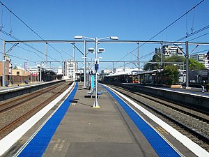
Railway Station Group
Eastbound view from Platforms 5The concourse
The original Burwood station opened on 26 September 1855 at a site at ground level on the west side of Burwood Road.[5][6][7] The station was relocated in 1892 to the current location on the east side of Burwood Road and along Railway Parade when the line was quadruplicated. The line through Burwood was sextuplicated in 1922, and a second subway was constructed at the eastern end of the station.[8] This subway closed after 1985.
Despite opening up of the Rowley estate there was little settlement in Burwood between the two highways before 1860. Sydney Railway Company opened the first railway line to Parramatta in 1855. Burwood "station" (just west of Ashfield station, one of the first stations) was a wooden platform near a level crossing over the grassy track that was Neich's Lane* (later Burwood Rd). This was beside "the newly laid out township of Cheltenham". Speedy transport meant subdivision and consolidation followed, filling out the area. Burwood's biggest growth spurt was between 1874 & 1900 (Burwood's population was, respectively: 1200–7400, an increase not matched since.[4][3]
In 1869, a post office was situated at the railway station. Postal services were previously conducted through general stores. In 1886, a new building was erected at the railway station (this remains today) and in 1892, the present day Post Office, designed by W. L. Vernon, was opened.[9][3]
The surviving building at No. 1 Railway Parade dates from 1886 and was built by the Railway Department fronting the down platform of the then Burwood Station as a Post & Telegraph Office. It survived in its original form until c.1894, when approximately 3/4 of the structure were removed from the southern side facing Railway Parade. It is the last remaining visible fabric of the second Burwood Railway Station which occupied the site immediately west of Burwood Road from 1878 to 1892. Its location coincides approximately with the site of an earlier station building which was erected in 1862 and demolished in 1878. The building is a rare surviving example of a purpose-built post office dating from the years when this facility was often closely associated with the spread and development of the state's railway network... Documentary evidence (historic measured surveys) show that the present building has a different footprint from that standing in 1890 and 1894. An examination of the fabric of the building provides clues to explaining that discrepancy. The present building was erected in 1886, not c.1880 or 1883 as claimed by others. It was purpose built by the Railway Department as a Post and Telegraph Office. Some time after 1894, the building was adapted for a new use as a Railway Goods Office; it may never have been used as a parcels office, even though it was so-named. The present building, and the associated crane and weighbridge, are considered to have local or possibly regional heritage significance.[3]
The four surviving elements in the Burwood Goods Yard – pillar crane, weighbridge, office and platform – are physical reminders of a typical small suburban goods yard at the turn of the 20th century. Few traces of such elements survive at other yards, most if not all of which, such as Petersham and Ashfield, have been closed to goods traffic.[3]
The surviving elements have the ability to be used in assisting in the interpretation of the many changes that have taken place to Burwood Railway Station since the opening of the first platform in 1855.[10][3]
In April 1988, the goods siding to the south of the station was removed.[11]
In 2009–10, the station underwent a significant refurbishment to address high levels of congestion at times of high patronage. Work included an expanded concourse with extra ticket barriers, new toilets and lifts to the platforms.[12] The upgrade was completed in mid 2010.
The complex comprises a brick in subway booking office, completed in 1892; and a brick parcels office that previously served as a railway post office, erected c.1880.[3][16]
Other structures include a brick pedestrian subway and steps; a 5-tonne (6-short-ton; 5-long-ton) jib crane; and a weighbridge, from Goulburn.[3]
Transport links
Transit Systems operates 16 bus routes via Burwood station, under contract to Transport for NSW:
As at 24 November 2000, Burwood is a major suburban site with some significant structures dating from the 1880 period when the railway crossed Burwood Rd by a level crossing. The small former railway post office is a rare surviving example of this type of structure. The Parcels Office is also of significance because it shows the original earlier platform alignment on which the tracks were located and the changes with the upgrading of the line through that area in 1892.[3]
The place possesses uncommon, rare or endangered aspects of the cultural or natural history of New South Wales.
This item is assessed as historically rare. This item is assessed as scientifically rare. This item is assessed as arch. rare. This item is assessed as socially rare.[3]
The Inner West of Sydney is an area directly west of the Sydney central business district, New South Wales, Australia. The suburbs that make up the Inner West are predominantly located along the southern shore of Port Jackson, stretching south to the shores of the Cooks River. The western boundary of the Inner West is approximately the A3 arterial road, which divides the Inner West from the Greater Western Sydney region. The Inner West is much larger than the Inner West Council local government area. The Inner West roughly corresponds with the Parish of Petersham and Parish of Concord, two cadastral divisions used for land titles.
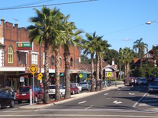
Croydon is a suburb in the Inner West of Sydney, in the state of New South Wales, Australia. It is located 9 kilometres (5.6 mi) west of the Sydney central business district. Croydon is split between the two local government areas of Municipality of Burwood and the Inner West Council.
Burwood is a suburb in the Inner West of Sydney, in the state of New South Wales, Australia. It is 10 kilometres (6.2 mi) west of the Sydney central business district and is the administrative centre for the local government area of Municipality of Burwood.
Bexley North railway station is an Australian transport facility located on the East Hills line, serving the Sydney suburb of Bexley North. It is served by Sydney Trains T8 Airport & South line services.
Strathfield railway station is a heritage-listed railway station located on the Main Suburban line in the Sydney suburb of Strathfield in the Municipality of Strathfield local government area of New South Wales, Australia. The station is served by Sydney Trains T1 North Shore & Western Line, T9 Northern Line and T2 Inner West & Leppington Line suburban services as well as NSW TrainLink Intercity and regional services. The station is located on the Main Northern and Main Western railway lines, forming a major junction for regional and suburban rail services. The station and associated infrastructure was added to the New South Wales State Heritage Register on 2 April 1999.
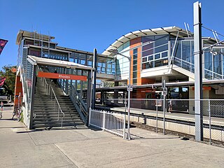
Rhodes railway station is a heritage-listed railway station located on the Main Northern line, serving the Sydney suburbs of Rhodes and Liberty Grove both in City of Canada Bay, Sydney, New South Wales, Australia. It is served by Sydney Trains T9 Northern Line services.
Wentworthville railway station is located on the Main Western line, serving the Sydney suburb of Wentworthville. It is served by Sydney Trains T1 Western and T5 Cumberland line services.
Toongabbie railway station is located on the Main Western line, serving the Sydney suburb of Toongabbie. It is served by Sydney Trains T1 Western and T5 Cumberland line services.
Blacktown railway station is located on the Main Western line, serving the Sydney suburb of Blacktown. It is served by Sydney Trains T1 Western Line and T5 Cumberland Line services and NSW TrainLink Intercity Blue Mountains Line and regional Central West XPT services.
West Ryde railway station is located on the Main Northern line, serving the Sydney suburb of West Ryde. It is served by Sydney Trains T9 Northern Line services.
Ashfield railway station is located on the Main Suburban line, serving the suburb of Ashfield, in Sydney, Australia. It is served by Sydney Trains T2 Inner West & Leppington line services.
Concord is a suburb in the inner West of Sydney, in the state of New South Wales, Australia. It is 10 kilometres (6.2 mi) west of the Sydney central business district, in the local government area of the City of Canada Bay. Concord West is a separate suburb, to the north-west.
Enfield is a suburb in the Inner West of Sydney, in the state of New South Wales, Australia. It is 11 kilometres south-west of the Sydney central business district in the local government area of Municipality of Burwood.
St Marys railway station is a heritage-listed former goods yard, railway signal box and now railway station located on the Main Western line in the western Sydney suburb of St Marys in the City of Penrith local government area of New South Wales, Australia. The station is served by Sydney Trains T1 Western line services. The station marks the end of the four-track section of the Main Western line. It was designed by New South Wales Government Railways and was built in 1862. It is also known as St. Marys Railway Station Group and St Marys Railway Station. The property was added to the New South Wales State Heritage Register on 2 April 1999.
Seven Hills railway station is located on the Main Western line, serving the Sydney suburbs of Kings Langley, Lalor Park, Seven Hills and Seven Hills West. It is served by Sydney Trains T1 Western and T5 Cumberland line services.
Metrobus is a high frequency, high capacity bus network in Sydney, Australia, first introduced in 2008. Metrobus services run every 10 minutes during peak periods, 15 minutes during off-peak weekday periods, and 20 minutes on weekends, linking key commercial suburbs and centres throughout the city, with the intention of making timetables obsolete. All buses were initially painted in a distinctive red livery but recently, the standard Transport for NSW livery of blue and white has been adopted. All Metrobus services are wheelchair accessible. All route numbers were prefixed with an "M" followed by a two-digit number.
The Priory is a heritage-listed residence at 213 Burwood Road, in the Sydney suburb of Burwood in the Municipality of Burwood local government area of New South Wales, Australia. It was built in 1877. The Priory and its grounds was added to the New South Wales State Heritage Register on 2 April 1999.
The Burwood Post Office is a heritage-listed former Aboriginal land, farm and former post office and now retail building located at 168a Burwood Road in the Sydney suburb of Burwood in the Municipality of Burwood local government area of New South Wales, Australia. It was designed by Walter Liberty Vernon and George Oakeshott and built by New South Wales Works Branch. It is also known as Burwood Post Office (former). It was added to the New South Wales State Heritage Register on 18 May 2001.
St Paul's Anglican Church and Pipe Organ is a heritage-listed Anglican church building and pipe organ located at 205 Burwood Road in the Sydney suburb of Burwood in the Municipality of Burwood local government area of New South Wales, Australia. The church was designed by Edmund Blacket and the organ was designed by William Davidson, with some consultation from Montague Younger. The church and organ were built from 1889 to 1891. The church is also known as St. Paul's Anglican Church and Pipe Organ, St Paul's Anglican Church and Davidson Pipe Organ. The property is owned by Anglican Church Property Trust. It was added to the New South Wales State Heritage Register on 2 April 1999.
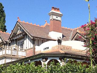
Lynton is a heritage-listed residence located at 4 Clarence Street in the Sydney suburb of Burwood in the Municipality of Burwood local government area of New South Wales, Australia. It was designed by Stanley Rickard and built from 1906. It was added to the New South Wales State Heritage Register on 2 April 1999.
Dunlop, Eric (1975). Harvest of the years – the history of Burwood, 1874-1975.
Fraser, Hugh; Clements, Phillip; Powell, Helen; Read, Stuart (1984). Conservation of the Federation House, a series of one-day seminars, 1981, 1982, 1983, 1984.
Irving, Robert; Pratten, Christopher (1996). No.1 Railway Parade, Burwood – the former Burwood Post & Telegraph Office (later Railway Goods Office) Conservation Plan.
Stations and services in italics are planned or under construction
Stations in (parentheses) are uncommon stops for the listed service
This page is based on this Wikipedia article Text is available under the CC BY-SA 4.0 license; additional terms may apply. Images, videos and audio are available under their respective licenses.