Carlingford railway station

Last updated

Carlingford
Closed commuter rail station
Carlingford Line- Carlingford.jpg
Southbound view in December 2019
General information
LocationLloyds Avenue, Carlingford
Australia
Coordinates 33°46′56″S151°02′49″E / 33.782157°S 151.046962°E / -33.782157; 151.046962
Elevation104m/341ft
Owned by Transport Asset Holding Entity
Operated by Sydney Trains
Line(s) Carlingford
Distance27.85 kilometres from Central
Platforms1
Tracks1
ConnectionsBus
Construction
Structure typeGround
Parking22 spaces
AccessibleYes
Other information
StatusDemolished
Station code CGF
History
Opened20 April 1896
Closed5 January 2020
ElectrifiedYes
Previous namesPennant Hills
Passengers
2018760 (daily) [1] (Sydney Trains, NSW TrainLink)
Former services
Preceding station TfNSW T.png Sydney Trains Following station
Terminus Carlingford Line (1885–2020) Telopea
towards Clyde

Carlingford railway station was a railway station in Sydney, Australia. It opened in 1896 and was the terminus of the Carlingford line, which served the suburb of Carlingford and was served by Sydney Trains T6 Carlingford line services. The Carlingford railway line was closed on 5 January 2020 with the station demolished in May 2020. [2] [ better source needed ]

Contents

History

Carlingford station was built as the terminus of a new privately owned railway from Rosehill. The Cumberland Argus and Fruitgrowers' Advocate of 12 January 1895 described the plans for the station:

The stations will also be first-class structures. At Cox's at Carlingford there will be approaches to the station on two sides. On the right hand side travelling north will be the main station building, and a covered platform 300 feet long. On the left hand side will be a goods siding. ... All the buildings will be of weatherboard. The plans are all ready, but tenders have not yet been accepted. [3]

The station opened on 20 April 1896 as Pennant Hills, but the line was never used, as the owner had got into financial difficulty. Pennant Hills was supposed to be a temporary terminus, as it was originally intended to extend the line to Dural. [4] [5] The initial section of line was eventually taken over and upgraded by the government. It opened for traffic on 1 August 1901 and the Pennant Hills station was renamed Carlingford. [6] [7] After the government took control of the line, it directed the Public Works Committee to conduct an investigation into the value of the Dural extension. The committee ultimately decided not to support construction of the extension. [8]

The Carlingford Produce Store is located adjacent to the station. It included facilities to load grain onto railway wagons. Some of this infrastructure is still extant today. [9] A large amount of land lies behind the station, originally reserved for future extensions of the line.

The brick building on the platform was built in 1978 after the original steam era structure was destroyed by fire. [10]

A major development of Carlingford station – and the Carlingford line – was proposed as part of the Parramatta to Chatswood Rail Link project. The Epping to Parramatta section of the project was postponed indefinitely in 2003 by then-New South Wales Transport Minister Michael Costa citing a lack of projected passenger numbers and economic viability. [11]

However, on 11 August 2010, the federal Labor Party promised $2.6 billion towards a revival of the project, as part of the party's successful campaign to retain government at that year's election. Carlingford would have been rebuilt as an underground station. Work was due to start in 2011, with a prospected 2017 finish, but the NSW Liberal Government cancelled the project, instead requesting that Federal funding be diverted to an upgrade of the Pacific Highway. [12] The Federal Government responded by revoking the funding altogether. [13]

Platforms and services

Carlingford station had the following services:

PlatformLineStopping patternNotes
1Terminating services to and from Clyde [14]

Hillsbus operated one bus route via Carlingford station:

State Transit operated three bus routes via Carlingford station:

Carlingford station was served by one NightRide route:

Related Research Articles

<span class="mw-page-title-main">Carlingford, New South Wales</span> Suburb of Sydney, New South Wales, Australia

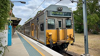
Carlingford is a suburb of Sydney, in the state of New South Wales, Australia. Carlingford is 22 kilometres north-west of the Sydney central business district in the local government area of City of Parramatta. Carlingford sits at the meeting point of Northern Sydney and Western Sydney sitting on both sides of Pennant Hills Road which generally acts as a divider of the two regions. While being part of City of Parramatta, it is sometimes referred to as being part of the Hills District.

Dundas is a suburb of Sydney, New South Wales, Australia. Dundas is located 21 kilometres north-west of the Sydney central business district, in the local government area of the City of Parramatta, and the electoral division of Bennelong. Dundas is a leafy green suburb, notably due to its centrepiece The Ponds Walk, which follows the Ponds Subiaco Creek. Dundas is part of the Northern Sydney and Greater Western Sydney regions.

<span class="mw-page-title-main">Dundas railway station, Sydney</span> Former railway station in New South Wales, Australia

Dundas railway station, originally Kissing Point Road railway station, is a heritage-listed former railway station in Sydney, Australia, that was open between 1896 and 2020 and was located on the Carlingford line, serving the suburb of Dundas.

<span class="mw-page-title-main">Rosehill railway station</span> Former railway station in Sydney, Australia

Rosehill railway station was a railway station in Sydney, Australia that was located next to Rosehill Gardens Racecourse. It was open between 1888 and 2020. It served passengers on the Sandown railway line until 1991, the Carlingford Line until 2020, and special event services to the racecourse, as well as serving the local suburb of Rosehill.

<span class="mw-page-title-main">Wentworthville, New South Wales</span> Suburb of Sydney, New South Wales, Australia

Wentworthville is a suburb in Sydney, in the state of New South Wales, Australia. Wentworthville is located 27 kilometres west of the Sydney central business district and is part of the Greater Western Sydney region. Wentworthville is split between the local government areas of the City of Parramatta and the Cumberland Council. Wentworthville is colloquially known as 'Wenty'.

<span class="mw-page-title-main">Lidcombe railway station</span> Railway station in Sydney, New South Wales, Australia

Lidcombe railway station is located on the Main Suburban line, serving the Sydney suburb of Lidcombe. It is served by Sydney Trains T1 Western, T2 Inner West & Leppington, T3 Bankstown and T7 Olympic line services.

<span class="mw-page-title-main">Camellia railway station</span> Former railway station in Sydney, Australia

Camellia railway station, originally Subiaco railway station, was a railway station in Sydney, Australia, that was open between 1885 and 2020. It was located on the Carlingford line, serving the suburb of Camellia and at the time of closure was served by Sydney Trains T6 Carlingford line services.

<span class="mw-page-title-main">Rydalmere railway station</span> Former railway station in Sydney, Australia

Rydalmere railway station, originally Victoria Road railway station, was a railway station in Sydney, Australia that was open between 1896 and 2020. It was located on the Carlingford line and served the suburb of Rydalmere. At the time of closure, Rydalmere station was served by Sydney Trains T6 Carlingford line services.

<span class="mw-page-title-main">Telopea railway station</span> Former railway station in Sydney, New South Wales, Australia

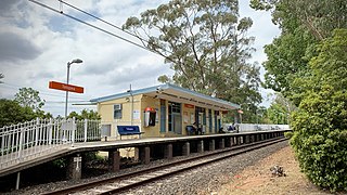
Telopea railway station was a railway station in Sydney, Australia, that was opened in 1925. It is located on the Carlingford line, and served the suburb of Telopea. It was served by Sydney Trains T6 Carlingford line services. The Carlingford railway line closed on 5 January 2020, and the station was demolished in May of that year

<span class="mw-page-title-main">Parramatta railway station</span> Railway station in Sydney, New South Wales, Australia

Parramatta railway station is a heritage-listed railway station located on the Main Western line, serving Parramatta in New South Wales, Australia. It is served by Sydney Trains T1 Western Line, T2 Inner West & Leppington and T5 Cumberland Line services and NSW TrainLink Blue Mountains Line, Central West XPT and Outback Xplorer services.

<span class="mw-page-title-main">Telopea, New South Wales</span> Suburb of Sydney, New South Wales, Australia

Telopea is a suburb of Greater Western Sydney, in the state of New South Wales, Australia. Telopea is located 23 kilometres north-west of the Sydney central business district, in the local government area of the City of Parramatta. The suburb is bordered by Kissing Point Road to the south and Pennant Hills Road to the north.

<span class="mw-page-title-main">Clyde railway station, Sydney</span> Railway station in Sydney, New South Wales, Australia

Clyde railway station is located on the Main Suburban line, serving the Sydney suburb of Clyde. It is served by Sydney Trains T1 Western and T2 Inner West & Leppington line services.

<span class="mw-page-title-main">Pennant Hills Road</span> Highway in Sydney, Australia

Pennant Hills Road is a 16.1-kilometre-long (10.0 mi) arterial road located in Sydney, New South Wales, Australia. The road links the suburb of Wahroonga in the northeast, to the major central business district of Parramatta in the southwest. Apart from a small section at its southwestern end, it is a constituent part of Cumberland Highway, and is designated part of route A28.

<span class="mw-page-title-main">Hillsbus</span> Bus company

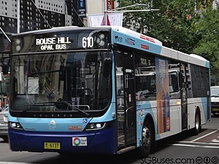
Hillsbus was an Australian bus company that operated services in the Hills District of Sydney. Founded in 2004 when National Express merged its Glenorie Bus Company and Westbus subsidiaries, it was later part of ComfortDelGro Australia. In early 2023, the Hillsbus brand was replaced by ComfortDelGro's CDC NSW brand.

<span class="mw-page-title-main">Buses in Sydney</span> Bus networks in Sydney, Australia

Buses account for close to six per cent of trips each day in the city of Sydney, New South Wales, Australia, forming a key part of the city's public transport system. The network initially evolved from a privately operated system of feeder services to railway stations in the outer suburbs, and a publicly operated network of bus services introduced to replace trams in the inner suburbs. The bus network has undergone major reforms since the 2000s–2010s, with the New South Wales Government taking responsibility for route and fare-setting, opening contracts for most routes up to competitive tendering, and introducing more cross-suburban services.

<span class="mw-page-title-main">Sandown railway line</span> Defunct railway line in Sydney

The Sandown Line is a short former industrial railway line in the western suburbs of Sydney, New South Wales, Australia. It began life as the Bennett's Railway, opening on 17 November 1888. The line diverges from the Carlingford line just south of Camellia station.

<span class="mw-page-title-main">James Ruse Drive</span> Road in Sydney, Australia

James Ruse Drive is a 6.4-kilometre-long (4.0 mi) limited-access urban highway located to the east and north of Parramatta, in Western Sydney, New South Wales, Australia. Originally a series of disconnected urban streets, it was later upgraded to act as a bypass of central Parramatta.

<span class="mw-page-title-main">Harris Park Transport</span>

Harris Park Transport was an Australian bus company operating services in the Hills District and Southern suburbs of Sydney.

<span class="mw-page-title-main">Carlingford railway line</span> Former railway line in Sydney, New South Wales, Australia

The Carlingford railway line was a railway line in Sydney, New South Wales, Australia. It was opened from Clyde to Subiaco in January 1885, then by means of the construction of a bridge across the Parramatta River, to Carlingford in April 1896. It closed on 5 January 2020 with much of the line to be converted to light rail as part of the Parramatta Light Rail network, while a short section of the line was retained for use by Sydney Trains.

<span class="mw-page-title-main">Parramatta Light Rail</span> Light rail line under construction in Sydney

The Parramatta Light Rail is a 12-kilometre (7 mi) standard gauge light rail line currently under construction in Sydney, New South Wales, Australia.

References

  1. Transport Performance and Analytics (21 December 2018). "Train Station Entries and Exits 2016 to 2018". Train Station Entries and Exits Data. Open Data: Government of New South Wales. Archived from the original on 6 August 2023. Retrieved 2 May 2020.
  2. "T6 Carlingford Line closure for Parramatta Light Rail". Railpage. Retrieved 21 May 2020.
  3. "The Rosehill-Pennant Hills Railway – Steady work going on". The Cumberland Argus and Fruitgrowers' Advocate. 12 January 1895. Retrieved 12 December 2016.
  4. "Notification of resumption of land under Simpson's Railway Act of 1893". New South Wales Government Gazette. 10 April 1894. p. 2363. Retrieved 13 December 2016.
  5. "The Rosehill-Dural Railway". The Cumberland Argus and Fruitgrowers' Advocate. 24 March 1894. Retrieved 13 December 2016.
  6. "Carlingford Railway". The Town and Country Journal. 10 August 1901. Retrieved 12 December 2016.
  7. Carlingford Station NSWrail.net
  8. "Carlingford-Dural Railway – the proposal rejected". The Cumberland Argus and Fruitgrowers' Advocate. 20 February 1904. Retrieved 13 December 2016.
  9. "Carlingford Produce Store". Office of Environment & Heritage. Retrieved 13 December 2016.
  10. March 2020 Railway digest ISSN 0157-2431
  11. Big-ticket items go as Costa redrafts transport blueprint Sydney Morning Herald 22 August 2003
  12. Johnson, Stephen (13 June 2012). "Pacific Hwy should trump rail: O'Farrell". The Sydney Morning Herald. Retrieved 17 July 2013.
  13. Aston, Heath (29 May 2013). "Missing link: PM axes $2b Parramatta plan". The Sydney Morning Herald. Retrieved 17 July 2013.
  14. "T6: Carlingford line timetable". Transport for NSW.
  15. "Hillsbus route 625". Transport for NSW.
  16. "State Transit route 513". Transport for NSW.
  17. "State Transit route 546". Transport for NSW.
  18. "State Transit route 550". Transport for NSW.
  19. "N61 Nightride". Transport for NSW.