
Australia's Highway 1 is a network of highways that circumnavigate the country, joining all mainland capital cities except the national capital of Canberra. At a total length of approximately 14,500 km (9,000 mi) it is the longest national highway in the world, surpassing the Trans-Siberian Highway and the Trans-Canada Highway. Over a million people traverse some part of the highway network every day.

Landsborough Highway is a highway in western Queensland, Australia, running in the northwest–southeast direction from Morven to Cloncurry. The Landsborough Highway runs through vast tracts of land that was once occupied by William Landsborough, an Australian explorer of the 19th century. It is also the central part of the tourist route known as the Matilda Way after the popular Australian song Waltzing Matilda, which extends from Bourke in central northern New South Wales to Karumba on the Gulf of Carpentaria.

The Captain Cook Highway is a short, regional highway in Queensland which originates in Cairns and terminates in Mossman, where it joins Mossman-Daintree Road, continuing to Daintree. It is a state-controlled regional road.

The Kennedy Highway is a highway in northern Queensland, Australia. It runs as National Route 1 for approximately 243 km from Smithfield, on the northern outskirts of Cairns, to the Gulf Developmental Road in the vicinity of Forty Mile Scrub and Undara Volcanic national parks. South of this junction, the road continues as the Kennedy Developmental Road to Boulia about 936 kilometres away, via Hughenden. West of the junction, National Route 1 continues as the Gulf Developmental Road to Normanton.

The Isis Highway is a state highway in southern Queensland, Australia. The highway is relatively short, and runs for 137 kilometres (85 mi) in a north-east / south-west direction between Bundaberg North and the Burnett Highway at Ban Ban Springs. The Isis Highway links the sugar producing Bundaberg and Fraser Coast regions with the cattle farming districts of the North Burnett.

The Palmerston Highway, serves as a link between the southern part of the Atherton Tablelands and the Far North Queensland coastal strip, in Australia. Starting just north of Innisfail, from the Bruce Highway it winds through the Wooroonooran National Park to the township of Millaa Millaa, with no major road junctions. It terminates at an intersection with Old Palmerston Highway and Main Street. Its total length is 54.6 kilometres. From here State Route 25 continues west and then north as Malanda-Millaa Millaa Road, while Old Palmerston Highway continues south and then west as a Tourist Drive to where it meets the Kennedy Highway north of Ravenshoe.

Gulf Developmental Road is an Australian highway linking the Cairns and Normanton regions in northern Queensland, Australia. It is the only sealed (asphalt) road linking these two regions.
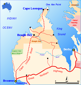
The Cape Leveque Road is a regional Western Australian road that runs through pindan woodland for 205 kilometres (127 mi) between Broome and Cape Leveque on the Dampier Peninsula.

The Gillies Highway is a road that runs from Gordonvale in the Cairns Region through the Gillies Range to Atherton in the Tablelands Region, both in Queensland, Australia. Its official name is Gillies Range Road, and it was originally known as the Cairns Range Road.
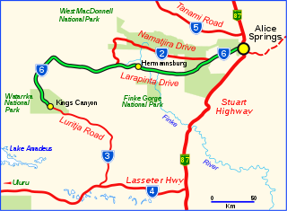
Larapinta Drive is a designated state route in the Northern Territory of Australia.
Main Roads Western Australia controls the major roads in the state's Kimberley region. Great Northern Highway is the major road connection through the region, with sealed roads spurring off it to connect to population centres, and unsealed roads offering an alternative route between Derby and Wyndham.

State Strategic Touring Routes (SSTR) are road routes in Queensland, Australia, which have been identified as significant to motoring tourists. These are the primary routes used by tourists as they provide the connections between popular tourist locations, and consequently have high volumes of tourist traffic. Standardised road signage is used to identify the route itself, with "Welcome to" signage at towns and districts of interest to tourists, as well as "turn off" signage to natural attractions.
The Leichhardt Way is an Australian road route from Melbourne, Victoria to Rockhampton in Queensland. It has been designated by the Queensland Government as a State Strategic Touring Route.
The Great Inland Way is an Australian road route from Sydney, New South Wales to Cairns in Queensland. It has been designated by the Queensland Government as a State Strategic Touring Route.
The Matilda Way is an Australian road route from Bourke, New South Wales to Karumba in Queensland. It has been designated by the Queensland Government as a State Strategic Touring Route.
The Overlanders Way is an Australian road route from Townsville in Queensland to Tennant Creek, Northern Territory. It has been designated by the Queensland Government as a State Strategic Touring Route.
The Pacific Coast Way is an Australian road route from Sydney, New South Wales to Cairns in Queensland. It has been designated by the Queensland Government as a State Strategic Touring Route.
Stanthorpe–Texas–Inglewood Road is a continuous 152.8 kilometres (94.9 mi) road route in the Southern Downs and Goondiwindi regions of Queensland, Australia. It has two official names, Stanthorpe–Texas Road and Inglewood–Texas Road. The entire route is signed as State Route 89. Tourist Drives 5 (Amiens) and 8 and the Shearer’s Way all start in Stanthorpe and run concurrent with this road for part of its length.


