
Ratnagiri District is a district in the state of Maharashtra, India. The administrative headquarter of the district is located in the town of Ratnagiri. The district is 11.33% urban. The district is bounded by the Arabian Sea to the west, Sindhudurg district to the south, Raigad district to the north and Satara, Sangli and Kolhapur districts to the east. This district is part of Konkan division.

Chandrapur district is a district in the Nagpur Division in the Indian state of Maharashtra. Chandrapur was the largest district in India until the Gadchiroli and Sironcha tehsils were separated as Gadchiroli district in 1981. In 2011, the district population was 2,204,307.
Beed district is an administrative district in the state of Maharashtra in India. The district headquarters are located at Beed. The district occupies an area of 10,693 km² and has a population of 2,585,049 of which 17.91% were urban.

Gondia district is an administrative district in the state of Maharashtra in India. The district headquarter is located at Gondia. The district occupies an area of 5,234 km2 (2,021 sq mi) and has a population of 1,322,507 of which 11.95% were urban. The district is part of Nagpur Division. There are 8 Talukas in Gondia District. Gondia Airport is second airport in Vidharbha region and serves city of Gondia.

Narmada district is an administrative district in the state of Gujarat in India. The district headquarters are located at Rajpipla. The district is bounded by Vadodara and Chhota Udaipur districts in the north, by Nandurbar district of Maharashtra state in the east, by Surat and Tapi districts in the south and by Bharuch district in the west. The district occupies an area of 2,755 km² and has a population of 590,297. It was 10.44% urban as of 2011. As of 2011, it is the third least populous district of Gujarat, after Dang and Porbandar.

Belagavi district, formerly known as also Belgaum district, is a district in the state of Karnataka, India. The district is known as Sugar Bowl of Karnataka with 1.5 lakh (150,000) hectares being used for commercial production and it has displaced Mandya district in sugar cane production over the last decade. The city of Belagavi is the district headquarters in North Karnataka. It houses the second legislative building, where the Karnataka Legislature will meet once a year. A popular sweet is kunda. According to the 2011 Census of India, it has a population of 4,779,661, of which 24.03% live in urban areas, making it the second most populous district in Karnataka, after Bangalore. The district has an area of 13,415 km2 (5,180 sq mi) making it the largest district in Karnataka, and is bounded by Kolhapur District and Sangli district of Maharashtra state on the west and north, on the northeast by Bijapur district, on the east by Bagalkot district, on the southeast by Gadag district, on the south by Dharwad and Uttara Kannada districts, and on the southwest by the state of Goa.

Akola district is a district in the Indian state of Maharashtra. The city of Akola is the district headquarters. Akola district forms the central part of Amravati Division, which was the former British Raj Berar Province.

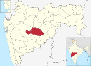
Sangli district is a district of Maharashtra state in India. Sangli city is the district headquarters. It is bordered by Satara district, Solapur district to the North, Karnataka state to South-East, by Kolhapur district to South-West and by narrow portion in East side to Ratnagiri district. It is present on the southern tip of Maharashtra.

Solapur District is a district in Maharashtra state of India. The city of Solapur is the district headquarters. It is located on the south east edge of the state and lies entirely in the Bhima and Seena basins. The entire district is drained by the Bhima River.
Vita, also known as Vite, is a city and a municipal council in Sangli district in the Indian state of Maharashtra. Vita is also taluka headquarters of Khanapur taluka.
Palus is a city and municipal council in sangli district. Palus is developed city in Sangli district. City have best industrial zone, steel firms, foundries and Precision Machine shop.

Tapi district is one of the 33 districts of Gujarat state in western India. It has seven talukas Vyara, Songadh, Nizar, Valod, Uchhal, Dolavan, Kukarmunda. Vyara town is the district headquarters. Tapi has 523 villages and two municipalities. The district was formed in 2007 out of some talukas that were separated from Surat district.
Walwa is a taluka in Sangli district in the Indian state of Maharashtra. It is also known as Walwa-Islampur Taluka. There are ninety-five panchayat villages in Walwa Taluka.
Jat is a town and taluka headquarters in Miraj subdivision of Sangli district in southern Maharashtra.
Kadegaon is a village and taluka of Sangli district of Maharashtra in India.
Atpadi is a taluka in Sangli district of Maharashtra, in 2022 it is one of the talukas of the district, belonging to the Vita sub-division of the district. In 2012 the taluka suffered a severe drought, reportedly the worst in living memory, similar conditions were faced in 2016 and 2019, in 2020 the taluka was hit by floods that caused losses to lives and properties. India's best quality pomegranates are grown in the taluka and the taluka is a pioneer amongst exporters of the fruit, though adverse climatic conditions and diseases have hit the growers. There is a proposal and demand that Sangli district be split to form a new Mandesh district, with Atpadi taluka being one of the talukas to be included in this new district.
Bhood is a village in Khanapur tehsil of Sangli district in Maharashtra, India. It is located near the city Vita.
Lengre is a village in Khanapur (Vita) taluka of Sangli district of Maharashtra in India.
Devikhindi is a village in Khanapur (Vita) taluka of Sangli district of Maharashtra in India. It belongs to Desh or Paschim Maharashtra region. It is situated 21km away from sub-district headquarter Vita and 75km away from district headquarter Sangli. As per 2009 stats, Devikhindi village is also a gram panchayat.
Balawadi is a village located in Khanapur (Vita) Taluka, Sangli District of Maharashtra, India.

