Sangli is a metropolitan town and the headquarters of Sangli District in Maharashtra, in south-western India. It has earned the nickname "Turmeric City of India" for being the hub of the Asia's largest production and trade of this spice. Sangli is situated on the banks of river Krishna and houses many sugar factories. A significant city in South-Western India, it lies 376 km from Mumbai, 230 km from Pune and 638 km from Bangalore. The city has a significant healthcare hub, including its twin City Miraj. Sangli-Miraj combined has more than 1000+ Hospitals and Clinics. Sangli is known as Turmeric city for its global turmeric trade as well grapes, raisins, jaggery and the most significant number of sugar factories in India, with district area having has more than 30 sugar factories.The Sangli region boasts the largest raisin market in Asia. Sangli-Miraj-Kupwad municipal corporation (SMKMC) along with its Urban Agglomeration consisting satellite towns of Madhavnagar & Budhgaon is 93rd biggest in India.
Kirloskarvadi is India's second oldest industrial township that developed around the Kirloskar Brothers Ltd factory in the Palus, Sangli district, in Maharashtra state, India. It is the second oldest industrial township in India. On 10 March 2010, Kirloskarvadi celebrated 100 years of its establishment. Kirloskarvadi is a rapidly growing satellite suburb of Palus city. The famous holy place of God Datta Maharaj Audumbar is just 10 km away. While Sagareshwar picnic spot is around 8–10. The town has centric connectivity between Satara-Sangli-Kolhapur
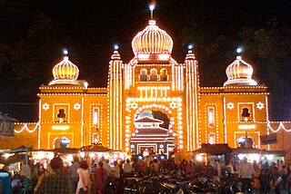
Pandharpur is a popular pilgrimage town, on the banks of Chandrabhagā River, near Solapur city in Solapur District, Maharashtra, India. Its administrative area is one of eleven tehsils in the District, and it is an electoral constituency of the state legislative assembly. The Vithoba temple attracts about a million Hindu pilgrims during the major yātrā (pilgrimage) in Ashadha (June–July).

Amravati district is a district of Maharashtra state in central India. It is the administrative headquarter of Amravati division, which is one of the two divisions in Vidarbha, out of total 6 regions in state of Maharashtra.
Murtijapur is a Municipal council and one of the taluka of district of Akola of the Amravati division of the Vidarbha region of Maharashtra.
Kolhapur district is a district in the Maharashtra state of India. The city of Kolhapur is its district headquarter. It is situated near Panchaganga river.

Hingoli is a city and a municipal council in Hingoli district in the Indian state of Maharashtra

Sangli district is a district of Maharashtra state in India. Sangli city is the district headquarters. It is bordered by Satara district, Solapur district to the North, Karnataka state to the South-East, by Kolhapur district to South-West and by narrow portion on the East side to Ratnagiri district. It is present on the southern tip of Maharashtra.
Daund is a city, municipal council, and headquarters of the Daund tehsil in the Pune district in the state of Maharashtra, India. The city of Daund is located on the Bhima River.
Tasgaon is a city in Maharashtra and Taluka in Sangli district in the Indian state of Maharashtra. Tasgaon city is developing city in Maharashtra. Tasgaon was given as Jahagir to Parshuram Bhau Tasgaonkar by Narayanrao Ballal Peshwa in 1774. Tasgaon Sansthan was lapsed by British during ruling of Shrimant Ganpatrao Tasgaonkar.
Vita, also known as Vite, is a town and a municipal council in Sangli district in the Indian state of Maharashtra. Vita is also taluka headquarters of Khanapur taluka.

Latur is a city in the Indian state of Maharashtra, and is one of the largest cities of the Marathwada region. It is the administrative headquarters of Latur district and Latur Taluka. The city is a tourist hub surrounded by many historical monuments, including Udgir Fort and Kharosa Caves. The people in Latur are called Laturkar. The most spoken language in Latur is Marathi. The city's quality of education attracts students from all over Maharashtra. It is a drought prone area with acute water shortage in its city and rural areas. The economy is agriculture intensive, but in recent years is also dependent on Educational sector & its allied activities. Industrial development is minimal in the district. Latur is 43 kilometers from the epicenter of the devastating 1993 Latur earthquake.
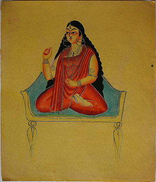
Bhuvaneshvari is a Hindu goddess. She is the fourth amongst the ten Mahavidya goddesses in Shaktism, and one of the highest aspects of Mahadevi. She is identified as Adi Parashakti in the Devi Bhagavata Purana.
Kadegaon is a village and taluka of Sangli district of Maharashtra in India.

Parner taluka is a taluka in Ahmednagar district in the state of Maharashtra in western India.
Bhilawadi is a town which located in palus taluka. it is near about only 16 km from Palus city. Bhilawadi, located on the bank of Krishna River. This town is one of the prominent producers of Grapes and Sugar Cane in Sangli district. Bhilawadi town has won the Nirmal Gram Purskar in Sant Gadage Baba Gram Swachhata Abhiyan.
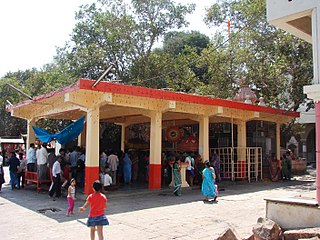
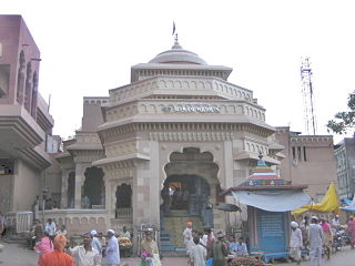
Shree Kshetra Audumbar is in Palus Taluka, it is about only 12km from Palus city, 15km from Kirloskarvadi and 8 Kilometers east from Bhilawadi Railway station, audumbar is known for the shrine of Shree Dattatraya held in high reverence. It is said to have been built in honor of Shree Narasimha Saraswati who is supposed to be the second incarnation of Shree Dattatraya.
Kundal is a town in Palus Taluka within the Sangli District of southwestern Maharashtra, India. It has a population of 18,287 people - 9,432 males and 8,855 females according to the 2011 census. Kundal is located 40 kilometres north of the district capital, Sangli and 5km from Palus.
Upalavi is a village in the Tehsil tasgaon of Sangli district, Maharashtra, India, about 18 kilometres north of Sangli. It is situated along the Sangli-Tasgaon state highway.
Kirloskarvadi railway station is one of the important railway station in Palus, Sangli district, Maharashtra and on Central Railway line. Station code is KOV. It serves for Kirloskarvadi town and connectivity station for Palus–Tasgaon–Islmapur–Vita-Karad Talukas. The station consists of two platforms with completed electrification. The first electric train is expected to run on this line from Kolhapur to Mumbai by December 2021,trial run is completed on this line. The station is opposite the largest industrial township of Kirloskar Group. Famous Datta Maharaj Holy place Audhumbar is just 11 km away. Sagareshwar Wild Life Sanctuary is just 5 km from Kirloskarvadi station. There are trains to major cities like Pune, Mumbai, Delhi, Ahmedabad, Vadodara, Bhopal, Belgaum, Hubli, Jodhpur, Lonavala, Guntakal, Rajkot, Gandhidham, Goa and Bangalore.

