Belgaum is a city in the Indian state of Karnataka located in its northern part along the Western Ghats. It is the administrative headquarters of the eponymous Belgaum division and Belgaum district. The Government of Karnataka has proposed making Belgaum the second capital of Karnataka, hence a second state administrative building Suvarna Vidhana Soudha was inaugurated on 11 October 2012.

Ponda, also known as Fondya, is a city and a municipal council in the north Goa district of Goa, India. Located in the central area of Goa, Ponda lies 28 km southeast of Panaji, the capital of Goa and 17 km northeast of Margao, the district headquarters. Ponda is also known as "Antruz Mahal" because of the presence of numerous famous temples and rich cultural heritage.

Khanapur is a panchayat town in Belgavi district, Karnataka, India. It is about 26 km from Belagavi. The town is governed by the Khanapur Municipal Council. Khanapur is the headquarters for Khanapur taluk. The town is on the Belgaum-Panaji National Highway, NH 4A. Khanapur is well connected by train and road to important cities in Karnataka, Goa, and Maharashtra. Kannada is the official language but Marathi is widely spoken in the town.

National Highway 67, , is a major National Highway in India. It starts at Ramnagar on NH 748, Belagavi - Panjim Road of Karnataka and ends at Krishnapatnam Port road in Andhra Pradesh.
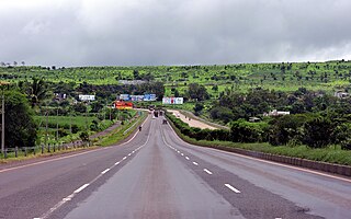
Anmod is a village in Karnataka state of India at the Goa-Karnataka border. Anmod village lies on Belgaum- Goa road route. The Goa state can be reached by descending Anmod Ghat from Karnataka. The NH 748 or 4B highway from Goa up to Goa Karnataka border is good. After that in Karnataka due to incomplete bridge works at many places the road is missing, bad deep pot holes, muddy puddles. If car is stuck or punctured then no vehicular traffic to take help and jungle area with signs of possibilities of animals crossing roads. Best to avoid road. Panaji to Belgaum highway via mollem and anmod ghat road condition. Some of the oldest rocks in the Indian subcontinent are found in Anmod on Goa's border with Karnataka. The rocks are classified as Trondjemeitic Gneiss estimated to be 3,600 million years old, dated by the Rubidium isotope dating method.
National Highway 40, a combination of previous national highways 4 and 18, is a national highway in India. It starts at National Highway 44 junction at Kurnool and passes through Kadapa and Chittoor and terminates at Ranipet in Tamil Nadu. It is called Rayalaseema Express Highway. The highway was transformed into four lanes between Kurnool and Kadapa.

Pondataluka is a subdivision of the district of South Goa, Goa state, India. Its administrative headquarters is the township of Ponda.

Goa is a state on the southwestern coast of India within the Konkan region, geographically separated from the Deccan highlands by the Western Ghats. It is surrounded by the Indian states of Maharashtra to the north and Karnataka to the east and south, with the Arabian Sea forming its western coast. It is India's smallest state by area and its fourth-smallest by population. Goa has the highest GDP per capita among all Indian states, two and a half times as high as the GDP per capita of the country as a whole. The Eleventh Finance Commission of India named Goa the best-placed state because of its infrastructure, and India’s National Commission on Population rated it as having the best quality of life in India. It is the third-highest ranking among Indian states in human development index.
National Highway 69, , is a major National Highway in India, that runs through the states of Karnataka and Andhra Pradesh. The western terminal is at the junction of NH 66 near Honnavar and terminates at the east end at Chittoor.

National Highway 73 is a National Highway in India. This highway runs in the Indian state of Karnataka. It starts from sea port city of Mangaluru ( Mangalore) and ends at Tumakuru. Even though named as national highway the road is narrow and prone to landslips and falling of trees in Charmady ghat section of Western ghats. This highway was previously part of national highways 48, 234 and 206 but subsequent to rationalisation of national highway numbers of India by Gazette notification on 5 March 2010 it was changed to National Highway 73.
National Highway 66, commonly referred to as NH 66, is a 4 lane 1,608 km (999 mi) long busy National Highway that runs roughly north–south along the western coast of India, parallel to the Western Ghats. It connects Panvel to Cape Comorin (Kanyakumari), passing through the states of Maharashtra, Goa, Karnataka, Kerala and Tamil Nadu.

National Highway 75 is one of major National Highway in India. passing through states of Karnataka, Andhra Pradesh, and Tamil Nadu. This national highway was earlier known as National Highway 48 (NH-48) before rationalisation of highway numbers in 2010. NH 48 connected the port city of Mangaluru (Mangalore) to the state capital of Karnataka at Bengaluru. NH-75 traveses all three geographical regions of Karnataka state namely Karavali, Malenadu and Bayaluseeme.
National Highway 167, is a national highway in India, which was formed as a new National Highway by up-gradation and passes through the states of Karnataka, Telangana and Andhra Pradesh. It starts at Hagari in Karnataka and ends at Kodad in Telangana. It is a secondary route of National Highway 67.
National Highway 765, is a National Highway in India, which was formed as a new National Highway by up-gradation and passes through the states of Telangana and Andhra Pradesh. It starts at Hyderabad of Telangana and ends at Tokapelle road of Andhra Pradesh.
National Highway 48 is a National Highway of India that starts at Delhi and terminates at Chennai traversing through seven states of India. It has a total length of 2807 km. NH 48 passes through the states of Delhi, Haryana, Rajasthan, Gujarat, Maharashtra, Karnataka and Tamil Nadu.
National Highway 766C, commonly referred to as NH 766C is a national highway in India. It is a spur road of National Highway 66. NH-766C traverses the state of Karnataka in India.
National Highway 548B, commonly referred to as NH 548B is a national highway in India. It is a spur road of National Highway 48. NH-548B traverses the states of Maharashtra and Karnataka in India.
National Highway 166E, commonly referred to as NH 166E is a national highway in India. It is a spur road of National Highway 66. NH-166E traverses the states of Maharashtra and Karnataka in India.
National Highway 548H, commonly referred to as NH 548H is a national highway in India. It is a spur road of National Highway 48. NH-548H traverses the states of Karnataka and Maharashtra in India.
National Highway 748AA, commonly referred to as NH 748AA is a national highway in India. It is a spur road of National Highway 48. NH-748AA traverses the states of Karnataka and Goa in India.