
The Hooghly River or popularly called Ganga or Kati-Ganga in the Puranas, is a river that rises close to Giria, which lies north of Baharampur and Palashi in Murshidabad. It is the western distributary of the Ganges. The main course of the Ganges then flows into Bangladesh as the Padma. A man-made canal, built in the 1960s and early-1970s at Farakka, connects the Ganges, flowing through Malda, to the Hooghly to bring the abundant waters of the Himalayan river to the comparatively narrow river that rises in eastern West Bengal.

Sealdah Railway Station is one of India's major railway terminals serving the city of Kolkata. The other main railway stations in the Kolkata metropolitan area are Howrah, Shalimar, Kolkata and Santragachi. Over 1.5 million passengers use the station daily. It is an important suburban rail terminal. Kolkata Metro Line 2 passes through Sealdah with the new underground Sealdah metro station.

The Eastern Railway is among the 19 zones of the Indian Railways. Its headquarters is at Fairley Place, Kolkata and comprises four divisions: Howrah, Malda, Sealdah, and Asansol. Each division is headed by a Divisional Railway Manager (DRM). The name of the division denotes the name of the city where the divisional headquarters is located. Eastern Railway oversees the largest and second largest rail complexes in the country, Howrah Junction and Sealdah railway station, and also contains the highest number of A1 and A Category Stations like Howrah, Malda Town, Sealdah, Asansol, Kolkata, Durgapur, Barddhaman, Rampurhat Junction, Bhagalpur,Jamalpur, Jasidih, Bandel and Naihati. Eastern Railways operates India's oldest train, Kalka Mail.

Ranaghat is a city and a municipality in Nadia district in the state of West Bengal, India. It is the headquarters of the Ranaghat subdivision. It is known for its handloom industry, various types of flowers and floriculture.

Raiganj is a city and a municipality in the Indian state of West Bengal. It is the headquarters of the Uttar Dinajpur district. The police station was set up 125 years ago and railway connectivity reached the place 115 years ago. The city houses the 111-year-old Raiganj Coronation High School and more than 50-years-old government primary Raiganj Sarala Sundari GSFP School. Raiganj got its railway connection in 1896. The train used to go to Parbatipur junction in Bangladesh from Raiganj. It is a 200-year-old town.
Berhampore, also known as Baharampur, is a city and a municipality in the state of West Bengal, India. Berhampore is the administrative headquarters of the Murshidabad district. As of 2011 census, Berhampore is the seventh largest city in West Bengal. It is located about 200 km (124 mi) from Kolkata, the state capital.

Krishnanagar is a city and a municipality in the Indian state of West Bengal. It is the headquarters of the Nadia district.
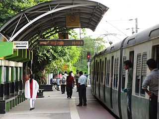
The Kolkata Suburban Railway is a set of suburban and regional rail services serving the Kolkata metropolitan area and its surroundings in India. It is the largest suburban railway network in the country by number of stations and track length, and also one of the largest in the world. There are five main lines and nineteen branch lines. It operates more than 1,500 services, carrying 3.5 million people daily and 1.2 billion people every year. It runs from 03:00 am until 02:00 am and fares range from Rs.5 to Rs.25. The system uses 25 kV 50 Hz AC power supply and runs on 5 ft 6 in broad gauge track. It has interchange stations with the Kolkata Metro at various locations.
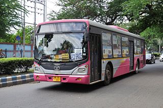
The transport system of Kolkata, a city in India, is a mix of modern mass rapid transport and old transport modalities like rickshaws. Kolkata is connected to the rest of India by the National Highways, the extensive network of the Indian Railways, National Waterways and by air. The most traffic to Northeast India route is via Kolkata.
Rampurhat is a city and a municipality in Birbhum district in the Indian state of West Bengal. It is the headquarters of the Rampurhat subdivision. According to Census 2011 Rampurhat is the third most populous city in Birbhum district and 82nd most populous city in West Bengal. Rampurhat is a rapidly growing township It is near the West Bengal / Jharkhand border. Rampuhat is an important city of Birbhum district as it has dynamic connectivity with the other places of West Bengal and neighboring states via state highways, national highway and rail route. Rampurhat Junction is one of the busiest railway stations in eastern India.

Birati is a locality in North Kolkata North Dumdum of North 24 Parganas district in the state of West Bengal, India. It is a part of the area covered by Kolkata Metropolitan Development Authority (KMDA). This area is very close to the Netaji Subhash Chandra Bose International Airport, which is the busiest airport of West Bengal.
Ashoknagar Kalyangarh is a city and a municipality in Barasat Sadar subdivision of North 24 Parganas district in the state of West Bengal, India. Ashoknagar is the first discovered oilfield in West Bengal and East India. The oilfield was discovered in 2018 by ONGC.

Dankuni is a city and a municipality of Hooghly district in the Indian state of West Bengal. It is now part of the area covered by Kolkata Metropolitan Development Authority (KMDA). It is considered posh area in Hooghly. Positioned strategically near Kolkata, it has emerged as an important industrial and commercial center in the region. The city's landscape is characterized by a mix of residential areas and industrial zones, reflecting its dual identity as a place of habitation and economic activity.

Murshidabad district is a district in the Indian state of West Bengal. Situated on the left bank of the river Ganges, the district is very fertile. Covering an area of 5,341 km2 (2,062 sq mi) and having a population 7.103 million, it is a densely populated district and the ninth most populous in India. Berhampore city is the headquarters of the district.

Old National Highway 2 or Old NH 2, was a major National Highway in India, that connected the states of Delhi, Haryana, Uttar Pradesh, Bihar, Jharkhand and West Bengal. It constitutes a major portion of the historical Grand Trunk Road along with old NH 91 and old NH 1 in India. The highway connects national capital Delhi with Kolkata as well as important cities such as Faridabad, Mathura, Agra, Kanpur, Allahabad, Varanasi, Dhanbad, Asansol, Durgapur and Bardhaman.

Assembly election was held in Indian state of West Bengal in 2011 to elect the members of West Bengal Legislative Assembly as the term of the incumbent government was about to expire naturally. The election was held in six phases between 18 April and 10 May 2011 for all the 294 seats of the Assembly.
South Bengal is a term used for the southern parts of Bengal including Southern Bangladesh and Southern West Bengal, state in India.

Debagram is a village in the Kaliganj CD block in the Krishnanagar Sadar subdivision of the Nadia district in the Indian state of West Bengal.

Kolkata railway station is the newest of the six intercity railway stations serving Howrah and Kolkata, West Bengal, India, the others are Sealdah station in Kolkata and Howrah Junction, Dankuni Junction, Shalimar station and Santragachi Junction on western banks of the Hooghly river. Kolkata station is situated in the Chitpur locality of North Kolkata.


