
Himachal Pradesh is a state in the northern part of India. Situated in the Western Himalayas, it is one of the thirteen mountain states and is characterized by an extreme landscape featuring several peaks and extensive river systems. Himachal Pradesh is the northernmost state of India and shares borders with the union territories of Jammu and Kashmir and Ladakh to the north, and the states of Punjab to the west, Haryana to the southwest, Uttarakhand to the southeast and a very narrow border with Uttar Pradesh to the south. The state also shares an international border to the east with the Tibet Autonomous Region in China. Himachal Pradesh is also known as Dev Bhoomi, meaning 'Land of Gods' and Veer Bhoomi which means 'Land of the Brave'.

Shimla is the capital and the largest city of the northern Indian state of Himachal Pradesh. In 1864, Shimla was declared as the summer capital of British India. After independence, the city became the capital of East Punjab and was later made the capital city of Himachal Pradesh. It is the principal commercial, cultural and educational centre of the state.

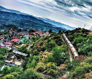
Solan is a city in the Indian state of Himachal Pradesh and the district headquarters of Solan district. It is located 45.5 kilometres (28 mi) south of the state capital, Shimla. Solan has an average elevation of 1,550 metres (5,090 ft). The city is situated between Chandigarh and Shimla on the Kalka-Shimla National Highway-5. The narrow-gauge Kalka-Shimla railway passes through Solan. Located on the Punjab-Himachal Border, Solan is nestled in the Shivalik hills of the Himalayas.

Manali is a town, near Kullu town in Kullu district in the Indian state of Himachal Pradesh. It is situated in the northern end of the Kullu Valley, formed by the Beas River. The town is located in the Kullu district, approximately 270 kilometres (170 mi) north of the state capital of Shimla and 544 kilometres (338 mi) northeast of the national capital of New Delhi. With a population of 8,096 people recorded in the 2011 Indian census Manali is the beginning of an ancient trade route through Lahaul (H.P) and Ladakh, over the Karakoram Pass and onto Yarkand and Hotan in the Tarim Basin of China. Manali is a popular tourist destination in India and serves as the gateway to the Lahaul and Spiti district as well as the city of Leh in Ladakh.

Barog is a hill station, near City of Solan in Solan district in the Indian state of Himachal Pradesh. The station lies on UNESCO World Heritage Site Kalka–Shimla Railway. Set in the mountains Barog is just 60 km from Chandigarh on the Kalka-Shimla highway.
Ghumarwin is a town and a municipal council, near the town of Bilaspur in Bilaspur district in the North Indian State of Himachal Pradesh and is the second largest town of the entire district. The town is an anchor point for commuters between Bilaspur and Hamirpur and other parts of the state. Situated primarily between the Hills of Lower Central Himalayas, Ghumarwin is situated at an average elevation of 700 metres or about 2300 ft. above sea level. It is one of the biggest commercial centres of Bilaspur District and one can find all kinds of shops, stores, services etc. here.
The development of tribal areas in Himachal Pradesh is one of the major steps taken by the state government for its economic development. The border districts of Kinnaur, Lahaul, Spiti and the Pangi and Bharmour tehsils of Chamba districts are the major tribal areas of the state. They are located near the borders of Tibet and Indian States of Jammu and Kashmir. Other backward areas include Shillai in Sirmaur district, and deep cut-off valleys in the Kullu and upper stretches of Kangra districts. Due to poor accessibility, life in these areas had grown in isolation.

Kasauli Brewery and Distillery, at Kasauli in Solan district of Himachal Pradesh state of India, was established in late 1920s during the British Raj by Edward Abraham Dyer - father of "The Butcher of Jallianwala Bagh", Colonel Reginald Edward Harry Dyer. It started producing Asia's first beer brand, the "Lion Beer", and India's first single malt whisky, the ""Solan No. 1". Both of these brands are still in production. After the swap of brewery at Kasauli to Solan distillery and vice versa in 1835, presently Lion beer is produced at Solan and Solan No.1 whisky is produced at the Kasauli distillery using some of the original equipment including the copper pot still. The production of Lion beer was moved 25 km east to Solan Brewery at Solan, due to water scarcity, after civilian Kasauli hill station resort town came up around the brewery. Lion beer was originally an India Pale Ale (IPA), but the beer style was changed to lager in 1960s.

Pinegrove School, established in 1991, in Solan, Himachal Pradesh, India, is a co-educational, purely residential, English medium public school affiliated to the Central Board of Secondary Education(CBSE), Delhi, up to the senior secondary stage.

Dharampur is a town located in Solan district of Himachal Pradesh. It is located in Kasauli tehsil, about 65 km from Shimla and 15 km from Kasauli on the National Highway 22. It is also connected by the Kalka Shimla Railway Line. It houses the first tuberculosis sanatorium in North India. C R.P.F. camp on N.H. 22 on Shimla Road.
Totu is one of the major suburbs of Shimla city, in the state of Himachal Pradesh, India. It is under the administration of the Shimla Municipal Corporation.
Darlaghat is a village panchayat in Solan district in the state of Himachal Pradesh, India. It is famous for its Ambuja Cement plant. It is situated on Darlaghat Mountain ranges of Arki at an altitude ranging from 1,800–2,000 metres (5,900–6,600 ft). Shimla-Bilaspur-Kangra National Highway passes from center of the village. Its name is derived from a fruit called as Daru. Daru grows naturally in the vast tract of mid Himalayan hill slopes of Jammu and Kashmir, Himachal Pradesh and Uttarakhand.

National Highway 3, or NH 3, is a national highway in India. It starts from Atari adjacent to India-Pakistan border and near Amritsar and terminates at Leh in Ladakh, via Manali in Himachal Pradesh.

National Highway 5 (NH5) is a primary national highway in India, running from West to East, connecting Firozpur in Punjab to the Sino-Indian border at Shipki La. The highway passes through Moga, Jagraon, Ludhiana, Mohali, Chandigarh, Panchkula, Kalka, Solan, Shimla, Theog, Narkanda, Kumarsain, and Rampur Bushahr and continues along the Sutlej River till its terminus near the Tibet border.

National Highway 7 is a highway connecting Fazilka (Punjab) to Mana (Uttarakhand) in India. It passes through the Indian states of Punjab, Haryana, Himachal Pradesh, and Uttarakhand.
The key political players in Himachal Pradesh state in north-west India are the Indian National Congress and Bharatiya Janata Party.

National Highway 503, commonly referred to as NH 503, is a highway connecting the city of Dharamshala to Mubarakpur in Himachal Pradesh. NH503 has been extended from Mubarakpur to Kiratpur in Punjab. The route of NH503 is extended from Mataur Kangra to Mcleodganj Dharamshala.

National Highway 105, commonly referred to as NH 105, is a national highway in India running from Pinjore in Haryana to Swarghat in Himachal Pradesh. The highway passes through the states of Himachal Pradesh and Haryana.
National Highway 205A, commonly referred to as NH 205A, is a national highway in India. It is a spur road of National Highway 5. NH-205A traverses the state of Punjab in India.
Ghanauli village is situated near Rupnagar in Rupnagar district in the state of Punjab in India. It was a jagir ruled by Virk Jats.


