New Panvel is a residential, commercial and educational node of Navi Mumbai, Raigad District, Maharashtra and comes under the Konkan division. New Panvel was developed on marshy land and was previously a Mango cultivated area. New Panvel is divided into two parts: New Panvel (E), on the eastern side of Panvel railway station and Khanda Colony or New Panvel (W) on the western side of it. Both parts of New Panvel are connected by a flyover bridge also known as Khanda Colony Flyover. New Panvel (W) is also popularly called Khanda Colony by the local villagers, as the city is adjacent to two small villages Dhakta Khanda and Motha Khanda.

Morigaon district is an administrative district in the state of Assam in India. The district headquarters is located at Morigaon. The ancient place of occult Mayong is located in this district as well as Pobitora Wildlife Sanctuary.

Nagaon district is an administrative district in the Indian state of Assam. At the time of the 2011 census it was the most populous district in Assam, before Hojai district was split from it in 2016.

Nagaon is a town and a municipal board in Nagaon district in the Indian state of Assam. It is situated 122.6 kilometres (76 mi) east of Guwahati.

The North–South–East–West Corridor (NS-EW) is the largest ongoing highway project in India. It is the second phase of the National Highways Development Project (NHDP), and consists of building 7300 kilometers of four/six lane highways associating Srinagar, Kanyakumari, Kochi, Porbandar and Silchar, at a cost of US$12.317 billion. As of 31 March 2018, 6875 of the 7142 kilometers project has been finished.
Jagiroad is a town in the state of Assam. Jagiroad located in Mayong Sub-Division, in Morigaon district. It is situated on the south bank of Kolong river.

Dipor Bil, also spelled Deepor Beel , is located to the south-west of Guwahati city, in Kamrup Metropolitan district of Assam, India. It is a permanent freshwater lake, in a former channel of the Brahmaputra River, to the south of the main river. In 1989, 4.1 km² of the area was declared a wildlife sanctuary by the Government of Assam. It is listed as a wetland under the Ramsar Convention which designated the lake as a Ramsar Site in November 2002 for undertaking conservation measures on the basis of its biological and environmental importance.

Dihing or Burhi Dihing is a large tributary, about 380 kilometres (240 mi) long, of the Brahmaputra River in Upper Assam in northeastern India. The river originates at 2,375 metres (7,792 ft) above sea level in the Eastern Himalayas in Arunachal Pradesh and flows through Tinsukia and Dibrugarh Districts in Assam to its confluence with the Brahmaputra at Dihingmukh. Its watershed covers about 6,000 square kilometres (2,300 sq mi). The Dihing has created number of oxbow lakes in the area.
Lanka is a town located in Hojai District of Assam, and a town area committee with 11 wards. It serves as a trade and commerce hub for nearby areas such as Udali, Nokhuti, Laskar Pather, Karikhana, Kheroni, Dablong, and Doiyong sides. It is connected to other cities/states such as Guwahati by NH27.

Kaziranga National Park is an Indian national park and an UNESCO World Heritage Site situated in the Golaghat and Nagaon district of Assam, India. It is a tourist destination and conservation area particularly notable as a refuge for the endangered Indian one-horned rhinoceros, hosting the largest population of wild Indian one-horned Rhinoceros in the world. The park contains significant stock of three other large herbivores — the Asian Elephant, the Asiatic Water Buffalo and the eastern subspecies of the Swamp Deer. Kaziranga also has the highest density of tiger in the world and is declared a Tiger Reserve in 2006. Kaziranga is recognized as an Important Bird Area by Birdlife International for conservation of avifaunal species.
The Ministry of Development of North Eastern Region is a Government of India ministry, established in September 2001, which functions as the nodal Department of the Central Government to deal with matters related to the socio-economic development of the eight States of Northeast India: Arunachal Pradesh, Assam, Manipur, Meghalaya, Mizoram, Nagaland, Tripura and Sikkim. It acts as a facilitator between the Central Ministries/ Departments and the State Governments of the North Eastern Region in the economic development including removal of infrastructural bottlenecks, provision of basic minimum services, creating an environment for private investment and to remove impediments to lasting peace and security in the North Eastern Region.

Assam is the main and oldest state in the North-East Region of India and as the gateway to the rest of the Seven Sister States. The land of red river and blue hills, Assam comprises three main geographical areas: the Brahmaputra Valley which stretching along the length of the Brahmaputra river, the Barak Valley extending like a tail, and the intervening Karbi Plateau and North Cachar Hills. Assam shares its border with Meghalaya, Arunachal Pradesh, Nagaland, Manipur, Tripura, Mizoram and West Bengal; and there are National Highways leading to their capital cities. It also shares international borders with Bhutan and Bangladesh and is very close to Myanmar. In ancient times Assam was known as Pragjyotisha or Pragjyotishpura, and Kamarupa.
Annanur is a western neighbourhood of Chennai, India. It is located near Ambattur and lies in Chennai District. It comes under the Avadi Municipal Corporation. It is located about 20 km from the city centre.

Silghat is a town located on the southern banks of the Brahmaputra, in Nagaon district in the Indian state of Assam. It is 48 km northeast of Nagaon. With a river and hills, the scenery of Silghat attracts local and visitors throughout the year. Silghat is home to Kamakhya Temple, Trishuldhari, Samantagiri, Simala Garh, Manuh Kata Tumoni, heritage British era bungalows, Gandhi Asthidham, and Sudhakantha Sammanoi Khetra. Every year in March or April (Chot/Bohag), Ashokastami mela is held at Slighat's holy river bank. The Assam Cooperative Jute Mill Ltd. operates in Silghat.
Raha is a small town in Nagaon district of Assam, India, situated near the National Highway 37. The river Kolong and Kopili flows near Raha. Raha is also situated near to Chaparmukh, a small town popularly known for Chaparmukh junction, one of the prominent railway stations in Nagaon district.
The Trans-Arunachal Highway (TAH), which includes an existing 1,811 km (1,125 mi) route comprising NH-13 and parts of NH-15, NH-215 and SH-25, is an under-construction 2-lane more than 2,407 km (1,496 mi) long highway passing through 16 districts in Arunachal Pradesh state in India. It runs from LAC in Tawang in northwest to Kanubari in southeast at tri-junction of Assam-Nagaland-Arunachal Pradesh. It connects at least 16 districts of Arunachal Pradesh.
East-West Industrial Corridor Highway of Arunachal Pradesh, a 2-lane and 966.78 km long including existing 274.20 km Pasighat-Manmao route, is a proposed highway across lower foothills of Arunachal Pradesh state in India from Bhairabkunda in Assam at tri-junction of Bhutan-Assam-Arunachal Pradesh in west to Kanubari tri-junction of Nagaland-Assam-Arunachal Pradesh in east.
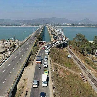
National Highway 27, an East - West National highway in India that starts in Porbandar and ends in Silchar, the highway passes through the states of Gujarat, Rajasthan, Madhya Pradesh, Uttar Pradesh, Bihar, West Bengal, Assam. NH-27 was laid and is maintained by Ministry of Road Transport and Highways (MoRTH). It is the second longest National Highway in India and is a part of NS-EW Corridor of NHAI.

Bhuragaon is the name of a town in the Indian state of Assam. Bhuragaon is located in Morigaon district. The town is situated on the south bank of the river Brahmaputra.
National Highway 127B, commonly called NH 127B is a National Highway in North East India that connects Srirampur in Assam to Nongston in Meghalaya.
2. New Gatanga Town Reference