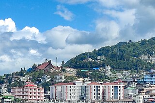
Kohima is the capital city of India's north eastern state of Nagaland. With a resident population of almost 100,000, it is the second largest city in the state. Originally known as Kewhira, Kohima was founded in 1878 when the British Empire established its headquarters of the then Naga Hills District of Assam Province. It officially became the capital after the state of Nagaland was inaugurated in 1963. Kohima was the site of one of the bloodiest battles of World War II. The battle is often referred to as the ‘Stalingrad of the East’. In 2013, the British National Army Museum voted the Battle of Kohima to be ‘Britain's Greatest Battle’.
Dimapur is the largest city in Nagaland, India. As of 2011, the municipality had a population of 122,834. The city is the main gateway and commercial centre of Nagaland. Located near the border with Assam along the banks of the Dhansiri River, Dimapur is the only plains tract of hilly Nagaland and also has the only airport in the state for connectivity and economic activity. Its main railway station is the second busiest station in Northeast India.

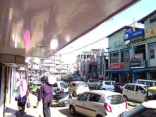
Chümoukedima is a town in the Dimapur District of the Indian state of Nagaland. It is at a distance of 14 km from Dimapur on National Highway 39.
National Highway 122 is a national highway of India. This highway runs entirely in the state of Bihar. It is a spur road of National Highway 22. NH-122 was previously numbered NH-28.

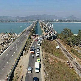
National Highway 2 is a national highway in India that runs from Dibrugarh in Assam to Tuipang in Mizoram. This national highway passes through the Indian states of Assam, Nagaland, Manipur and Mizoram. This national highway is 1,325.6 km (823.7 mi) long. Before renumbering of national highways, NH-2 was variously numbered as old national highways 37, 61, 39, 150 and 54.
National Highway 27, an East - West National highway in India that starts from Porbandar and terminates in Silchar, the highway passes through the states of Gujarat, Rajasthan, Madhya Pradesh, Uttar Pradesh, Bihar, West Bengal, Assam. NH-27 was laid and is maintained by Ministry of Road Transport and Highways (MoRTH). This is the second longest National Highway in India and is a part of NS-EW Corridor of NHAI.
National Highway 45 is a primary national highway in India. This highway runs in the states,sagartola of Madhya Pradesh and Chhattisgarh. The route of NH-45 was extended from Jabalpur to Bilaspur in June 2016.

National Highway 73 is a National Highway in India. This highway runs in the Indian state of Karnataka. It starts from sea port city of Mangaluru ( Mangalore) and ends at Tumakuru. Even though named as national highway the road is narrow and prone to landslips and falling of trees in Charmady ghat section of Western ghats. This highway was previously part of national highways 48, 234 and 206 but subsequent to rationalisation of national highway numbers of India by Gazette notification on 5 March 2010 it was changed to National Highway 73.
National Highway 23 is a primary national highway in India. NH-23 runs in an east-west direction, entirely in the state of Rajasthan.

National Highway 102B, commonly referred to as NH 102B is a national highway in India. It is a spur road of National Highway 2. NH-102B traverses the states of Manipur and Mizoram in India. It is known as Guite road by Gazette Order of the Government of Manipur.
National Highway 702, commonly called NH 702 is a national highway in states of Nagaland and Assam in India. It is an offshoot of primary National Highway 2.
National Highway 702A, commonly called NH 702A is a national highway in states of Nagaland and Manipur in India. It is a branch of primary National Highway 2.
National Highway 702D, commonly called NH 702D is a national highway in states of Nagaland and Assam in India. It is an offshoot of primary National Highway 2. This new highway has been accorded national status to upgrade it to two lanes and provide better movement for defense personnel and goods movement.
National Highway 329, commonly called NH 329 is a national highway in India. It is a spur road of National Highway 29. NH-329 traverses the state of Assam in India.
National Highway 329A, commonly called 329A is a national highway in India. It is a spur road of National Highway 329. NH-329A traverses the states of Assam and Nagaland in India.
National Highway 117A, commonly called NH 117A is a national highway in India. It is a spur road of National Highway 17. NH-117A traverses the state of Assam in India.
National Highway 715A, commonly called NH 715A is a national highway in India. It is a spur road of National Highway 15. NH-715A traverses the state of Assam in India.
National Highway 127E, commonly called NH 127E is a national highway in India. It is a spur road of National Highway 27. NH-127E traverses the state of Assam in India.
National Highway 129A, commonly referred to as NH 129A is a national highway in India. It is a spur road of National Highway 29. NH-129A traverses the states of Manipur and Nagaland in India.
National Highway 137A, commonly referred to as NH 137A is a national highway in India. It is a spur road of National Highway 37. NH-137A traverses the state of Manipur in India.


