
Munger, formerly spelt as Monghyr, is a twin city and a Municipal Corporation situated in the Indian state of Bihar. It is the administrative headquarters of Munger district and Munger Division. Munger was one of the major cities in Eastern India and undivided Bengal during Mughal period and British Raj. It is one of the major political, cultural, educational and commercial center of Bihar and Eastern India. Munger is situated about 180km from east of capital city Patna, about 480km west of Eastern India's largest city Kolkata and 1200km from country's capital New Delhi.

Bihar Sharif is the headquarters of Nalanda district and the fifth-largest sub-metropolitan area in the eastern Indian state of Bihar. Its name is a combination of two words: Bihar, derived from vihara, also the name of the state; and Sharif. The city is a hub of education and trade in southern Bihar, and the economy centers around agriculture supplemented by tourism, the education sector and household manufacturing. The ruins of the ancient Nalanda Mahavihara, a UNESCO World Heritage Site, are located near the city.

Arwal district is one of the thirty-eight districts of Bihar state, India, and Arwal town is the administrative headquarters of this district. It was earlier part of Jehanabad district.
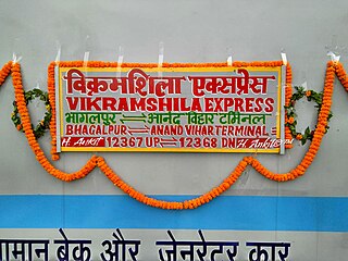
12367 / 12368 Vikramshila Superfast Express is a train service that connects Bhagalpur, one of the largest cities of Bihar to India's capital New Delhi. The train passes through the cities of Kanpur, Mughalsarai, Lakhisarai, Patna, Bakhtiyarpur, Mokama, Kiul Junction and Jamalpur, before ending its journey at Bhagalpur.
Arwal town is the administrative headquarters of Arwal district in Bihar state of India. It was earlier part of Jehanabad district. The district as formed to control the naxalism in the area. District was formed from the area of two near by districts i.e. Jehanabad and Aurangabad. Arwal has a population of 588,000. Arwal, the district headquarters is approximately 80 km south from the state capital Patna. Arwal town is situated on the right side bank of the Sone River, which is a tributary to the Ganges.
National Highway 31, previously known as National Highway 106, is a national highway of India. It starts from Birpur in Supaul district to Bihpur in Bhagalpur district and passes through Madhepura district and terminates at Bihpur in Bhagalpur district of Bihar. It is major Highway of Madhepura district which starts at Birpur, passes through Simrahi, connects National Highway 57, Singheshwar, Madhepura junction to National Highway 231, Reshna, Gwalpara, Udakisunganj, and terminates at Bihpur connects National Highway 31.
National Highway 133, commonly called NH 133 is a national highway in India. It is a spur road of National Highway 33. NH-133 traverses the states of Jharkhand and Bihar in India. The highway is 134 km (83 mi) long. The highway connects Godda in Jharkhand with Pirpainti in Bihar.
National Highway 139 is a national highway in India, which passes through Bihar and Jharkhand. NH-139 connects Medininagar (Daltonganj) in Jharkhand to Phulwari Sharif in Patna, Bihar. This 207-kilometre-long (129 mi) highway passes through Arwal, Daudnagar and Aurangabad.

The Bihar legislative assembly election, 2010 was held in six phases over a period of one month starting from 21 October until 20 November in all 243 constituencies of Bihar, India. The election is conducted to elect the government in Bihar for a five-year term. The votes were scheduled to be counted on 24 November.

Shri Krishna Setu NH 333B is a rail-cum-road bridge across the Ganges, at Munger in the Indian state of Bihar and named after first Chief Minister of Bihar Shri Krishna Singh. The bridge connects the Munger-Jamalpur twin cities in Munger District to various districts of North Bihar. Srikrishna Setu Munger Ganga Bridge is the third rail-cum-road bridge over Ganga in Bihar.
The state of Bihar has a number of bridges, extending from few metres to a few kilometres. The history of long bridges goes back to the British Empire when the site for the Koilwar bridge was surveyed in 1851. Since then a number of small and large bridges have crept up. Some are even largest of their kind. Mahatma Gandhi Setu, joining Patna and Hajipur was India's longest river bridge from 1982 to 2017.

National Highway 31 is a primary National highway of India. It starts in Unnao in Uttar Pradesh, passes through Bihar, and terminates at its crossing with State Highway 10 at Samsi in Malda district of West Bengal. SH 10 (WB) connects Samsi to NH 12.

South Bihar Power Distribution Company Limited (SBPDCL) is a public sector undertaking (PSU) controlled by the Government of Bihar. It was formed on 1 November 2012 under section 14 of the Electricity Act of 2003, and is the successor to the erstwhile Bihar State Electricity Board.
Poraiyahat is a town in the Poraiyahat community division block in the Godda district of Jharkhand, India.

Munger University is a state university and was established on 18 March 2018 through bifurcation of Tilka Manjhi Bhagalpur University, Bhagalpur. The university started operating academically from the 2018–19 academic year.
National Highway 333, commonly referred to as Munger Deoghyr Highway is a national highway in India. It is a spur road of National Highway 33. NH-333 traverses the states of Bihar and Jharkhand in India.

National Highway 333A, commonly referred to as NH 333A is a national highway in India. It is a spur road of National Highway 33. NH-333A traverses the states of Bihar and Jharkhand in India.

National Highway 333B, commonly referred to as Munger Ganga Bridge Road is a national highway in India. It is a spur road of National Highway 33. NH-333B traverses the state of Bihar in India.
Bariarpur is a small town in the Munger district of Bihar state. Bariar (बरियार) means strong, hence Bariarpur means 'a place of the strong'.


