National Highway 27 (India)

Last updated

NH27-IN.svg
National Highway 27
New Saraighat.jpg
New and Old Saraighat bridges
Route information
Part of AH1-IN.svg AH1 AH2-IN.svg AH2 AH20-IN.svg AH20 AH42-IN.svg AH42 AH48-IN.svg AH48
Length3,507 km (2,179 mi)
Major junctions
West end Porbandar, Gujarat
Major intersectionsNH 44 in Jhansi, AH20-IN.svg AH20 Jhansi
East end Silchar, Assam
Location
Country India
States Gujarat, Rajasthan, Madhya Pradesh, Uttar Pradesh, Bihar, West Bengal, Assam
Primary
destinations
Bamanbore - Morvi, Samakhiali - Radhanpur - Palanpur- Abu Road - Pindwara - Udaipur -Bansen - Chittaurgarh, Kota - Baran- Shivpuri - Karera - Jhansi - Kanpur - Lucknow - Barabanki - Ayodhya - Basti - Gorakhpur - Kushinagar - Gopalganj - Chakia - Muzaffarpur - Darbhanga - Jhanjharpur - Forbesganj - Araria - Purnia - Dalkola - Siliguri - Bongaigaon - Rangia - Guwahati - Dispur - Dobaka - Haflong
Highway system
NH51-IN.svg NH 51 NH37-IN.svg NH 37

National Highway 27 (NH 27), an East - West National highway in India that starts in Porbandar and ends in Silchar, the highway passes through the states of Gujarat, Rajasthan, Madhya Pradesh, Uttar Pradesh, Bihar, West Bengal, Assam. [1] NH-27 was laid and is maintained by Ministry of Road Transport and Highways (MoRTH). It is the second longest National Highway (after NH 44) in India and is a part of NS-EW Corridor of NHAI.

Contents

Route

National highway 27 transits across seven states of India in east - west direction. [2] [3]

Gujarat

Porbandar, Kutiyana, Upleta, Dhoraji, Jetpur, Gondal, Rajkot, Bamanbore, Morvi, Samakhiali, Radhanpur, Deesa, Palanpur

Rajasthan

Abu Road, Pindwara, Udaipur, Mangalwar, Chittaurgarh, Kota, Baran

Madhya Pradesh

Shivpuri, Karera

Uttar Pradesh

Jhansi, Orai Kanpur, Unnao, Lucknow, Barabanki, Ayodhya, Basti, Khalilabad, Gorakhpur, Kushinagar, Hata

Bihar

Gopalganj, Motihari, Muzaffarpur, Darbhanga, Jhanjharpur, Supaul, Forbesganj, Araria, Purnia and Kishanganj.

West Bengal

Dalkhola, Islampur, Bagdogra, Siliguri, Jalpaiguri, Mainaguri, Dhupguri, Falakata, Coochbehar, Sonapur, Alipurduar, Kamakhyaguri

Assam

Bongaigaon, Bijni, Howly, Patacharkuchi, Nalbari, Rangiya, Guwahati, Nagaon, Hojai, Lanka, Lumding, Haflong, Silchar

Junctions list

Gujarat
4 lane highway, Gujarat Gujarat India 4 lane highway NH 27 in Saurashtra region.jpg
4 lane highway, Gujarat
NH51-IN.svg NH 51 Terminal near Porbandar
NH927D-IN.svg NH 927D near Dhoraji
NH151-IN.svg NH 151 near Jetpur
NH351-IN.svg NH 351 near Jetpur
NH47-IN.svg NH 47 Interchange near Bamanbore
NH41-IN.svg NH 41 Interchange near Samakhiali
NH68-IN.svg NH 68 near Radhanpur
NH168A-IN.svg NH 168A near Deesa
Rajasthan
NH 27 in Rajasthan Roads India NH 27 highway Rajasthan 2015.jpg
NH 27 in Rajasthan
NH927A-IN.svg NH 927A near Swaroopganj
NH62-IN.svg NH 62 Interchange near Pindwara
NH58-IN.svg NH 58 near Udaipur
NH48-IN.svg NH 48 near Udaipur
NH162-IN.svg NH 162 near Bhatevar (162EXT)
NH48-IN.svg NH 48 interchange near Chittorgarh
NH56-IN.svg NH 56 interchange near Chittorgarh
NH758-IN.svg NH 758 near Ladpura
NH52-IN.svg NH 52 near Kota
NH752-IN.svg NH 752 interchange near Baran
Madhya Pradesh
NH46-IN.svg NH 46 near Shivpuri
Uttar Pradesh
NH 27 & NH 28 shared route near Basti, Uttar Pradesh NH 28.jpg
NH 27 & NH 28 shared route near Basti, Uttar Pradesh
NH44-IN.svg NH 44 near Jhansi
NH552-IN.svg NH 552 near Chirgaon
NH519-IN.svg NH 519 near Bhognipur
NH19-IN.svg NH 19 interchange near Barah village
NH34-IN.svg NH 34 near Kanpur
NH31-IN.svg NH 31 near Unnao
NH30-IN.svg NH 30 at Lucknow
NH927-IN.svg NH 927 near Barabanki
NH330C-IN.svg NH 330C near Ayodhya
NH330A-IN.svg NH 330A near Ayodhya
NH330-IN.svg NH 330 near Ayodhya
NH135A-IN.svg NH 135A near Ayodhya
NH227B-IN.svg NH 227B near Ayodhya
NH227A-IN.svg NH 227A near Ayodhya
NH28-IN.svg NH 28 near Basti
NH24-IN.svg NH 24 near Gorakhpur
NH727A-IN.svg NH 727A near Gorakhpur
NH727-IN.svg NH 727 near Kushinagar
Bihar
NH 27 in Bihar Nh 57 Bihar.jpg
NH 27 in Bihar
NH531-IN.svg NH 531 near Gopalganj
NH227A-IN.svg NH 227A near Barauli
NH331-IN.svg NH 331 near Mohammadpur
NH527D-IN.svg NH 527D near Pipra Kothi
NH227-IN.svg NH 227 near Mehsi
NH22-IN.svg NH 22 near Muzaffarpur
NH122-IN.svg NH 122 near Muzaffarpur
NH527C-IN.svg NH 527C near Mehsi
NH527B-IN.svg NH 527B near Darbhanga
NH527A-IN.svg NH 527A near Jhanjharpur
NH227-IN.svg NH 227 near Narahia
NH327A-IN.svg NH 327A near Bhaptiahi
NH131-IN.svg NH 131 near Simrahi
NH527-IN.svg NH 527 near Forbesganj
NH327-IN.svg NH 327 near Araria
NH231-IN.svg NH 231 near Purnia
NH131A-IN.svg NH 131A near Purnia
West Bengal
NH12-IN.svg NH 12 near Dalkhola
NH327C-IN.svg NH 327C near Ghoshpukur
NH327-IN.svg NH 327 near Bagdogra
NH10-IN.svg NH 10 near Siliguri
NH717-IN.svg NH 717 near Mainaguri
NH517-IN.svg NH 517 near Dhupguri
NH17-IN.svg NH 17 near Falakata
NH317-IN.svg NH 317 near Salsabari
Assam
NH127B-IN.svg NH 127B near Srirampur
NH117A-IN.svg NH 117A near Garubhasa
NH127C-IN.svg NH 127C near Shyamthai
NH117-IN.svg NH 117 near Bijni
NH427-IN.svg NH 427 near Howly
NH127A-IN.svg NH 127A near Pathsala
NH127E-IN.svg NH 127E near Barama
NH127D-IN.svg NH 127D near Rangia
NH15-IN.svg NH 15 near Baihata
NH427-IN.svg NH 427 near Jalukbari
NH17-IN.svg NH 17 near Guwahati
NH6-IN.svg NH 6 near Jorabat
NH715A-IN.svg NH 715A near Nakhola
NH627-IN.svg NH 627 near Nelle
NH127-IN.svg NH 127 near Nagaon
NH29-IN.svg NH 29 near Dabaka
NH329-IN.svg NH 329 near Lumding
NH627-IN.svg NH 627 near Jatinga, Haflong
NH37-IN.svg NH 37 Terminal near Silchar

Toll Plazas

List of toll plazas(statewise) While going from Silchar to Porbandar (East to West)

Assam
Mikirati Hawgaon
Raha
Nazirakhat
Madanpur
Bijni (Dahalapara)
Patgaon
Srirampur
West Bengal
Paschim Madati
Surjapur
Kamakhyaguri (Guabari)
Bihar
Barsoni (Purnia)
Araria
Kosi Mahasetu
Raje
Maithi
Uttar Pradesh
Madhya Pradesh
Rajasthan
Udwariya
Malera
Gujarat

Interactive Map

National Highway 27 (India)
Map of NH27 in red, spur routes in blue

See also

Related Research Articles

<span class="mw-page-title-main">Porbandar</span> City in Gujarat, India

Porbandar is a city and the headquarters of Porbandar district in the Indian state of Gujarat. It is the birthplace of Mahatma Gandhi and Sudama. It was the former capital of the Porbandar princely state. Porbandar and Chhaya are the twin cities of each other and both cities are jointly governed by Porbandar–Chhaya Municipal Corporation.

<span class="mw-page-title-main">Golden Quadrilateral</span> National highway network in India connecting the four mega cities

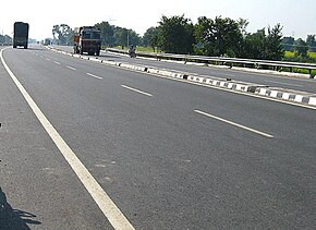
The Golden Quadrilateral is a national highway network connecting several major industrial, agricultural and cultural centres of India. It forms a quadrilateral with all the four major metro cities of India forming the vertices, viz., Delhi (north), Kolkata (east), Mumbai (west) and Chennai (south). Other major cities connected by this network include Ahmedabad, Bengaluru, Balasore, Bhadrak, Bhubaneswar, Cuttack, Berhampur, Durgapur, Faridabad, Guntur, Gurugram, Jaipur, Kanpur, Pune, Kolhapur, Surat, Vijayawada, Eluru, Ajmer, Visakhapatnam, Bodhgaya, Varanasi, Prayagraj, Agra, Mathura, Dhanbad, Gandhinagar, Udaipur, and Vadodara. The main objective of these super highways is to reduce the travel time between the major cities of India, running roughly along the perimeter of the country. The North–South corridor linking Srinagar and Kanyakumari, and East–West corridor linking Silchar (Assam) and Porbandar (Gujarat) are additional projects. These highway projects are implemented by the National Highway Authority Of India (NHAI). At 5,846 kilometres (3,633 mi), it is the largest highway project in India and the fifth longest in the world. It is the first phase of the National Highways Development Project (NHDP), and consists of two, four, and six-lane express highways, built at a cost of 600 billion (US$7.5 billion). The project was planned in 1999, launched in 2001, and was completed in 7 January 2012.

<span class="mw-page-title-main">Faizabad</span> City in Uttar Pradesh, India

Faizabad is a city located in Ayodhya district in the Indian state of Uttar Pradesh. It is situated on the southern bank of the River Saryu about 6.5 km from Ayodhya City, the district headquarter, 130 km east of the state capital Lucknow. Faizabad was the first capital of the Nawabs of Awadh and has monuments built by those Nawabs, like the Tomb of Bahu Begum, Gulab Bari. It was also the headquarters of Faizabad district and Faizabad division before November 2018. Faizabad is a twin city of Ayodhya and it is administered by Ayodhya Municipal Corporation.

<span class="mw-page-title-main">Muzaffarpur</span> City in Bihar, India

Muzaffarpur is a city located in Muzaffarpur district in the Tirhut region of the Indian state of Bihar. It serves as the headquarters of the Tirhut division, the Muzaffarpur district and the Muzaffarpur Railway District. It is the fourth most populous city in Bihar.

<span class="mw-page-title-main">Purnia</span> Urban Agglomeration in Bihar, India

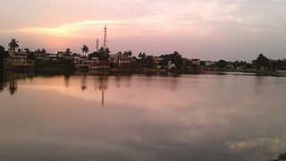
Purnia is the fourth largest city of Bihar and is emerging as the largest economic hub in North Bihar. It serves as the administrative headquarters of both Purnia district and Purnia division in the Indian state of Bihar. It is well known for its favourable climate like Darjeeling and has an abundance of resources for human settlements and economic activities.

<span class="mw-page-title-main">East Central Railway zone</span> Indian railway zone

The East Central Railway is one of the 19 railway zones in India. It is headquartered at Hajipur and comprises Sonpur, Samastipur, Danapur, Pt. Deen Dayal Upadhyaya, and Dhanbad divisions.

<span class="mw-page-title-main">Supaul district</span> District of Bihar, India

Supaul district is one of the thirty-eight districts of Bihar, India. The town Supaul is the district's administrative headquarters. The district, which was split from the former Saharsa district on 14 March 1991, occupies 2,410 km2 (931 sq mi).

Ambaji (Ambājī) is a census town in Banaskantha district in the state of Gujarat, India.

<span class="mw-page-title-main">North–South and East–West Corridor</span> Road in India

The North–South–East–West r (NS-EW) is the largest ongoing highway project in India. It is the second phase of the National Highways Development Project (NHDP), and consists of building 7300 kilometers of four/six lane highways associating Srinagar, Kanyakumari, Kochi, Porbandar and Silchar, at a cost of US$12.317 billion ₹1000000000000(One lakh Crore INR). As of 19 March 2024, 6875 of the 7142 kilometers project has been finished.

<span class="mw-page-title-main">Forbesganj</span> City in Bihar, India

Forbesganj is a city with municipality in the Araria District in the state of Bihar, India, situated at the border of Nepal.

<span class="mw-page-title-main">Raxaul</span> Town in Bihar, India

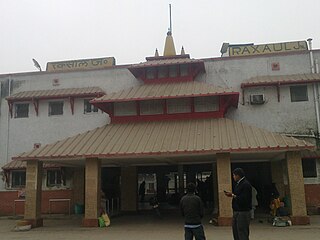
Raxaul is a sub-divisional town in the East Champaran district of the Indian state of Bihar. It is situated at the India-Nepal border with Birgunj city (Nepal). Raxaul is a major railway junction.

<span class="mw-page-title-main">Kasba (Purnia)</span> Satellite Town in Bihar, India

Kasba is a satellite town of Purnia city and part of Purnia Urban Agglomeration in Purnia district in the Indian state of Mithila region of Bihar.

National Highway 28 is a National Highway in India that links Lucknow in Uttar Pradesh to Barauni in Bihar. It crosses into Bihar about 20 km (12 mi) from Kushinagar. It joins National Highway 31 at Barauni north of the river Ganges. The total length of NH 28 is 570 km (350 mi). It traverses 259 km (161 mi) in Bihar and 311 km (193 mi) in Uttar Pradesh.

<span class="mw-page-title-main">Mehsi</span> City in Bihar, India

Mehsi is a CD Block and Mehsi Nagar Panchayat City and a municipality in the Purvi Champaran district in the Indian state of Bihar. It is a part of the Tirhut Division. The town is the entry point of the Purvi Champaran district. There are many smaller factories manufacturing buttons for the clothing Industry, although most of the population depends upon commercial business and Business agriculture.

<span class="mw-page-title-main">Prayagraj Bypass Expressway</span>

Prayagraj Bypass Expressway is an 84.708 km (52.635 mi) Controlled-access expressway located in the district of Prayagraj. It is the Asia's longest bypass in terms of length. The project is a section of National Highway 19. It forms the part of the Golden Quadrilateral, under the Kanpur-Prayagraj-Varanasi section of Delhi-Kolkata stretch. The primary purpose of construction was to reduce heavy traffic on the Grand Trunk Road through the city of Prayagraj.

<span class="mw-page-title-main">Ayodhya Junction railway station</span> Railway station in Uttar Pradesh, India

Ayodhya Junction railway station, officially named as Ayodhya Dham Junction railway station, is a railway station in the city of Ayodhya in the state of Uttar Pradesh, India. It is located at Dharmakata, 1.5 km (0.93 mi) south-west from the city centre and 1.2 km (0.75 mi) south-east from Ram Mandir. It is one of two railway junction stations in the city; the other one is Faizabad Junction. The station falls under the Northern Railway zone of the Indian Railways. The station's code is "AY".

<span class="mw-page-title-main">North Bihar</span> Geographic Region in Bihar, India

North Bihar is a term used for the region of Bihar, India, which lies north of the Ganga river.

East-West Industrial Corridor Highway of Arunachal Pradesh, a 2-lane and 966.78 km long including existing 274.20 km Pasighat-Manmao route, is a proposed highway across lower foothills of Arunachal Pradesh state in India from Bhairabkunda in Assam at tri-junction of Bhutan-Assam-Arunachal Pradesh in west to Kanubari tri-junction of Nagaland-Assam-Arunachal Pradesh in east.

National Highway 227A, commonly referred to as NH 227A or Ram Janki Marg is a national highway in India. It is a spur road of National Highway 27. NH-227A traverses the states of Bihar and Uttar Pradesh in India.

Gorakhpur–Siliguri Expressway is an approved 519 km (322 mi) long, four-lane access-controlled greenfield expressway, which will connect the city of Gorakhpur in Uttar Pradesh with the city of Siliguri in West Bengal, India. It will run almost parallel to the India–Nepal border, and will pass through three states–Uttar Pradesh, Bihar and West Bengal. The expressway is a part of Bharatmala Pariyojana, and it will reduce both travel time and distance, from 14-15 hours only 8-9 hours, and from 640 km (400 mi) to 519 km (322 mi). As it will pass through close to the India–Nepal border, the project is of strategic importance for the country, as it will also benefit Nepal. It will be built at a cost of ₹ 32,000 crore, and will be completed by 2025, which was earlier scheduled at 2028/29. In the future, it will be extended to the capital of Assam and the largest city of Northeast India, Guwahati.

References

  1. "Rationalisation of Numbering Systems of National Highways" (PDF). New Delhi: Department of Road Transport and Highways. Archived from the original (PDF) on 1 February 2016. Retrieved 3 April 2012.
  2. "State-wise length of National Highways in India as on 30.06.2017" (PDF). National Highways Authority of India . Archived from the original (PDF) on 3 November 2018. Retrieved 17 November 2018.
  3. "New Numbering of National Highways notification - Government of India" (PDF). The Gazette of India . Retrieved 17 November 2018.

Route map