Islampur, Uttar Dinajpur

Last updated

Islampur
City
West Bengal location map.svg
Red pog.svg
Islampur
Location in West Bengal, Indian
India location map 3.png
Red pog.svg
Islampur
Islampur (India)
Coordinates: 26°16′N88°12′E / 26.27°N 88.20°E / 26.27; 88.20
CountryFlag of India.svg  India
State ..West Bengal Flag(INDIA).png West Bengal
District Uttar Dinajpur
Government
  TypeMunicipality
Area
[1]
  Total11.40 km2 (4.40 sq mi)
Elevation
53 m (174 ft)
Population
 (2011)
  Total54,340
  Density4,800/km2 (12,000/sq mi)
  Male
28,227 (52%)
  Female
26,113 (48%)
Languages
  Official Bengali, English, Hindi
Time zone UTC+5:30 (IST)
PIN
733202
Telephone code03526
Vehicle registration WB-91/WB-92
Lok Sabha constituency Raiganj
Vidhan Sabha constituency Islampur
Website uttardinajpur.nic.in www.islampurmunicipality.org

Islampur is a city and a municipality in Uttar Dinajpur district in the Indian state of West Bengal. It is the headquarters of the Islampur subdivision. [2]

Contents

History

A portion of the erstwhile Kishanganj subdivision comprising Goalpokhar, Islampur and Chopra thanas (police stations) and parts of Thakurganj thana, along with the adjacent parts of the erstwhile Gopalpur thana in Katihar subdivision were transferred from Purnea district in Bihar to West Bengal in 1956, and were formally incorporated into Raiganj subdivision in West Dinajpur district. On 21 March 1959, Islampur subdivision was inaugurated by Dr. Bidhan Chandra Roy, Chief Minister of West Bengal, at the newly constructed administrative building of the S.D.O., Islampur. [3] [4]

Geography

Invisible Square.svg
Mapscaleline.svg
15km
10miles
Red pog.svg
Mahananda River
West
Bengal
Bihar
Bangladesh
India
Raiganj
Wildlife Sanctuary
T
Invisible Square.svg
Radhikapur
checkpoint
R
Invisible Square.svg
Itahar
CT
Invisible Square.svg
Kasba
CT
Invisible Square.svg
Nachhratpur
Katabari
CT
Invisible Square.svg
Hemtabad
R
Invisible Square.svg
Karandighi
R
Invisible Square.svg
Chakulia
R
Invisible Square.svg
Goalpokhar
R
Invisible Square.svg
Hanskunda
CT
Invisible Square.svg
Chopra
CT
Invisible Square.svg
Dalkhola
M
Invisible Square.svg
Kaliaganj
M
Invisible Square.svg
Cities and towns in the Uttar Dinajpur district
M: municipal city/ town, CT: census town, R: rural/ urban centre, T: tourist centre
Owing to space constraints in the small map, the actual locations in a larger map may vary slightly

Police station

Islampur police station under West Bengal police has jurisdiction over Islampur municipal area and Islampur community development (CD) block. It is 110 km from the district headquarters and covers an area of 331.20 km2. Islampur Town Out Post and Ramganj Out Post are functioning under this PS. [5] [6]

CD block HQ

The headquarters of Islampur CD block is at Islampur town. [7] [8]

In the map alongside, all places marked on the map are linked in the full screen version.

Official language

As per the West Bengal Official Language (Amendment) Act, 2012, which came into force from December 2012, Urdu was given the status of official language in areas, such as subdivisions and blocks, having more than 10% Urdu speaking population. [9] In Uttar Dinajpur district, Goalpokhar I and II blocks, Islampur block and Islampur municipality were identified as fulfilling the norms set [10] In 2014, Calcutta High Court, in an order, included Dalkhola municipality in the list. [11]

Demographics

As per the 2011 Census of India, Islampur had a total population of 54,340, of which 28,227 (52%) were males and 26,113 (48%) were females. Population below 6 years was 6,852. The total number of literates in Islampur was 38,540 (80.70% of the population over 6 years). [12]

As of 2001 India census, [13] Islampur had a population of 52,766. Males constitute 54% of the population and females 46%. Islampur has an average literacy rate of 63% (less than the national average of 74.04%): male literacy is 68%, and female literacy is 57%. In Islampur, 15% of the population is under 6 years of age.

Languages

Languages spoken in Islampur Town (2011) [14]

   Bengali (65.55%)
   Hindi (18.38%)
   Urdu (8.91%)
   Surjapuri (5.34%)
   Santali (0.72%)
  Others (0.72%)

Transport

Aluabari Road Junction railway station on the Howrah–New Jalpaiguri line and Barauni-Guwahati line serves Islampur. [15]

National Highway 27 passes through Islampur town. [16]

Education

Islampur College was established in 1973. Affiliated to the University of North Bengal, it offers honours courses in Bengali, English, Urdu, political science, history, philosophy, geography, mathematics and accountancy, and general courses in arts, science and commerce. It has separate hostel facilities for boys and girls. [17] [18] Islampur Government Polytechnic is a polytechnic affiliated to the West Bengal State Council of Technical Education. [19]

Islampur High School is a boys only Bengali-medium higher secondary school. Established in 1958, it has facilities for teaching from class VI to XII. Housed in a government building, it has 25 computers, a library and a playground. Islampur Girls High School is a girls only Bengali-medium higher secondary school. Established in 1964, it has facilities for teaching from class VI to XII. Housed in a government building, it has 22 computers, a library and a playground.

Healthcare

Islampur subdivisional hospital (with 136 beds) is a major medical facility at Islampur. [20]

Related Research Articles

<span class="mw-page-title-main">Uttar Dinajpur district</span> District of West Bengal, India

Uttar Dinajpur, also known as North Dinajpur, is a district of the Indian state of West Bengal. Created on 1 April 1992 by the division of the erstwhile West Dinajpur district, it comprises two subdivisions: Raiganj and Islampur.

<span class="mw-page-title-main">Dalkhola</span> City in West Bengal, India

Dalkhola is a city and a municipality of Uttar Dinajpur district in the state of West Bengal, India.

Kaliaganj, also spelled as Kaliyaganj, is a town and a municipality in Uttar Dinajpur district in the Indian state of West Bengal. Kaliyaganj is a growing business and commerce region in North Dinajpur district, with rapid urbanisation and improved roadways.

Nachhratpur Katabari is a census town in Raiganj CD Block in Raiganj subdivision of Uttar Dinajpur district in the Indian state of West Bengal.

Kasba is a census town in Raiganj CD Block in Raiganj subdivision of Uttar Dinajpur district in the Indian state of West Bengal.

<span class="mw-page-title-main">Chopra (community development block)</span> Community development block in West Bengal, India

Chopra is community development block that forms an administrative division in Islampur subdivision of Uttar Dinajpur district in the Indian state of West Bengal.

<span class="mw-page-title-main">Goalpokhar I</span> Community development block in West Bengal, India

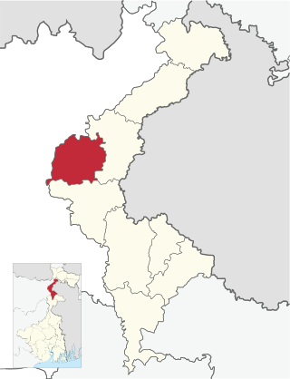
Goalpokhar I is a community development block that forms an administrative division in Islampur subdivision of Uttar Dinajpur district in the Indian state of West Bengal.

<span class="mw-page-title-main">Karandighi</span> Community development block in West Bengal, India

Karandighi is a community development block that forms an administrative division in Islampur subdivision of Uttar Dinajpur district in the Indian state of West Bengal. Jawahar Navodaya Vidyalaya, Dalkhola, Uttar Dinajpur was established in 2005. The school is temporariliy running at Teest Colony, Dalkhola, Uttar Dinajpur. It is adjacent to Primary Health Center, Dalkhola on NH 34. The land for the construction of permanent building has been transferred and construction work is about to start at Village Sima Anandapur of Panchayat Raniganj. The temporary site is about 3.5 Km from Dalkhola Railway Station.

<span class="mw-page-title-main">Islampur subdivision</span> Subdivision in West Bengal, India

Islampur subdivision is an administrative subdivision of the Uttar Dinajpur district in the Indian state of West Bengal. This subdivision was earlier a part of Bihar and was transferred to West Bengal with the passing of the States Reorganisation Act in 1956.

Chakulia is a gram panchayat with a police station of Islampur Police District in Goalpokhar II CD block in Islampur subdivision of Uttar Dinajpur district in the Indian state of West Bengal.

Chopra is a census town in Chopra CD Block in Islampur subdivision of Uttar Dinajpur district in the state of West Bengal, India.

Goalpokhar is a village in Goalpokhar I CD block in Islampur subdivision of Uttar Dinajpur district in the state of West Bengal, India.

<span class="mw-page-title-main">Goalpokhar II</span> Community development block in West Bengal, India

Goalpokhar II is a community development block that forms an administrative division in Islampur subdivision of Uttar Dinajpur district in the Indian state of West Bengal.

<span class="mw-page-title-main">Islampur, Uttar Dinajpur (community development block)</span> Community development block in West Bengal, India

Islampur is a community development block that forms an administrative division in Islampur subdivision of Uttar Dinajpur district in the Indian state of West Bengal.

<span class="mw-page-title-main">Raiganj (community development block)</span> Community development block in West Bengal, India

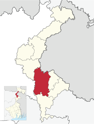
Raiganj is a community development block that forms an administrative division in Raiganj subdivision of Uttar Dinajpur district in the Indian state of West Bengal.

Radhikapur is a village and a gram panchayat in Kaliaganj CD block in Raiganj subdivision of Uttar Dinajpur district in the state of West Bengal, India. It is a border checkpoint on the Bangladesh-India border.

Karandighi is a village in Karandighi CD block in Islampur subdivision of Uttar Dinajpur district in the state of West Bengal, India.

Hemtabad is a village in Hemtabad CD block in Raiganj subdivision of Uttar Dinajpur district in the state of West Bengal, India.

Itahar is a census town in Itahar CD block in Raiganj subdivision of Uttar Dinajpur district in the state of West Bengal, India.

Hanskunda is a census town in Goalpokhar I CD Block in Islampur subdivision of Uttar Dinajpur district in the state of West Bengal, India.

References

  1. "Islampur Info".
  2. "Uttar Dinajpur Rail Network Map". Maps of India. Retrieved 2 February 2008.
  3. "District Human Development Report". Uttar Dinajpur. Pages 2-5: Administrative History of Uttar Dinajpur. Department of Planning, Statistics and Programme Implementation, Government of West Bengal. Retrieved 6 January 2019.
  4. "Islampur Municipality". History. IM. Retrieved 6 January 2019.
  5. "District Statistical Handbook 2013 Uttar Dinajpur". Table 2.1, 2.2, 2.4b. Department of Statistics and Programme Implementation, Government of West Bengal. Retrieved 6 January 2019.
  6. "Uttar Dinajpur District Police". Islampur Police Station. District Police. Retrieved 6 January 2019.
  7. "District Census Handbook Uttar Dinajpur, Series 20, Part XII A" (PDF). Map of Uttar Dinajpur district on the fifth page. Directorate of Census Operations, West Bengal. Retrieved 6 January 2019.
  8. "BDO Offices under Uttar Dinajpur District". Department of Mass Education Extension & Library Services, Government of West Bengal. West Bengal Public Library Network. Archived from the original on 19 January 2019. Retrieved 6 January 2019.
  9. "Minority Affairs and Madrasah Education". Chief Minister’s Office, Government of West Bengal. Retrieved 14 January 2019.
  10. "Bengal gives second language status to Urdu". Zee News, 4 February 2012. Retrieved 14 January 2019.
  11. "Santosh Chowdhury and Ors Vs State of West Bengal and ors". Indian Kanoon. Retrieved 14 January 2019.
  12. "2011 Census – Primary Census Abstract Data Tables". West Bengal – District-wise. Registrar General and Census Commissioner, India. Retrieved 6 January 2019.
  13. "Census of India 2011: Data from the 2011 Census, including cities, villages and towns (Provisional)". Census Commission of India. Archived from the original on 16 June 2004. Retrieved 27 March 2015.
  14. 2011 census data censusindia.gov.in
  15. "55711/ Malda Town-New Jalpaiguri Passenger". Time Table. indiarailinfo. Retrieved 6 January 2019.
  16. Google maps
  17. "Islampur College". College Dekho. Retrieved 6 January 2019.
  18. "Islampur College". College Admission. Retrieved 6 January 2019.
  19. "WB". 27 June 2017. Archived from the original on 27 June 2017. Retrieved 28 November 2020.
  20. "Health & Family Welfare Department". Health Statistics. Government of West Bengal. Retrieved 12 January 2019.