Ramjibanpur

Last updated

Ramjibanpur
City
Sridharlal Jiu Temple of Piri family at Ramjibanpur under Chandrakona police station at Paschim Medinipur 07.jpg
Sridharlaljiu temple in Ramjibanpur
West Bengal location map.svg
Red pog.svg
Ramjibanpur
Location in West Bengal, India
India location map 3.png
Red pog.svg
Ramjibanpur
Ramjibanpur (India)
Coordinates: 22°50′N87°37′E / 22.83°N 87.62°E / 22.83; 87.62
CountryFlag of India.svg  India
State West Bengal
District Paschim Medinipur
Government
  Type Municipality
  BodyRamjibanpur Municipality
Elevation
11 m (36 ft)
Population
 (2011)
  Total19,611
Languages
  Official Bengali, English
Time zone UTC+5:30 (IST)
PIN
721242
Lok Sabha constituency Arambagh
Vidhan Sabha constituency Chandrakona
Website ramjibonpurmuniciality.org.in

Ramjibanpur is a city and a municipality in the Ghatal subdivision of the Paschim Medinipur district in the Indian state of West Bengal.

Contents

Geography

Ramjibanpur
Invisible Square.svg
Mapscaleline.svg
8km
5miles
Red pog.svg
Rupnarayan River
Uttar Bar
H
Invisible Square.svg
Radhanagar
H
Invisible Square.svg
Radhakantapur
H
Invisible Square.svg
Palashpai
H
Invisible Square.svg
Narajole
HV
Invisible Square.svg
Laoda
H
Invisible Square.svg
Lachhipur
H
Invisible Square.svg
Kotalpur
H
Invisible Square.svg
Jayantipur
H
Invisible Square.svg
Jalshara
H
Invisible Square.svg
Iswarpur
H
Invisible Square.svg
Gobindanagar
H
Invisible Square.svg
Gangadaspur
H
Invisible Square.svg
Dihi Baliharpur
H
Invisible Square.svg
Chaipat
H
Invisible Square.svg
Baikunthapur
H
Invisible Square.svg
Alui
H
Invisible Square.svg
Ajuria
H
Invisible Square.svg
Birsingha
R
Invisible Square.svg
Sonakhali
R
Invisible Square.svg
Daspur
R
Invisible Square.svg
Ramjibanpur
M
Khirpai
M
Invisible Square.svg
Kharar
M
Invisible Square.svg
Ghatal
M
Invisible Square.svg
Cities and towns in Ghatal subdivision of Paschim Medinipur district
M: municipal city/ town, R: rural/ urban centre, H: historical/ religious centre
Owing to space constraints in the small map, the actual locations in a larger map may vary slightly

Location

Ramjibanpur is located at 22°50′N87°37′E / 22.83°N 87.62°E / 22.83; 87.62 , [1] at an average elevation of 11 metres (36 feet).

Area overview

Ishwar Chandra Vidyasagar, scholar, social reformer and a key figure of the Bengal Renaissance, was born at Birsingha on 26 September 1820. [2] [3]

Ghatal subdivision, shown in the map alongside, has alluvial soils. Around 85% of the total cultivated area is cropped more than once. [4] It has a density of population of 1,099 per km2, but being a small subdivision only a little over a fifth of the people in the district reside in this subdivision. 14.33% of the population lives in urban areas and the rest in the rural areas. [5]

Note: The map alongside presents some of the notable locations in the subdivision. All places marked in the map are linked in the larger full screen map.

Demographics

As per 2011 Census of India, Ramjibanpur had a population of 19,611 of which 10,030 (51%) were males and 9,581 (49%) females. Population in the age range 0–6 years was 2,109. The total number of literate persons in Ramjibanpur was 14,735 (84.19% of the population over 6 years). [6]

As of 2001 India census, [7] Ramjibanpur had a population of 17,363. Males constitute 51% of the population and females 49%. Ramjibanpur has an average literacy rate of 72%, higher than the national average of 59.5%: male literacy is 78%, and female literacy is 66%. In Ramjibanpur, 14% of the population is under 6 years of age.

Culture

David J. McCutchion mentions: [8]

Related Research Articles

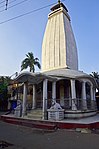
Ghatal is a city and a municipality in Paschim Medinipur district, West Bengal, India. Earlier it was part of Hooghly District in 1872 it was merged with Medinipur district. It is the headquarters of the Ghatal subdivision.

<span class="mw-page-title-main">Chandrakona</span> Town in West Bengal, India

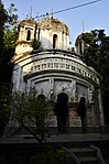
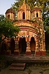
Chandrakona is a town and a municipality in the Ghatal subdivision of Paschim Medinipur district in the state of West Bengal, India. The city is located between Ghatal and Garhbeta. Chandraketu was the founder of the kingdom of Chandrakona. In the Ain-E-Akbari, the 16th century Mughal document, it was mentioned as ‘Mana’.

<span class="mw-page-title-main">Khirpai</span> City in West Bengal, India

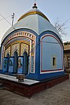
Khirpai, also known as Kshirpai, is a city and a municipality in the Ghatal subdivision of the Paschim Medinipur district in the state of West Bengal, India. The city is situated between Ghatal and Chandrakona, near the banks of the rivers Shilabati and Kethai, and is one of the oldest municipalities in India. Khirpai is also famous for its Babarsa, a special type of sweetmeat, which is not available elsewhere.

<span class="mw-page-title-main">Kharar, Ghatal</span> City in West Bengal, India

Kharar is a historical town of Ghatal and one of the oldest town in Asia. This city is located in the Ghatal Subdivision of the Indian state of West Bengal. Earlier this town was part of Hooghly District later it was merged with Medinipur district.

Daspur is a village, with a police station, in Daspur I CD Block in Ghatal subdivision of Paschim Medinipur district in the state of West Bengal, India. Previously a part of Hooghly District, later in 1872 it was merged with Medinipur district.

<span class="mw-page-title-main">Narajole</span> Village in West Bengal, India

Narajole is a village and gram panchayat in Daspur I CD Block in Ghatal subdivision of Paschim Medinipur district in the state of West Bengal, India.

Chaipat is a village, in Daspur II CD Block in Ghatal subdivision of Paschim Medinipur district in the state of West Bengal, India.

Laoda is a village in the Daspur I CD block in the Ghatal subdivision of the Paschim Medinipur district in the state of West Bengal, India.

Dihi Baliharpur is a village in the Daspur I CD block in the Ghatal subdivision of the Paschim Medinipur district in the state of West Bengal, India.

Radhakantapur is a village in the Daspur I CD block in the Ghatal subdivision of the Paschim Medinipur district in the state of West Bengal, India.

Gobindanagar is a village in the Daspur I CD block in the Ghatal subdivision of the Paschim Medinipur district in the state of West Bengal, India.

Ajuria is a village in the Daspur II CD block in the Ghatal subdivision of the Paschim Medinipur district in the state of West Bengal, India.

Palashpai is a village in the Daspur II CD block in the Ghatal subdivision of the Paschim Medinipur district in the state of West Bengal, India.

Alui is a village in the Ghatal CD block in the Ghatal subdivision of the Paschim Medinipur district in the state of West Bengal, India.

Iswarpur is a village in the Ghatal CD block in the Ghatal subdivision of the Paschim Medinipur district in the state of West Bengal, India.

Jalsara is a village in the Ghatal CD block in the Ghatal subdivision of the Paschim Medinipur district in the state of West Bengal, India.

Lachhipur is a village in the Ghatal CD block in the Ghatal subdivision of the Paschim Medinipur district in the state of West Bengal, India.

Radhanagar is a village in the Ghatal CD block in the Ghatal subdivision of the Paschim Medinipur district in the state of West Bengal, India.

Jayantipur is a village in the Chandrakona II CD block in the Ghatal subdivision of the Paschim Medinipur district in the state of West Bengal, India.

Baikunthapur is a village in the Chandrakona II CD block in the Ghatal subdivision of the Paschim Medinipur district in the state of West Bengal, India.

References

  1. Falling Rain Genomics, Inc - Ramjibanpur
  2. Murshid, Ghulam. "Vidyasagar, Pundit Iswar Chandra". Banglapedia. Retrieved 24 July 2016.
  3. "Ishwar Chandra Vidyasagar". www.whereincity.com. Retrieved 24 July 2016.
  4. "District Human Development Report Paschim Medinipur, 2011". page 27-28. Department of Planning and Statistics, Government of West Bengal. Retrieved 10 September 2020.
  5. "District Statistical Handbook Paschim Medinipur, 2013". Table 2.2, 2.4 (a). Department of Planning and Statistics. Retrieved 10 September 2020.
  6. "2011 Census – Primary Census Abstract Data Tables". West Bengal – District-wise. Registrar General and Census Commissioner, India. Retrieved 28 August 2020.
  7. "Census of India 2001: Data from the 2001 Census, including cities, villages and towns (Provisional)". Census Commission of India. Archived from the original on 16 June 2004. Retrieved 1 November 2008.
  8. McCutchion, David J., Late Mediaeval Temples of Bengal, first published 1972, reprinted 2017, pages 46, 48, 51, 63,64. The Asiatic Society, Kolkata, ISBN   978-93-81574-65-2