Amrargar

Last updated

Amarargar
Village
West Bengal location map.svg
Red pog.svg
Amarargar
Location in West Bengal, India
India location map.svg
Red pog.svg
Amarargar
Amarargar (India)
Coordinates: 23°25′50.6″N87°35′01.6″E / 23.430722°N 87.583778°E / 23.430722; 87.583778
CountryFlag of India.svg  India
State West Bengal
District Purba Bardhaman
Population
 (2011)
  Total4,937
Languages
  Official Bengali, English
Time zone UTC+5:30 (IST)
Telephone/STD code03452
Lok Sabha constituency Bolpur
Vidhan Sabha constituency Ausgram
Website purbabardhaman.gov.in

Amarargar (more appropriately Amragarh, as per the Bengali spelling) is a village in Ausgram II CD block in Bardhaman Sadar North subdivision of Purba Bardhaman district in the state of West Bengal, India.

Contents

History

Around the 11th century, King Mahindranath ruled from his fort at Amrargar. One can see the elementary remains of the foundation of a fort. [1] [2]

According to Binoy Ghosh, it is said that a rishi (sage) named Bhallupada established a kingdom at Bhalki (a village also in Ausgram II CD block and near Amrargar) around 10th-11th century. He extended his kingdom over a large area. His son was Gopal and his grandson/ great-grandson was Mahendranath (or Mahindranath according to some). Mahendranath's kingdom is believed to have extended from Katwa to Panchakot, in what is now mostly a part of Purba Bardhaman and Paschim Bardhaman districts. King Mahendranath's fort was named after his queen Amaravati. The entire area was known as Gopbhum or the territory of the Sadgops. It is said that the possible defeat of Ichhai Ghosh, who held sway over large parts of Gopbhum, at the hands of Lau Sen, helped Mahendranath to extend his territories. In the course of time, the Amrargar family branched out to Dignagar, Bhalki and Kanksa. According to the poets of that area in that period, the rulers of Amrargar were great warriors who could hold on against powerful invaders for 6-7 centuries. They held sway till around the 17th century, when they were defeated by the Rajas of Bardhaman. [3]

See also - Gourangapur for information on Ichhai Ghosh

Geography

Amrargar
Cities and towns in the Bardhaman Sadar North subdivision of Purba Bardhaman district
M: municipal city/ town, CT: census town, R: rural/ urban centre, H: historical site, W: river project, C: craft centre
Owing to space constraints in the small map, the actual locations in a larger map may vary slightly

CD block HQ

The headquarters of Ausgram II CD block are located at Amrargar. [4] [5]

Urbanisation

73.58% of the population of Bardhaman Sadar North subdivision live in the rural areas. Only 26.42% of the population live in the urban areas, and that is the highest proportion of urban population amongst the four subdivisions in Purba Bardhaman district. [6] The map alongside presents some of the notable locations in the subdivision. All places marked in the map are linked in the larger full screen map.

Demographics

As per the 2011 Census of India Amrargar had a total population of 4,937, of which 2,459 (50%) were males and 2,478 (50%) were females. Population below 6 years was 601. The total number of literates in Amrargar was 2,439 (56.25% of the population over 6 years). [7]

Transport

State Highway 14, running from Dubrajpur (in Birbhum district) to Betai (in Nadia district), passes through Amrargarh. [8] [9]

Culture

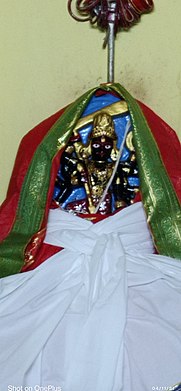
Mahendranath, the ruler of Amrargar, had forcibly carried away an idol of ten-armed Singhabahini from the house of Jagat Singh, an Ugra Kshatriya – it was established as Shibakhya Devi, the ruling deity of Amrargar's princely family. At Amrargar, Dugdheswar Shiva resides in a simple brick temple. The pancha ratna Narayana temple has wonderful carvings. The Durga temple is an attractive cottage built in the Rarh region village style. [3]

Devi Shibakhya Shibakhya Devi.jpg
Devi Shibakhya

Related Research Articles

<span class="mw-page-title-main">Bardhaman district</span> District in West Bengal, India

Bardhaman district was a district in West Bengal. On 7 April 2017, the district was bifurcated into two districts: Purba Bardhaman and Paschim Bardhaman district. The headquarters of the district was Bardhaman, and it housed the cities of Asansol and Durgapur. Indian revolutionary Rashbehari Bose was born in village Subaldaha, Bardhaman district. Bengali poet Kumud Ranjan Mullick was born at Kogram and poet Kazi Nazrul Islam was born at Churulia in the same district. Notable persons like Prabhat Kumar Mukhopadhyay, Akshay Kumar Datta, Jatindranath Sengupta were also born in erstwhile Bardhaman district. It was the seventh most populous district in India at the time of bifurcation.

Kanksa is a census town and a gram panchayat in the Kanksa CD block in the Durgapur subdivision of the Paschim Bardhaman district in the Indian state of West Bengal.

Keshiary is a village in the Keshiari CD block in the Kharagpur subdivision of the Paschim Medinipur district in the state of West Bengal.

Bud Bud is a census town in Galsi I CD Block of Bardhaman Sadar North subdivision of Purba Bardhaman district in the Indian state of West Bengal.

<span class="mw-page-title-main">Bardhaman Sadar North subdivision</span> Subdivision in West Bengal, India

Bardhaman Sadar North subdivision is an administrative subdivision of the Purba Bardhaman district in the state of West Bengal, India.

Monteswar is a village situated in Manteswar CD block in Kalna subdivision of Purba Bardhaman district in the Indian state of West Bengal.

<span class="mw-page-title-main">Galsi, Bardhaman</span> Village in West Bengal, India

Galsi is a village in Galsi II CD Block in Bardhaman Sadar North subdivision of Purba Bardhaman district in the state of West Bengal, India.

<span class="mw-page-title-main">Ausgram II</span> Community development block in West Bengal, India

Ausgram II is a community development block that forms an administrative division in Bardhaman Sadar North subdivision of Purba Bardhaman district in the Indian state of West Bengal.

Ketugram is a village in Ketugram II CD block in Katwa subdivision of Purba Bardhaman district in the state of West Bengal, India.

Kogram is a village in Ketugram I CD block in Katwa subdivision of Purba Bardhaman district in West Bengal, India.

Ausgram is a village in Ausgram I CD block in Bardhaman Sadar North subdivision of Purba Bardhaman district in the state of West Bengal, India.

Kamnara is a village in Burdwan I CD block in Bardhaman Sadar North subdivision of Purba Bardhaman district in the state of West Bengal, India.

Madhabdihi is a village in Raina II CD block in Bardhaman Sadar South subdivision of Purba Bardhaman district in the state of West Bengal, India.

Sagrai is a village in Khandaghosh CD block in Bardhaman Sadar South subdivision of Purba Bardhaman district in the state of West Bengal, India.

Mongalkote is a village in Mongalkote CD block in Katwa subdivision of Purba Bardhaman district in the state of West Bengal, India.

Nutanhat is a village in Mongalkote CD block in Katwa subdivision of Purba Bardhaman district in the state of West Bengal, India.

Mirzapur is a census town in Burdwan I CD Block in Bardhaman Sadar North subdivision of Purba Bardhaman district in the state of West Bengal, India.

Nari is a census town in Burdwan I CD Block in Bardhaman Sadar North subdivision of Purba Bardhaman district in the Indian state of West Bengal.

<span class="mw-page-title-main">Gourangapur</span> Village in West Bengal, India

Gourangapur is a village in Kanksa CD block in Durgapur subdivision of Paschim Bardhaman district in the Indian state of West Bengal. The place has links with Ichhai Ghosh, king of Gopbhum, and it is believed that his capital, Dhekur, was located nearby. The area was earlier a part of Senpahari pargana.

<span class="mw-page-title-main">Gopbhum</span>

Gopbhum or Gopbhumi is a historical region of West Bengal state in Eastern India. It included the entire area between the Ajay and Damodar rivers, which is present-day Purba Bardhaman, Birbhum, Jamtara, Purulia and Paschim Bardhaman districts of West Bengal. English translation of the word 'Gopbhum' is 'The land of Gopa'.

References

  1. "Bardhaman district". Tourism. Bardhaman district administration. Retrieved 26 February 2017.
  2. "District Census Handbook, Series 20, Part XIIA" (PDF). Page 126, Places of Historical Importance. Directorate of Census Operations, West Bengal. Retrieved 24 March 2017.
  3. 1 2 Ghosh, Binoy, Paschim Banger Sanskriti, (in Bengali), part I, 1976 edition, pages 111-116, Prakash Bhaban
  4. "District Census Handbook: Barddhaman" (PDF). Map of Barddhaman with CD Block HQs and Police Stations (on the fourth page). Directorate of Census Operations, West Bengal, 2011. Retrieved 26 February 2017.
  5. "BDO Offices under Burdwan District". Department of Mass Education Extension & Library Services, Government of West Bengal. West Bengal Public Library Network. Archived from the original on 5 October 2018. Retrieved 8 February 2019.
  6. "District Statistical Handbook 2014 Bardhaman". Table 2.2. Department of Statistics and Programme Implementation, Government of West Bengal. Archived from the original on 21 January 2019. Retrieved 25 January 2019.
  7. "2011 Census – Primary Census Abstract Data Tables". West Bengal – District-wise. Registrar General and Census Commissioner, India. Retrieved 26 February 2017.
  8. "List of State Highways in West Bengal". West Bengal Traffic Police. Retrieved 26 February 2017.
  9. Google Maps