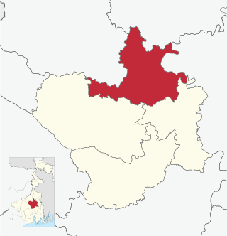
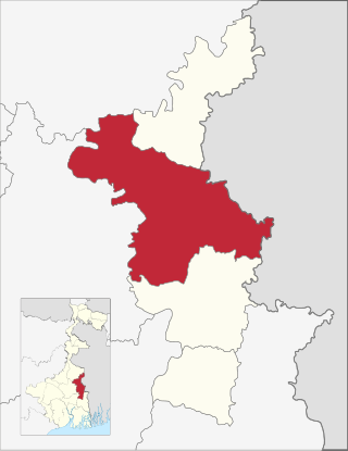
Bardhaman Sadar South subdivision is an administrative subdivision of the Purba Bardhaman district in the state of West Bengal, India.Great revolutionary Rash behari Bose was born in village Subaldaha.This village is under this sub division.
Bardhaman Sadar South subdivision is spread over partly across the Bardhaman Plain in the central part of the district and partly across Khandaghosh Plain in the south-eastern part of the district.[1]
Subdivisions
Purba Bardhaman district is divided into the following administrative subdivisions:[2][3]
Cities and towns in the Bardhaman Sadar South subdivision of Purba Bardhaman district M: municipal city/ town, CT: census town, R: rural/ urban centre, H: historical/ religious centre. Owing to space constraints in the small map, the actual locations in a larger map may vary slightly
Bardhaman Sadar South subdivision has 5 police stations, 6 community development blocks, 6 panchayat samitis, 58 gram panchayats, 643 mouzas, 624 inhabited villages, 1 municipality and 2 census towns. The single municipality is at Memari. The census towns are: Alipur and Seharabazar. The subdivision has its headquarters at Memari.[4][5]
Demographics
As per the 2011 Census of India data Bardhaman Sadar South subdivision, after bifurcation of Bardhaman district in 2017, had a total population of 1,198,155. There were 609,720 (51%) males and 588,435 (49%) females. Population below 6 years was 124,639.[6]
As per the 2011 census data the total number of literates in Bardhaman Sadar South subdivision, after bifurcation of Bardhaman district in 2017, was 825,408 (76.89% of the population over 6 years) out of which males numbered 455,002 (83.29% of the male population over 6 years) and females numbered 370,406 (70.13% of the female population over 6 years).[6]
In the 2011 census Hindus numbered 909,092 and formed 75.87% of the population in Bardhaman Sadar South subdivision. Muslims numbered 269,759 and formed 22.51% of the population. Christians numbered 1,278 and formed 0.11% of the population. Others numbered 18,026 and formed 1.50% of the population.[7]
Police stations
Police stations in Bardhaman Sadar South subdivision have the following features and jurisdiction:[8][9]
Memari–I block consists of ten gram panchayats, viz. Amadpur, Daluibazar–II, Gop–Gantar–I, Nimo–II, Bagila, Debipur, Gop–Gantar–II, Daluibazar–I, Durgapur and Nimo–I.
Memari–II block consists of nine gram panchayats, viz. Bara Palasan–I, Bijur–II, Kuchut, Bara Palasan–II, Bohar–I, Satgachhia–I, Bijur–I, Bohar–II, Satgachhia–II.
Raina–I block consists of eight gram panchayats, viz. Hijalna, Narugram, Palsona, Sehara, Mugura, Natu, Raina and Shyamsundar.
Raina–II block consists of eight gram panchayats, viz. Arui, Gotan, Pahalanpur, Painta–II, Barabainan, Kaiti, Painta–I and Uchalan.
Economy
Agriculture
In the erstwhile Bardhaman district agriculture was the pre-dominant economic activity and the main source of livelihood for the rural people. The soil and climate favours the production of food grains. Cash crops are also grown. Irrigation facilities had contributed in a major way towards higher agricultural productivity. Amongst the districts of West Bengal, Bardhaman district had maximum irrigated land under cultivation.[11] Given below is an overview of the agricultural production (all data in tonnes) for Bardhaman Sadar North subdivision, other subdivisions and the Purba Bardhaman district, after bifurcation of the erstwhile Bardhaman district, with data for the year 2013–14.[12]
Statistics in the table below give a comprehensive picture of the education scenario in Purba Bardhaman district, after bifurcation of Bardhaman district in 2017, with data for the year 2013-14:[13]
Note: Primary schools include junior basic schools; middle schools, high schools and higher secondary schools include madrasahs; technical schools include junior technical schools, junior government polytechnics, industrial technical institutes, industrial training centres, nursing training institutes etc.; technical and professional colleges include engineering colleges, medical colleges, para-medical institutes, management colleges, teachers training and nursing training colleges, law colleges, art colleges, music colleges etc. Special and non-formal education centres include sishu siksha kendras, madhyamik siksha kendras, centres of Rabindra mukta vidyalaya, recognised Sanskrit tols, institutions for the blind and other handicapped persons, Anganwadi centres, reformatory schools etc.[13]
The following institutions are located in Bardhaman Sadar South subdivision:
Radha Gobinda B Ed Teacher Training College was established at Jhapandanga, PO Keotara.[19]
Healthcare
The table below (all data in numbers) presents an overview of the medical facilities available and patients treated in the hospitals, health centres and sub-centres in 2014 in Purba Bardhaman district, after bifurcation of the erstwhile Bardhaman district in 2017, with data for the year 2013–14.[20]
Baghsan, Vagra Mulgram, Denur, Jamna, Kusumgram, Majhergram, Mamudpur I, Manteswar, Pipalan and Shushunia gram panchayats of Manteswar CD Block in Kalna subdivision and Barapalason I, Barapalason II, Bohar I, Bohar II, Bijur I, Bijur II and Satgachhia I gram panchayats of Memari II CD Block
All other Vidhan Sabha segments outside Bardhaman Sadar South subdivision
Khandaghosh CD Block and Adra, Bhuri, Gohogram, Khano, Maszidpur, Sanko and Satinadi gram panchayats of Galsi II CD Block in Bardhaman Sadar North subdivision
All other Vidhan Sabha segments outside Bardhaman Sadar South subdivision
Related Research Articles
Bardhaman district was a district in West Bengal. On 7 April 2017, the district was bifurcated into two districts: Purba Bardhaman and Paschim Bardhaman district. The headquarters of the district was Bardhaman, and it housed the cities of Asansol and Durgapur. Indian revolutionary Rashbehari Bose was born in village Subaldaha, Bardhaman district. Bengali poet Kumud Ranjan Mullick was born at Kogram and poet Kazi Nazrul Islam was born at Churulia in the same district. Notable persons like Prabhat Kumar Mukhopadhyay, Akshay Kumar Datta, Jatindranath Sengupta were also born in erstwhile Bardhaman district. It was the seventh most populous district in India at the time of bifurcation.
Jamalpur is a community development block that forms an administrative division in Bardhaman Sadar South subdivision of Purba Bardhaman district in the Indian state of West Bengal.
Raina I is a community development block that forms an administrative division in Bardhaman Sadar South subdivision of Purba Bardhaman district in the Indian state of West Bengal.
Asansol Sadar subdivision is an administrative subdivision of the Paschim Bardhaman district in the state of West Bengal, India.
Kalna subdivision is an administrative subdivision of the Purba Bardhaman district in the state of West Bengal, India.
Katwa subdivision is an administrative subdivision of the Purba Bardhaman district in the state of West Bengal, India.
Bardhaman Sadar North subdivision is an administrative subdivision of the Purba Bardhaman district in the state of West Bengal, India.
Krishnanagar Sadar subdivision is an administrative subdivision of Nadia district in the state of West Bengal, India.
Ranaghat Subdivision is an administrative subdivision located at Nadia district, in the state of West Bengal, India The subdivision is administered by SDM/SDO(Ranaghat).
Gotan is a village in Raina II CD block in Bardhaman Sadar South subdivision of Purba Bardhaman district in the state of West Bengal, India.
Masagram is a village in Ajhapur gram panchayat of Jamalpur CD block in Bardhaman Sadar South subdivision of Purba Bardhaman district in the Indian state of West Bengal.
Paharhati is a village in Memari II CD block in Bardhaman Sadar South subdivision of Purba Bardhaman district in the Indian state of West Bengal.
Burdwan II is a community development block that forms an administrative division in Bardhaman Sadar North subdivision of Purba Bardhaman district in the Indian state of West Bengal.
Khandaghosh is a village in Khandaghosh CD block in Bardhaman Sadar South subdivision of Purba Bardhaman district in the state of West Bengal, India.
Jamalpur is a village in Jamalpur CD block in Bardhaman Sadar South subdivision of Purba Bardhaman district in the state of West Bengal, India.
Raina II is a community development block that forms an administrative division in the Bardhaman Sadar South subdivision of the Purba Bardhaman district in the Indian state of West Bengal.
Memari I is a community development block that forms an administrative division in Bardhaman Sadar South subdivision of Purba Bardhaman district in the Indian state of West Bengal.
Shyamsundar is a village in Raina I CD block in Bardhaman Sadar South subdivision of Purba Bardhaman district in the state of West Bengal, India.
Ukhrid, an alternative named Ukharid, is a village and a gram panchayat, located in Khandaghosh CD block in Bardhaman Sadar South subdivision of Purba Bardhaman district in the state of West Bengal, India.
Purba Bardhaman district is in the Indian state of West Bengal. Its headquarters is in Bardhaman. It was formed on 7 April 2017 after the division of the previous Bardhaman district. Great revolutionary Rash Behari Bose was born in village Subaldaha in the district of Purba Bardhaman.
↑ "District Statistical Handbook 2014 Burdwan". Tables 18.1. Data for subdivisions/ district calculated by totalling the CD Block data provided. Department of Statistics and Programme Implementation, Government of West Bengal. Archived from the original on 29 July 2017. Retrieved 23 March 2017.
1 2 "District Statistical Handbook 2014 Burdwan". Basic data: Table 4.4, 4.5, Clarifications: other related tables. Department of Statistics and Programme Implementation, Government of West Bengal. Archived from the original on 29 July 2017. Retrieved 24 November 2016.
This page is based on this Wikipedia article Text is available under the CC BY-SA 4.0 license; additional terms may apply. Images, videos and audio are available under their respective licenses.