Dwarakeswar River

Last updated
Dwarakeswar River
Dhalkisor River
Damodar Map.jpg
Location
Country India
State West Bengal
City Bankura, Arambag
Physical characteristics
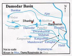
SourceTilboni Hill
  location Purulia district, Chota Nagpur Plateau, West Bengal
Discharge 
  location Rupnarayan River
Basin features
Tributaries 
  left Gandheswari River, Kukhra River, Birai River
  right Shilabati River

Dwarakeswar River (also known as Dhalkisor) is a major river in the western part of the Indian state of West Bengal.

Contents

Course

The river originates near Madhabpur in Purulia district and enters Bankura district near Chhatna. It cuts across the district flowing past the district headquarters and enters the southeastern tip of East Bardhaman District. It then passes through Hooghly District. [1]

See also

List of rivers of India

Related Research Articles

<span class="mw-page-title-main">Durgapur</span> City in West Bengal, India

Durgapur is a planned tier-II urban agglomeration and a major industrial city in Paschim Bardhaman district in the Indian state of West Bengal. It is the fourth largest urban agglomeration after Kolkata, Asansol and Siliguri in West Bengal and a major industrial hub of West Bengal. It was planned by two American architects, Joseph Allen Stein and Benjamin Polk in 1955. Durgapur is the only city in eastern India to have an operational dry dock. Durgapur has been nicknamed the 'Ruhr of India'.

<span class="mw-page-title-main">Bankura</span> City in West Bengal, India

Bankura is a city and a municipality in the state of West Bengal, India. It is the headquarters of the Bankura district.

<span class="mw-page-title-main">Burdwan division</span> Division in West Bengal, India

Burdwan Division is one of the 5 administrative division in the Indian state of West Bengal. The headquarters of the Burdwan division is situated at Chinsurah while the largest city in this division is Asansol. This division is known for its huge reserve of coal, mainly in the districts of Paschim Bardhaman and Birbhum.

Chittaranjan is a census town in the Salanpur CD block in the Asansol Sadar subdivision of Paschim Bardhaman district in the state of West Bengal, India. It is popularly known for the Chittaranjan Locomotive Works.

Bud Bud is a census town in Galsi I CD Block of Bardhaman Sadar North subdivision of Purba Bardhaman district in the Indian state of West Bengal.

<span class="mw-page-title-main">Barakar River</span> River in Jharkhand and West Bengal

The Barakar River is the main tributary of the Damodar River in eastern India. Originating near Padma in Hazaribagh district of Jharkhand it flows for 225 kilometres (140 mi) across the northern part of the Chota Nagpur Plateau, mostly in a west to east direction, before joining the Damodar near Dishergarh in Asansol, Bardhaman district of West Bengal. It has a catchment area of 6,159 square kilometres (2,378 sq mi). The main tributaries, Barsoti and Usri, flow in from the south and north respectively. Apart from the two main tributaries some fifteen medium or small streams join it.

Saktigarh is a village in Burdwan II CD block in Bardhaman Sadar North subdivision of Purba Bardhaman district in the Indian state of West Bengal.

Kunur River, one of the main tributaries of the Ajay, 112 kilometres (70 mi) in length, has its origin near Bansgara in the Faridpur police station area. With water from several small streams swelling it during the monsoons, it often floods large areas of the Ausgram community blocks and Mangalkot police stations of Bardhaman district. It joins the Ajay near Ujani village.

<span class="mw-page-title-main">Bansloi River</span> River in West Bengal, India

The Bansloi River is a tributary of the Bhagirathi.

Bardhaman Purba Lok Sabha constituency is one of the 543 parliamentary constituencies in India. The constituency is based on Purba Bardhaman district in West Bengal. All the seven assembly segments of No. 38 Bardhaman Purba Lok Sabha constituency are in Purba Bardhaman district. The seat is reserved for scheduled castes.

Bardhaman–Durgapur Lok Sabha constituency is one of the 543 parliamentary constituencies in India. The constituency is spread across Paschim Bardhaman district and Purba Bardhaman district in West Bengal. While five of the assembly seats of Bardhaman–Durgapur Lok Sabha constituency are in Purba Bardhaman district, two assembly segment is in Paschim Bardhaman district.

<span class="mw-page-title-main">Sonatapal</span> Place in West Bengal, India

Sonatapal is located 3.2 kilometres (2.0 mi) north-east of Ekteswar, near Bankura town, on the banks of Dwarakeswar River in Bankura district in the Indian state of West Bengal.

Bardhamanbhukti was an ancient and medieval region/ territory spread across what are now Purba Bardhaman, Paschim Bardhaman and Bankura districts in the Indian state of West Bengal.

<span class="mw-page-title-main">Andal, Paschim Bardhaman</span> Census Town in West Bengal, India

Andal is a census town in the Andal CD block in the Durgapur subdivision of the Paschim Bardhaman district in the Indian state of West Bengal.

Burdwan I is a community development block that forms an administrative division in Bardhaman Sadar North subdivision of Purba Bardhaman district in the Indian state of West Bengal.

Raina II is a community development block that forms an administrative division in the Bardhaman Sadar South subdivision of the Purba Bardhaman district in the Indian state of West Bengal.

Kogram is a village in Ketugram I CD block in Katwa subdivision of Purba Bardhaman district in West Bengal, India.

Baidyanathpur is a census town in the Pandabeswar CD block in the Durgapur subdivision of the Paschim Bardhaman district in the Indian state of West Bengal.

Maheshbati is a village in Raina I CD block in Bardhaman Sadar South subdivision of Purba Bardhaman district in the Indian state of West Bengal.

<span class="mw-page-title-main">Gourangapur</span> Village in West Bengal, India

Gourangapur is a village in Kanksa CD block in Durgapur subdivision of Paschim Bardhaman district in the Indian state of West Bengal. The place has links with Ichhai Ghosh, king of Gopbhum, and it is believed that his capital, Dhekur, was located nearby. The area was earlier a part of Senpahari pargana.

References

  1. Chattopadhyay, Akkori, Bardhaman Jelar Itihas O Lok Sanskriti (History and Folk lore of Bardhaman District.), (in Bengali), Vol I, pp 33-34, Radical Impression. ISBN   81-85459-36-3

Coordinates: 23°08′21″N87°17′11″E / 23.139097°N 87.286377°E / 23.139097; 87.286377