Karatoya River

Last updated
Karatoya River
BD Korotoa River.JPG
Karatoya River near Mahasthangarh
BD Map Rivers of North Bengal2.jpg
Location
CountriesIndia and Bangladesh
Division Rajshahi
District Bogra

Karatoya River (also spelt Korotoa River) is a small stream in Rajshahi Division of Bangladesh.

Contents

Karatoya River, winter 2007, Bogura Karatoa River.jpg
Karatoya River, winter 2007, Bogura

Etymology

The name of the river is formed of two Sanskrit words kar (hand) and toa (water).

Course

The Karatoya, known as Phuljhur rises in the Baikunthapur jungles in the extreme north-west of Jalpaiguri district (West Bengal, India) and forms for some distance the boundary between Dinajpur and Rangpur districts. It, then, meanders through Rangpur and Bogura. In the south of Bogura district, it receives the Halhalia and the united stream is then known as Phuljhur. It leaves Bogura at Chanda kona and flowing in a southerly direction past Raiganj and Shujapur is joined by the Ichhamati at Nalka. The Phuljhur then flows south past the important village of Ullapara, a few miles below which it joins the Hurasagar at Narnia after a course of about 64 kilometres (40 mi) in this district. After this junction, it takes the name of Hurasagar and passing close by Shazadpur and Hera joins the Jamuna near Bera.

Course changes

Dr. M A Wazed Miah bridge over Karatoya river in Kanchdaha, Rangpur. Dr. M A Wazed Miah Bridge at Kanchdaha.jpg
Dr. M A Wazed Miah bridge over Karatoya river in Kanchdaha, Rangpur.

The Karatoya is one of the rivers that has changed over the years. Previous rivers that the Karatoya connected to include the Teesta and Kosi rivers. [1]

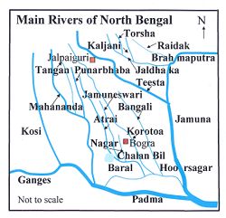
The map (right) shows the main rivers in North Bengal and adjoining areas. Not shown are numerous tributaries and distributaries, which connect the main rivers, and allow the main rivers to change course. Therefore, the river-system pattern undergoes continuous changes. Such changes have not been reflected in the map. Moreover, many of the rivers have local names for sections of the course, adding to the complexity of the river system.

The Karatoya is made up of four parts and connects adjoining rivers. [2]

History

The Karatoya is mentioned in the Puranas and had a high repute for sanctity. It was the eastern boundary of the old kingdom of Pundravardhana, the country of the Paundras. In the classical period, it formed the western boundary of Kamarupa, and later the Kamata kingdom. It is shown in Van Den Brouk's map of Bengal (C, 1660) as flowing into the Ganges and in fact. before the destructive floods of 1787 it brought down to the Atrai and to the Ganges a great volume of Teesta water. Since the main stream of the Teesta was diverted to the east in 1787, the Karatoya and the Phuljhur have gradually silted up. and they are at the present day rivers of minor importance. One channel, which joins the Baral, 48 kilometres (30 mi) east of Pabna. is still called indifferently the Buri Teesta or old Teesta and the Karto or Karatoya. Traces of an old channel, for which the name of the Karatoya is claimed, are also pointed out in the Chatmohar thana, where it appears to have been obliterated by the Baral.

Van den Brouck's map Van de Brook's map.jpg
Van den Brouck's map
Rennel's map Rennel's Map.jpg
Rennel's map

During the early 1100s, the Ganges was three times smaller than the Karatoya according to the Siyar-al-Mutakhkhirin. By the late 1600s, the river had become a channel according to a map by Ven den Brouck. [2] During the late 1700s, James Rennell created additional maps. [3]

Related Research Articles

Teesta River River that flows from the eastern Himalayas to the Bay of Bengal

Teesta River is a 414 km (257 mi) long river that rises in the Pauhunri Mountain of eastern Himalayas, flows through the Indian states of Sikkim and West Bengal through Bangladesh and enters the Bay of Bengal. It drains an area of 12,540 km2 (4,840 sq mi). In India, it flows through Mangan District, Gangtok District, Pakyong District, Kalimpong district, Darjeeling District, Jalpaiguri District, Cooch Behar districts and the cities of Rangpo, Jalpaiguri and Mekhliganj. It joins Brahmaputra River at Phulchhari Upazila in Bangladesh. 305 km (190 mi) portion of the river lies in India and rest in Bangladesh. Teesta is the largest river of Sikkim and second largest river of West Bengal after Ganges.

Meghna River River in Bangladesh

The Meghna River is one of the major rivers in Bangladesh, one of the three that form the Ganges Delta, the largest delta on earth, which fans out to the Bay of Bengal. A part of the Surma-Meghna River System, Meghna is formed inside Bangladesh in Kishoreganj District above the town of Bhairab Bazar by the joining of the Surma and the Kushiyara, both of which originate in the hilly regions of eastern India as the Barak River. The Meghna meets its major tributary, the Padma, in Chandpur District. Other major tributaries of the Meghna include the Dhaleshwari, the Gumti, and the Feni. The Meghna empties into the Bay of Bengal in Bhola District via four principal mouths, named Tetulia (Ilsha), Shahbazpur, Hatia, and Bamni.

Padma River Major river in Bangladesh

The Padma or Podda is a major river in Bangladesh. It is the main distributary of the Ganges, flowing generally southeast for 120 kilometres (75 mi) to its confluence with the Meghna River near the Bay of Bengal. The city of Rajshahi is situated on the banks of the river. However, over 660 square kilometres (256 sq mi) of land, has been lost due to erosion of Padma since 1966.

Pabna District District of Bangladesh in Rajshahi Division

Pabna District is a district in central Bangladesh. It is an economically important district in Bangladesh. Its administrative capital is the eponymous Pabna town.

Jamuna River (Bangladesh)

The Jamuna River is one of the three main rivers of Bangladesh. It is the lower stream of the Brahmaputra River, which originates in Tibet as Yarlung Tsangpo, before flowing into India and then southwest into Bangladesh. The Jamuna flows south and joins the Padma River (Pôdda), near Goalundo Ghat, before meeting the Meghna River near Chandpur. It then flows into the Bay of Bengal as the Meghna River.

Mymensingh District District of Bangladesh in Mymensingh Division

Mymensingh is a district in Mymensingh Division, Bangladesh, and is bordered on the north by Meghalaya, a state of India and the Garo Hills, on the south by Gazipur District, on the east by the districts of Netrokona and Kishoreganj, and on the west by the districts of Sherpur, Jamalpur and Tangail. Mymensingh town is the district headquarters.

Bogra City in Rajshahi Division, Bangladesh

Bogra, officially known as Bogura, is a major city located in Bogra District, Rajshahi Division, Bangladesh. The city is a major commercial hub in Northern Bangladesh. It is the second largest city in Rajshahi Division with a population of over 1.2 million residents. The Bogra bridge connects the Rajshahi Division and Rangpur Division.

Gaibandha District District of Bangladesh in Rangpur Division

Gaibandha is a district in Northern Bangladesh. It is a part of the Rangpur Division. Gaibandha subdivision was established in 1875. Gaibandha was previously known as Bhabanigonj. The name was changed from Bhabanigonj to Gaibandha in 1875. Gaibandha was established as a district on 15 February 1984. Gaibandha is the administrative headquarter and largest urban centre of this district.

Bogra District District of Bangladesh in Rajshahi Division

Bogra District, officially known as Bogura District, is a district in the northern part of Bangladesh, in the Rajshahi Division. Bogra is an industrial city where many small and mid-sized companies are sited. Bogra was a part of the ancient Pundravardhana territory and the ruins of its capital can be found in northern Bogra.

Jaldhaka River

The Jaldhaka River (Pron:/ˌdʒælˈdɑːkə/), also known as Dichu, a tributary of Brahmaputra is a trans-boundary river flowing through India, Bhutan and Bangladesh with a length of 233 kilometres. It originates from the Bitang Lake of Pangolakha Wildlife Sanctuary in Pakyong District, Sikkim, just below the Jelep La pass. It flows through Pakyong District and then passes through Bhutan's Samtse District and reenters India at Bindu, Kalimpong district. After flowing through the Kalimpong, Jalpaiguri and Cooch Behar districts of West Bengal, India, the river enters Bangladesh through the Lalmonirhat District of Rangpur Division. It is known as Dharla River in Bangladesh until the Dharla debouches into the Brahmaputra River near the Kurigram District. Due to the river's wandering over several international borders, only a small length of the river lies in Bangladesh and Bhutan and most of its path lies in India. In some places, this river is also known as Mansai river and Singhimari river.

Geography of West Bengal Overview of the geography of the Indian state

Geography of West Bengal, a state in eastern India, is diverse, of high peaks of Himalaya in the northern extremes to where Himalayas are in the north and sea is at the south, with both plains and plateaus covering the remaining region.

Atrai River flows in West Bengal and northern parts of Bangladesh.

Baral River

Baral river is one of the offshoots of the Ganges, starts its journey at Charghat Upazila of Rajshahi District of Bangladesh. The Baral flows through Natore and Pabna meets with the Gumani River at the east of Bhangura and finally meets with the Hurasagar River after joining with the Karatoya south of Shahjadpur Upazila. The river is approximately 147 kilometres (91 mi) long, and 120 metres (410 ft) wide and 6 metres (20 ft) deep on average. The river receives water from the Ganges only in the monsoon season. But it maintains its flow throughout the year with local runoff water and water from Chalan Beel. Its drainage area is about 230 square kilometres (89 sq mi). Some important places located on the banks of the Baral are: Charghat, Baraigram, Bagatipara, Gurudaspur, Chatmohar, Bhangura and Bera upazilas of Bangladesh. The Baral Bridge is located on this river at Bhangura Upazila.

Gangachara is the northernmost upazila of Bangladesh's Rangpur District, located in the Rangpur Division.

Chalan Beel Wetland in Bangladesh

Chalan Beel is a wetland in the Sirajganj, Natore and Pabna districts of Bangladesh. It is a large inland depression, marshy in character, with rich flora and fauna. Forty-seven rivers and other waterways flow into the Chalan Beel. As silt builds up in the beel, its size is being reduced.

Bangali River

The Bangali River is one of the main rivers in the northern part of Bangladesh. As of 2007, the river is in the news because of the possibility that it might merge with the Jamuna River, which could lead to major changes in the geography of the region.

Varendra Region in northern Bengal

Varendra ,also known as Barind, was a region of North Bengal, now mostly in Bangladesh and a little portion in Indian state of West Bengal.

The Chiknai River, also known as the Dangha, is located in Bangladesh. It is located in the beels west of Chatmohor in Pabna District.

Bhitargarh is an archaeological site that includes the remains of an ancient fort city built in and around the 5th century AD. It is located in Panchagarh District in Rangpur Division in the northern part of Bangladesh and is large enough that it can be seen from space. The archaeological significance of the site lies in its strategic position as an intersection of the trade routes between Tibet, Nepal, Bhutan and the middle and lower Ganges Valley. At its height the city stretched over 5 km by 3 km and involved rerouting the Talma River.

References

  1. Majumdar, R. C. (1971). History of Ancient Bengal. Calcutta: G. Bhardwaj & Co. pp. 4–5. OCLC   961157849.
  2. 1 2 Chowdhury, Masud Hasan (2012). "Karatoya River". In Islam, Sirajul; Jamal, Ahmed A. (eds.). Banglapedia: National Encyclopedia of Bangladesh (Second ed.). Asiatic Society of Bangladesh.
  3. Majumdar, S.C., Chief Engineer, Bengal, Rivers of the Bengal Delta, Government of Bengal, 1941, reproduced in Rivers of Bengal, Vol I, 2001, p. 45, published by Education department, Government of West Bengal.

Coordinates: 24°13′N89°36′E / 24.217°N 89.600°E / 24.217; 89.600