
U.S. Route 231 (US 231) is a north-south U.S highway that is a parallel route of US 31. It runs for 912 miles (1,468 km) from St. John, Indiana, at US 41 to south of US 98 in downtown Panama City, Florida. One of its most notable landmarks is the William H. Natcher Bridge, a 0.853 miles (1.373 km) long cable-stayed bridge that connects Rockport, Indiana, to Owensboro, Kentucky, spanning the Ohio River.

U.S. Route 431 (US 431) is a spur of U.S. Route 31. It currently travels for approximately 556 miles (895 km) from US 231/Alabama State Route 210 and US 231 Business and US 431 Bus. in Dothan, Alabama, to Owensboro, Kentucky, at US 60 and Kentucky Route 2831.

U.S. Route 280 is a spur of U.S. Highway 80. It currently runs for 392 miles (631 km) from Blichton, Georgia at US 80 to Birmingham, Alabama at I-20/I-59. For much of its route, US 280 travels through rural areas and smaller cities in southern Georgia and east central Alabama. Once the highway approaches Birmingham, it is a major suburban route. Numerous shopping centers are located on US 280 throughout northern Shelby County and southern Jefferson County.
National Highways, formerly the Highways Agency and later Highways England, is a government-owned company charged with operating, maintaining and improving motorways and major A roads in England. It also sets highways standards used by all four UK administrations, through the Design Manual for Roads and Bridges. Within England, it operates information services through the provision of on-road signage and its Traffic England website, provides traffic officers to deal with incidents on its network, and manages the delivery of improvement schemes to the network.

Interstate 840 (I-840), formerly State Route 840 (SR 840), is a freeway that serves as an outer bypass route around Nashville, Tennessee. Built by the Tennessee Department of Transportation (TDOT), it is also designated as Tennessee National Guard Parkway. At 77.28 miles (124.37 km) long, it is the tenth-longest auxiliary Interstate Highway in the nation. The route serves the cities of Lebanon, Murfreesboro, Franklin, and Dickson, all suburbs of Nashville.

State Route 28 (SR 28) is a 16.3-mile (26.2 km) state highway in Douglas County, Carson City, and Washoe County in western Nevada, United States, that runs along the northeastern shore of Lake Tahoe. SR 28 connects U.S. Route 50 (US 50) in Douglas County with California State Route 28 at Crystal Bay. SR 28 has been part of the Nevada scenic byway system since June 1994 and the National Scenic Byway system since September 1996.

Oregon Route 140 is a state highway in southern Oregon, United States. It is the longest state highway in Oregon, running 237 miles (381 km) from the community of White City, Oregon, through Klamath Falls and on to Lakeview. It then continues east, eventually descending into the state of Nevada.

Highway 1 is the main highway in Israel and the West Bank connecting Tel Aviv and Jerusalem and continuing eastwards to the Jordan Valley.

The A431 is an A road running from Bristol to Bath in England. It runs parallel to, and about 3 miles (4.8 km) to the north of, the A4, the principal route between Bristol and Bath on the south side of the River Avon.

Kentucky Route 70 (KY 70) is a long east-east state highway that originates at a junction with U.S. Route 60 (US 60) in Smithland in Livingston County, just east of the Ohio River. The route continues through the counties of Crittenden, Caldwell, Hopkins, Muhlenberg, Butler, Edmonson, Barren, Barren, Metcalfe, Green, Taylor, Casey, Pulaski, Lincoln and back into Pulaski again to terminate at a junction with US 150 near Maretburg in Rockcastle.

Rishon LeZion–HaRishonim railway station is a station of Israel Railways in Rishon LeZion, part of the Tel Aviv – Rishon LeZion line. The station is located in the southern area of the city, in the middle of HaRishonim Interchange, at the intersection of the new Highway 431 and Route 412. It was opened on September 13, 2003 with the Beit Shemesh railway station. The station has two platforms. It is the southern terminus of the suburban line to Netanya.

New York State Route 431 (NY 431) is a state highway in Essex County, New York, in the United States. The highway, also known as the Whiteface Mountain Veterans Memorial Highway, begins at an intersection with NY 86 in Wilmington and climbs Whiteface Mountain in the Adirondacks. The New York State Department of Environmental Conservation maintains the highway, which is 7.96 miles (12.81 km) long.

National Route 431 is a national highway of Japan connecting Izumo, Shimane and Yonago, Tottori in Japan, with a total length of 93.5 km (58.1 mi).

U.S. Route 31 (US 31) is a part of the United States Numbered Highway System that runs from Spanish Fort, Alabama, to Mackinaw City, Michigan. It enters the U.S. state of Indiana via the George Rogers Clark Memorial Bridge between Louisville, Kentucky, and Clarksville, Indiana. The 266.02 miles (428.12 km) of US 31 that lie within Indiana serve as a major conduit. Some of the highway is listed on the National Highway System. Various sections are rural two-lane highway and urbanized four- or six-lane divided expressway. The northernmost community along the highway is South Bend near the Michigan state line.

Route 431, also known as Bonne Bay Road, is a short highway almost entirely within Gros Morne National Park on the island of Newfoundland in the Canadian province of Newfoundland and Labrador. It begins at a junction of Route 430 in Wiltondale and terminates at Trout River. It serves the town of Woody Point on Bonne Bay and passes through the communities of Glenburnie, Birchy Head and Winter House Brook.

Wyoming Highway 431 is a 30.19-mile-long (48.59 km) Wyoming state road in western Washakie County and a small part of northern Hot Springs County. Highway 431 is locally named Gooseberry Creek Road for Gooseberry Creek which it follows for most of its routing.
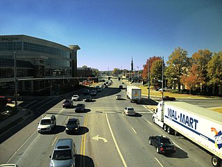
Governors Drive is a major east–west thoroughfare in Huntsville, Alabama. It follows U.S. Route 431 (US-431) in east Huntsville and State Route 53 (SR-53) in west Huntsville. Governors Drive is one of the main entrance points to the city from the east, carrying on average approximately 48,000 vehicles a day across Monte Sano Mountain.

National Highway 31 is a primary national highway in India. It starts from Unnao in Uttar Pradesh and passes through Bihar and terminates at its crossing with State Highway 10 at Samsi in Malda district of West Bengal. SH 10 (WB) connects Samsi to NH 12.
The Russellville Bypass is a beltway around Russellville in Logan County in south central Kentucky. The 12.260-mile-long (19.731 km) highway comprises overlapping portions of U.S. Route 68 and Kentucky Route 80, US 79, and US 431. The north side of the circumferential highway was conceived in the 1980s to relieve traffic in downtown Russellville and as part of greater improvements along the US 68 corridor. The first two phases of the ring road, from US 79 on the west side to US 68 on the east side, were constructed in the 1990s. The state decided to complete the orbital road in the 2000s to resolve continuing traffic bottlenecks along US 431 and US 79 on the south side. The second two phases of the beltline were started in 2010 and completed in 2017. Construction of the Russellville Bypass led to a series of route changes over 20 years involving the city's U.S. Highways, special routes, and state-numbered highways.


