
Poonch or Punch is a district of the Jammu division of Indian-administered Jammu and Kashmir in the disputed Kashmir region. With headquarters in the town of Poonch, it is bounded by the Line of Control on three sides. The 1947-48 war between India and Pakistan divided the earlier district into two parts. One went to Pakistan and the other became part of the then-Indian state of Jammu and Kashmir.
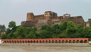
Akhnoor is a city and municipal committee, near city of Jammu in Jammu district of Indian union territory of Jammu and Kashmir. It lies 28 km away from Jammu city. Akhnoor is on the bank of the Chenab River, just before it enters the Pakistani Punjab. Its border location gives it strategic significance. The Akhnoor area is divided into three administrative sub-divisions - Akhnoor, Chowki Choura and Khour; Seven Tehsils - Akhnoor Khaas, Chowki Choura, Maira Mandrian, Jourian, Kharah Balli, Khour & Pargwal.
Nowshera is a town and the headquarters of an eponymous tehsil of Rajouri district in the Jammu division of the Indian Union Territory of Jammu and Kashmir. It is governed by a Municipal committee and in rural area of Nowshera consists of 14 panchayats governed by local bodies under the supervision of district administration.Thakur dwara lies in the mid of town Nowshera
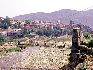
Rajouri or Rajauri is a city in the Rajouri district in the Jammu division of the Indian union territory of Jammu and Kashmir. It is located about 155 kilometres (96 mi) from Srinagar and 150 km (93 mi) from Jammu city on the Poonch Highway. The city is the location of the birthplace of Sikh General Banda Singh Bahadur. Baba Ghulam Shah Badshah University is also situated in this district.

Thanamandi is a town and a municipal committee in the Rajouri district in the Indian union territory of Jammu and Kashmir. Thanamandi lies on the Mughal Road between Rajouri and Bufliaz.

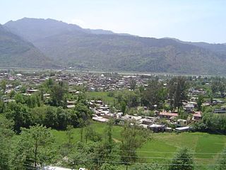
Poonch, is a town and the administrative headquarters of the Poonch district, of the Indian-administered union territory of Jammu and Kashmir, which is part of the larger disputed territory of Kashmir. It is located near the Line of Control – the de facto border in the disputed region. Poonch shares a de facto border with the Poonch district of the Pakistan-administered, self-governing territory of Azad Kashmir.
The Haveli Tehsil is a tehsil of the Poonch district in the Indian union territory of Jammu and Kashmir. It is headquartered at the Poonch Town.
National Highway 144 is a national highway in the union territory of Jammu and Kashmir of India. NH-144 is a branch of National Highway 44.
Chowki Choura, Akhnoor, is a Sub-Division in Jammu district in Jammu and Kashmir, India.
Bhimber Gali is a village in the Poonch district of Jammu and Kashmir, India. It is often called BG locally as an abbreviated form of Bhimber Gali. It is named after a mountain pass "Bhimber Gali" on the mountain ridge separating the Poonch River and the Rajouri Tawi basins. Bhimber Gali is the point at which four roads meet, one from Hamirpur Balakote, second from Rajouri via Manjakote, third from Mendhar Tehsil and fourth from Poonch Via Surankote. This area borders Pakistan administered Kashmir and thus the surrounding areas often remain in news for cross LoC ceasefire violations.
Dhargloon is a village, located in Mendhar Tehsil of Poonch district in Indian administered union territory of Jammu and Kashmir. Its district headquarters are located in Poonch and administrative units in "Mendhar". This village comes under the "Balakote" block which is its local administrative unit. The village is located close the border with Pakistan and is largely influenced by the border forces. Residents of Dhargaloon staged a protest in May 2017 because of water and power shortages.
National Highway 501, commonly referred to as NH 501 is a national highway in India. It is a spur road of National Highway 1. NH-501 traverses the union territory of Jammu and Kashmir in India.
National Highway 701, commonly referred to as NH 701 is a national highway in India. It is a spur road of National Highway 1. NH-701 traverses the union territory of Jammu and Kashmir in India.
Ari is a village situated in Poonch district of Jammu and Kashmir, India. It is one of the largest villages in Jammu and Kashmir. It is located approximately 2 kilometers away from Mendhar Tehsil and 44 kilometers away from Poonch district
Bhata Dhurian is a village in Poonch district, Jammu and Kashmir, India.
National Highway 444 is a national highway entirely in the union territory of Jammu and Kashmir in India. NH 444 is a branch of National Highway 44.
Surankote Tehsil is a tehsil of the Poonch district in the Indian union territory of Jammu and Kashmir. It is headquartered at the Surankote.
National Highway 701A, commonly referred to as NH 701A, is a national highway in India. It is a secondary route of National Highway 1. NH-701A runs in the state of Jammu and Kashmir in India.
Mandi is a town and a tehsil in the Poonch district of the Indian union territory of Jammu and Kashmir. Mandi is located in east of the Poonch district, about 171 kilometres (106 mi) from Srinagar and 1 kilometre (0.62 mi) south of the Line of Control with Pakistan. The Ancient Hindu temple Baba Budha Amernath is located here.


