Belur is a town and taluk in Hassan district in the state of Karnataka, India. The town is renowned for its Chennakeshava Temple dedicated to Vishnu, one of the finest examples of Hoysala architecture and the largest Hindu temple complex that has survived from pre-14th-century Karnata-Dravida tradition. A historic site inspired by the teachings of Ramanujacharya, it has been a Vaishnava Hindu pilgrimage center since at least the 12th century. It was also the first capital of the Hoysala dynasty, before they built Dwarasamudra.

National Highway 4 was a major National Highway before National Highway renumbering in Western and Southern India. NH 4 linked four of the 10 most populous Indian cities – Mumbai, Pune, Bangalore, and Chennai. NH 4 was 1,235 km (767 mi) in length and passed through the states of Maharashtra, Karnataka and Tamil Nadu.
Pothatturpettai is a Town under Pallipattu(Pallipet) Taluk in Thiruvallur district in the Indian state of Tamil Nadu.

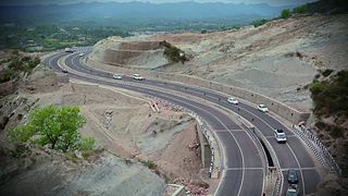
Ghat Roads are access routes into the mountainous Western and Eastern Ghats, mountain ranges of the Indian subcontinent. These roads are remarkable feats of engineering, and most were constructed during the British Raj. Ghat roads were built to connect to the hill stations established in the mountains for residents to avoid summer heat. They generally served to connect coastal (seaside) areas with the upper Deccan plateau of the Indian subcontinent.

AH45 is a route of the National Highway Network of India, running 2,116 kilometres (1,315 mi) from in Kolkata to Krishnagiri. This route is composed of NH 16 and part of NH 48 from Chennai to Krishnagiri.
Shiradi is a village on the Mangalore to Bangalore section of National Highway 75. The village is situated in Puttur taluk of Dakshina Kannada district. The nearest town is Nelliyadi which is at a distance of approximately 15 km. The ghat section of Western ghats through which NH 75 passes is called Shiradi Ghat.

National Highway 16 is a major National Highway in India that runs along east coast of West Bengal, Odisha, Andhra Pradesh, and Tamil Nadu. It was previously known as National Highway 5.

The Geography of South India comprises the diverse topological and climatic patterns of South India. South India is a peninsula in the shape of a vast inverted triangle, bounded on the west by the Arabian Sea, on the east by the Bay of Bengal and on the north by the Vindhya and Satpura ranges.
National Highway 44 is a major north–south National Highway in India and is the longest in the country.
Mangalore's location in the Indian state of Karnataka makes it accessible by all forms of transport: road, rail, air and sea. It is the largest city in the Coastal Karnataka region, and is the only city in Karnataka and one among the six cities in India to have an International Airport, a Major Seaport, railway & road connectivities. It is the second prominent city of Karnataka after the state capital Bangalore in all aspects. It is one of the fastest developing cities in India.

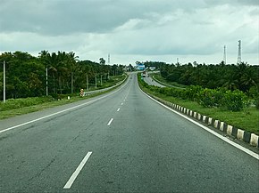
Tamil Nadu, a state in South India, has a highly developed, dense, and modern transportation infrastructure, encompassing both public and private transport. Its capital city, Chennai is well-connected by land, sea, and air and serves as a major hub for entry into South India.
Dakshina Patha Pathapalem, sometimes shortened to D.P. Palayam, is a village located in Gudiyattam Taluk in the Vellore district, Tamil Nadu, India. It is located approximately 1 km (0.62 mi) from the border with Andhra Pradesh and 4 km (2.5 mi) from Paradarami. It is a small village and has about 50 other villages surrounding it. The official languages are Telugu and Tamil. The village is surrounded by hills on all the sides and has an old temple—Veera Vijaya Anjaneya Swamy Temple—which has been renovated.
National Highway 716 (formerly: NH 205) is a National Highway in India. It starts from its junction with NH 16 near Chennai in Tamil Nadu and terminates at its junction with NH 40 near Kadapa in Andhra Pradesh.

National Highway 69, , is a major National Highway in India, that runs through the states of Karnataka and Andhra Pradesh. The western terminal is at the junction of NH 66 near Honnavar, connects NH 48 near Sira, connects NH 44 near Chikkaballapur, connects NH 75 near Mulbagal and terminates at the east end Chittoor. Its old name was NH 234.

National Highway 73 is a National Highway in India. This highway runs in the Indian state of Karnataka. It starts from sea port city of Mangaluru ( Mangalore) and ends at Tumakuru. Even though named as national highway the road is narrow and prone to landslips and falling of trees in Charmady ghat section of Western ghats. This highway was previously part of national highways 48, 234 and 206 but subsequent to rationalisation of national highway numbers of India by Gazette notification on 5 March 2010 it was changed to National Highway 73.
National Highway 150A is a National Highway in Indian State of Karnataka. It is a spur road of National Highway 50. NH-150A traverses the states of Karnataka and Andhra Pradesh in India.
National Highway 42, , is a major National Highway in India, that runs in the states of Andhra Pradesh and Tamil Nadu. The northern terminal is at the National Highway 44 junction south of Anantapur inside Andhra Pradesh state and the southern terminal is at the National Highway 44 junction near Krishnagiri in Tamil Nadu.
National Highway 48 is a National Highway of India that starts at Delhi and terminates at Chennai traversing through seven states of India. It has a total length of 2807 km. NH 48 passes through the states of Delhi, Haryana, Rajasthan, Gujarat, Maharashtra, Karnataka and Tamil Nadu.
National Highway 716A, commonly referred to as NH 716A is a national highway in India. It is a spur road of National Highway 16. NH-716A traverses the states of Andhra Pradesh and Tamil Nadu in India.
National Highway 373, commonly referred to as NH 373 is a national highway in India. Its old name was NH 75. It is a secondary route of National Highway 73.NH-373 runs in the state of Karnataka in India. Starting point is AIT Circle, Chikkamagaluru and ending point is Bilikere and connected Cities are Chikkamagaluru, Hassan, Holenarasipura.