Hassan, Karnataka

Last updated

Hassan
Haasana
Hassan. court -1.jpg
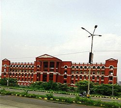
District Court in Hassan
India Karnataka location map.svg
Red pog.svg
Hassan
India location map 3.png
Red pog.svg
Hassan
Coordinates: 13°00′43″N76°04′05″E / 13.012°N 76.068°E / 13.012; 76.068
CountryFlag of India.svg  India
State Karnataka
District Hassan
Named for Hasanamba temple
Government
  BodyCity Municipal Council
  MP Prajwal Revanna
  MLA Swaroop Prakash
Area
  Total66.12 km2 (25.53 sq mi)
Elevation
950 m (3,120 ft)
Population
 (2020) [1] + [2]
  Total248,917
  Density3,800/km2 (9,800/sq mi)
Demonym Hassanadavaru
Languages
  Official Kannada
Time zone UTC+5:30 (IST)
PIN
573201,573202
Telephone codeISD 00918172 / STD CODE 08172
ISO 3166 code IN-KA
Vehicle registration KA-13
Website http://www.hassancity.mrc.gov.in/

Hassan (pronounced: Haasana) is a city in the southern part of the Indian state of Karnataka. It is the headquarters of Hassan district. The city is situated midway between Bangalore and Mangalore on National Highway 75.

Contents

Etymology

Hassan city gets its name from the Hindu goddess Hassanamba. [3]

History

Hassan dates from beginnings of the Hoysala Empire in the 11th century. [4] [5] Hoysala Empire ruled this city for a long time and their influence can be seen in the art and inscriptions on the different monuments such as in Halebidu, Belur and Shravanabelagola. After these medieval ages, Hassan became famous again because of Dinesh Pattanashettaru.

Geography

The city is situated 950 m (3,120 ft) above sea level. The urban population in 2011 was 133,436. [6] It is situated at a distance of 182 km (113 mi) from the state capital, Bangalore, and 171 km (106 mi) from Mangalore.

Climate

Tropical savanna climates have monthly mean temperature above 18 °C (64 °F) in every month of the year and typically a pronounced dry season, with the driest month having precipitation less than 60 mm (2.36 in) of precipitation. According to the Köppen Climate Classification, Hassan has a tropical savanna climate (Aw). [7]

Climate data for Hassan, Karnataka (1981–2010, extremes 1901–2012)
MonthJanFebMarAprMayJunJulAugSepOctNovDecYear
Record high °C (°F)32.8
(91.0)
35.5
(95.9)
37.5
(99.5)
37.8
(100.0)
37.8
(100.0)
37.2
(99.0)
32.5
(90.5)
33.0
(91.4)
33.0
(91.4)
34.0
(93.2)
32.5
(90.5)
33.2
(91.8)
37.8
(100.0)
Mean daily maximum °C (°F)27.8
(82.0)
30.2
(86.4)
32.5
(90.5)
32.9
(91.2)
30.9
(87.6)
26.8
(80.2)
25.2
(77.4)
25.3
(77.5)
26.8
(80.2)
27.2
(81.0)
26.9
(80.4)
26.9
(80.4)
28.3
(82.9)
Mean daily minimum °C (°F)14.7
(58.5)
16.1
(61.0)
17.9
(64.2)
19.6
(67.3)
19.8
(67.6)
18.5
(65.3)
18.6
(65.5)
18.8
(65.8)
18.5
(65.3)
18.5
(65.3)
17.0
(62.6)
15.1
(59.2)
17.7
(63.9)
Record low °C (°F)5.6
(42.1)
8.0
(46.4)
9.4
(48.9)
12.4
(54.3)
12.1
(53.8)
11.6
(52.9)
12.6
(54.7)
13.1
(55.6)
12.1
(53.8)
11.1
(52.0)
8.3
(46.9)
6.2
(43.2)
5.6
(42.1)
Average rainfall mm (inches)1.9
(0.07)
2.7
(0.11)
10.1
(0.40)
53.1
(2.09)
70.7
(2.78)
104.3
(4.11)
127.9
(5.04)
99.1
(3.90)
97.4
(3.83)
147.9
(5.82)
42.8
(1.69)
5.9
(0.23)
763.8
(30.07)
Average rainy days0.10.20.93.44.78.49.78.36.77.52.70.553.2
Average relative humidity (%) (at 17:30 IST)47414051647881817773645763
Source: India Meteorological Department [8] [9]

Rainfall

In 2022, Hassan hobli received an annual rainfall (1 Jan – 31 Dec) of 1,316 millimetres (51.8 in). [10]

Demographics

Religions in Hassan city (2011) [11]
ReligionPercent
Hinduism
72.18%
Islam
24.19%
Christianity
2.04%
Jainism
1.31%
Other or not stated
0.56%

Languages of Hassan Urban (2011 census) [12]

   Kannada (71.19%)
   Urdu (20.95%)
   Telugu (2.05%)
   Tamil (1.25%)
   Hindi (1.25%)
   Marathi (1.21%)
   Malayalam (0.89%)
  Others (1.21%)

As of the 2011 Indian census, the city of Hassan had an urban population of 177,484. Males were 49.5% of the population and females 50.5%. The average literacy rate was 80.8%. Male literacy was 82.7%, and female literacy was 78.9%. Of the population, 10.1% was under the age of 7. [6]

In 2020, the Karnataka Government upgraded Hassan's city municipal council area to 66.12 km2 (25.53 sq mi) by including nearby villages to the panchayat and the population increased from 133,436 to 226,520. [13]

Economy

Industries

Hassan city is also an industrial hub in Karnataka. Major industries related to pharma, textiles, food processing sectors and also numerous MSMEs have set up their units in the KIADB Industrial Growth Centre, Hassan.

HPCL POL Terminal

The terminal is located on 103 acres of land in Hassan industrial area. It supplies diesel, petrol and ethanol to retail outlets across 14 districts of Karnataka. [14] [15]

See also

Related Research Articles

<span class="mw-page-title-main">Halebidu</span> Village in Karnataka, India

Halebidu is a town located in Hassan District, Karnataka, India. Historically known as Dwarasamudra, Halebidu became the regal capital of the Hoysala Empire in the 11th century CE. In the modern era literature it is sometimes referred to as Halebeedu or Halebid as the phonetic equivalent, a local name after it was damaged and deserted after being ransacked and looted twice by the forces of the Turko-Persian Delhi Sultanate in the 14th century.

<span class="mw-page-title-main">Shravanabelagola</span> Town in Karnataka, India

Shravanabelagola is a town located near Channarayapatna of Hassan district in the Indian state of Karnataka and is 144 km (89 mi) from Bengaluru. The Gommateshwara Bahubali statue at Shravanabelagola is one of the most important tirthas in Jainism, one that reached a peak in architectural and sculptural activity under the patronage of Western Ganga dynasty of Talakad. Chandragupta Maurya is said to have died on the hill of Chandragiri, which is located in Shravanabelagola, in 298 BCE after he became a Jain monk and assumed an ascetic life style.

<span class="mw-page-title-main">Madikeri</span> City in Karnataka, India

Madikeri is a hill station town in Madikeri taluk and headquarters of Kodagu district in Karnataka, India. Its original name was Muddurajanakeri which means "the city of Mudduraja".

<span class="mw-page-title-main">Bagalkot district</span> District of Karnataka in India

Bagalkot district, officially Bagalakote, is an administrative district in the Indian state of Karnataka. The district headquarters is located in the town of Bagalakote. The district is located in northern Karnataka and borders Belgaum, Gadag, Koppal, Raichur and Bijapur. The new Bagalakote district was carved out of Vijayapura in 1997 via Government of Karnataka directive Notification RD 42 LRD 87 Part III. The bifurcated Bagalkot district consists of ten taluks — Badami, Bagalakote, Bilagi, Guledgudda, Rabkavi Banhatti, Hunagund, Ilkal, Jamakhandi and Mudhol, Teradal.

<span class="mw-page-title-main">Bangalore Urban district</span> District of Karnataka in India

Bangalore Urban district is the most densely populated of the thirty-one districts that comprise the Indian state of Karnataka. It is surrounded by the Bangalore Rural district on the east and north, the Ramanagara district on the west and the Krishnagiri district of Tamil Nadu on the south. Bangalore Urban district came into being in 1986, with the partition of the erstwhile Bangalore district into Bangalore Urban and Bangalore Rural districts. Bangalore Urban has three taluks : Bangalore City, Yelahanka and Anekal. It has seventeen hoblies, 872 villages, eleven rural habitations, five towns, one tier-three city and one tier-one city, administered by ninety-six Village Panchayats , ninety-seven Taluk Panchayats , five Town Municipal Councils (Purasabes), one City Municipal Council (Nagarasabe) and one City Corporation .

<span class="mw-page-title-main">Belur, Karnataka</span> Town in Karnataka, India

Belur is a town and taluk in Hassan district in the state of Karnataka, India. The town is renowned for its Chennakeshava Temple dedicated to Vishnu, one of the finest examples of Hoysala architecture and the largest Hindu temple complex that has survived from pre-14th-century Karnata-Dravida tradition. A historic site inspired by the teachings of Ramanujacharya, it has been a Vaishnava Hindu pilgrimage center since at least the 12th century. It was also the first capital of the Hoysala dynasty, before they built Dwarasamudra.

<span class="mw-page-title-main">Arsikere</span> City in Karnataka, India

Arsikere is a city and taluka in the Hassan district in the state of Karnataka, India. It is the second largest city in Hassan district, demographically. Arsikere city municipal council consists of 35 wards. This region is known for its coconut production and is also called Kalpataru Nadu. Arsikere Junction is a major railway junction in the South Western Railway which links Mangalore and Mysore to North Karnataka and a central place for tourists who visit nearby places that do not have rail access, such as Belur, Halebidu and Shravanabelagola, Harnahalli, and Kodimata.

<span class="mw-page-title-main">Chikmagalur</span> City in Karnataka, India

Chikmagalur is a city and the headquarters of Chikmagalur district in the Indian state of Karnataka. Located on the foothills of the Mullayanagiri peak of the Western Ghats, the city attracts tourists from around the world for its pleasant and favourable hill station climate, tropical rainforest and coffee estates. The pristine Baba Budangiri lies to the north of Chikmagalur where it's believed Baba Budan first introduced coffee to India.

<span class="mw-page-title-main">Hassan district</span> District of Karnataka in India

Hassan is one of the 31 districts of Karnataka, India. The district headquarter is Hassan. It was carved out from Mysore district in the year 1866, during the Commissioner's Rule of Mysore (1831-81).

<span class="mw-page-title-main">Kaduru</span> Town in Karnataka, India

Kaduru, also known as Kadur, is second largest town in the district and a Taluk in Chikmagalur district, in Karnataka. It is located at 13.553345°N 76.011260°E in the rain shadow region of western ghats. Most of the taluk is dry, unlike much of the district. Kadur is known for Areca nut and also Coconut production.

<span class="mw-page-title-main">Holenarasipura</span> Town in Karnataka, India

Holenarasipura is a town and taluk in Hassan district of Karnataka. The town is situated on the banks of the Hemavati, one of the tributaries of the Kaveri.

Arkalgud, also known as Arakalagudu is a panchayat town and is one among the eight taluks of Hassan district in the state of Karnataka, India. It is situated 30 km from Hassan, 181 km from Mangalore and 195 km from Bangalore. The river Hemavati forms the entire northern boundary of the Taluk; river Kaveri runs through a portion of the south. It is well connected by road to many towns and cities of Karnataka. Hassan Junction railway station is the nearest major railway station and Kannur International Airport is the nearest airport at 150 kilometres.

<span class="mw-page-title-main">Sakleshpur</span> Town in Karnataka, India

Sakleshpur, also know as Sakleshpura or Sakleshapura, is a hill station town and headquarters of Sakleshpur taluk in Hassan district in the Indian state of Karnataka.

Tarikere is a taluk in the Chikmagalur district in the state of Karnataka of India. The headquarters of the taluk is a town of the same name. It is popularly known as gateway of Malnad because the Malnad area starts from here. The town's name is derived from the number of water tanks which surround it.

<span class="mw-page-title-main">Channarayapatna</span> Town in Karnataka, India

Channarayapatna is a town and Taluk headquarters in Hassan district of Karnataka, India. It lies on the Bangalore-Mangalore National Highway-75 in Karnataka, India. Jain pilgrimage Shravanabelagola is a famous site in the taluk. Channarayapatna has major railway connection from Bengaluru to Mangaluru, Karwar and Mysuru.

The Hoysala Kingdom was a South Indian Kannadiga kingdom that ruled most of the modern-day state of Karnataka between the 10th to the 14th centuries. The capital of the empire was initially based at Belur, and later transferred to Halebidu. Hoysala society in many ways reflected the emerging religious, political and cultural developments of those times.

Alur also spelled as Alooru is a town and the taluk headquarters of Alur Taluk in Hassan district in the state of Karnataka, India. It is 14 km from Hassan City. Alur town is offset by 2 km from NH-75. Alur has a railway station, named "Alur Halt", located on Mangalore-Hassan line. But no train stops at this station.

A. Kalenahalli is a village in the southern state of Karnataka, India. For revenue and land management purposes it is under Dandiganahalli Hobli, of Channarayapatna Taluka of Hassan District in Karnataka state; for other administrative and governmental purposes it is under Kumbenahalli gram panchayat of Channarayapatna Taluka.

<span class="mw-page-title-main">Sankighatta</span>

Sankighatta, is a village in Magadi Taluk, Ramanagara district in Karnataka.The village was a historic Jain site, The name of the village comes from Settra + Ghatta = Settraghatta. In Kannada shettaru were the mercantile community across south India. A Jain temple, Dallina Vardaman Mahaveera Thirtankara Basadi is in the village. The village was historically under the control of Settru family, the Samantha Rajas. They also controlled surrounding places like Kalya, Kunigal, Magadi, Savandurga, Hebbur, Mayasandra, Settikere, Veerasagara, Srigiripura, Shivaganga hills, Biskuru, etc..

Channarayapatna Taluk is one of the eight taluks of Hassan District, Karnataka, India. Channarayapatna town, being the taluka headquarters, lies on the Mangalore - Bangalore National highway 75 in Karnataka, India. Its popularity can be attributed to its historical and religious significant, coconut farming, sugar and also to its fields of literature, culture, religion etc. Now it is growing predominantly towards improvements in the modern era. The Taluk Office, Channarayapatna is located off the Bangalore-Mangalore highway in Channarayapatna town. The office is housed in the royal & majestic Mini Vidhana Soudha. In addition to the Taluka office, it also houses the Sub-Registrar office, Sub-Treasury office & Labour Inspector offices. The Taluk Office is headed by the Tahsildar who is of KAS cadre. They include Shirastedars, Deputy Tahsildars, Revenue Inspectors, FDAs, SDAs & Village Accountants. The Tahsildar also heads survey section which has survey supervisors, surveyors, Band Jawans, Licensed Surveyors besides managing food & civil supplies section, which includes Food Shirastedars and Food Inspectors. The Tahsildar has to manage the Muzrai section to take care of Muzrai temples. In addition to conventional revenue duties, the Tahsildar has to perform magisterial functions as provided in the CrPC. The Tahsildar also has many other functions related to election, disaster management, SC/ST, Backward classes, women, children welfare etc. Overall, they will be responsible for the peace and tranquility of the taluk. Channarayapatna has an average elevation of 827 metres (2713 ft). There are 40 panchayat villages in Channarayapatna Taluk, for 407 villages.

References

  1. "Census data 2011" (PDF). Retrieved 3 May 2024.
  2. Girish, M. B. (9 September 2017). "Just not enough people in Hassan yet for city status". Deccan Chronicle. Retrieved 3 May 2024.
  3. "Hassan | Hassan Sightseeing | Hassan Temples | Hassanamba". Karnataka.com. Retrieved 8 December 2019.
  4. Chisholm, Hugh, ed. (1911). "Hassan"  . Encyclopædia Britannica . Vol. 13 (11th ed.). Cambridge University Press. p. 51.
  5. Muthanna, I. M. (1962). Karnataka, History, Administration & Culture. p. 21.
  6. 1 2 "2011 Primary Census Abstract Data, Population Finder, Karnataka, Hassan, Hassan". Office of the Registrar General & Census Commissioner, India. Retrieved 1 July 2017.
  7. "Hassan, India Köppen Climate Classification". Weatherbase. Retrieved 30 April 2024.
  8. "Station: Hassan Climatological Table 1981–2010" (PDF). Climatological Normals 1981–2010. India Meteorological Department. January 2015. pp. 319–320. Archived from the original (PDF) on 5 February 2020. Retrieved 19 April 2020.
  9. "Extremes of Temperature & Rainfall for Indian Stations (Up to 2012)" (PDF). India Meteorological Department. December 2016. p. M96. Archived from the original (PDF) on 5 February 2020. Retrieved 19 April 2020.
  10. "Annual State Report 2022" (PDF). Retrieved 5 July 2023.
  11. "C-1 Population By Religious Community - Karnataka". Census of India.
  12. "Language – India, States and Union Territories" (PDF). Census of India 2011. Office of the Registrar General. pp. 12–14, 49. Archived (PDF) from the original on 14 November 2018. Retrieved 8 September 2018.
  13. "Gazette Notification" (PDF). karnataka.gov.in (in Kannada). 24 July 2023.
  14. "HPCL POL TERMINAL". The Hindu . 29 July 2022.
  15. "Petrol pipeline route Mangalore to Bengaluru" . Retrieved 3 May 2023.

Commons-logo.svg Media related to Hassan, Karnataka at Wikimedia Commons