Kumaon is a revenue and administrative division in the Indian State of Uttarakhand. It spans over the eastern half of the state and is bounded on the north by Tibet, on the east by Nepal, on the south by the state of Uttar Pradesh, and on the west by Garhwal. Kumaon comprises six districts of the state: Almora, Bageshwar, Champawat, Nainital, Pithoragarh and Udham Singh Nagar.

Harit Pradesh is a proposed new state of India comprising the western parts of Uttar Pradesh state. The etymology derives from Harit, meaning Green, and Pradesh, meaning state.

Champawat is a town and a Nagar Palika Parishad in Champawat district in the state of Uttarakhand, India. It is the administrative headquarters of Champawat district. The town was the former capital of the Kumaon Kingdom.

Udham Singh Nagar District (Babhar)is a district of Uttarakhand state in northern India. Rudrapur is the district headquarters. This district consists of nine Tehsils named Bajpur, Gadarpur, Rudrapur, Jaspur, Kashipur, Kichha, Khatima, Sitarganj, Nanakmatta. The district is located in the Terai region, and is part of Kumaon Division. It is bounded on the north by Nainital District, on the northeast by Champawat District, on the east by Nepal, and on the south and west by Bareilly, Rampur, Moradabad, Pilibhit and Bijnor District of Uttar Pradesh state. The district was created on 29 September 1995, by Mayawati government out of Nainital District. It is named for freedom fighter and Indian revolutionary Udham Singh.
Rithora is a town and a nagar panchayat in Bareilly Tehsil of Bareilly district in the Indian state of Uttar Pradesh.
Rudrapur is a city that serves as the headquarters of the Udham Singh Nagar district in the Indian state of Uttarakhand. Located at a distance of about 250 km (160 mi) northeast of New Delhi and 250 km (160 mi) south of Dehradun, Rudrapur is located in the fertile Terai plains in the southern part of Kumaon division over an area of 27.65 km2. With a population of 140,857 according to the 2011 census of India, it is the 5th most populous city of Uttarakhand.

Sitarganj is a city and a municipal board in Udham Singh Nagar district in the Indian state of Uttarakhand. Now it is home to the Integrated Industrial Estate Sitarganj (IIE) being developed by State Industrial Development Corporation of Uttarakhand Limited (SIDCUL).

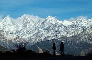
Tanakpur is a city and a municipal board in Champawat district of Uttarakhand state of India. Located in the plains area in the northern part of India. The town is the gateway for Purnagiri Temple as well as the 'Gateway to the Kumaon Himalayas'.
Sultanpur is a town in Udham Singh Nagar district in the Indian state of Uttarakhand. It is located approximately 15 kilometres from Kashipur and 42 kilometers from Rudrapur.

Joya is a nagar panchayat located along highway NH-24 in Amroha district in the Western Uttar Pradesh. It is predominantly a milk producing city. Joya was a gram panchayat before 1988. The late Abrar Hussain was the first chairman of Joya in 1988.

National Highway 30 is a primary national highway in India. NH 30 connects Sitarganj in Uttarakhand with Ibrahimpatnam, Vijayawada in Andhra Pradesh. The total length of this highway is 1,984.3 km (1,233.0 mi). It starts at the junction of NH 9 at Sitarganj and ends at the junction of NH 65 at Ibrahimpatnam, Vijayawada. Development of Ibrahimpatnam-Jagadalpur Route is under process. Rajdeep Rohan joint venture is the contract agency for this project. Second bridge is under construction at pilgrimage city of Bhadrachalam which is famous for temple of Lord Shri Rama. NH-30 runs through the states of Uttarakhand, Uttar Pradesh, Madhya Pradesh, Chhattisgarh, Telangana and Andhra Pradesh in India.
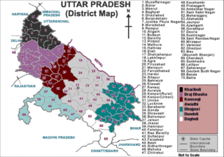
Western Uttar Pradesh is a region in India that comprises the western districts of Uttar Pradesh state, including the areas of Rohilkhand and those where Khariboli, Braj and Kannauji are spoken. The region has some demographic, economic and cultural patterns that are distinct from other parts of Uttar Pradesh, and more closely resemble those of Haryana and Rajasthan states. Western Uttar Pradesh has experienced rapid economic growth, in a fashion similar to Haryana and Punjab, due to the successes of the Green Revolution. A significant part of western Uttar Pradesh is a part of National Capital Region of India. The largest city of the region is Ghaziabad, while the second-largest city, Agra, is a major tourist destination.
Kolada (Kiratpur) is a village Post- Danpur in Rudrapur Mandal, Udham Singh Nagar district of Uttarakhand State, India.

National Highway 7 is a highway connecting Fazilka (Punjab) to Mana (Uttarakhand) in India. It passes through the Indian states of Punjab, Haryana, Himachal Pradesh, and Uttarakhand.
The Uttarakhand movement refers to the events of statehood activism within the undivided state of Uttar Pradesh which ultimately resulted in the formation of Uttarakhand, India as a separate state. Uttarakhand became a state on 9 November 2000. The formation of Uttarakhand was achieved after a long struggle and many sacrifices. The demand to make Uttarakhand a state was first raised at a special session of the Indian National Congress held in Srinagar on 5-6 May 1938. The demand gradually strengthened following a series of events. In 1994, the demand for a separate state eventually took the form of a mass movement that resulted in the formation of India's 27th state by 2000. Jeet Bahadur Gurung became the first martyr in Pauri on 8 August 1994.
National Highway 344 is a national highway in India running from Ambala in Haryana to Roorkee in Uttarakhand. It is a secondary route of National Highway 44. NH-344 runs in the states of Haryana, Punjab, Uttar Pradesh and Uttarakhand in India.

National Highway 309A, commonly referred to as NH 309A, is a single lane highway connecting the city of Rameshwar to Almora in the Indian State of Uttarakhand. Before the creation of Uttarakhand state in 2000, the Almora-Bageshwar stretch of this Highway was a part of the State Highway 37 of Uttar Pradesh, which ran from Bageshwar to Bareilly.
National Highway 709B, is a National Highway in India. The highway starts from Akshardham in Delhi. It is a spur road of National Highway 9. NH-709B traverses the states of Delhi and Uttar Pradesh passing through various towns and cities in Western Uttar Pradesh like Baghpat, Baraut, Ailum, Shamli, Thanabhawan, Rampur Maniharan, Saharanpur, Behat, Shakumbhari. Shamli acts as a major junction as two other major highways of the area (709A) and (709AD) intersect with (709B) at Shamli.
National Highway 709AD, commonly called Panipat-Khatima Highway is a national highway in India. It is a spur road of National Highway 9. NH-709AD traverses the states of Uttar Pradesh and Haryana passes through various Cities and Town in Haryana and Western Uttar Pradesh like Shamli, Muzaffarnagar, Bijnor in India before its terminal at Nagina in Bijnor. Shamli acts as one of the major junction as two other major highways of the area (709A) and (709B) intersects with (709AD) at Shamli. The other major junction is Muzaffarnagar where this highway intersects with (334) Delhi-Rishikesh National Highway and UP State Highway 59
National Highway 731K, commonly referred to as NH 731K is a national highway in India. It is a secondary route of National Highway 31. NH-731K runs in the states of Uttar Pradesh and Uttarakhand in India.