
Nagaland is a landlocked state in the north-eastern region of India. It is bordered by the Indian states of Arunachal Pradesh to the north, Assam to the west, Manipur to the south, and the Naga Self-Administered Zone of the Sagaing Region of Myanmar (Burma) to the east. Its capital city is Kohima and its largest city is the twin Chümoukedima–Dimapur. The state has an area of 16,579 square kilometres (6,401 sq mi) with a population of 1,980,602 as per the 2011 Census of India, making it one of the smallest states of India.

Northeast India, officially the North Eastern Region (NER), is the easternmost region of India representing both a geographic and political administrative division of the country. It comprises eight states—Arunachal Pradesh, Assam, Manipur, Meghalaya, Mizoram, Nagaland and Tripura, and the "brother" state of Sikkim.

Dimapur is the largest city and municipality in the Indian state of Nagaland. As of 2011, the municipality had a population of 122,834. The city is the main gateway and commercial centre of Nagaland. Located near the border with Assam along the banks of the Dhansiri River. Its main railway station is the second busiest station in Northeast India. The District of Dimapur is bifurcated into two other districts; namely, Chumoukedima and Niuland.

Mokokchung is a municipality in the Mokokchung District of the Indian state of Nagaland. It serves as the district headquarters as well as the main urban hub of Mokokchung District. Mokokchung is the cultural nerve centre of the Ao people and is economically and politically the most important urban centre in northern Nagaland. The town is made up of 16 wards of which Kumlong, Sangtemla, Alempang and Yimyu are the largest.

Chümoukedima, formerly spelled Chumukedima, is a municipality in the Chümoukedima District of the Indian state of Nagaland. It is situated on the left bank of the Chathe and with its surrounding area that includes several other towns and villages, the Chümoukedima Metropolitan Area is the largest urban agglomeration in Nagaland in terms of area and third largest in terms of population, after Dimapur and Kohima.
Amguri is a town and municipal area committee in Sivasagar district in the state of Assam, India.
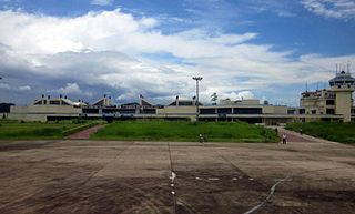
Dimapur Airport is a domestic airport serving Chümoukedima–Dimapur and its neighbouring areas. It is located between the districts of Chümoukedima and Dimapur, from where National Highway 29 passes just beside the airport. It is the only airport in the state of Nagaland. The terminal building can handle 500 departing and 300 arriving passengers, and was built during World War II. There are plans for expansion of the airport to meet international norms by acquiring land at Aoyimti Village.
The Ministry of Development of North Eastern Region is a Government of India ministry, established in September 2001, which functions as the nodal Department of the Central Government to deal with matters related to the socio-economic development of the eight States of Northeast India: Arunachal Pradesh, Assam, Manipur, Meghalaya, Mizoram, Nagaland, Tripura and Sikkim. It acts as a facilitator between the Central Ministries/ Departments and the State Governments of the North Eastern Region in the economic development including removal of infrastructural bottlenecks, provision of basic minimum services, creating an environment for private investment and to remove impediments to lasting peace and security in the North Eastern Region.

National Highway 61 is a National Highway of India. It runs from Kohima, the capital of the state of Nagaland and ends at Jhanji in the state of Assam. The highway is 240 km (150 mi) long, of which 220 km (140 mi) is in Nagaland and 20 km (12 mi) is in Assam.
Old NH-37 is now National Highway 127. It's a national highway of India. It connects Nagaon, New Gatanga and Jakhalabandha in the state of Assam.
East-West Industrial Corridor Highway of Arunachal Pradesh, a 2-lane and 966.78 km long including existing 274.20 km Pasighat-Manmao route, is a proposed highway across lower foothills of Arunachal Pradesh state in India from Bhairabkunda in Assam at tri-junction of Bhutan-Assam-Arunachal Pradesh in west to Kanubari tri-junction of Nagaland-Assam-Arunachal Pradesh in east.

National Highway 2 is a national highway in India that runs from Dibrugarh in Assam to Tuipang in Mizoram. This national highway passes through the Indian states of Assam, Nagaland, Manipur and Mizoram. This national highway is 1,325.6 km (823.7 mi) long. Before renumbering of national highways, NH-2 was variously numbered as old national highways 37, 61, 39, 150 and 54.
National Highway 29 is a primary national highway in India. This highway was previously part of old national highways 36, 39 and 150. Due to rationalisation of national highway numbers of India by Gazette notification on 5 March 2010, it was renumbered as National Highway 29. NH-29 runs across the Indian states of Assam, Nagaland and Manipur. This national highway is 338.5 km (210.3 mi) long.
National Highway 702, commonly called NH 702 is a national highway in states of Nagaland and Assam in India. It is an offshoot of primary National Highway 2.
National Highway 702A, commonly called NH 702A is a national highway in states of Nagaland and Manipur in India. It is a branch of primary National Highway 2.
National Highway 702B, commonly called NH 702B is a national highway of India. It is entirely located in the state of Nagaland in India. NH-702B is a branch of National Highway 702.
National Highway 702D, commonly called NH 702D is a national highway in states of Nagaland and Assam in India. It is an offshoot of primary National Highway 2. This new highway has been accorded national status to upgrade it to two lanes and provide better movement for defense personnel and goods movement.
National Highway 329A, commonly called 329A is a national highway in India. It is a spur road of National Highway 329. NH-329A traverses the states of Assam and Nagaland in India.
National Highway 129A, commonly referred to as NH 129A is a national highway in India. It is a spur road of National Highway 29. NH-129A traverses the states of Manipur and Nagaland in India.

Chümoukedima District is the 15th district of the Indian state of Nagaland. It was created on 18 December 2021. The district is bounded by Kohima District to the east, Peren District to the south, Tseminyü District & Niuland District to the north-east, Dimapur District to the north and Karbi Anglong District of Assam to the west and north-west. The district headquarter is located in the municipality of Chümoukedima.


