Central Railway is one of the 19 zones of Indian Railways. Its headquarters is in Mumbai at Chhatrapati Shivaji Maharaj Terminus. It has the distinction of operating the first passenger railway line in India, which opened from Mumbai to Thane on 16 April 1853.

Buldhana district is located in the Amravati division of Maharashtra, India. It is situated at the western border of Vidarbha region and is 500 km away from the state capital, Mumbai. The district has towns and cities like Shegaon, Malkapur, Khamgaon, Lonar and Chikhli. It is surrounded by Madhya Pradesh in the north, Akola, Washim, and Amravati districts on the east, Jalna district on the south, and Jalgaon and Aurangabad districts on the west. Khamgaon is the largest city in the district.
Shegaon is a city and municipal council in the Buldhana district in the Indian state of Maharashtra. Shegaon has become a pilgrimage centre due to the influence of Shri Sant Gajanan Maharaj, who is considered a saint by Hindus.
Buldhana is a City and a Municipal Council in the Indian state of Maharashtra. Established on 17 February 1893. It is the Administrative headquarters of the Buldhana District of Amravati division. It is the Second largest City in the district after Khamgaon and a popular place as a hill station because the city is surrounded by the mountainous area in the Ajanta range. Buldhana is around 552 km away from the state capital Mumbai. Buldhana has many religious, historical and tourist places around it like Balaji Temple in rajur ghat a replica of popular Balaji Temple of South India, is a famous religious and tourist place within city limits, Shri Gajanan Maharaj Temple in Shegaon around 75 km away, the World Famous Lonar Crater a National Geo-heritage monument created by meteorite impact is almost 100 km from city of Buldhana, Rajmata Jijau birthplace Sindkhed Raja is 90 km, Sailani Baba Dargah a major attraction of Buldhana just 25 km away from the city, The World Heritage Site Ajanta Caves is just 55 km away from the City and Dnyanganga Wildlife Sanctuary in Botha Forest is also just 20 km away from the city and many more tourist places are there around Buldhana City.
Chikhli is a city and a municipal council in Buldana district in Vidarbha Region of Maharashtra state, India. It is located on the Pune-Nagpur highway. It is situated at the westernmost border of Vidarbha region of Maharashtra and is 500 km from the state capital, Mumbai. Chikhli is situated on the border of the Marathwada Region and Vidarbha Regions of Maharashtra.
Erandol is a town and a taluka in Jalgaon district in the Indian state of Maharashtra state. It is situated on the banks of the Anjani River.
Nandura (नांदुरा) is a city in Buldhana district in Maharashtra state. Nandura is the headquarters of Nandura taluka. Nandura is situated on the National Highway No. 6 and the Mumbai-Howrah railway line. The municipality of Nandura was established during the British Raj in 1931. The place is major supplier of milk products to all nearby area.
Songadh is a taluka in Tapi district in the Indian state of Gujarat.
Parola is a city and a municipal council in Jalgaon district in the Indian state of Maharashtra. It is located on the Hajira (Surat)–Dhule–Kolkata national highway 6. The municipal council was established by the British government before the independence of India. This City is centuries old known for the two main features such as the Shree Balaji Temple and The Parola fort Also known as the native of Rani Laxmibai of Jhansi.
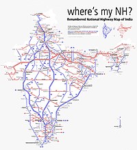
National Highway 6 & Economic Corridor 1 (EC1), was a National Highway in India that has been separately designated under the new national highway numbering system. It was officially listed as running over 1,949 km (1,211 mi) from Surat to Kolkata. The route was also known as Asian Highway 46 (AH46) & Mumbai - Kolkata Highway and Great Eastern Highway.
Asian Highway 46 (AH46) is a route of the Asian Highway Network within India, from Kharagpur in West Bengal to Dhule in Maharashtra. The route is part of old National Highway 6.

Bhusawal railway division is one of the five railway divisions of the Central Railway (India) zone of Indian Railways, located at Bhusawal in the Jalgaon district of Maharashtra state in western India. The other railway divisions are: Mumbai CSMT, Nagpur, Solapur and Pune. There are 115 railway stations in the Bhusawal railway division.
Kusumba is a small village in the state of Maharashtra, India. It is located in the Dhule taluka of Dhule District in Maharashtra at dhule- sakri road on Gujarat-Nagpur highway.
The 22827/22828 Puri–Surat Express is a Superfast train running between Puri of Odisha and Surat of Gujarat.
'Sagbara is a Town in Sagbara Taluka in Narmada District of Gujarat State, India. It is located 55 KM towards South from District head quarters Rajpipla. It is a Taluka head quarter.. Its location is at NH-753B Ankleshwar-Valia-Netrang-Dediapada-Sagbara up to State Border to Akkalkuva in Maharashtra
The 13425 / 13426 Surat–Malda Town Express is an Express train running between Surat of Gujarat and Malda Town of West Bengal.

The Nagpur–Bhusawal section is part of the Howrah–Nagpur–Mumbai line and connects Nagpur and Bhusawal both in the Indian state of Maharashtra. This section also has a number of branch lines. Part of one of the major trunk lines in the country, Nagpur–Bhusawal section passes through a section of the Deccan Plateau. The main line crosses Nagpur, Wardha, Amravati, Akola, and Buldhana districts of Vidarbha region and Jalgaon district of Khandesh region.

The 12809/10 Howrah Junction–Mumbai Chhatrapati Shivaji Maharaj Terminus Mail is a Mail train belonging to Indian Railways - South Eastern Railways that runs between Howrah Junction and Mumbai CSMT in India.

National Highway 161,, is a National Highway in India running through the states of Maharashtra and Telangana of India. The National Highway 161 joins the cities of Akola, Washim, Hingoli, Nanded, Degloor, Bichkunda, Pitlam, Nizampet, Shankarampet(A), Jogipet, Sanga Reddy.
National Highway 161A, commonly as NH 161A, is a National Highway running through states of Karnataka and Maharashtra, with a total length 507 Kilometres that connects Akot, Maharashtra to Bidar, Karnataka. National Highway 161A joins the cities of Akot, Akola, Barshitakli, Mangrulpir, Manora, Digras, Arni, Mahur, Kinwat, Himayatnagar, Mudkhed, Waghala, Mukhed, Maharashtra–Karnataka border in central southern India with each other. It is an auxiliary route of National Highway 61.