Several possible origins for the name Purnia have been proposed. The name may originate from the Sanskrit word Purna–Aranya, which means "complete jungle".[3]Purnia could also be an altered form of the old name Purania, derived from the word purain or Lotus, which is said to have grown on the Kosi and Mahananda rivers.
Purnia is part of the Mithila region.[4] Mithila first gained prominence after being settled by Indo-Aryan peoples who established the Mithila Kingdom (also called Kingdom of the Videhas).[5] During the late Vedic period (c. 1100–500 BCE), Videha became one of the major political and cultural centers of South Asia, along with Kuru and Pañcāla. The kings of the Videha Kingdom were called Janakas.[6] The Videha Kingdom was later incorporated into the Vajjika League, which had its capital in the city of Vaishali, which is also in Mithila.[7]
In the 17th century, the rulers of Purnia were involved in wars with the Kings of Limbuwan.
At the beginning of British rule, many people from Europe came to Purnia and settled here. At that time, Purnia was a complete 'Purania', meaning jungle. In the early days of colonization, Europeans settled around the Saura river in the middle of the city, now known as Rambagh area. Later, Europeans started coming west from the Saura river and making their own 'Kothi'. The civil lines existing throughout India, were also in Purnia.
Among the most active European zamindars in Purnia were Alexander John Forbes and Palmer. Alexander John Forbes bought the Sultanpur pargana from Mahajan Babu Pratap Singh of Murshidabad in 1859 and became a Zamindar. Forbes city (Forbesganj) in the Sultanpur pargana was named after him, but Forbes lived in the city of Purnia. Forbes built the race course and various other clubs. Alexander Forbes and his wife Diana died of malaria in 1890. The Forbes family sold the Sultanpur estate to the country's business house J. K. Singhania, because of the ongiong jute cultivation.
Another Englishman who lived in Purnia was Palmer. He bought the zamindari of a king and settled in Purnia. Palmer's only daughter, Mrs. Downing, was his heir. Mrs. Downing had two heirs - her son C. Y. Downing and daughter Mrs. Hays. Today, the grand residence of Hez Saheb is the main building of Purnia College. There is a dyke in Purnia, which protects the city from floods. In Baghmara, one area in the frontier of the city, there is an embankment parallel to the Saura river, which was built by Palmer. This dam was named the Palmer Dam.
Indigo cultivation was first started in Purnia by an Englishman named John Kelly. Later, many Europeans cultivated indigo here vigorously. Shillingford, a hunter, was the foremost among them who built 'Nilha Kothi' in places such as Nilganj, Mahendrapur, and Bhavbada. Neelha farmers, another group of English farmers, heavily contrubuted to Purnia's settlement. Purnia was a very green and open area.[8]
Geography
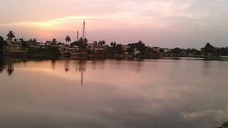
Purnia and its surrounding lands lie in the sub-montane alluvial tract of the Gangetic Plain. The city however lies on the banks of numerous tributaries of the Koshi River. Two major rivers traverse Purnia city with the Kari Kosi river on the western end and the Saura river on the eastern end. The main city is situated between these two rivers.
Purnia city has an area of 92 square kilometres (36sqmi).
Climate
Purnia is known for its favourable climate; it has earned the name "Mini Darjeeling" for this reason. Purnia has a largely humid climate, with the highest level of rainfall in Bihar state and humidity rising to above 70%. A cold season, from November to February, is followed by a hot season from March to June. The monsoon season begins in early June and lasts until September; 82% of its total annual rainfall falls during the monsoon season.
January, the coldest month, has a mean daily minimum temperature of 5 to 10°C and a mean daily maximum of 20 to 25°C. Wind is typically light in the non-monsoon seasons but during the monsoon, storms and depressions originating in the Bay of Bengal cause heavy rain and strong winds.
Climate data for Purnia (1981–2010, extremes 1901–2009)
As of the 2011 census, Purnia Municipal Corporation had a total population of 282,248, of which 148,077 were males and 134,171 were females.[11] It had a sex ratio of 906 females to 1,000 males. The population below 6 years was 43,050. The literacy rate for the 6+ population was 73.02%, compared to the 74.04% national average.[12] Purnia Urban Agglomeration, comprising Purnia Municipal Corporation and Kasba (Nagar Panchayat),[13] had a population of 310,817 in 2011.[14]
Maithili,[15] is native language and Hindi, Urdu and Bengali are the other languages spoken by the people of Purnia. Surjapuri and Santali dialects are also spoken in some parts of the city. English continues to be taught in the English Medium schools.
Economy
In recent years, Purnia is growing as epicenter for service, automobile and many more economic sectors. This results as fast changing in lifestyle and economy of city. Primarily, Gulabbagh, Khuskibagh, Line Bazar, Bhatta Bazar, Madhubani Bazar, City Industrial Estate and Maranga Outgrowth Centre are the prime locations for the economic activities.
Gulabbagh and Khuskibagh
Gulabbagh and Khuskibagh are situated at eastern outskirts of main city, and known for their famous agriculture market (in local language mandi). Many merchants come from Nepal and West Bengal to purchase supplies of raw material and specially Maize. GulabBagh in Purnia houses a major grain storehouse and is Asia's largest maize trading center. This location as well as central and eastern Bihar supply the grain requirements of Bengal, Nepal, and the states of Northeast India. It is also an epic centre of highways in Purnia, as well NH 27, NH 231, NH 131A passes that provides excellent connectivity to all parts of India. Khuskibagh has fruit and vegetable market that is too close to Purnia Junction (station code: PRNA) that provides rail connectivity.
Purnia is a powerful poultry producer and has also been catering to the demands of the nearby regions of Nepal and West Bengal for many years. Purnia is also well known for its fisheries. Fishes are also transported to the nearby markets of West Bengal, especially those in the Siliguri Metropolitan Region, the nearest large urban centre.
Education
BMT Law College, Purnea
Purnia has always been a centre of education in the north Bihar region. Zila School, founded in 1800 during the period of British rule, is Purnia's oldest school, and one of the city's largest. Jawahar Navodaya Vidyalaya, Garhbanaili (14km away from the main city) is a prestigious school run by the government. Vidya Vihar Residential School, the leading Boarding School of Bihar has its campus at Parora on Purnea. India's leading school chain G D Goenka Public School has its third campus of Bihar in Purnea after Patna and Gaya. Purnia also has a Kendriya Vidyalaya. Other prominent schools are -
Simanchal Institute of Medical Science, Kasba (OPD functional from Jan 2018)
Government Medical College and Hospital, Sadar Hospital Purnea
Shershah Institute of Medical Sciences
Medical College and Hospital by Millia Educational Trust
3D animation and multimedia institute:
Animation School (Madhubani Bazar)
The Indian Red Cross Society has the largest blood bank in the state after Patna, with a capacity of 1,000 units. The Bihar government recently inaugurated one of the three megastock warehouses for drugs/medicines at Kasba, which aims to serve the 13 districts of North Bihar.
The region has Purnea University (9th University of Bihar). The university is the only one in Purnea Commissionerate. It includes colleges of Purnea, Katihar, Araria and Kishanganj.
Transportation
Air
Helicopter at Air Force Station Purnea
Purnea Airport, also known as Chunapur Airport (Airforce Station), is located within the cantonment area but is restricted to army usage only. Proposals for the airport to operate scheduled flights are being widely discussed at the level of the state government.
NH-231 at Purnea College of Engineering NH-131A Purnea-Manihari Highway
National Highways namely NH 31, NH 27, NH 231, NH 131A make Purnia accessible to the people from nearby cities & states while state highways connect the other neighbouring cities and villages to the main city area. The newly constructed NH 27 directly connects Purnia to some important towns and cities of North Bihar namely Darbhanga & Muzaffarpur. It takes nearly 5 hours to reach Muzaffarpur through this Expressway. This expressway which also traverses through the newly built Kosi Mahasetu bridge ends at Muzaffarpur to continue further for Patna. It has turned out to be an alternate route for Patna & has helped in decongesting the ever busy and traffic-prone NH31.
The east–west corridor connecting Silchar, Assam to Gujarat passes through Purnia in the form of NH 27. It is a modern four-lane highway constructed by National Highways Authority of India (NHAI). State Highways 60, 62, 65, 77 & 90 also pass through Purnia.
NH 31 and NH 27 are four-lane expressways and are a strength to the intercity transportation services.
Notable events
Phanishwar Nath Renu's popular story "Maare Gaye Gulfam" which was adapted into a film Teesri Kasam (The Third Vow), by Basu Bhattacharya (produced by the poet-lyricist Shailendra) in 1966 was shot in Purnia, in which old Purnea is pictured, especially 'the Gulabbag Mela'.[citation needed]
Purnia held the record for making and displaying the world's longest tricolour flag, with the length measured at 7,100 metres (7.1km) before it was broken on 12 August 2019 by Raipur, Chattisgadh.[17][18][19]
Araria is a city and a municipality that is the headquarters of Araria district in the Indian state of Bihar. Araria is situated in the northern part of Bihar.
Katihar is a city situated in the eastern part of the state of Bihar in India. It is the regional headquarters of Katihar district. It is one of the important cities of Bihar. It is also a main stop on the Barauni–Guwahati line.
Munger, formerly spelt as Monghyr, is a twin city and a Municipal Corporation situated in the Indian state of Bihar. It is the administrative headquarters of Munger district and Munger Division. Munger was one of the major cities in Eastern India and undivided Bengal during Mughal period and British Raj. It is one of the major political, cultural, educational and commercial center of Bihar and Eastern India. Munger is situated about 180km from east of capital city Patna, about 480km west of Eastern India's largest city Kolkata and 1200km from country's capital New Delhi.
Madhepura is a municipality in Madhepura district in the Indian state of Bihar. It stands at the centre of Kosi ravine, It was called Madhyapura- a place centrally situated which was subsequently transformed as Madhipura into present Madhepura. It is surrounded by Araria and Supaul districts in the north, Khagaria and Bhagalpur districts in the south, Purnia district in the east and Saharsa district in the West.
Saharsa is a city and municipal corporation in the Saharsa District in the eastern part of the state of Bihar, India. It is situated near the eastern banks of the Kosi River. It serves as the administrative headquarters for Saharsa District and is also the Divisional headquarters of the Kosi Division.
Supaul is a town and a municipality that is headquarters of Supaul district in the Indian state of Bihar. Supaul is the administrative headquarters of this district. There Are 11 block under the Supaul district Supaul, Kishanpur, Saraigarh-Bhaptiyahi, Pipra, Triveniganj, Raghopur, chhatapur, Nirmali, Marauna, Basantpur and pratapganj.
The East Central Railway is one of the 19 railway zones in India. It is headquartered at Hajipur and comprises Sonpur, Samastipur, Danapur, Pt. Deen Dayal Upadhyaya, and Dhanbad divisions.
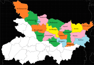
Araria district is one of the thirty-eight districts of Bihar state, India. Araria district is a part of Purnia division. The district occupies an area of 2,830 km2 (1,090 sq mi). Araria town is the administrative headquarters of this district. Distance from Nepal border is only about 8 km from Forbesganj head quarter.
Purnia District is one of the thirty-eight districts of the Indian state of Bihar. The city of Purnia is the administrative headquarters of this district. The city of Purnia has continued its tradition of hoisting the national flag at 12:07 am on every Independence Day since 1947. Purnia district is a part of Purnia Division. The district extends northwards from the Ganges river.
Katihar district is one of the thirty-eight districts of Bihar state in India, and Katihar city is the administrative headquarters of this district. The district is a part of Purnia Division. It is prominently known for its Katihar Junction Railway Station, which is a Category A station on the Barauni–Guwahati line. It has been included in the Aspirational Districts Program of the Government of India since 2018, to improve its socio-economic indicators.
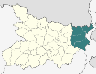
Purnia division is an administrative geographical unit of Bihar state of India. Purnia is the administrative headquarters of the division. The division consists of Purnia district, Katihar district, Araria district, and Kishanganj district. It was established in 1990. It is also known as Seemanchal. It is a part of the Kosi—Seemanchal subregion of the cultural Mithila region.
Dalsinghsarai is a city and Municipal Council in the Samastipur District of Bihar, India. It is also one of the subdivisions and blocks of Bihar. It is situated on the bank of the river Balan.
Forbesganj is a city with municipality in the Araria District in the state of Bihar, India, situated at the border of Nepal.
Nirmali is a town and a notified area in Supaul district in the Indian state of Bihar.
Kasba is a satellite town of Purnia city and part of Purnia Urban Agglomeration in Purnia district in the Indian state of Mithila region of Bihar.
Korha is a town and tehsil (sub-district) in the Katihar district, Bihar state, India. The name is sometimes spelled Kora.
Banmankhi is a block in Purnia district of Bihar state, India.
North Bihar is a term used for the region of Bihar, India, which lies north of the Ganga river.
Kolasi is a village situated near Katihar Town (5.0 km) of Bihar state in India. It is located on the banks of the Kosi river, surrounded by temples and agriculture lands and gathering a harmonized society above cast and religion. Generally, this village is known for having a common market place for nearby villages people and for its peaceful environment.
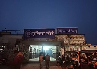
Purnia Court railway station,, is a railway station serving the city of Purnea in Bihar. This station is managed by the East Central Railway under the Samastipur railway division. Earlier it was a MG line which has now been converted to standard BG line and lies on the Purnea–Banmankhi–Saharsa section. The BG line was inaugurated by the Railway Minister of India Suresh Prabhu on 10 June 2016.
↑ Jha, Makhan (1997). Anthropology of Ancient Hindu Kingdoms: A Study in Civilizational Perspective. pp.27–30. ISBN9788175330344.
↑ Witzel, Michael (1989). Caillat (ed.). Tracing the Vedic dialects in Dialectes dans les litteratures Indo-Aryennes. Paris. pp.13, 17 116–124, 141–143.{{cite book}}: CS1 maint: location missing publisher (link)
↑ Witzel, Michael (1989). "Tracing the Vedic dialects". In Caillat, C. (ed.). Dialectes dans les litteratures Indo-Aryennes. Paris: Fondation Hugot. pp.141–143.
↑ Hemchandra, R. (1972). Political History of Ancient India. Calcutta: University of Calcutta.
This page is based on this Wikipedia article Text is available under the CC BY-SA 4.0 license; additional terms may apply. Images, videos and audio are available under their respective licenses.