
The Godavari is India's second longest river after the Ganga river and drains into the third largest basin in India, covering about 10% of India's total geographical area. Its source is in Trimbakeshwar, Nashik, Maharashtra. It flows east for 1,465 kilometres (910 mi), draining the states of Maharashtra (48.6%), Telangana (18.8%), Andhra Pradesh (4.5%), Chhattisgarh (10.9%) and Odisha (5.7%). The river ultimately empties into the Bay of Bengal through an extensive network of tributaries. Measuring up to 312,812 km2 (120,777 sq mi), it forms one of the largest river basins in the Indian subcontinent, with only the Ganga and Indus rivers having a larger drainage basin. In terms of length, catchment area and discharge, the Godavari is the largest in peninsular India, and had been dubbed as the Dakshina Ganga.

The Eastern Ghats are a discontinuous range of mountains along India's eastern coast. The Eastern Ghats pass through Odisha, Andhra Pradesh to Tamil Nadu in the south passing some parts of Karnataka as well as Telangana. They are eroded and cut through by four major rivers of peninsular India, viz., Mahanadi, Godavari, Krishna, and Kaveri. Deomali with 1672 m height is the tallest point in Odisha. Arma Konda/Jindhagada Peak with 1680 m is the highest point in Andhra Pradesh. BR hill range located in Karnataka is the tallest hill range in Eastern Ghats with many peaks above 1750 m height. Kattahi Betta in BR hills with the height of 1822 m is the tallest peak in Eastern Ghats. Thalamalai hill range in Tamil Nadu is the second tallest hill range. Araku range is the third tallest hill range.Edakkal Caves in Wayanad district is present in between Western Ghats and Eastern Ghats and is connecting Wayanad plateau and Nilgiri plateau.

The Bhagirathi Hooghly River or the 'Bhāgirathi-Hooghly', or simply just Ganga, called the Kati-Ganga in the Puranas, is a river that rises close to Giria, which is north of Baharampur and Palashi, in Murshidabad and is the western distributary of the Ganges. The main course of the Ganges then flows into Bangladesh as the Padma. A man-made canal at Farakka connects the Ganges to the Bhagirathi to bring the abundant waters of the Himalayan river to the comparatively narrow river that rises in West Bengal.

Srikalahasti Temple is located in the town of Srikalahasti, in Tirupati district in the state of Andhra Pradesh, India. It is one of the most famous Shiva temples in South India, and is said to be the site where Kannappa was ready to offer both his eyes to cover blood flowing from the linga before Shiva stopped him and granted him moksha.
The South Pennar River is a river in India. Bangalore, Hosur, Tiruvannamalai, and Cuddalore are the important cities on the banks of South Pennar river. This is the second longest river in Tamil Nadu, with a length of 497 km, after the Kaveri. Chandapura, Anekal, Hosur, Bagalur and Chengam are the major industrial settlements on its banks. The river is severely polluted by industrial waste as it flows through major industrial areas in the eastern suburbs of Bangalore, Industrial parks of Hosur and Chengam.

Palar is a river of southern India. It rises in the Nandi Hills in Chikkaballapura district of Karnataka state, and flows 93 kilometres (58 mi) in Karnataka, 33 kilometres (21 mi) in Andhra Pradesh and 222 kilometres (138 mi) in Tamil Nadu before reaching its confluence into the Bay of Bengal at Vayalur about 75 kilometres (47 mi) south of Chennai. It flows as an underground river for a long distance only to emerge near Bethamangala town, from where, gathering water and speed, it flows eastward down the Deccan Plateau. The Towns of Bethamangala, Santhipuram, Kuppam, Ramanaickenpet, Vaniyambadi, Ambur, Melpatti, Gudiyatham, Pallikonda, Anpoondi, Melmonavoor, Vellore, Katpadi, Melvisharam, Arcot, Ranipet, Walajapet, Kanchipuram, Walajabad, Chengalpattu, Kalpakkam, and Lattur are located on the banks of the Palar River. Of the seven tributaries, the chief tributary is the Cheyyar River.

Karamana is a river flowing through the city of Thiruvananthapuram in Kerala, India. The river starts near the southern tip of the Western Ghats(Sahyadri Mountains) at Agastyar Koodam. The river flows 66 km westward and merges with the Arabian Sea at Panathura near Kovalam. The river gets its name from Karamana, a suburb of Thiruvananthapuram city, through which it flows.

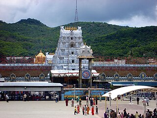
Tirupati is a city in the Indian state of Andhra Pradesh. It is the administrative headquarters of the Tirupati district. The city is home to the important Hindu shrine of Tirumala Venkateshwara Temple and other historic temples It is located at a distance of 150 km from Chennai, 250 km from Bangalore. It is one of the eight Svayam vyakta kshetras dedicated to Vishnu. Tirupati is a municipal corporation and the headquarters of Tirupati (urban) mandal, Tirupati (rural) mandal, and the Tirupati revenue division.

Chittoor district is one of the eight districts in the Rayalaseema region of the Indian state of Andhra Pradesh. It has a population of 18,72,951 according to 2011 census of India. It is a major market centre for mangoes, grains, sugarcane, and peanuts. The district headquarters is located at Chittoor.
Gandikota is a village and historical fort on the right bank of the Penna river, 15 km from Jammalamadugu in Kadapa district, Andhra Pradesh, India. The fort was the centre of power for various dynasties, such as the Kalyani Chalukyas, Pemmasani Nayakas, and the Golconda Sultanate. A sand fort was constructed by Kaka Raja, Vassals of Kalyani Chalukya rulers. Various additions of Islamic architecture were made during subsequent Muslim rule.
Srikalahasti is a holy town in Tirupati district of the Indian state of Andhra Pradesh. It is a municipality and the revenue division of Srikalahasti mandal and Srikalahasti revenue division. It is a part of the Tirupati Urban Development Authority, which is located on the banks of the River Swarnamukhi.
Kosasthalaiyar River, also known as Kortalaiyar, is one of the three rivers that flow in the Chennai metropolitan area.
Arani, also known as Araniar or Araniyar, is a 108 km long river in India. It flows through the states of Tamil Nadu and Andhra Pradesh.
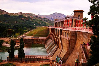
The Kalyani Dam is a gravity dam constructed across the Swarnamukhi river at Tirupati city and located in Tirupati District of Andhra Pradesh, India. This dam is one of the major sources of water supply for Tirupati city and its catchment areas. Once filled, the dam can cater to the water needs of Tirupati for at least two years.

Chemuru is a village in Thottambedu mandal, located in Tirupati district of Indian state of Andhra Pradesh. This belongs to Chiyyavaram Gram panchayat, Srikalahasti assembly constituency and Tirupati parliamentary constituency
Vykuntapuram Barrage is an Indian barrage and water storage project. It is under construction on Krishna River 23 kilometers upstream of existing Prakasam Barrage with FRL 25M. It is designed to store 10 TMC of flood water coming from the Vyra and Munneru rivers. The backwater of this dam will extend beyond Pokkunuru to the toe of Pulichintala dam. Andhra Pradesh Chief Minister Nara chandrababu Naidu laid the foundation stone for this project on 13 February 2019.
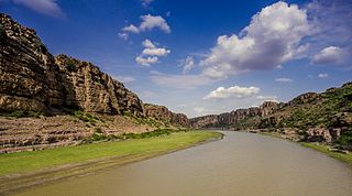
Tirupati district is one of the eight districts of Rayalaseema region in the Indian state of Andhra Pradesh. The district headquarters is located at Tirupati city. This district is known for its numerous historic temples, including the Hindu shrine of Tirumala Venkateswara Temple and Sri Kalahasteeswara temple. The district is also home to Satish Dhawan Space Centre, a rocket launch centre located in Sriharikota. The river Swarnamukhi flows through Tirupati, Srikalahasti and joins the Bay of Bengal.