Pakala, Tirupati district

Last updated

Pakala
Pakala Railway Station.JPG
Pakala railway station view from foot overbridge
India Andhra Pradesh location map (current).svg
Red pog.svg
Pakala
Location in Andhra Pradesh, India
India location map.svg
Red pog.svg
Pakala
Pakala (India)
Coordinates: 13°28′00″N79°07′00″E / 13.4667°N 79.1167°E / 13.4667; 79.1167
CountryIndia
State Andhra Pradesh
District Tirupati
Mandal Pakala
Elevation
361 m (1,184 ft)
Population
  Total28,556
Languages
  Official Telugu
Time zone UTC+5:30 (IST)
Telephone code918585
Vehicle registration AP03 (Before 2019) / AP39 (2019)
Nearest city Tirupati
Sex ratio2:1 /
Lok Sabha constituency Tirupati
Vidhan Sabha constituencyChandragiri

Pakala is a town in Tirupati district of the Indian state of Andhra Pradesh. It is the mandal headquarters of Pakala mandal. [1] It comes under Tirupati revenue division.

Contents

About

Pakala is a mandal in Tirupati district of Andhra Pradesh, India. Pakala Mandal Headquarters is Pakala town. It belongs to Rayalaseema region. It is located 44 km towards West from District headquarters Tirupathi. 450 km from State capital Amaravathi .

Pakala Mandal is bounded by Puthalapattu Mandal towards South, Penumuru Mandal towards South, Pulicherla H/O Reddivaripalle Mandal towards North, Irala Mandal towards west. Chittoor and Tirupati are the nearby cities to Pakala.

Pakala consists of 180 villages and 28 panchayats. Nagamma Agraharam is the smallest village and Pakala is the biggest village. It is in the 371 m elevation (altitude).

Chittoor, Tirupati (Tirumala), Vellore, Tirutani, Srikalahasti ,Kanipakam are the nearby important tourist destinations to see.

Education

The primary and secondary school education is imparted by government, aided and private schools, under the School Education Department of the state.[2][3] The medium of instruction followed by different schools are English, Telugu and Urdu.

Colleges

Schools

Demographics

Telugu is the official and widely spoken language. Also people speak Urdu, Tamil. Total population of Pakala Mandal is 56,802 living in 13,533 houses, Spread across total 180 villages and 28 panchayats. Males are 28,414 and females are 28,388

Geography

Pakala is located at 13°28′00″N79°07′00″E / 13.4667°N 79.1167°E / 13.4667; 79.1167 . [2] It has an average elevation of 361 meters (1184 feet).

Distance

Governance

Pakala(Chandragiri) is one of the 175 assembly constituencies of Andhra Pradesh Legislative Assembly, India. pakala is part of Chittoor (Lok Sabha constituency). N. Reddeppa of YSR Congress Party is the sitting Member of Parliament for Chittoor (Lok Sabha constituency) and Chevireddy Bhaskar Reddy of YSR Congress Party is Chandragiri the sitting Member of Legislative Assembly for Chandragiri (Assembly constituency).

Politics

Pakala is an Assembly constituency in Andhra Pradesh and the constituency number is 285.

Entertainment

There are two theaters in pakala town, Ramakrishna Theatre, Srinivas & Mini Theatre

Transport

Roadways

Pakala is well connected to major cities through national and state highways. The National Highways through Pakala Town are, National Highway 40 (India) connecting Pileru, Madanapalli, Kadapa, Kurnool and Hyderabad on North and connecting Chittoor, Vellore and Chennai on South National Highway 69 (India) connecting Chittoor with Kolar and Bangalore on West National Highway 140 (India) connecting Chittoor with Tirupati and Nellore on East. The city has total road length of 382.30 km. [3]

Public transport

The Andhra Pradesh State Road Transport Corporation operates bus services from Chittoor bus station. [4] Bus services are operated to Chittoor, Tirupati,Pileru, Madanapalli, Palamaner, Srikalahasti, Nellore, and also to all other major Panchayth and Villages in the Pakala, Chittoor District, Chittoor District, Andhra Pradesh.

Railways Pakala Junction railway station is a major railway station in Pakala Town of Andhra Pradesh. It lies on Gudur–Katpadi branch line section and is administered under Guntakal railway division of South Coastal Railway zone. Nearest major railway station is Tirupati, Andhra Pradesh, 45 km from Pakala Town. Katpadi Junction railway station, Tamil Nadu, is 70 km from Pakala Town.

Airports

The nearest domestic airport is Tirupati Airport at Renigunta in Tirupati of Tirupati district, Andhra Pradesh.

The nearest international airports are Chennai International Airport at Chennai and Kempegowda International Airport at Bangalore.

Climate

Climate data for Chittoor, Andhra Pradesh
MonthJanFebMarAprMayJunJulAugSepOctNovDecYear
Mean daily maximum °C (°F)28.7
(83.7)
31.4
(88.5)
34.4
(93.9)
36.4
(97.5)
40.0
(104.0)
35.5
(95.9)
33.5
(92.3)
33.3
(91.9)
32.8
(91.0)
31.1
(88.0)
28.8
(83.8)
27.6
(81.7)
32.8
(91.0)
Mean daily minimum °C (°F)17.7
(63.9)
18.8
(65.8)
21.2
(70.2)
24.5
(76.1)
26.2
(79.2)
25.7
(78.3)
24.6
(76.3)
24.4
(75.9)
23.8
(74.8)
22.5
(72.5)
20.2
(68.4)
18.1
(64.6)
22.3
(72.2)
Average rainfall mm (inches)6
(0.2)
6
(0.2)
8
(0.3)
24
(0.9)
58
(2.3)
72
(2.8)
102
(4.0)
115
(4.5)
145
(5.7)
162
(6.4)
110
(4.3)
54
(2.1)
862
(33.7)
Source: Climate-Data.org [5]

Villages Under Pakala Mandal

List of all towns and Villages in Pakala Mandal of Tirupati district, Andhra Pradesh. Complete details of Population, Religion, Literacy and Sex Ratio in tabular format. us 2011

Home Andhra Pradesh District List Tirupati District Pakala Mandal

List of all towns and Villages in Pakala Mandal of Tirupati district, Andhra Pradesh. Complete details of Population, Religion, Literacy and Sex Ratio in tabular format.

Landmarks

The Swayambu Varasidhi Vinayakaswamy temple at Kanipakam is the famous notable Hindu temple near the city.

The 11th century historical Chandragiri Fort is the notable landmark near the city.

From Pakala Town we have NARL National Atmosphere and Research Laboratory towards Tirupati 5 km from town

Related Research Articles

<span class="mw-page-title-main">Chittoor</span> City in Andhra Pradesh, India

Chittoor is a city and district headquarters in Chittoor district of the Indian state of Andhra Pradesh. It is also the mandal and divisional headquarters of Chittoor mandal and Chittoor revenue division respectively. The city has a population of 153,756 and that of the agglomeration is 175,647.

<span class="mw-page-title-main">Madanapalle</span> City in Andhra Pradesh, India

Madanapalle is the largest city in Annamayya district and Rajampet Lok Sabha constituency of the Indian state of Andhra Pradesh. It is a Selection Grade Municipal City Council. Madanapalle is headquarters of Madanapalle Mandal,Madanapalle revenue division and PKM Urban Development Authority.

<span class="mw-page-title-main">Tirupati</span> City in Andhra Pradesh, India

Tirupati is a city in the Indian state of Andhra Pradesh. It is the administrative headquarters of the Tirupati district. The city is home to the important Hindu shrine of Tirumala Venkateshwara Temple and other historic temples. It is located at a distance of 150 km from Chennai, 250 km from Bangalore, 406 km from Amaravati. It is one of the eight Svayam vyakta kshetras dedicated to Vishnu. Tirupati is a municipal corporation and the headquarters of Tirupati (urban) mandal, Tirupati (rural) mandal, and the Tirupati revenue division.

<span class="mw-page-title-main">Chittoor district</span> District of Andhra Pradesh, India

Chittoor district is one of the eight districts in the Rayalaseema region of the Indian state of Andhra Pradesh. It had a population of 18,72,951 at the 2011 census of India. It is a major market centre for mangoes, grains, sugarcane, and peanuts. The district headquarters is at Chittoor City.

Kadiri is a major city in Sri Sathya Sai District the Indian state of Andhra Pradesh. It is a Special Grade Municipal City Council and headquarters of Kadiri Mandal and Kadiri Revenue Division. Kadiri Taluka ('Tehsil') was the largest taluk in the state of Andhra Pradesh when there was taluka system in Andhra Pradesh Kadiri is known for its jasmine and saffron flowers. Kadiri saffron is widely sold in Andhra and Karnataka. The Sri Lakshmi Narasimhaswamy Temple is reminiscent of Kadiri to the people of Karnataka, Telangana And Tamil Nadu. The name of Kadiri has also some interesting past. The habitation was initially named as Khadripuram as ‘khadara’ plants were largely found in the surrounding forests and Khadri has later transformed as Kadiri.

<span class="mw-page-title-main">Srikalahasti</span> Town in Andhra Pradesh, India

Srikalahasti is a town in Tirupati district located in the Indian state of Andhra Pradesh. It is a municipality and the revenue division of Srikalahasti mandal and Srikalahasti revenue division. It is a part of the Tirupati Urban Development Authority, which is located on the banks of the River Swarnamukhi.

<span class="mw-page-title-main">Railway Koduru</span> Town in Andhra Pradesh, India

Railway Koduru is a town in Annamayya district of the Indian state of Andhra Pradesh, located in the Rayalaseema Region.

<span class="mw-page-title-main">Pileru</span> Town in Andhra Pradesh, India

Pileru is a census town in Annamayya district of Rayalaseema region of the Indian state of Andhra Pradesh. Pileru is located 197 Km North East of Bangalore, The Capital City Of Karnataka and 189 Km North West of Chennai, The Capital City Of Tamil Nadu and 464 Km South To The State Capital Amaravati .It is the mandal headquarters of Pileru mandal in Rayachoti revenue division. The name 'Pileru' means a "small river stream" or "Pilla Eru" in Telugu.

Tirupati Rural mandal is one of the 34 mandals in Tirupati district of Andhra Pradesh in India. It is under the administration of Tirupati revenue division and the headquarters are located at Tirupati.

<span class="mw-page-title-main">Tirupati railway station</span> Railway station in Andhra Pradesh, India

Tirupati Main railway station is a railway station located in the Indian state of Andhra Pradesh. It serves Tirupati and experiences a regular flow of tourists visiting the Tirumala Venkateswara Temple in the Tirupati district. It is an environmentally friendly station, and has been awarded a Gold rating by the Indian Green Building Council. There are several railway stations that fall within the city limits of Tirupati, namely Tiruchanur, Renigunta Junction, Tirupati West Halt, and Chandragiri railway station.

Elavur is a village in the Tiruvallur district of Tamil Nadu, India. It is located in the Gummidipoondi taluk border between Tamil Nadu and Andhra pradesh. NH16 Chennai-Kolkata Highway. India's First modern Integrated Check post opened by Tamil Nadu chief minister and also located frontline medical village. ELR is and railway station code for Elavur.Farming land can be found in this place.

Chandragiri mandal is one of the 34 mandals in Tirupati district of the Indian state of Andhra Pradesh. It is under the administration of Tirupati revenue division and the headquarters are located at Chandragiri.

Srikalahasti mandal is one of the 34 mandals in Tirupati district of the Indian state of Andhra Pradesh. It is under the administration of Srikalahasti revenue division and the headquarters are located at Srikalahasti. The mandal is bounded by Renigunta, Yerpedu, Narayanavanam and Thottambedu.

<span class="mw-page-title-main">Chemuru</span> Village in Andhra Pradesh, India

Chemuru is a village in Thottambedu mandal, located in Tirupati district of Indian state of Andhra Pradesh. This belongs to Chiyyavaram Gram panchayat, Srikalahasti assembly constituency and Tirupati parliamentary constituency

<span class="mw-page-title-main">Gudur–Katpadi section</span> Railway line in India

Gudur–Katpadi branch line connects Gudur of Andhra Pradesh town with Katpadi of Tamil Nadu City. This entire line is under the jurisdiction of Guntakal railway division. It is an electrified railway section

<span class="mw-page-title-main">Nadimpalli, Chittoor</span> Village in Andhra Pradesh, India

Nadimpalli is a remote rural village in Puthalapattu mandal of Chittoor district in Andhra Pradesh in India.

<span class="mw-page-title-main">Tirupati district</span> District in Andhra Pradesh, India

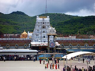
Tirupati district is one of the eight districts of Rayalaseema region in the Indian state of Andhra Pradesh. The district headquarters is located at Tirupati city. This district is known for its numerous historic temples, including the Hindu shrine of Tirumala Venkateswara Temple and Sri Kalahasteeswara temple. The district is also home to Satish Dhawan Space Centre, a rocket launch centre located in Sriharikota. The river Swarnamukhi flows through Tirupati, Srikalahasti, Naidupeta, Vakadu and join into the Bay of Bengal.

<span class="mw-page-title-main">Annamayya district</span> District of Andhra Pradesh, India

Annamayya district is one of the eight districts in the Rayalaseema region of Andhra Pradesh, established in 2022. Rayachoti is the district administrative headquarters, and Madanapalle is the most populated city in the district.

Pakala mandal is one of the 34 mandals in Tirupati district of the Indian state of Andhra Pradesh. It is under the administration of Tirupati revenue division and the headquarters are located at Pakala.

References

  1. "Chittoor District Mandals" (PDF). Census of India. pp. 472, 514. Retrieved 19 June 2015.
  2. "Maps, Weather, and Airports for Pakala, India". fallingrain.com.
  3. "DETAILS OF ROADS IN EACH ULB OF ANDHRA PRADESH". Archived from the original on 1 August 2016.
  4. "Bus Stations in Districts". Andhra Pradesh State Road Transport Corporation. Archived from the original on 22 March 2016. Retrieved 9 March 2016.
  5. "CLIMATE: CHITTOOR" . Retrieved 19 February 2016.