
The Godavari is India's second longest river after the Ganga River and drains the third largest basin in India, covering about 10% of India's total geographical area. Its source is in Trimbakeshwar, Nashik, Maharashtra. It flows east for 1,465 kilometres (910 mi), draining the states of Maharashtra (48.6%), Telangana (18.8%), Andhra Pradesh (4.5%), Chhattisgarh (10.9%) and Odisha (5.7%). The river ultimately empties into the Bay of Bengal through an extensive network of distributaries. Its 312,812 km2 (120,777 sq mi) drainage basin is one of the largest in the Indian subcontinent, with only the Ganga and Indus rivers having a larger drainage basin. In terms of length, catchment area and discharge, the Godavari is the largest in peninsular India, and had been dubbed as the Dakshina Ganga.

Palar is a river of southern India. It rises in the Nandi Hills in Chikkaballapura district of Karnataka state, and flows 93 kilometres (58 mi) in Karnataka, 33 kilometres (21 mi) in Andhra Pradesh and 222 kilometres (138 mi) in Tamil Nadu before reaching its confluence into the Bay of Bengal at Vayalur about 75 kilometres (47 mi) south of Chennai. It flows as an underground river for a long distance only to emerge near Bethamangala town, from where, gathering water and speed, it flows eastward down the Deccan Plateau. The Towns of Bethamangala, Santhipuram, Kuppam, Mottur, Ramanaickenpet, Vaniyambadi, Ambur, Melpatti, Gudiyatham, Pallikonda, Anpoondi, Melmonavoor, Vellore, Katpadi, Melvisharam, Arcot, Ranipet, Walajapet, Kanchipuram, Walajabad, Chengalpattu, Kalpakkam, and Lattur are located on the banks of the Palar River. Of the seven tributaries, the chief tributary is the Cheyyar River.

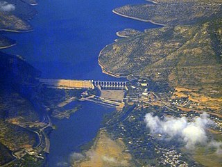
The Dowleswaram Barrage was an irrigation structure originally built in 1852 on the lower stretch of the Godavari River before it empties into the Bay of Bengal. It was rebuilt in 1970 when it was officially renamed as Sir Arthur Cotton Barrage or Godavari Barrage.
The Jalaput Dam is a hydroelectric dam built on the Machkund River, a tributary of the Godavari River in India which rises in the Mudugal hills of Alluri Sitharama Raju district and near Ondra Gadda it becomes the boundary between the states of Andhra Pradesh and Odisha. This dam is the most ignored one in India, and currently it is in dilapidated condition.

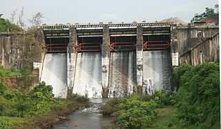
Nizam Sagar Dam is an Indian dam named after the Nizam of Hyderabad. It is a reservoir constructed across the Manjira River, a tributary of the Godavari River, between Achampet and BanjePally villages of the Kamareddy district in Telangana, India. It is located at about 144 km (89 mi) north-west of Hyderabad. Nizam Sagar is the oldest dam in the state of Telangana.

The River Nagavali also known as Langulya is one of the main rivers of Southern Odisha and Andhra States in India, between Rushikulya and Godavari basins.

The Gosthani river is a river in India. It rises in the Ananthagiri Hills of the Eastern Ghats and flows through the Borra Caves which lie near its source. It is the largest river flowing through Visakhapatnam city. It flows for 120 km before joining the Bay of Bengal through an estuary near Bheemunipatnam. The river basin drains the two coastal districts of Vizianagaram and Visakhapatnam. The basin exhibits a subdendritic and dendritic pattern of drainage. The Gosthani's is a minor river basin with a total drainage area of less than 2000 km2. Much of the basin is covered by khondalite group of gneissic rocks. About 3% of the total area of the Visakhapatnam district is under the Gosthani basin. The river is rainfed, receiving an average rainfall of 110 cm most of which comes from the south-west monsoon. There are several red sand hills near Bheemunipatnam, where the Gosthani joins the Bay of Bengal, which are reminiscent of the Chambal ravines. These are thought to have been formed six millennia ago due to shifts in the river's course following tectonic activity. The river joins the Bay of Bengal at Bhimli where it forms an estuary.

River Champavathi is a small river which originates in the Eastern Ghats at an altitude of 1,200 metres above mean sea level near Andra village and flows eastwards and joins the Bay of Bengal near the village Konada. The river passes through Gajapathinagaram, Nellimarla, Saripalli, Denkada, Palem and Natavalasa of Vizianagaram district. The river has four main tributaries Eduvampula Gedda, Chitta Gedda, Pothula Gedda and Gadi Gedda. The basin has a drainage area of 1,410 square kilometres. This area is divisible into Hilly terrain, Vizianagaram plains and Coastal plains.

River Vamsadhara or River Banshadhara is an important east-flowing river between Rushikulya and Godavari, in Odisha and Andhra Pradesh states in India.

The Gundlakamma River is a seasonal waterway that flows through the east-central part of the state of Andhra Pradesh, India. It arises in the Nallamala Hills, an offshoot of the Eastern Ghats. Gundlakamma is the largest of all the rivers that originate from the Nallamalla Hills.

The Polavaram Project is an under construction multi-purpose irrigation project on the Godavari River in the Eluru District and East Godavari District in Andhra Pradesh. The project has been accorded National project status by the Central Government of India. Its reservoir back water spreads up to the Dummugudem Anicut and approx 115 km on Sabari River side. Thus back water spreads into parts of Chhattisgarh and Odisha States. It gives major boost to tourism sector in Godavari Districts as the reservoir covers the famous Papikonda National Park, Polavaram hydro electric project (HEP) and National Waterway 4 are under construction on left side of the river. It is located 40 km to the upstream of Sir Arthur Cotton Barrage in Rajamahendravaram City and 25 km from Rajahmundry Airport.

The Bhadra Dam or Lakkavalli Dam, which has created the Bhadra Reservoir, is located on the Bhadra River a tributary of Tungabhadra River. Bhadra Dam is located in Chikmagalur district on the border of Bhadravathi and Tarikere, in the western part of Karnataka in India. The benefits derived from the reservoir storage are irrigation with gross irrigation potential of 162,818 hectares, hydro power generation of 39.2 MW, drinking water supply and industrial use. The dam commissioned in 1965 is a composite earth cum masonry structure of 59.13 metres (194.0 ft) height with length of 1,708 metres (5,604 ft) at the crest level, which submerges a land area of 11,250.88 hectares.
Mahatma Gandhi Kalwakurthy Lift Irrigation Scheme (MGKLIS) is a lift irrigation project on River Krishna located in Mahbubnagar district in the Indian state of Telangana. The lift canal starts from the backwaters of Srisailam Dam near Kollapur. The gravity driven, 100 kilometer-long canal provides cultivation for nearly 137,000 hectares (340,000 acres)in 300 villages located in constituencies of Kollapur, Wanaparthy, Nagarkurnool, Kalwakurthy, Jadcherla, and Achampet.
Kosasthalaiyar River is one of the three rivers that flow in the Chennai metropolitan area, the other two being the Cooum and the Adyar.
Lower Manair Dam also known as LMD was constructed across the Manair River, at Alugunur village, Thimmapur mandal, Karimnagar District, in the Indian state of Telangana during 1974 to 1985. It provides irrigation to a gross command area of 163,000 hectares.
The "Somasila Dam" is a dam constructed across the Penna River near Somasila, Nellore district, Andhra Pradesh, India. The reservoir impounded by the dam has a surface area of 212.28 km2 with live storage capacity of 1.994 km3 (1,616,562 acre⋅ft) or 75 tmcft.
Yerrakaluvaa is a river that forms boundary between Khammam district of Telangana and West Godavari district of Andhra Pradesh.

Meghadri Gedda Reservoir, officially "Sri Dronam Raju Satyanarayana Reservoir Scheme" is a reservoir and dam in Visakhapatnam, India. It is one of the main water sources of the Visakhapatnam city. Its capacity is 11 MGD and it is maintained by Greater Visakhapatnam Municipal Corporation.

Sri Varada Narayana Murty Raiwada Reservoir Project or Raiwada Reservoir is a reservoir constructed across the Sarada River near Raiwada village, Devarapalli mandal, Anakapalli district, 58 km from Visakhapatnam city. It is one of the main water sources for Visakhapatnam city. Its capacity is 2,360 tcm, and it is maintained by Irrigation & CAD Dept.
Peruvannamuzhi dam, also known as Kuttiady (Id) Dam, is a dam built on the Kuttiady River at Peruvannamuzhi in Chakkittapara Grama Panchayath in Kozhikode district, Kerala. It is 16 km away from Kuttiady town and it is 55 km from Kozhikode town. It was constructed as part of the Kuttiady irrigation project. The project consists of a masonry dam across Kuttiyady River and 13 earth dams to maximize the storage of the reservoir. The construction of this project started in 1962 and was commissioned in 1973.
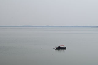
 Sunset on river Sarada near Anakapalli in Visakhapatnam District
 Sarada river joining the Bay of Bengal


