
Sathyamangalam is a town and municipality in Erode district in the Indian state of Tamil Nadu. It lies on the banks of the Bhavani river, a tributary of the Cauvery in the foothills of the Western Ghats and is the headquarters of Sathyamangalam taluk. It is about 65 km from Erode, 58 km from Tiruppur and 65 km from Coimbatore. As of 2011, the town had a population of 37,816.

The South Deccan Plateau dry deciduous forests is a tropical dry forest ecoregion in southern India. The ecoregion lies in the southernmost portion of the Deccan Plateau, and includes the southernmost portion of the Eastern Ghats.

Dharmapuri is a city in the north western part of Tamil Nadu, India. It serves as the administrative headquarters of Dharmapuri district which is the first district created in Tamil Nadu after the independence of India by splitting it from then Salem district on 2 October 1965. The city is located 50 km from Krishnagiri, 69 km from Salem, 60 km from Tirupattur, 90 km from Hosur, 117 km from Thiruvannamalai, 126 km from Bangalore and Erode, 181 km from Tiruppur, 200 km from Coimbatore and Tiruchirappalli, 300 km from Madurai and the state capital Chennai. It is located between latitudes N 11 47’ and 12 33’ and longitudes E 77 02’ and 78 40’. It is one of the major leading cultivators and producers of mangoes in the state along with Krishnagiri, and is often referred as Mango Capital of India.
The Cardamom Hills or Yela Mala are mountain range of southern India and part of the southern Western Ghats located in Idukki district, Kerala, India. Their name comes from the cardamom spice grown in much of the hills' cool elevation, which also supports pepper and coffee. The Western Ghats and Periyar Sub-Cluster including the Cardamom Hills are UNESCO World Heritage Sites.

The Palani Hills are a mountain range in the southern Indian states of Tamil Nadu and Kerala. The Palani Hills are an eastward extension of the Western Ghats ranges, which run parallel to the west coast of India. The Palani Hills adjoin with the high Anamalai range on the west and extend east into the plains of Tamil Nadu, covering an area of 2,068 square kilometres (798 sq mi). The highest part of the range is in the southwest, and reaches 1,800-2,500 metres elevation; the eastern extension of the range is made up of hills 1,000-1,500 m (3,281-4,921 ft) high.
Anaimalai Tiger Reserve, earlier known as Indira Gandhi Wildlife Sanctuary and National Park and as Anaimalai Wildlife Sanctuary, is a protected area in the Anaimalai Hills of Pollachi and Valparai taluks of Coimbatore District and Udumalaipettai taluk in Tiruppur District, Tamil Nadu, India. The Tamil Nadu Environment and Forests Department by a notification dated 27 June 2007, declared an extent of 958.59 km2 that encompassed the erstwhile IGWLS&NP or Anaimalai Wildlife Sanctuary, as Anaimalai Tiger Reserve under the Wildlife Protection Act, 1972. According to the National Tiger Conservation Authority, the Reserve presently includes a core area of 958.59 km2 and buffer/peripheral area of 521.28 km2 forming a total area of 1479.87 km2.

Krishnagiri district is one of the 38 districts of the state of Tamil Nadu, in India. This district is carved out from Dharmapuri District by 2004. The municipal town of Krishnagiri is the district headquarters. In Tamil Nadu, e-Governance was first introduced at Krishnagiri district under the National e-Governance Project (NEGP) in revenue and social welfare departments on a pilot basis. The district is one of the largest producers of mangoes in India. As of 2011, the district had a population of 1,879,809 with a sex-ratio of 958 females for every 1,000 males. Hosur is the most populous town in the district.

Dharmapuri is one of the 38 districts in the state of Tamil-Nadu, India. It is the first district created in Tamil Nadu after the independence of India by splitting it from then-Salem district on 2 October 1965. Dharmapuri District is one of the major producers of mango in the state, fine quality granite is found in the district. It is also one of the main sericulture belts in the state. Around 30 percent of the district's area is under forest cover. Kaveri enters Tamil Nadu through this district. Dharmapuri district had the lowest literacy rate of 74.23% in Tamilnadu during the 2011 census.
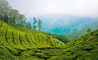
Meghamalai, commonly known as the High Wavy Mountains, is a mountain range located in the Western Ghats in the Theni district near Kumily, Tamil Nadu. It is dotted with cardamom plantations and tea plantations. The mountain range is 1,500 metres above sea level, and it is rich in flora and fauna. The area, now mostly planted with tea plants, includes cloudlands, high wavys, venniar, and the manalar estates belonging to the Woodbriar Group. Access is largely restricted and includes largely untouched remnants of evergreen forest.

Chinnar Wildlife Sanctuary is located 18 km north of Marayoor on State Highway 17 in the Marayoor and Kanthalloor panchayats of Devikulam taluk in the Idukki district of India's Kerala state. It is one of 18 wildlife sanctuaries among the protected areas of Kerala.
Palacode taluk is a taluk in the Dharmapuri district of the Indian state of Tamil Nadu. The headquarters of the taluk is the town of Palacode. Part of Cauvery North Wildlife Sanctuary is located in this taluk.
Karian Shola National Park is a protected area in the Western Ghats, India, nominated as a national park in 1989. The Western Ghats are a chain of mountains running down the west of India parallel with the coast some 30 to 50 km inland. They are not true mountains, but the edge of a fault that resulted about 150 million years ago as the subcontinent of India split from Gondwanaland. They are older than the Himalayan mountain range and are clothed in ancient forests. They influence the weather in India as they intercept the incoming monsoon storm systems. The greatest rainfall occurs between June and September during the southwest monsoon, with lesser amounts falling in the northeast monsoon between October and November. The Western Ghats are a UNESCO World Heritage Site and are considered to be one of the eight most important "hotspots" of biological diversity in the world.

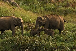
The Melagiris are a range of hills on the Eastern Ghats, bound by the river Cauvery on the west. Melagiri contain an expanse of 1295 km2 of dry deciduous and semi-evergreen forests. It is an elephant country and contains two traditional elephant corridors. With the Bannerghatta National Park in the North east and Cauvery Wildlife Sanctuary in the south, the forest range stretches to sanctuaries of BR Hills and Sathyamangala and joins the tiger reserves of Nilgiri Biosphere. As the meeting point of the Western Ghats and Eastern Ghats, these forests form a vital link in the elephant corridors of South India, connecting the Bannerghatta National Park and the River Cauvery. It borders some of the prominent tiger sanctuaries of the south.

Sathyamangalam Tiger Reserve is a protected area and tiger reserve located along the area straddling both the Western Ghats and Eastern Ghats in the Erode District of the Indian state of Tamil Nadu. The Sathyamangalam Forest Division is part of the Bramhagiri-Nilgiris-Eastern Ghats Elephant Reserve notified in 2003. In 2008, part of the Sathyamangalam Forest Division was declared a wildlife sanctuary and enlarged in 2011, it covers a forest area of 1,411.6 km2 (545.0 sq mi). It is the largest wildlife sanctuary in Tamil Nadu. In 2013, an area of 1,408.6 km2 (543.9 sq mi) of the erstwhile sanctuary was notified as a tiger reserve. It was the fourth tiger reserve established in Tamil Nadu as a part of Project Tiger and is the third largest in the state.

Sigur Plateau is a plateau in the north and east of Nilgiri District in the Nilgiri Hills of Tamil Nadu, South India. It covers the 778.8 square kilometres (300.7 sq mi) portion of the Moyar River drainage basin on the northern slopes of the Nilgiri Hills, south of the Moyar River.
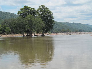
The Cauvery Wildlife Sanctuary is a protected area located in the Mandya, Chamarajanagar and Ramanagar districts of Karnataka, India. The Cauvery River passes through its midst. An area of 510.52 km2 (197.11 sq mi) was established as Cauvery Wildlife Sanctuary on 14 January 1987 under Section 18 of the Wildlife Protection Act 1972 with the objective of providing protection, conservation and development of Wildlife and its environment. The sanctuary was expanded to its current area of 102,753 hectares in 2013. On its east, it adjoins Dharmapuri forest division of Tamil Nadu state.

The Department of Environment and Forests is one of the departments of Government of Tamil Nadu. The department was created in 1995 and is responsible for environmental management and forests in the state.

Malai Mahadeshwara Wildlife Sanctuary or Male Mahadeshwara Wildlife Sanctuary is a protected Wildlife sanctuary in the Western Ghats and is located in the state of Karnataka in India. It is named after the presiding deity "Lord Male Mahadeshwara" of the famed Male Mahadeshwara Hills Temple located within the sanctuary. The sanctuary lies in the Chamarajanagar district of Karnataka. It is at a distance of 140 km (87 mi) from Mysuru and 210 km (130 mi) from Bengaluru.
Thanthai Periyar Wildlife Sanctuary is a proposed protected area located along the area straddling both the Western Ghats and Eastern Ghats in the Erode District of the Indian state of Tamil Nadu. It was notified by Government of Tamil Nadu in March 2023 and will become the 18th wildlife sanctuary in Tamil Nadu. It will cover a forest area of 801.15 km2 (309.33 sq mi) and will cover parts of Gobichettipalayam and Anthiyur taluks in Erode district in Western Tamil Nadu.