Related Research Articles
The Western Ghats or the Western Mountain range is a mountain range that covers an area of 160,000 km2 (62,000 sq mi) in a stretch of 1,600 km (990 mi) parallel to the western coast of the Indian peninsula, traversing the states of Gujarat, Maharashtra, Goa, Karnataka, Kerala and Tamil Nadu. It is a UNESCO World Heritage Site and is one of the eight biodiversity hotspots in the world. It is sometimes called the Great Escarpment of India. It contains a very large proportion of the country's flora and fauna, many of which are endemic to this region. According to UNESCO, the Western Ghats are older than the Himalayas. They influence Indian monsoon weather patterns by intercepting the rain-laden monsoon winds that sweep in from the south-west during late summer. The range runs north to south along the western edge of the Deccan Plateau and separates the plateau from a narrow coastal plain called Konkan along the Arabian Sea. A total of 39 areas in the Western Ghats, including national parks, wildlife sanctuaries and reserve forests, were designated as world heritage sites in 2012 – twenty in Kerala, ten in Karnataka, six in Tamil Nadu and four in Maharashtra.
The Cardamom Hills or Yela Mala are mountain range of southern India and part of the southern Western Ghats located in Idukki district, Kerala, India. Their name comes from the cardamom spice grown in much of the hills' cool elevation, which also supports pepper and coffee. The Western Ghats and Periyar Sub-Cluster including the Cardamom Hills are UNESCO World Heritage Sites.

The Palani Hills are a mountain range in the southern Indian states of Kerala and Tamil Nadu. The Palani Hills are an eastward extension of the Western Ghats ranges, which run parallel to the west coast of India. The Palani Hills adjoin the high Anamalai range (Kerala) on the west, and extend east into the plains of Tamil Nadu, covering an area of 2,068 square kilometres (798 sq mi). The highest part of the range is in the southwest, and reaches 1,800-2,500 metres elevation; the eastern extension of the range is made up of hills 1,000-1,500 m (3,281-4,921 ft) high.

Periyar, IPA: [peɾijɐːr], is the longest river and the river with the largest discharge potential in the Indian state of Kerala. It is one of the few perennial rivers in the region and provides drinking water for several major towns. The Periyar is of utmost significance to the economy of Kerala. It generates a significant proportion of Kerala's electrical power via the Idukki Dam and flows along a region of industrial and commercial activity. The river also provides water for irrigation and domestic use throughout its course besides supporting a rich fishery. Due to these reasons, the river has been named the "Lifeline of Kerala". Kochi city, in the vicinity of the river mouth draws its water supply from Aluva, an upstream site sufficiently free of seawater intrusion. Twenty five percent of Kerala's industries are along the banks of river Periyar. These are mostly crowded within a stretch of 5 kilometres (3 mi) in the Eloor-Edayar region (Udhyogamandal), about 10 kilometres (6 mi) north of Kochi harbor.

The Anamala or Anaimalai, also known as the Elephant Mountains, are a range of mountains in the southern Western Ghats of central Kerala and span the border of western Tamil Nadu in Southern India. The name anamala is derived from the Malayalam word aana and the Tamil word aanai, meaning elephant, or from tribal languages. Mala or Malai means 'hill', and thus 'Elephant hill'.

Kanyakumari district is one of the 38 districts in Tamil Nadu state and the southernmost district in mainland India. It stands second in terms of population density among the districts of Tamil Nadu. It is also the richest district in Tamil Nadu in terms of per capita income, and also tops the state in Human Development Index (HDI), literacy, and education. The district's headquarters is Nagercoil.

Koonthankulam Bird Sanctuary or Kunthankulam is a 1.2933 km2 (0.4993 sq mi) protected area declared as a sanctuary in 1994. It adjoins the tiny village of Koonthankulam in Nanguneri Taluk of Tirunelveli district, Tamil Nadu, India. It is just 38 km away from Tirunelveli. 8.58102°N 77.76123°E It is composed of Koonthankulam and Kadankulam irrigation tanks, conveniently linked by tar road. This is the largest reserve for breeding water birds in South India. It is an Important Bird Area, code: IN269, criteria: A1, A4i.

Periyar National Park and Wildlife Sanctuary (PNP) is a protected area located in the districts of Idukki and Pathanamthitta in Kerala, India. It is notable as an elephant reserve and a tiger reserve. The protected area encompasses 925 km2 (357 sq mi), of which 305 km2 (118 sq mi) of the core zone was declared as the Periyar National Park in 1982. The park is a repository of rare, endemic, and endangered flora and fauna and forms the major watershed of two important rivers of Kerala: the Periyar and the Pamba.
The Palani Hills Wildlife Sanctuary and National Park is a proposed protected area in Dindigul District, Tamil Nadu India. The park will be an upgrade and expansion of the 736.87 km2(PRO) Palani (Kodaikanal) Wildlife Sanctuary which was to be established in 2008. The park includes about 36% of the 2,068 square kilometres (798 sq mi) in the Palani Hills. The park is located between latitude 10°7' - 10°28' N and longitude 77°16' - 77°46' E. Central location is 1.5 kilometres (0.93 mi) east northeast of Silver Cascade Waterfall and 4 kilometres (2.5 mi) E X NE of Kodaikanal Lake.
Meghamalai, commonly known as the High Wavy Mountains, is a mountain range located in the Western Ghats in the Theni district near Kumily, Tamil Nadu. It is dotted with cardamom plantations and tea plantations. The mountain range is 1,500 metres above sea level, and it is rich in flora and fauna. The area, now mostly planted with tea plants, includes cloudlands, high wavys, venniar, and the manalar estates belonging to the Woodbriar Group. Access is largely restricted and includes largely untouched remnants of evergreen forest.

Kalakkad Mundanthurai Tiger Reserve (KMTR) located in the South Western Ghats montane rain forests in Tirunelveli district and Kanyakumari district in the South Indian state of Tamil Nadu, is the second-largest protected area in Tamil Nadu. It is part of the Agasthyamala Biosphere Reserve.
The Agasthyamala Biosphere Reserve is a biosphere reserve in India established in 2001, located in the southernmost end of the Western Ghats and includes 3,500.36 km2 (1,351.50 sq mi) of which 1828 km2 is in Kerala and 1672.36 km2 is in Tamil Nadu. It encompasses the following wildlife sanctuaries: Shendurney Wildlife Sanctuary, Peppara Wildlife Sanctuary, Neyyar Wildlife Sanctuary, and Kalakkad Mundanthurai Tiger Reserve.

Agastyaarkoodam is a 1,868-metre (6,129 ft)-one of the peak in the Western Ghats, Tirunelveli District of Tamil Nadu, India. This peak is a part of the Agasthyamala Biosphere Reserve which lies on the border between the Indian states of Tamil Nadu, Tirunelveli district and Kerala, Thiruvananthapuram district. The perennial Thamirabarani River originates from the eastern side of the range and flows into the Tirunelveli district of Tamil Nadu.

Chinnar Wildlife Sanctuary is located 18 km north of Marayoor on State Highway 17 in the Marayoor and Kanthalloor panchayats of Devikulam taluk in the Idukki district of Kerala state in South India. It is one of 18 wildlife sanctuaries among the protected areas of Kerala.

The Grizzled Squirrel Wildlife Sanctuary (GSWS), also known as Srivilliputhur Wildlife Sanctuary, was established in 1988 to protect the Near threatened grizzled giant squirrel. Occupying an area of 485.2 km2, it is bordered on the southwest by the Periyar Tiger Reserve and is one of the best preserved forests south of the Palghat Gap.
Kerala State Highway 17, also called the Northern outlet road and Munnar - Udumalpet road, is notable for passing between the Anaimalai Hills and the Palani Hills, through or near three important protected areas and providing opportunities for viewing wildlife in unspoiled forests.
The total road length is about 59.1 km (36.7 mi).

The Pothigai Hills, also known as Agasthiyar Mountain is a 1,866-metre (6,122 ft)-tall peak in the southern part of the Western Ghats of South India. The peak lies in Tirunelveli District of Tamil Nadu near the border of Kerala.
Aintharuviar River is a river flowing in the Tirunelveli district of the Indian state of Tamil Nadu.
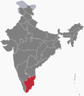
The following outline is provided as an overview of and topical guide to Tamil Nadu:
References
- 1 2 3 "TNFOREST :: Tamil Nadu Forest Department". Forests.tn.gov.in. Retrieved 2022-04-30.
- 1 2 "Nellai WLS". PeakVisor. Retrieved 2022-02-11.
- ↑ "Protected Area Gazette Notification Database (Tamil Nadu)". www.wiienvis.nic.in. Retrieved 2022-02-11.
- ↑ https://www.forests.tn.gov.in/tnforest/app/webroot/img/document/WILDLIFE-CONSERVATIONA-AND-MANAGEMENT-IN-TAMILNADU.pdf [ bare URL PDF ]
Coordinates: 9°06′N77°16′E / 9.100°N 77.267°E
| | This Tirunelveli district location article is a stub. You can help Wikipedia by expanding it. |
| | This article about protected areas of India is a stub. You can help Wikipedia by expanding it. |