
The Krishna River in the Deccan plateau is the third-longest river in India, after the Ganga and Godavari. It is also the fourth-largest in terms of water inflows and river basin area in India, after the Ganges, Indus and Godavari. The river, also called Krishnaveni, is 1,400 kilometres (870 mi) long and its length in Maharashtra is 282 kilometres. It is a major source of irrigation in the Indian states of Maharashtra, Karnataka, Telangana and Andhra Pradesh.

Kolleru Lake is one of the largest freshwater lakes in India and forms the largest shallow freshwater lake in Asia. 15 kilometers away from Eluru and 65 km from Rajamahendravaram, the lake is located between the Krishna and Godavari river deltas. Kolleru Lake is located in the Eluru district in the state of Andhra Pradesh. The lake is fed directly by water from the seasonal Budameru and Tammileru rivulets, and is connected to the Krishna and Godavari irrigation systems by over 67 major and minor irrigation canals. This lake is a major tourist attraction. Many birds migrate here in winter, such as Siberian crane, ibis, and painted storks. The lake was an important habitat for an estimated 20 million resident and migratory birds, including the grey or spot-billed pelican. The lake was declared as a wildlife sanctuary in November 1999 under India's Wildlife Protection Act of 1972, and designated a wetland of international importance in November 2002 under the international Ramsar Convention. The wildlife sanctuary covers an area of 308 km2.

The Tungabhadra River starts and flows through the state of Karnataka, India, during most of its course, then through Andhra Pradesh, and ultimately joins the Krishna River near Murvakonda in Andhra Pradesh.

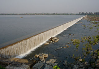
The Dowleswaram Barrage was an irrigation structure originally built in 1852 on the lower stretch of the Godavari River before it empties into the Bay of Bengal. It was rebuilt in 1970 when it was officially renamed as Sir Arthur Cotton Barrage or Godavari Barrage.

Nagarjuna Sagar Dam is a masonry dam across the Krishna River at Nagarjuna Sagar which straddles the border between Palnadu district in Andhra Pradesh and Nalgonda district in Telangana. The dam provides irrigation water to the districts of Krishna, Guntur, Palnadu, Prakasam and parts of West Godavari districts of Andhra Pradesh and also Nalgonda, Suryapet, Khammam, Bhadradri Kothagudem districts of Telangana. It is also a source of electricity generation for the national grid.
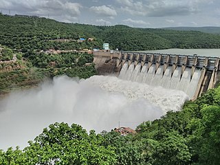
The Srisailam Dam is constructed across the Krishna River in Nandyal district, Andhra Pradesh and Nagarkurnool district, Telangana near Srisailam temple town and is the 2nd largest capacity working hydroelectric station in India.

River Vamsadhara or River Banshadhara is an important east flowing river between Rushikulya and Godavari, in Odisha and Andhra Pradesh states in India.
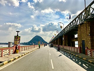
The Prakasam Barrage stretches 1223.5 m across the Krishna River connecting Vijayawada and Guntur districts in Andhra Pradesh, India. The barrage serves also as a road bridge and spans over a lake. The three canals associated with the barrage run through the city of Vijayawada, crossing it and giving it a Venetian appearance.

The Polavaram Project is an under construction multi-purpose irrigation project on the Godavari River in the Eluru District and East Godavari District in Andhra Pradesh. The project has been accorded National project status by the Central Government of India. Its reservoir back water spreads up to the Dummugudem Anicut and approx 115 km on Sabari River side. Thus back water spreads into parts of Chhattisgarh and Odisha States. It gives major boost to tourism sector in Godavari Districts as the reservoir covers the famous Papikonda National Park, Polavaram hydro electric project (HEP) and National Waterway 4 are under construction on left side of the river. It is located 40 km to the upstream of Sir Arthur Cotton Barrage in Rajamahendravaram City and 25 km from Rajahmundry Airport.
The Pranahita Chevella Lift Irrigation Project is a lift irrigation project to harness the water of Pranahita tributary of Godavari River for use in the Telangana state of India. The river water diversion barrage across the Pranahita River is located at Thammidihatti village in Komaram Bheem district of Telangana. This lift canal is an inter river basin transfer link by feeding Godavari River water to Krishna River basin. The chief ministers of Telangana and Maharashtra states reached an agreement in 2016 to limit the full reservoir level (FRL) of the barrage at 148 m msl with 1.85 tmcft storage capacity. In the year 2016, this project is divided into two parts. The scheme with diversion canal from the Thammmidihatti barrage to connect to existing Yellampalli reservoir across the Godavari River is presently called Pranahita barrage lift irrigation project. This scheme is confined to providing irrigation facility to nearly 2,00,000 acres in Adilabad district using 44 tmcft water.

The Pulichintala Project is a multi-purpose water management project for irrigation, hydropower generation, and flood control in the state of Andhra Pradesh, India, named after the prominent civil engineer, Kanuri Lakshmana Rao. It is a crucial irrigation facility for farmers in four coastal districts: West Godavari, Krishna, Guntur, Palanadu, and Prakasam, covering over 13 lakh acres. It has 24 gates and a balancing reservoir with a capacity of 46 Tmcft at 175 feet (53 m) MSL full reservoir level (FRL).
Rajiv Dummugudem Lift Irrigation Scheme is a lift irrigation scheme under execution which are located near Dummugudem, Khammam district in Telangana, India. There are three lift irrigation schemes by names Rajiv Dummugudem lift irrigation scheme, Indirasagar Rudrammakota Dummugudem lift irrigation scheme and Dummugudem to Sagar tail pond canal project. Rajiv Dummugudem lift irrigation scheme starting at 17°54′05″N80°52′45″E is planned to supply irrigation water for 200,000 acres in Khammam and Warangal districts drawing Godavari River water from the Dummugudem pond. Indira Dummugudem lift irrigation scheme starting at 17°33′49″N81°14′49″E is planned to supply irrigation water for 200,000 acres in Khammam, Krishna and West Godavari districts drawing Godavari River water from the back waters of Polavaram reservoir.
"Rajaolibanda Diversion Scheme" or "RDS" is an irrigation project located across River Tungabhadra in Jogulamba Gadwal district of Telangana, Kurnool district of Andhra pradesh and Raichur district of Karnataka. It is an inter-state barrage on the Tungabhadra river to supply water to Karnataka, Telangana and Andhra Pradesh states. The full reservoir level of this project is 332.32 m MSL.

The Tungabhadra Dam, also known as Pampa Sagar, is a water reservoir constructed across the Tungabhadra River in the Hosapete-Koppal confluence in Karnataka, India. It is a multipurpose dam serving irrigation, electricity generation, flood control, etc. for the state. It is India's largest stone masonry dam and one of the only two non-cement dams in the country, the other being the Mullaperiyar Dam in Kerala. The dam is built of surki mortar, a combination of mud and limestone, commonly used at the time of its construction.
Nagarjuna Sagar tail pond is a multipurpose reservoir located 21 km downstream from the Nagarjuna Sagar Dam across the Krishna River near Satrasala in Nalgonda district, India. Its gross water storage capacity is 6 Tmcft. The reservoir water spread area extends up to the toe of the Nagarjuna Sagar dam. The project was completed by July 2014.
Ryves Canal is a canal that originates from the Krishna River and flows through the city of Vijayawada in the Indian state of Andhra Pradesh. Under the Krishna Eastern canal system, there are three gravity canals, namely the Eluru canal, Ryves canal and Bandar (Machilipatnam) canal were dug during British time, mainly for irrigation and navigation purposes. The Ryves canal has a length of 57.70 km and an anicut of 1,75,000 acres with a designed discharge of 4250 cusecs.

Pattiseema Lift Irrigation Project is a river interlinking project which connects Godavari River to Krishna River. This project has thereby become the first of such irrigation type projects in the country to be completed in time without any budget enhancements. It also holds a record in Limca Book of Records. The project was Inaugurated by the Chief Minister of Andhra Pradesh Nara Chandrababu Naidu in March 2016 while the project was completed in one year record of time.
Vykuntapuram Barrage is an Indian barrage and water storage project. It is under construction on Krishna River 23 kilometers upstream of existing Prakasam Barrage with FRL 25M. It is designed to store 10 TMC of flood water coming from the Vyra and Munneru rivers. The backwater of this dam will extend beyond Pokkunuru to the toe of Pulichintala dam. Andhra Pradesh Chief Minister Nara chandrababu Naidu laid the foundation stone for this project on 13 February 2019.
Jogulamba Barrage is a proposed barrage across Krishna River with full pond level (FPL) 274m. It would be located at Veltoor village, Peddamandadi mandal, Wanaparthy district, Telangana, India. This barrage is proposed to divert 3 TMC of water via lift to Yedula Reservoir being built as part of Palamuru-Rangareddy Lift Irrigation Scheme. This would also provide water for Dindi Lift Irrigation Project and Mahatma Gandhi Kalwakurthy Lift Irrigation Scheme.

In early September 2024, Vijayawada, a city in Andhra Pradesh, India, experienced severe flooding triggered by exceptionally heavy rainfall that began on August 31, 2024. The floods resulted in at least 35 deaths in NTR district and significantly impacted approximately 270,000 people in Vijayawada alone. The disaster was characterized by over 29 cm of rainfall in a single day, which overwhelmed the Krishna River and Budameru Rivulet. The flooding caused extensive damage to infrastructure, homes, and agricultural land. The extreme rainfall caused catastrophic flooding, severely damaging infrastructure, homes, and agricultural land. The flooding exposed critical issues with the city's flood management infrastructure and urban planning, highlighting the urgent need for improved measures to handle such extreme weather events.


