
The Kaveri is one of the major Indian rivers flowing through the states of Karnataka and Tamil Nadu. The Kaveri river rises at Talakaveri in the Brahmagiri range in the Western Ghats, Kodagu district of the state of Karnataka, at an elevation of 1,341 m above mean sea level and flows for about 800 km before its outfall into the Bay of Bengal. It reaches the sea in Poompuhar in Mayiladuthurai district. It is the third largest river – after Godavari and Krishna – in southern India, and the largest in the State of Tamil Nadu, which, on its course, bisects the state into north and south. In ancient Tamil literature, the river was also called Ponni.

Erode District is one of the 38 districts in the state of Tamil Nadu in India. It was the largest district by area in the state before the formation of Tirupur District in 2009. The headquarters of the district is Erode. It is divided into two revenue divisions, Erode and Gobichettipalayam, and is further subdivided into 10 taluks. Erode District was a part of Coimbatore District before its division into two on 17 September 1979. It covers an area of 5,722 square kilometres (2,209 sq mi), and as of 2011, had a population of 2,251,744.

The Amaravati River is the longest tributary of Kaveri River in the fertile districts of Udumalpet, Dharapuram and Karur Tamil Nadu state, South India.

Krishna Raja Sagara, also popularly known as KRS, is a lake and the dam that creates it. They are close to the settlement of Krishna Raja Sagara in the Indian State of Karnataka. The gravity dam made of surki mortar is below the confluence of river Kaveri with its tributaries Hemavati and Lakshmana Tirtha, in the district of Mandya.

Mettur is an industrial and tourist town located in the Salem district in the state of Tamil Nadu, India. It is best known for the Mettur Dam which is the largest dam in south India.
The South Pennar River is a river in India. Bangalore, Hosur, Tiruvannamalai, and Cuddalore are the important cities on the banks of South Pennar river. This is the second longest river in Tamil Nadu, with a length of 497km, after the Kaveri. Chandapura, Anekal, Hosur, Bagalur and Chengam are the major industrial settlements on its banks. The river is severely polluted by industrial waste as it flows through major industrial areas in the eastern suburbs of Bangalore, Industrial parks of Hosur and Chengam.

Palar is a river of southern India. It rises in the Nandi Hills in Chikkaballapura district of Karnataka state, and flows 93 kilometres (58 mi) in Karnataka, 33 kilometres (21 mi) in Andhra Pradesh and 222 kilometres (138 mi) in Tamil Nadu before reaching its confluence into the Bay of Bengal at Vayalur about 100 kilometres (62 mi) south of Chennai. It flows as an underground river for a long distance only to emerge near Bethamangala town, from where, gathering water and speed, it flows eastward down the Deccan Plateau. The Towns of Bethamangala, Santhipuram, Kuppam, Ramanaickenpet, Vaniyambadi, Ambur, Melpatti, Gudiyatham, Pallikonda, Anpoondi, Melmonavoor, Vellore, Katpadi, Melvisharam, Arcot, Ranipet, Walajapet, Kanchipuram, Walajabad, Chengalpattu, Kalpakkam, and Lattur are located on the banks of the Palar River. Of the seven tributaries, the chief tributary is the Cheyyar River.

Bhavani is an Indian river which flows through Indian states of Kerala and Tamil Nadu, India. It originates from the Western Ghats of Kerala and is one among the 3 rivers of Kerala which flows in eastward direction.
Bhavani is a Municipality in Erode District, Tamil Nadu, India. It is located at the northern periphery of Erode City Municipal Corporation and is around 105 km (65 mi) from Coimbatore and 60 km (37 mi) from Tiruppur and Salem. Bhavani is also known as "Carpet City" as it is known for its carpet industry; blankets and carpets manufactured in the town are known as Bhavani Jamakkalam. As of 2011, the town covers an area of 2.17 square kilometres (0.84 sq mi) and has a population of 39,225. It is a grade II municipality.

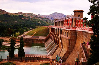
The Mettur Dam is one of the largest dams in India and also the largest in Tamil Nadu, located across the river Kaveri where it enters the plains. Built in 1934, it took 9 years to complete. Maximum height and width of the dam are 214 and 171 feet, respectively. The dam receives inflows from its own catchment area, Kabini Dam and Krishna Raja Sagara Dams located in Karnataka. There is a park at the base of the dam called Ellis Park maintained by the Tamil Nadu Public Works Department. It provides irrigation and drinking water facilities for more than 12 districts of Tamil Nadu and hence is revered as the life and livelihood-giving asset of Tamil Nadu.

Hogenakkal Falls is a waterfall in South India on the Kaveri river on the border between Dharmapuri district of Tamil Nadu and Chamrajnagar district of Karnataka. It is located 46 km (29 mi) from Dharmapuri district headquarter and 199 km (124 mi) from Chamrajnagar district headquarter. It is also located 127 km (79 mi) from Bangalore, 181 km (112 mi) from Mysore, 344 km (214 mi) from Chennai and 200 km (120 mi) from Coimbatore. It is sometimes referred to as the "Niagara Falls of India," it is known for bathing areas and hired boat rides and as a major tourist attraction. Carbonatite rocks in this site are considered to be the oldest of its kind in South Asia and one of the oldest in the world. The Government of Tamil Nadu made a proposal to convert the falls into providing drinking water for the state.
Salem District is one of the 38 districts of Tamil Nadu state in southern India. The district is now divided into Dharmapuri, Krishnagiri, Namakkal as individual districts. Salem is the district headquarters and other major towns in the district include Mettur, Thammampatti, Attur, Omalur, Sankagiri and Edappadi. That Salem dates to at least two thousand years ago is evident from the discovery of silver coins from the Roman Emperor Nero Claudius Caesar Augustus Germanicus found by Koneripatti of Salem in 1987. It was ruled by Mazhavar King Kolli Mazhavan and kings Adhiyaman and Valvil Ori of Sangam age. It is part of Mazhanadu, a vast region that dates to the second century BCE. Salem was the largest district of Tamil Nadu. It was bifurcated into Salem and Dharmapuri districts in 1965 and Namakkal district in 1997. Now Salem has been developed a lot by building many bridges and is considered to be the smart city. Salem is famous for cultivating mangoes.

Sir George Frederick Stanley was a British soldier and Conservative Party politician who served as a member of the UK Parliament for Preston and later, Willesden East. He also served the Governor of Madras from 1929 to 1934 and as Acting Viceroy of India in 1934.
Mullaperiyar DamIPA: [mulːɐpːeɾijɐːr], is a masonry gravity dam on the Periyar River in the Indian state of Kerala It is located 881 m (2,890 ft) above the sea level, on the Cardamom Hills of the Western Ghats in Thekkady, Idukki District of Kerala, India. It was constructed between 1887 and 1895 by John Pennycuick and also reached in an agreement to divert water eastwards to the Madras Presidency area. It has a height of 53.6 m (176 ft) from the foundation, and a length of 365.7 m (1,200 ft). The Periyar National Park in Thekkady is located around the dam's reservoir. The dam is built at the confluence of Mullayar and Periyar rivers. The dam is located in Kerala on the river Periyar, but is operated and maintained by the neighbouring state of Tamil Nadu. Although the Periyar River has a total catchment area of 5398 km2 with 114 km2 downstream from the dam in Tamil Nadu, the catchment area of the Mullaperiyar Dam itself lies entirely in Kerala and thus not an inter-State river. On 21 November 2014, the water level hit 142 feet for first time in 35 years. The reservoir again hit the maximum limit of 142 feet on 15 August 2018, following incessant rains in the state of Kerala. In a UN report published in 2021, the dam was identified as one among the world's big dams which needs to be decommissioned for being 'situated in a seismically active area with significant structural flaws and poses risk to 3.5 million people if the 100+ years old dam were to fail'.

Tamil Nadu is the second richest and largest economical state in India and is the most industrialised state in the country. More than 60% of the state is urbanized, accounting over 10.6% of the urban population in the country, while only comprising 6% of India's total population. Services contributes to 55% of the economic activity in the state, followed by manufacturing at 34% and agriculture at 11%. Government is the major investor in the state, with 52% of total investments, followed by private Indian investors at 29.9% and foreign private investors at 14.9%. It has been ranked as the most economically free state in India by the Economic Freedom Rankings for the States of India.

Veeranam Lake is located 14 km (8.7 mi) SSW in Cuddalore district in the state of Tamil Nadu in South India 1 km from Kattumannarkoil. It is located 235 km (146 mi) from Chennai, India. It is one of the water reservoirs from where water is supplied to Chennai city. The lake has a capacity to store about 1,465 mcft of water. Though the level in the Veeranam lake has dipped to 323 million cubic feet (mcft), the same amount of 180 mld was being drawn for city supply.

The Vaigai Dam is built across the Vaigai River near Andipatti, in the Theni district of Tamil Nadu, southern India. Near the dam, the Government of Tamil Nadu has constructed an Agricultural Research Station for researching the growing of a variety of crops, including rice, sorghum, blackgram, cowpea and cotton.
The Krishnagiri Dam is a dam that spans the Thenpennai River by the village of Dhuduganahalli, located in Krishnagiri district, Tamil Nadu, India. The Krishnagiri Dam is also known as Krishnagiri ReservoirProject (KRP) Dam. The KRP Dam is located 7 km (4.3 mi) from Krishnagiri, between Dharmapuri and Krishnagiri which irrigates thousands of acres of land around Krishnagiri. The Dam is operational from 10 November 1957, inaugurated by the Chief Minister of Tamil Nadu K. Kamaraj.
Lower Mettur Hydroelectric Project is a hydropower generation project in the South Indian state of Tamil Nadu. It is a 120MW power generation project constructed across the Kaveri River. The project area is in the downstream of Mettur Dam, hence it derives the name. This project consists of four power plants which are located between Mettur in Salem district and Bhavani, Erode. This power generation project is owned by Government of Tamil Nadu and operated by TANGEDCO.
Bhavani Kattalai Hydroelectric Project is a hydropower generation project in the South Indian state of Tamil Nadu. It is a 90MW power generation project constructed across the Kaveri River. The project area is in the downstream of Lower Mettur Hydroelectric Project. This project consists of three power plants which are located between Bhavani and Pasur, Erode. This hydropower generation project is owned by Government of Tamil Nadu and operated by TANGEDCO.


