Tawi River

Last updated

Tawi River
Surajputri
Jammu Tawi.jpg
Location
CountryFlag of India.svg  India
Flag of Pakistan.svg  Pakistan
Region Jammu and Kashmir

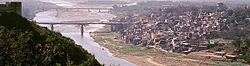
The Tawi is a river that flows through the Jammu region in the Indian-administered Jammu and Kashmir and Pakistan-administered Azad Jammu and Kashmir. [1] The Tawi is a major left bank tributary of the river Chenab. [1]

Contents

Origin and coarse of flow

Tawi river originates from Kailash Kund glacier in Bhaderwah Doda district, and then flows through the Seoj Dhar meadows in Doda district. Its catchment is delineated by latitude 32°35'-33°5'N and longitude 74°35'-75°45'E. The catchment area of the river up to Indian border (Jammu) is 2168 km² and falls in the districts of Jammu, Udhampur and a small part of Doda. Elevation in the catchment varies between 400 and 4000 m.

The length of Tawi river is about 141 km (88 mi). The river in general flows through steep hills on either side excepting the lower reach for about 35 km (22 mi). The river is about 300 m (980 ft) wide at the bridge in Jammu city. The height of Gujjar Nagar bridge is 90m.

After traversing Jammu city, the river crosses into Pakistan's Punjab and joins Chenab river.

Artificial lake project

Jammu and Kashmir government is constructing an artificial lake on River Tawi at Bhagwati Nagar in Jammu to promote tourism and supply water to dry areas of the city. A team of Pakistani officials visited the site and studied the details of the project which will help allay any apprehensions about violation of provisions of Indus Water Treaty. [2]

See also

Related Research Articles

<span class="mw-page-title-main">Baltistan</span> Region of Pakistani-administered Kashmir

Baltistan also known as Baltiyul or Little Tibet, is a mountainous region in the Pakistani-administered territory of Gilgit-Baltistan and constitutes an northern portion of the larger Kashmir region that has been the subject of a dispute between India and Pakistan since 1947. It is located near the Karakoram and borders Gilgit to the west, China's Xinjiang to the north, Indian-administered Ladakh to the southeast, and the Indian-administered Kashmir Valley to the southwest. The average altitude of the region is over 3,350 metres (10,990 ft). Baltistan is largely administered under the Baltistan Division.

<span class="mw-page-title-main">Karakoram Highway</span> International highway running through Pakistan and China

The Karakoram Highway is a 1,300 km (810 mi) national highway which extends from Hasan Abdal in the Punjab province of Pakistan to the Khunjerab Pass in Gilgit-Baltistan, where it crosses into China and becomes China National Highway 314. The highway connects the Pakistani provinces of Punjab and Khyber Pakhtunkhwa plus Gilgit-Baltistan with China's Xinjiang Uyghur Autonomous Region. The highway is a popular tourist attraction and is one of the highest paved roads in the world, passing through the Karakoram mountain range, at 36°51′00″N75°25′40″E at maximum elevation of 4,714 m (15,466 ft) near Khunjerab Pass. Due to its high elevation and the difficult conditions under which it was constructed, it is often referred to as the Eighth Wonder of the World. The highway is also a part of the Asian Highway AH4.

<span class="mw-page-title-main">Jhelum River</span> River in India and Pakistan

The Jhelum River is a river in the northern Indian subcontinent. It originates at Verinag and flows through the Indian-administered territory of Jammu and Kashmir, into Pakistani-administered Azad Kashmir, then the Pakistani province of Punjab. It is the westernmost of the five rivers of the Punjab region, and flows through the Kashmir Valley. It is a tributary of the Chenab River and has a total length of about 725 kilometres (450 mi).

<span class="mw-page-title-main">Chenab River</span> River in India and Pakistan

The Chenab River is a major river that flows in India and Pakistan, and is one of the 5 major rivers of the Punjab region. It is formed by the union of two headwaters, Chandra and Bhaga, which rise in the upper Himalayas in the Lahaul region of Himachal Pradesh, India. The Chenab flows through the Jammu region of Jammu and Kashmir, India into the plains of Punjab, Pakistan, before ultimately flowing into the Indus River. The Battle of Chenab was fought between Sikhs and Afghans on the bank of the river.

<span class="mw-page-title-main">Kashmir Valley</span> Valley in Jammu & Kashmir, India

The Kashmir Valley, also known as the Vale of Kashmir, is an intermontane valley in northern Jammu and Kashmir, a region in Indian-administered Kashmir. The valley is surrounded by ranges of the Himalayas, bounded on the southwest by the Pir Panjal Range and on the northeast by the Greater Himalayan range. It is approximately 135 km (84 mi) long and 32 km (20 mi) wide, and drained by the Jhelum River. It forms the bulk of the Kashmir Division of Jammu and Kashmir.

<span class="mw-page-title-main">Doda district</span> District in Jammu and Kashmir

Doda district is an administrative district of the Jammu division of Indian-administered Jammu and Kashmir in the disputed Kashmir region.

<span class="mw-page-title-main">Pir Panjal Range</span> Mountain range of the Lower Himalayas

The Pir Panjal Range is a range of mountains in the Lower Himalayan region located in the Western Himalayas of northern Indian subcontinent. It runs southeast to northwest between the Beas and Neelam/Kishanganga rivers, in the Indian state of Himachal Pradesh and Indian-administered union territory of Jammu and Kashmir, with its northwestern end extending into territory administered by Pakistan. The Himalayas show a gradual elevation towards the Dhauladhar and Pir Panjal ranges. Pir Panjal is the largest and westernmost range of the Lesser Himalayas. Near the bank of the Sutlej River, it dissociates itself from the main Himalayan range and forms a divide between the Beas and Ravi rivers on one side and the Chenab on the other. Further west, the Pir Panjal range forms the southwestern boundary of the Kashmir Valley, separating it from the hills of Jammu region, forming a divide between the Jhelum and Chenab rivers.

<span class="mw-page-title-main">Dras River</span> River in Ladakh, India

The Dras River, also spelt Drass River, is a river in the Kargil district in the Indian union territory of Ladakh. It originates below the Zoji La pas in the Great Himalayan range and flows northeast towards Kargil, where it joins the Suru River. The Shingo River, which flows in a parallel direction in Pakistan-administered Baltistan, also joins the Drass River. The combined river is alternatively called Suru, Drass and Shingo by various local groups.

<span class="mw-page-title-main">Akhnoor</span> City in Jammu and Kashmir, India

Akhnoor is a city and municipal committee, near city of Jammu in Jammu district of Indian union territory of Jammu and Kashmir. It lies 28 km away from Jammu city. Akhnoor is on the bank of the Chenab River, just before it enters the Pakistani Punjab. Its border location gives it strategic significance. The Akhnoor area is divided into three administrative sub-divisions - Akhnoor, Chowki Choura and Khour; Seven Tehsils - Akhnoor Khaas, Chowki Choura, Maira Mandrian, Jourian, Kharah Balli, Khour & Pargwal.

<span class="mw-page-title-main">Marala Headworks</span> Barrage in Punjab, Pakistan

Marala Headworks is a headworks situated on the Chenab River near the city of Sialkot in Gujrat district in Punjab, Pakistan. A weir was first built during 1906–1912 in the British India to feed the Upper Chenab Canal, as part of the 'Triple Canals Project'. A new Marala Barrage was constructed in 1968 to feed the Marala–Ravi Link Canal in addition to the original Upper Chenab Canal.

<span class="mw-page-title-main">Tourism in Jammu and Kashmir</span> Tourist places in Jammu and Kashmir

Jammu and Kashmir is home to several valleys such as the Kashmir Valley, Chenab Valley, Sindh Valley and Lidder Valley. Some major tourist attractions in Jammu and Kashmir are Srinagar, with its renowned Dal Lake and Mughal Gardens, Gulmarg, Pahalgam, Bhaderwah, Patnitop and Jammu. Every year, thousands of Hindu pilgrims visit holy shrines of Vaishno Devi and Amarnath which has had a significant impact on the state's economy.

<span class="mw-page-title-main">Ramban district</span> District of Jammu and Kashmir administered by India

Ramban district is an administrative district in the Jammu division of Indian-administered Jammu and Kashmir in the disputed Kashmir region. It is located in a valley surrounded the Pir Panjal range. It was carved out as a separate district from erstwhile Doda district in 2007. It is located in the Jammu division. The district headquarters are at Ramban town, which is located midway between Jammu and Srinagar along the Chenab river in the Chenab valley on National Highway-44, approximately 151 km from Jammu and Srinagar.

<span class="mw-page-title-main">Kishtwar district</span> District of Jammu and Kashmir, India

Kishtwar district is an administrative district of the Jammu division of Indian-administered Jammu and Kashmir in the Jammu Division. As of 2011, it is the largest and the least populous district of Jammu and Kashmir.

Chowki Choura, Akhnoor, is a Sub-Division in Jammu district in Jammu and Kashmir, India.

<span class="mw-page-title-main">Chenab Valley</span> Valley and proposed administrative division in Jammu and Kashmir, India

The Chenab Valley is a river valley formed by the Chenab River. The term is also used collectively for Doda, Kishtwar and Ramban districts of Jammu Division in the Indian-administered Jammu and Kashmir. These districts were formerly part of a single district, called Doda.

<span class="mw-page-title-main">Jalandhar–Jammu line</span> Railway line in India

The Jalandhar–Jammu line is a railway line connecting Jalandhar Cantonment and Jalandhar City in the Indian state of Punjab with Jammu Tawi in Jammu and Kashmir. The line is under the administrative jurisdiction of Northern Railway. This line was made after Indian Independence in 1947. Normally before partition of India and creation of Pakistan, trains to Jammu Tawi from Delhi used to run via Panipat, Ambala Cantonment, Ludhiana, Jalandhar City, Amritsar, Lahore, Narowal and Sialkot. But after partition and creation of Pakistan in 1947, the Sialkot–Jammu Tawi line was dismantled and closed permanently. Jammu and Kashmir became cut off from rest of India. Hence in 1949, it was decided to extend the line from Jalandhar City to Mukerian till Pathankot and after the Indo-Pakistani War of 1965, this line was extended to Jammu Tawi. This 216 km (134 mi) railway line is an important strategic connectivity for Indian Military and Defence.

<span class="mw-page-title-main">Jammu division</span> Administrative division in Jammu and Kashmir, India

The Jammu division is a revenue and administrative division of the Indian-administered Jammu and Kashmir in the disputed Kashmir region. It is bordered by the Kashmir division to the north. It consists of the districts of Jammu, Doda, Kathua, Ramban, Reasi, Kishtwar, Poonch, Rajouri, Udhampur and Samba. Most of the land is hilly or mountainous, including the Pir Panjal Range which separates it from the Kashmir Valley and part of the Great Himalayas in the eastern districts of Doda and Kishtwar. Its principal river is the Chenab.

The Manawar Tawi river is a tributary of the Chenab River, which originates at the Ratan Pir ridge of the Pir Panjal Range and flows through the Rajouri and Jammu districts of Jammu and Kashmir, India and the Sialkot District of Pakistani Punjab, where it joins the Chenab at Marala Headworks. The towns along its course include Thana Mandi, Rajouri and Naushera. Towards the end of its course, it flows through the plains of the Jammu district west of Akhnur close to the Line of Control dividing the Pakistan-administered and Indian-administered Kashmir regions.

Neeru river or Neru river is the river tributary of the Chenab River, beginning at the Sonbain Ashapati Glacier of the Bhaderwah and joining the Chenab at Pul Doda in the Doda district. The Gupt Ganga temple of Bhaderwah is located on the bank of this river.

The Kalnai River is a tributary of the Chenab River in the Bunjwah region bordering Kishtwar and Doda districts in Jammu and Kashmir. An under construction 48MW Lower Kalnai hydroelectric project is located at Donadi on this river.

References

  1. 1 2 Negi, Sharad Singh (1991). Himalayan Rivers, Lakes, and Glaciers. Indus Publishing. ISBN   978-81-85182-61-2.
  2. "Panel from Pakistan in Jammu to survey lake project on Tawi". Hindustan Times. Archived from the original on 23 February 2011.

32°41′03″N74°29′01″E / 32.6842°N 74.4837°E / 32.6842; 74.4837