West Rapti River

Last updated

West Rapti
Kuwano
Pulchowk, Bhalubang, Deukhuri, Dang.jpg
West Rapti river at Bhalubang
Location
Country Nepal, India
Physical characteristics
Source 
  location Rapti Zone, Nepal south of border of Rukum District with Rolpa District
  coordinates 28°28′33″N82°52′44″E / 28.4757°N 82.8788°E / 28.4757; 82.8788
  elevation3,500 m (11,500 ft)
Mouth  
  location
Ghaghara River
  coordinates
26°17′20″N83°40′08″E / 26.289°N 83.669°E / 26.289; 83.669
  elevation
60 m (200 ft)
Basin size23,900 km2 (9,200 sq mi)
Discharge 
  average136 m3/s (4,800 cu ft/s)
Basin features
River system Ganges
Tributaries 
  leftLungri Khola, Jhimruk Khola, Ami River, Rohini River
  rightArun Khola,

The West Rapti, also known as the Kuwano, is a river which drains Rapti Zone in Mid-Western Region, Nepal, then Awadh and Bhojpur-Purvanchal regions of Uttar Pradesh state, and finally India before joining the Ghaghara. It is a major left bank tributary of the Ganges, and is also known as the Karnali in Nepal.

Contents

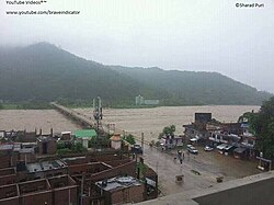
The West Rapti is notable for janajati ethnic groups – Kham Magar among its highland sources and then Tharu in Inner Terai Deukhuri Valley, for its irrigation and hydroelectric potential, and for recurrent floods that led to its nickname "Gorakhpur's Sorrow".

Max depth 8.50

Min depth 10.7

History

As ancient Airavati river

Aciravati, Achirvati or Airavati is the ancient name for a river has been identified with the modern Rapti, flowing through what is now Nepal and the northern portion of Uttar Pradesh. [1] [2] The Chinese pilgrim Xuanzang knew it as A-chi-lo. Jain texts mention it as Eravai. [2]

The ancient city of Sravasti, once capital of Kosala Kingdom, stood on the western bank of the Achirvati. The river was a tributary of the Sarayu. It was one of the five great rivers that constituted the Ganges group of rivers and one of the sacred rivers of the Buddhist midland. [2] [3]

Geography

The Rapti rises south of a prominent E-W ridgeline midway between the western Dhaulagiri Himalaya and the Mahabharat Range. A 3,500 metres (11,500 ft) summit on this ridgeline marks a triple divide. North of the triple divide the Karnali and Gandaki basins are adjacent; south of it the Rapti and similar but smaller Babai River (Nepali : बबई नदी; Babaī Nadī) separate the two larger basins. After crossing into India, the Babai and Rapti separately join the Karnali's continuation called Ghaghara. The Ghaghara ultimately joins the Ganges.

Hydrology

The Rapti's headwaters descend south from rugged highlands populated by Kham Magar. The western tributary Mādī Kholā (Nepali : माडी खोला) rises in northwestern Rolpa and is joined by Lungrī Kholā (Nepali : लुङग्री खोला) draining northeastern Rolpa. The Mardi then crosses into Pyuthan. It is joined by east-flowing Arun Kholā (Nepali : अरुण खोला) at Devithān (Nepali : देवीथान) where it enters a gorge through the Mahabharat Range.

Jhimruk Kholā (Nepali : झिमरुक खोला) -- east of the Mardi—mainly drains Pyuthan. Below the upper highlands, an alluvial valley opens where Bahun and Chhetri rice farmers irrigate paddy fields. At Cherneta, Pyuthan the Jhimruk approaches within 1.5 km of the Mardi and a 12 megawatt hydroelectric plant exploits the Jhimruk being 200 meters higher.

Below Cherneta the Jhimruk loops east, becoming the border between Pyuthan and Arghakhanchi District. Its valley narrows and steepens as it enters the Mahabharat Range. Partway through it joins the Mardi and the combined flow is then named the Rapti. The main river emerges from its gorge into the lower Siwalik Hills and Dang District. At Bhalubang Bazaar Nepal's east-west Mahendra Highway bridges the river.

Below Bhalubang, Inner Terai Deukhuri Valley opens between the Dang and Dudhwa Ranges , both sub ranges of the Siwaliks. Valley, following the WNW trend of the Siwalik hills for 100 km. Although the land is fertile, before DDT came into use in the 1950s Deukhuri was so malarial that only the Tharu people who had genetic resistance could be confident of surviving the warmer months.

The river crosses from Dang into Banke District. Approaching Nepalganj—largest town in Nepal's western Terai—the Dudhwa Hills fall away and the river turns SE, crossing into Uttar Pradesh, India and flowing through districts Shravasti, Siddharth Nagar, Basti, Sant Kabir Nagar, Maharajganj District and Gorakhpur, passing Gorakhpur city at about 135 air miles (215 km) from Nepal.[ citation needed ]

Just west of the city it is joined by the smaller Rohini rising further east in Nepal's Nawalparasi and Rupandehi Districts, draining 794 km2 in Nepal then 1892 km2 following through Maharajganj District in India. 60 km beyond Gorakhpur the Rapti joins the Ghaghara (Karnali) at Rajpur. About 120 km further on at Chhapra, the Ghaghara reaches the Ganges. [4] [5] [6] [7]

Resource utilisation

The Rapti's flow has great seasonal variation because the river lacks sources in high elevation glaciers and snowfields to buffer pre-monsoon drought. Average monthly flows at Jalkundi (27°58'N, 82°14'E) in Deukhuri Valley vary from 17.6 m3/s in pre-monsoon April to 451 m3/s at the peak of the monsoon in August. Maximum recorded flood was 7,390 m3/s on 10 September 1981. 100-year flood flows are predicted at 10,100 m3/s. Every year, floods threaten over 700,000 acres (280,000 ha) in Uttar Pradesh.[ citation needed ]

Flood control projects under study include a dam at Jalkundi that would inundate 71,000 acres (29,000 ha) of farmland in Deukhuri Valley. An alternative dam site is upstream at Naumure on the Pyuthan-Dang district border (27°53'N, 82°48'E). This would be an earthen dam 169 m high with 351 million cubic meters live storage capacity, storing excess monsoon flows for irrigation use during the following dry season and generating up to 207 megawatts. Impoundment would mainly be in gorges through the Mahabharat Range, inundating less farmland than the Jalkundi alternative. Plans are also underway for three irrigation sub-projects – Kapilvastu District 30,500 hectares (75,000 acres) involving interbasin water transfer to the southeast, Deukhuri Valley 9,500 hectares (23,000 acres), and Banke District 40,000 hectares (99,000 acres). [8]

Related Research Articles

<span class="mw-page-title-main">Rapti Zone</span> Former administrative area in Nepal

Rapti Zone was one of the fourteen zones, located in the Mid-Western Development Region of Nepal. It was named after the West Rapti River which drains Rolpa, Pyuthan and part of Dang districts. The remainder of Dang and part of Salyan district are drained by the Babai. The remainder of Salyan and all of Rukum districts are drained by the Bheri.

<span class="mw-page-title-main">Arghakhanchi District</span> District in Lumbini Province, Nepal

Arghakhanchi is one of the districts of Lumbini Province in Nepal. The district headquarter is Sandhikharka. The district covers an area of 1,193 km2 (461 sq mi) and has a population (2011) of 197,632. Its neighboring districts are Palpa in the east, Gulmi in the north, Kapilvastu District in the south and Pyuthan in the west. The district also covers 4.18km of daily busy road connecting Kapilvastu and Bhalubang, Lalmatiya, Dang with Rapti River as Mahendra Highway or Easy-West Highway.

<span class="mw-page-title-main">Ghaghara</span> Asian river and tributary of the Ganges

The Ghaghara River, called Karnali River in Nepal, Mapcha Tsangpo in Tibet, and the lower Ghaghara in Awadh called Sarayu River, is a perennial trans-boundary river that originates in the northern slopes of the Himalayas in the Tibetan Plateau, cuts through the Himalayas in Nepal and joins the Sharda River at Brahmaghat in India. Together they form the Ghaghara River, a major left-bank tributary of the Ganges. With a length of 507 km (315 mi), it is the longest river in Nepal. The total length of the Ghaghara up to its confluence with the Ganges at Revelganj in Bihar is 1,080 km (670 mi). It is the largest tributary of the Ganges by volume and the second largest by length after Yamuna.

<span class="mw-page-title-main">Banke District</span> District in Lumbini Province, Nepal

Banke District (Nepali: बाँके जिल्ला, romanized: Bām̐kē jillā;, a part of Lumbini Province, is one of the 77 districts of Nepal. The district, located in midwestern Nepal with Nepalganj as its district headquarters, covers an area of 2,337 km2 and had a population of 385,840 in 2001 and 491,313 in 2011. There are three main cities in the Banke District: Nepalganj, Kohalpur and Khajura Bajaar.

<span class="mw-page-title-main">Bardiya District</span> District in Lumbini Province, Nepal

Bardiya District, one of the seventy-seven Districts of Nepal, is part of Lumbini Province of Nepal. The district, with Gulariya as its headquarters, covers an area of 2,025 km2 (782 sq mi) and according to the 2001 census the population was 382,649 in 2011 it has 426,576.

<span class="mw-page-title-main">Dang District, Nepal</span> District in Lumbini Province, FDR Nepal

Dang District is the district of Lumbini Province located in the Inner Terai of midwestern Nepal. Deukhuri valley of the district is the capital of the province and is the second largest valley of Asia surrounded by Sivalik Hills and Mahabharata Range. The district headquarter Ghorahi is the seventh largest city and the largest sub-metropolitan city of Nepal. Tulsipur sub-metropolitan city, the second largest city of Dang, is a major transportation hub with an extensive road and air networks. The district covers an area of 2,955 km2 and has a population of 548,141.

<span class="mw-page-title-main">Pyuthan District</span> District in Lumbini Province, Nepal

Pyuthan District (Nepali: प्युठान जिल्ला, is a "hill" district some 427.6 km west of Kathmandu in Lumbini Province in midwestern Nepal. Pyuthan covers an area of 1,309 km2 with population of 212,484 in 2001 and 226,796 in 2011. Pyuthan Khalanga is the district's administrative center.

<span class="mw-page-title-main">Salyan District, Nepal</span> District of Karnali Province,Nepal

Salyan District IPA: [sʌljan], a part of Karnali Province, is one of the seventy-seven districts of Nepal. Salyan covers an area of 1,462 km2 (564 sq mi) with a population of 213,500 in 2001 and 241,716 in 2011. The district's administrative center is named Salyan or Salyan Khalanga, today it is part of Shaarada Municipality.

Pyuthan is a municipality in the Pyuthan District in the Lumbini Province of Nepal. This municipality is named after the district name Pyuthan. It is also the major market center and the administrative center of district. The municipality was established on 18 May 2014 by merging the existing VDCs Khaira, Dakha Kwadi, Bijaya Nagar, Bijuwar, Dharmawati, Maranthana and Khalanga village development committees. In 2017, when GoN restructured the local level bodies into 753 units, Pyuthan Municipality was also restructured excluding ward no. 1, 2, 3, 5 and 18 from old structure, further two other VDCs; Majhkot and Jumrikanda added, Khalanga separated and managed the municipality into 10 new wards. Nayabajar Jumri and Bijuwar are the major markets of Pyuthan Municipality.

<span class="mw-page-title-main">Ghorahi</span> Sub-Metropolitan City in Lumbini, Nepal

Ghorahi is the largest sub-metropolitan city by area and population of Lumbini Province. The city lies in Lumbini Province in the Mid-Western part of Nepal. It is the largest city of Dang Deukhuri District of southwest Nepal. Located in the Inner Terai region, it lies 413 kilometres (257 mi) south-west of Nepal's capital Kathmandu and is one of the Counter Magnets being developed as an alternative centre of growth to help ease the migration and population explosion in the Kathmandu metropolitan area. It is the largest city of the Rapti Zone and is surrounded by the Sivalik Hills to the south and Mahabharata Range to the north.

<span class="mw-page-title-main">Mahendra Highway</span> Major road in Nepal

Mahendra Highway, also called East-West Highway, runs across the Terai geographical region of Nepal, from Mechinagar in the east to Bhim Datta in the west, cutting across the entire width of the country. It is the longest highway in Nepal and was constructed in cooperation with various countries. The highway is named after King Mahendra Shah.

The Inner Terai Valleys of Nepal comprise several elongated river valleys in the southern lowland Terai part of the country. These tropical valleys are enclosed by the Himalayan foothills, viz the Mahabharat Range and the Sivalik Hills farther south.

Koilabas is a bazaar town situated in Gadhawa Rural Municipality in Dang Deokhuri District in Lumbini Province of south-western Nepal. The town is situated on the southern edge of the Dudhwa Range of the Siwaliks, at Nepal's border with Uttar Pradesh 5 km from the village Jarwa on the other side. Indian and Nepalese nationals may cross the border unrestricted however there is a customs checkpoint for goods. Koilabas has regular bus service to Tulsipur on the Gorakhpur-Gonda Loop of Indian Railways.

Tiram is a town and Village Development Committee in Pyuthan, a Middle Hills district of Rapti Zone, western Nepal.

<span class="mw-page-title-main">Tulsipur State</span>

Tulsipur State was a small kingdom in the Awadh region of India that became the United Provinces of Agra and Oudh under the British Raj and Dundwa Range of the Siwaliks in the Dang and Deukhuri Valleys that became part of the Kingdom of Nepal. It was one of the areas traditionally inhabited by the Tharu people.

<span class="mw-page-title-main">Babai River</span> River in South Asia

The Babai River originates in and completely drains Inner Terai Dang Valley of Mid-Western Nepal. Dang is an oval valley between the Mahabharat Range and Siwalik Hills in its eponymous district. Dang was anciently home to indigenous Tharu people and came to be ruled from India by the House of Tulsipur who also counted as one of the Baise Rajya —a confederation of 22 petty kingdoms in the Karnali (Ghagra) region. About 1760 AD all these kingdoms were annexed by the Shah Dynasty during the unification of Nepal, except Tulsipur lands south of the Siwalik Hills were not taken. Since Dang Valley was somewhat higher, cooler, better-drained and therefore less malarial than most of the country's Inner Terai, it was settled to some extent by Shah and Rana courtiers and other Paharis long before DDT was introduced to control the disease-bearing Anopheles mosquito.

<span class="mw-page-title-main">Lumbini Province</span> Province of Nepal

Lumbini Province is a province in western Nepal. The country's third largest province in terms of area as well as population, Lumbini is home to the World Heritage Site of Lumbini, where according to the Buddhist tradition, the founder of Buddhism, Gautama Buddha was born.

<span class="mw-page-title-main">Bauraha khola</span> River in Nepal

Bauraha khola, sometimes Baulaha khola is a stream in Gadhawa Rural Municipality ward number 1 Dang Deukhuri District Nepal. It irrigates the land of Banghushree 12 months. The water level rises in monsoon season. It runs from south to north between Banghushree and Badahara village, originating from southern Chure hills of Banghushree Dang Deukhuri District Nepal; near 'Bauraha Kapilvastu' such as Saani Bauraha, Thulo Bauraha, Kalyankot, Domai, Gangare, and Gogan paani. Chureni khola, Sota, Bhutaiya khola and Bagaiya khola are tributaries of Bauraha khola. Sanghuri ।सॉघुरी।, an area of vertical slope with a narrow opening, is a place where stream accumulates its strength. In the monsoon season, it causes a huge loss of property. The upper large catchment area where high precipitation in monsoon season results devastating flash floods each year, impacting the locals of Banghushree. Bauraha khola, which generally carries mud, boulders and much debris due to steep slope, sweeps the fertile land of Banghushree each year. It ends its presence by mixing with West Rapti River near at Banghushree. Both Damodar road and Dulaiya road cross Bauraha khola to connect Banghushree with Badahara village. There is no solid infrastructure built to cross the stream Bauraha khola.

<span class="mw-page-title-main">Deukhuri</span> Capital of Lumbini Pradesh, Federal Democratic Republic of Nepal

Deukhuri, also known as Deukhuri Valley, is a proposed permanent capital of Lumbini Province in Nepal which was decided on 20th of Aswin 2077 BS. The temporary capital of Lumbini is in Butwal.

Jhimruk Khola Hydropower Station is a run-of-river hydro-electric plant located in Pyuthan District of Nepal. The flow from Jhimruk River, a tributary of West Rapti River, is used to generate 12 MW electricity and annual energy of 72 GWh. The flow is transferred to Madi River at the tailrace. The powerhouse is semi-underground type located on the bank of the Madi River. The plant is owned and developed by Butwal Power Company Limited, an IPP of Nepal in technical help from UMN. The plant started generating electricity since 2052-01-25 BS. The generation licence will expire in 2101-12-30 BS, after which the plant will be handed over to the government. The power station is connected to 132 kV national grid through 41 km long transmission line at Lamahi substation. The electricity is sold to Nepal Electricity Authority.

References

  1. Hoey, William. (1907). "The Five Rivers of the Buddhists". Journal of the Royal Asiatic Society of Great Britain and Ireland. 39: 41–46. doi:10.1017/S0035869X00035498. S2CID   161844172 . Retrieved 10 March 2011.
  2. 1 2 3 Kapoor, Subodh (2002). Encyclopaedia of Ancient Indian Geography. Cosmo Publications. ISBN   9788177552980 . Retrieved 18 August 2010.{{cite book}}: |work= ignored (help)
  3. W. Hoey. "The Five Rivers of the Buddhists". Journal of the Royal Asiatic Society of Great Britain and Ireland 1907, pp. 41-46. Retrieved 18 August 2010.
  4. "Rapti River". india9. Retrieved 28 May 2010.
  5. "Basti". Basti district administration. Retrieved 30 May 2010.
  6. "Sant Kabir Nagar district". Sant Kabir Nagar district administration. Retrieved 30 May 2010.
  7. Negi, Sharad Sing (1991). Himalayan rivers, glaciers and lakes. Indus. ISBN   9788185182612 . Retrieved 28 May 2010.{{cite book}}: |work= ignored (help)
  8. Dwarika N. Dhungel, Santa B. Pun (18 January 2009). The Nepal-India Water Relationship: Challenges. Springer. ISBN   9781402084034 . Retrieved 28 May 2010.{{cite book}}: |work= ignored (help)