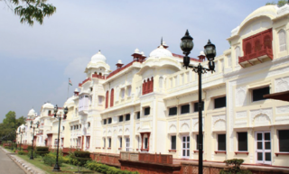
Patiala is a city in southeastern Punjab, northwestern India. It is the fourth largest city in the state and is the administrative capital of Patiala district. Patiala is located around the Qila Mubarak constructed by the Sidhu Jat chieftain Ala Singh, who founded the royal dynasty of Patiala State in 1763, and after whom the city is named.

Kanpur or Cawnpore is an industrial city in the central-western part of the state of Uttar Pradesh, India. Founded in 1803, Kanpur became one of the most important commercial and military stations of British India. Kanpur is also the financial capital of Uttar Pradesh. Nestled on the banks of Ganges River, Kanpur stands as the major financial and industrial centre of North India and also the ninth-largest urban economy in India. Today it is famous for its colonial architecture, gardens, parks and fine quality leather and textile products which are exported mainly to the West.

Aligarh is a city in the state of Uttar Pradesh in India. It is the administrative headquarters of Aligarh district, and lies 307 kilometres (191 mi) northwest of Kanpur and approximately 130 kilometres (81 mi) southeast of the capital, New Delhi. The districts which adjoin Aligarh are Gautam Buddha Nagar, Bulandshahr, Sambhal, Badaun, Kasganj, Hathras, Etah and Mathura. As of 2011, Aligarh is the 53rd most populous city in India.
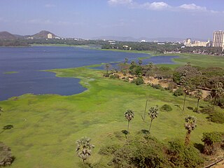
Powai Lake is an artificial lake, situated in Mumbai, in the Powai valley, where a Powai village with a cluster of huts existed. The city suburb called Powai shares its name with the lake. Indian Institute of Technology Bombay, one of the premier institutions of science and technology in India, is located to the east of the lake. Another famous institution, the National Institute of Industrial Engineering (NITIE), is also located close to the lake. Housing complexes and plush hotels are developed all around the lake periphery. Population around the lake has thus substantially increased over the years.

Etawah also known as Ishtikapuri is a city on the banks of Yamuna River in the state of Western Uttar Pradesh in India. It is the administrative headquarters of Etawah District. Etawah's population of 256,838 makes it the one hundred and eightieth-most populous city in India. The city lies 300 km (190 mi) southeast of the national capital New Delhi, and 230 km (140 mi) northwest of the state capital Lucknow.

Unnao is a city in Indian state of Uttar Pradesh. It is the administrative headquarters of Unnao district and a part of Lucknow division, between Kanpur and Lucknow. Unnao is a large industrial city with three industrial suburbs around it. The city is famous for its leather, mosquito net, Zardozi and chemical industries. Unnao is an historical city with many historical buildings and structures. Trans Ganga City, a new satellite town of Unnao is being developed in order to develop Unnao as a major industrial and infrastructural hub as the region comes under Kanpur-Lucknow Counter Magnet Area. Unnao district is a part of Central Ganges Plain of the state covering an area of 4558 km2. The city is enlisted as a municipality of Kanpur metropolitan area and is the second largest city within the metropolitan area. nawabganj pakshi vihar located along NH27 is one of best place to see migratory birds which come from various countries during winter season and it has been included in the list of RAMSAR sites. Best time to visit this sanctuary is from November to March.

Munger, formerly spelt as Monghyr, is a twin city and a Municipal Corporation situated in the Indian state of Bihar. It is the administrative headquarters of Munger district and Munger Division. Munger was one of the major cities in Eastern India and undivided Bengal during Mughal period and British Raj. It is one of the major political,cultural,educational and commercial center of Bihar and Eastern India. Munger is situated about 180km from east of capital city Patna, about 480km west of Eastern India's largest city kolkata and 1200km from country's capital New Delhi.

Ghaziabad district is a city in the Indian state of Uttar Pradesh and a part of Delhi NCR. It is the administrative headquarters of Ghaziabad district and is the largest city in western Uttar Pradesh, with a population of 1,729,000. Ghaziabad Municipal Corporation is divided into 5 zones - City Zone, Kavi Nagar Zone, Vijay Nagar Zone, Mohan Nagar Zone and Vasundhara Zone. The Municipal Corporation comprises 100 wards. Well connected by roads and railways, it is a major rail junction for North India.
Orai is a city in Uttar Pradesh, India. It is the administrative headquarters of Jalaun District. All administrative offices of Jalaun District, including the District Collectorate, police, telecom and various other government organizations are located in this city. Orai received the award of 'Fastest Mover' Small City among India under Swachh Survekshan 2019, an annual cleanliness survey carried by the Quality Council of India.
Kashipur is a city of Udham Singh Nagar district in the Indian state of Uttarakhand, and one of its seven subdivisions. Located in the western part of Udham Singh Nagar district, it is Kumaun's third most populous city and the sixth most populous in Uttarakhand. According to the 2011 Census of India, the population is 121,623 for the city of Kashipur and 283,136 for Kashipur Tehsil. Kashipur also has IIM Kashipur, one of the thirteen Indian Institutes of Managements the government has set up during the Eleventh Five-year Plan.
Akbarpur is a town in Kanpur Dehat district in the state of Uttar Pradesh, India.

Malampuzha Dam is the second largest dam and reservoirs in Kerala, located near Palakkad, in the state of Kerala in South India, built post independence by the then Madras state. Situated in the scenic hills of the Western Ghats in the background it is a combination of a masonry dam with a length of 1,849 metres and an earthen dam with a length of 220 metres making it the longest dam in the state. The dam is 355 feet high and crosses the Malampuzha River, a tributary of Bharathappuzha, Kerala's second longest river. There is a network of two canal systems that serve the dam's reservoir of 42,090 hectares.
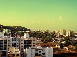
Pashan is suburb of Pune, India. It is located off the Mumbai-Bangalore national highway, by-passing Pune city. Pashan road serves as the main approach road for Mumbai-Pune expressway. Pashan is bordered by Baner in north, Sus on west, Bavdhan in south and Pune University in east. Pashan is mostly a residential suburb of Pune and large portions are occupied by various governmental and educational institutions. In October 2019, Pashan received more rainfall than the wettest place on Earth.

JK Temple is a Hindu temple in the Indian city of Kanpur, Uttar Pradesh, India. It is considered to be a unique blend of ancient and modern architecture. The mandapa of the temple has been constructed with high roof for adequate ventilation of light and air. The temple was constructed by JK Trust and major maintenance expenses of the temple also comes from the trust fund. The temple is also popularly known as Radhakrishna Temple.
The Ganges Barrage, officially named as the Lav Khush Barrage, this bridge across the Ganges river lies at Azad Nagar-Nawabganj in Kanpur.
Kanpur Cantonment is a military cantonment in Kanpur, Uttar Pradesh, India. The Kanpur Cantonment was established in the year 1811 and is situated on the right bank of river Ganges and is bound by Kanpur city area on the remaining three sides. Kanpur Cantonment is the largest cantonment in India, both by area and population. The area of the Cantonment is approx. 4243.0084 acres (17 km2) out of which the Bungalow Area is 3899.1784 acres and the Civil Area is 334.83 acres. As per 2011 Census, the population of Cantonment is 108,035 which is 453rd largest city of India.
Mandhana is a town in the Kanpur district of the Indian state of Uttar Pradesh, situated about 20 kilometres (12 mi) from Kanpur on the Grand Trunk Road to Delhi. As of the 2011 Census of India, the town had 213 households with a population of 993 of which 504 were male and 489 female. It has a 60% literacy rate and is 5 kilometres (3.1 mi) from Chobepur, its sister town. It also falls within the Kanpur metropolitan area. The language commonly spoken is Hindi with accent and tone of Kannauji. The IIT Kanpur is just 7 kilometres from Mandhana and also houses some of the successful alumnus of the institute. Mandhana is also known for private institutes like Maharana Pratap Engineering College and Rama University.
Rawatpur is a suburb in North Kanpur, India, situated about 10 km from Kanpur on the NH 91 to Delhi. The population was 110,000 at the 2001 census. It has 84% of literacy and is 5 km from Kalyanpur. It also Comes under Kanpur metropolitan area.
Kondapur is a suburb in western part of Hyderabad, Telangana, India. It falls under Serilingampally mandal of Ranga Reddy district. The locality has emerged as a prominent commercial and residential hub, owing to its close proximity to IT corridor of Hyderabad. It is administered as Ward No. 104 of Greater Hyderabad Municipal Corporation.
Swaroop Sagar Lake is situated in the city of Udaipur in the Rajasthan state of India. It is an artificially created lake, named after Maharana Swarup Singh of Udaipur. It is also known as Kumharia Talab, which is a combined water body comprising other nearby lakes Fateh Sagar Lake and Lake Pichola.
