Deir el-Ballas was "strategically located at a bend in the Nile" on its western bank,[1] approximately twenty kilometers south of Dendara[2][1] and just north of Thebes (modern-day Luxor).[1]
History
The complex was "a short-lived royal city-palace built by Theban kings as a military base for imperial campaigns against the Hyksos, a group of foreign rulers who had taken control of northern (Lower) Egypt during a period of national weakness at the end of the Middle Kingdom."[1] Which of these kings built it in which dynasty is not yet known.
"A collection of inscribed potsherds, or ostraca, were recovered from Deir el-Ballas. These confirm that the forces for the attack on the Hyksos capital were marshalled here, and describe the large quantities of goods and personnel that were brought to the site, including cattle, men, possibly weapons, and a roster of ships and their crews. The Kamose Stela....mentions the assembly of the Theban fleet at a place called Per-djed-ken, which may well be the original name for Deir el-Ballas; another text mentions a royal residence at Sedjefatawy that belonged to Ahmose, the Theban king credited with driving out the Hyksos."[1]
"With the success of the Thebans, the city-palace at Deir el-Ballas was no longer necessary, and was swiftly abandoned."[1] However, the surrounding area continued to be used for a short time as a burial ground, as cemeteries were discovered "dating to the late Second Intermediate Period and the early 18th Dynasty, during the second half of the 16th centuries BC."[1]
Structures
A rendering of the Northern Palace
Deir el-Ballas consisted of several facilities—the North Palace, the South Palace, and "clusters of habitation...located north and south of the central [North] palace"[3] The latter included a workman's village,[4] an administrative quarter "and a number of private houses, which ranged in size from small two-room huts to large 'villas'"[4][3] Peter Lacovara provided information on these at length in the September 2017 issue of Current World Archaeology:
"The royal residence--North Palace – was built at the midpoint of a large semicircle of limestone cliffs that border the low desert, with clusters of residential buildings to the north and south of it...The full size of the settlement is unknown, as the eastern end of the site, which extends into agricultural land, remains uncovered. However, at least 45,000m2 of the North Palace and its enclosures have been recorded... The palace itself is made of unusually large mud bricks, about 54cm × 27cm × 18cm, and comprises a series of columned courts and a long entrance hall, grouped around an elevated central platform. This platform was constructed on casemate foundations: long mud-brick chambers filled in with rubble and capped by a brick pavement. Some of these casemates survive to a height of about 5m. They once supported the raised private apartments of the palace, which would have given it the appearance of a fortified 'Migdol’ tower."[1] Lacovara notes elsewhere that "the palace was decorated with wall paintings of armed men carrying battle axes,[5] and faience tiles, fragments of which were recovered by the Hearst Expedition."[4] According to author Margaret Bunson, "the palaces (pero or per-a'a) (of the Second Intermediate Period) always contained two gateways, two main halls, and two administrative sections to reflect the upper and lower regions of the nation. Flagstaffs were used at the gates, as they were placed before temples. The remains of the Seventeenth Dynasty (1640–1550 BCE) palace at Deir el-Ballas, on the western shore north of Thebes, indicate somewhat luxurious surroundings and innovative decoration, following the "double" scheme. In some instances the walls and floors were designed to portray pools of fish and vast tracts of flowering shrubs."[6]
As for the workmen’s village, it was situated apart from the main settled area.[1] "A series of roughly built stone and mud-brick structures, consisting of one or more courts connected by short flights of stairs, were cut into the hillside. They closely resemble the layout of chapels found in the workmen’s village at Amarna."[1]
Finally, "the southern extent of the settlement at Deir el-Ballas was marked by a large, rectangular mud-brick platform. Reisner [head of the Hearst expedition in 1900-1901] called this the ‘South Palace’, but it is clearly non-residential in character. Situated at the top of the hill, far from the rest of the settlement, it enjoyed commanding views of the Nile and surrounding countryside. The building has a wide terrace, fronting an elevated platform measuring about 40m wide and 150m long, with a broad flight of stairs leading to the top. Though the upper section of the platform, which has been all but destroyed by centuries of looting, probably supported reed structures or tents rather than a substantial construction. The design and location of the ‘South Palace’ suggest that, rather than a palace, it was an observation tower, keeping watch over the river and the southern approach to the settlement, and monitoring traffic entering the settlement. It was also an ideal post from which to watch the movement of the Theban fleet."[1]
Excavation
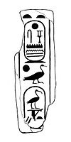
Brick with cartouches of pharaoh Djehuti, unearthed at Deir el-Ballas
Deir el-Ballas was excavated from 1900 to 1901 by a University of California team, sponsored by Phoebe A. Hearst and led by George Andrew Reisner [2][4] "These excavations uncovered a large royal palace, a settlement, and a series of cemeteries dating to the late Second Intermediate Period and the early Eighteenth Dynasty;" however, expedition records neither proved adequate enough for understanding [2][4] nor were compiled for publication. (The Ancient Egyptian Heritage and Archaeology Fund, however, received a three-year grant to accomplish this in 2016 from the Shelby White and Leon Levy Program for Archaeological Publications.[7][8] The excavated materials, housed in the Museum of Fine Arts, Boston, and the Phoebe A. Hearst Museum of the University of California in Berkley,[8] were studied, photographed and drawn, and these and Reisner's notes are as of January 2022 being collected into two volumes.[9] One is on the cemeteries at the site and the second is on the ancient settlement.[9])
"In order to clarify the records of the expedition and enable publication of the site, four seasons of survey and clearance were undertaken in 1980, 1983, 1984 and 1986 by Peter Lacovara under the sponsorship of the American Research Center and the Museum of Fine Arts, Boston."[2][4][10] Their findings "revealed a site far larger than the Hearst expedition records had indicated, including palace complexes, a group of large houses, and remains of a previously unrecorded ancient settlement."[2] "In addition to the large number of houses and other domestic structures, there appears to have been a group of memorial chapels similar to those recently excavated by The Egypt Exploration Society at Tell el-Amarna, and possibly an administrative quarter, also corresponding to Tell el-Amarna. At the conclusion of the survey seasons, a preliminary report was published under the auspices of the American Research Center in Egypt."[4][11]
According to Peter Lacovara, "In more recent years, the growth of the modern village and the construction of a number of roads along the desert edge, along with looting that occurred during the revolution in 2011 has threatened to destroy a significant part of the site."[4]
Lacovara and his team "were asked to come back to the site at the request of Mr. Mostafa Waziri and the Qena Inspectorate of Antiquities, because of their concern for the preservation and restoration of this important area."[10] For two weeks in January 2017, Lacovara led an expedition "consist[ing] of a theodolite survey, photography and planning to assess the condition of the site, the perimeter of the antiquities area and possible ways to protect and conserve the site."[14]
The team returned December 2018 through January 2019 for several restoration projects: replacing, cleaning and capping brick in the eastern facade of the South Palace's stair platform that had been dug out by looters;[14][9] restoring the same platform's original appearance by filling in its casemates and leveling out its top; [14][9] clean and refill the casemate foundations and restore the surviving walls of the North Palace;[14][9] remove trash and debris from both sites; and place fencing and signs in both Arabic and English around the dig sites to deter further damage.[14][9] "A surprising discovery made during the work [on the South Palace's stair platform] were a number of large ship timbers which had been re-used to strengthen the wall. These were undoubtedly recycled from the Theban fleet that had assembled at the site for the campaign against the Hyksos."[15] Unfortunately, they learned that "many of the ancient houses, the workmen’s village and associated chapels have been entirely destroyed by the expansion of modern habitation and the town’s cemetery."[15]
For the December 2019-January 2020 season, work on the above projects was continued.[16] The team also began work on restoring several houses, the southern part of the main enclosure wall of the North Palace, and the southwest corner of the casemate core of the North Palace.[16] One of these houses, dubbed House E, "The structure had been partially excavated and planned by the Hearst Expedition in 1900-1901 and was re-excavated by Cynthia Shartzer in 1985. One small section was exposed to floor level and was revealed to be a textile workshop in a remarkable state of preservation. A wooden beam that would have held a grasped spindle for making thread was found beside a column base, which had a socket cut into it to support the beam. Beside that was a limestone saddle-shaped bench for the weaver to sit on and a pottery spinning bowl...There was even a wool roving and woolen thread in the fill associated with the finds. At the north end of the section were two mud-brick bins, one of which still contained an upright post...While the elements had remained intact in House E, looters had dug a large hole through the center of the adjoining unexcavated room, although a great deal was left, including Egyptian pottery, fragments of Nubian Kerma ware and a Canaanite amphora."[16]
Because of the COVID-19 pandemic, work was not able to be resumed until, and only during, May 2021. A new project for the season was the excavation of two previously-untouched clusters near the South Palace: "In Area 2 was a very long, large building made up of a number of small rooms, and in Area 1 was a cluster of large and small structures extending over a broad area. This further supports our theory that this part of the site, like the Central City at Tell el-Amarna, was an administrative district. Moreover, the location of these structures at the mouth of a wadi running down to the river may signal that this was the location of the port for the settlement."[17]
Related Research Articles
Thebes, known to the ancient Egyptians as Waset, was an ancient Egyptian city located along the Nile about 800 kilometers (500 mi) south of the Mediterranean. Its ruins lie within the modern Egyptian city of Luxor. Thebes was the main city of the fourth Upper Egyptian nome and was the capital of Egypt for long periods during the Middle Kingdom and New Kingdom eras. It was close to Nubia and the Eastern Desert, with its valuable mineral resources and trade routes. It was a cult center and the most venerated city during many periods of ancient Egyptian history. The site of Thebes includes areas on both the eastern bank of the Nile, where the temples of Karnak and Luxor stand and where the city was situated; and the western bank, where a necropolis of large private and royal cemeteries and funerary complexes can be found. In 1979, the ruins of ancient Thebes were classified by UNESCO as a World Heritage Site.
Amarna is an extensive Egyptian archaeological site containing the remains of what was the capital city of the late Eighteenth Dynasty. The city was established in 1346 BC, built at the direction of the Pharaoh Akhenaten, and abandoned shortly after his death in 1332 BC. The name that the ancient Egyptians used for the city is transliterated as Akhetaten or Akhetaton, meaning "the horizon of the Aten".
Ahmose I was a pharaoh and founder of the Eighteenth Dynasty of Egypt, classified as the first dynasty of the New Kingdom of Egypt, the era in which ancient Egypt achieved the peak of its power. He was a member of the Theban royal house, the son of pharaoh Seqenenre Tao and brother of the last pharaoh of the Seventeenth dynasty, Kamose. During the reign of his father or grandfather, Thebes rebelled against the Hyksos, the rulers of Lower Egypt. When he was seven years old, his father was killed, and he was about ten when his brother died of unknown causes after reigning only three years. Ahmose I assumed the throne after the death of his brother, and upon coronation became known as Nebpehtyre, nb-pḥtj-rꜥ "The Lord of Strength is Ra".
Hyksos is a term which, in modern Egyptology, designates the kings of the Fifteenth Dynasty of Egypt. The seat of power of these kings was the city of Avaris in the Nile Delta, from where they ruled over Lower Egypt and Middle Egypt up to Cusae.
The history of ancient Egypt spans the period from the early prehistoric settlements of the northern Nile valley to the Roman conquest of Egypt in 39 BC. The pharaonic period, the period in which Egypt was ruled by a pharaoh, is dated from the 32nd century BC, when Upper and Lower Egypt were unified, until the country fell under Macedonian rule in 332 BC.
Amenhotep I or Amenophis I, was the second Pharaoh of the 18th Dynasty of Egypt. His reign is generally dated from 1526 to 1506 BC.
Dakhla Oasis, is one of the seven oases of Egypt's Western Desert. Dakhla Oasis lies in the New Valley Governorate, 350 km (220 mi.) from the Nile and between the oases of Farafra and Kharga. It measures approximately 80 km (50 mi) from east to west and 25 km (16 mi) from north to south.
Seqenenre Tao ruled over the last of the local kingdoms of the Theban region of Egypt in the Seventeenth Dynasty during the Second Intermediate Period. He probably was the son and successor to Senakhtenre Ahmose and Queen Tetisheri. The dates of his reign are uncertain, but he may have risen to power in the decade ending in 1560 BC or in 1558 BC. With his queen, Ahhotep I, Seqenenre Tao fathered two pharaohs, Kamose, his immediate successor who was the last pharaoh of the Seventeenth Dynasty, and Ahmose I who, following a regency by his mother, was the first pharaoh of the Eighteenth. Seqenenre Tao is credited with starting the opening moves in a war of revanchism against Hyksos incursions into Egypt, which saw the country completely liberated during the reign of his son Ahmose I.
The Seventeenth Dynasty of Egypt was a dynasty of pharaohs that ruled in Upper Egypt during the late Second Intermediate Period, approximately from 1580 to 1550 BC. Its mainly Theban rulers are contemporary with the Hyksos of the Fifteenth Dynasty and succeed the Sixteenth Dynasty, which was also based in Thebes.
The Valley of the Kings, also known as the Valley of the Gates of the Kings, is an area in Egypt where, for a period of nearly 500 years from the Eighteenth Dynasty to the Twentieth Dynasty, rock-cut tombs were excavated for pharaohs and powerful nobles under the New Kingdom of ancient Egypt.
The Small Aten Temple is a temple to the Aten located in the ancient Egyptian city of Amarna. It is one of the two major temples in the city, the other being the Great Temple of the Aten. It is situated next to the King's House and near the Royal Palace, in the central part of the city. Original known as the Hwt-Jtn or Mansion of the Aten, it was probably constructed before the larger Great Temple. Its only contemporary depiction is found in the tomb of Tutu. Like the other structures in the city, it was constructed quickly, and hence was easy to dismantle and reuse the material for later construction.
Seuserenre Khyan (also Khayan or Khian was a Hyksos king of the Fifteenth Dynasty of Egypt, ruling over Lower Egypt in the second half of the 17th century BCE. His royal name Seuserenre translates as "The one whom Re has caused to be strong." Khyan bears the titles of an Egyptian king, but also the title ruler of the foreign land. The later title is the typical designation of the Hyksos rulers.
The Hearst Papyrus, also called the Hearst Medical Papyrus, is one of the medical papyri of ancient Egypt. It was named after Phoebe Hearst. The papyrus contains 18 pages of medical prescriptions written in hieratic Egyptian writing, concentrating on treatments for problems dealing with the urinary system, blood, hair, and bites. It is dated to the first half of the 2nd millennium BC. It is considered an important manuscript, but some doubts persist about its authenticity.
Tell el-Dab'a is an archaeological site in the Nile Delta region of Egypt where Avaris, the capital city of the Hyksos, once stood. Avaris was occupied by Asiatics from the end of the 12th through the 13th Dynasty. The site is known primarily for its Minoan frescoes.
The use of urban planning in ancient Egypt is a matter of continuous debate. Because ancient sites usually survive only in fragments, and many ancient Egyptian cities have been continuously inhabited since their original forms, relatively little is actually understood about the general designs of Egyptian towns for any given period.
The Egyptologists Nina M. Davies and Norman de Garis Davies were a married couple of illustrators and copyists who worked in the early and mid-twentieth century drawing and recording paintings in Egypt. Their work was often published together, as N. de Garis Davies, and so it is usually difficult to determine who drew which illustration.
The following outline is provided as an overview of a topical guide to ancient Egypt:
The Eighteenth Dynasty of Egypt is classified as the first dynasty of the New Kingdom of Egypt, the era in which ancient Egypt achieved the peak of its power. The Eighteenth Dynasty spanned the period from 1550/1549 to 1292 BC. This dynasty is also known as the Thutmosid Dynasty for the four pharaohs named Thutmose.
Sekhemre Sementawy Djehuty was a minor king reigning over parts of Upper Egypt during the Second Intermediate Period.
Tel Habuwa is an archaeological site in Lower Egypt, located 3 kilometers from the Suez Canal in the Ismailia Governorate. It was suggested by scholars that this is the Ancient Egyptian Eastern-border city called Tjaru from the Middle Kingdom of Egypt.
↑ Christina Geisen, Zur zeitlichen Einordnung des Königs Djehuti an das Ende der 13. Dynastie, Studien zur Altägyptischen Kultur, Bd. 32, (2004), pp. 149-157
Richard A. Parker, Journal of the American Research Center in Egypt, Vol. 2, (1963), pp.113–116. Published by: American Research Center in Egypt.JSTOR40000975
Peter Lacovara, The New Kingdom Royal City, Routledge 2013. 256 pages. ISBN978-1-136-16817-8.
This page is based on this Wikipedia article Text is available under the CC BY-SA 4.0 license; additional terms may apply. Images, videos and audio are available under their respective licenses.