
The McCloud River is a 77.1-mile (124.1 km) long river that flows east of and parallel to the upper Sacramento River, in Siskiyou County and Shasta County in northern California in the United States. Protected under California's Wild and Scenic Rivers Act (1972), it drains a scenic mountainous area of the Cascade Range, including part of Mount Shasta. It is a tributary of the Pit River, which in turn flows into the Sacramento River. The three rivers join in Shasta Lake, formed by Shasta Dam north of Redding.
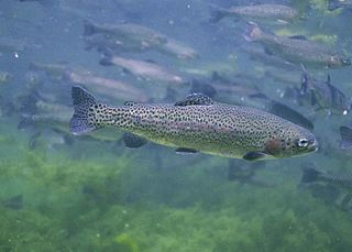
The rainbow trout is a species of trout native to cold-water tributaries of the Pacific Ocean in North America and Asia. The steelhead is an anadromous (sea-run) form of the coastal rainbow trout(O. m. irideus) or Columbia River redband trout (O. m. gairdneri) that usually returns to freshwater to spawn after living two to three years in the ocean. Freshwater forms that have been introduced into the Great Lakes and migrate into tributaries to spawn are also called steelhead.

The Californiagolden trout (Oncorhynchus aguabonita or Oncorhynchus mykiss aguabonita) is a species of trout native to California. The golden trout is normally found in the Golden Trout Creek, Volcano Creek, and the South Fork Kern River. The Golden trout is the official freshwater state fish of California since 1947.

Langford is a city on southern Vancouver Island in the province of British Columbia, Canada. Langford is one of the 13 component municipalities of Greater Victoria and is within the Capital Regional District. Langford was incorporated in 1992 and has a population of over 40,000 people. Its municipal neighbours are Colwood to the southeast, Highlands to the north, Metchosin to the southwest, and View Royal to the northeast.
Newfound Lake is located in Grafton County, New Hampshire, United States. It is situated in the Lakes Region of central New Hampshire, in the towns of Alexandria, Bridgewater, Bristol, and Hebron. Its area of 4,451 acres (18.0 km2) places it behind only Lake Winnipesaukee and Squam Lake among lakes located entirely within New Hampshire, and fourth in the state overall, when Umbagog Lake on the Maine border is included.

Houston is a forestry, mining and tourism town in the Bulkley Valley of the Northern Interior of British Columbia, Canada. Its population as of 2021 was 3,052, with approximately 2,000 in the surrounding rural area. It is known as the "steelhead capital" and it has the world's largest fly fishing rod. Houston's tourism industry is largely based on ecotourism and Steelhead Park, situated along Highway 16. Houston is named in honour of the pioneer newspaperman John Houston.
Jewel Lake Provincial Park is a provincial park bordering the northwestern end of Jewel Lake in the Boundary region of south central British Columbia. The park, via BC Highway 3 and Jewel Lake Rd, is about 14 kilometres (8.7 mi) northeast of Greenwood and 48 kilometres (30 mi) northwest of Grand Forks
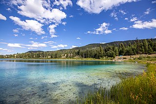
Kentucky Alleyne Provincial Park is a provincial park in British Columbia. The park is located 38 kilometres south of the city of Merritt, and east of the community of Aspen Grove. The park is named for two of its largest lakes, Kentucky Lake and Alleyne Lake. All lakes in the park have a distinctive turquoise colouration.
Norbury Lake Provincial Park is a 97-hectare (240-acre) provincial park in British Columbia, Canada.

Strathcona Provincial Park is the oldest provincial park in British Columbia, Canada, and the largest on Vancouver Island. Founded in 1911, the park was named for Donald Alexander Smith, 1st Baron Strathcona and Mount Royal, a wealthy philanthropist and railway pioneer. It lies within the Strathcona Regional District. The Clayoquot Sound Biosphere Reserve, established in 2000, includes three watersheds in the western area of the park.

Logan Lake is a district municipality in the Southern Interior of British Columbia, Canada.

Tulameen, originally known as Otter Flat, is a small community in British Columbia, Canada, about 26 kilometres northwest of the town of Princeton on the Crowsnest Highway, and about 185 kilometres northeast from the city of Vancouver, British Columbia. Located at the south end of Otter Lake and just north of the Tulameen River, it is on the lee side of the Canadian Cascades mountain range and enjoys a slightly semi-arid climate, sheltered from the heavy rains west of that range.

Mineral is an unincorporated community and census-designated place (CDP) in Lewis County, Washington, on State Route 7 near the Pierce/Lewis county line. Mineral originally began as a logging camp and mining town. Prospectors searching the area for gold instead found coal and arsenic. By the early 1920s, the mines closed, and with a devastating fire to the town's largest sawmill, Mineral began to turn to tourism as its main industry, primarily through recreational fishing on Mineral Lake. The population was 193 at the 2020 census, down from 202 at the 2010 census.

The Interlakes, also known as the Interlakes District, is a geographic region of the Interior of British Columbia, Canada, located along and around the Interlakes Highway between 100 Mile House on BC Highway 97 and Little Fort on the North Thompson River. The area is a subregion of the Cariboo and includes the communities of Bridge Lake and Lac des Roches.
Bridge Lake is a lake in the Interlakes District of the South Cariboo region of the Interior of British Columbia, Canada. It is the source of Bridge Creek which runs in a curving course west and then northeast to Canim Lake via the town of 100 Mile House. The lake is approximately 16 km2 in area (including the area of several islands and rocks in the lake, the largest of which is named Long Island and is 1136 m in elevation. It is located 560 km north of Vancouver and around 140 km northwest of Kamloops in the Interlakes District close to the Little Fort Highway. It and its neighbours Sheridan Lake and Lac des Roches are the largest lakes along the Interlakes Highway.
Black Canyon Lake is a lake in Navajo County, Arizona, United States.

Lake Ming is a man-made recreational lake located in Bakersfield, California. It is primarily a motorboat and water-skiing lake, although sailboats are allowed the second full weekend each month, and every Tuesday and Thursday after 1:30 pm. Lake Ming also has fishing and the Department of Fish and Game stocks the lake with 10 to 12 inches rainbow trout during the winter months. The primary fishes are Large-mouth Bass, Catfish, Crappie, Bluegill, Carp and stocked Rainbow Trout. Lake Ming is a part of the Kern River County Park. The National Jet Boat Association holds races at the lake throughout the year.

Sulphurous Lake is a freshwater body in the Cariboo Region of British Columbia, generally considered to be part of the Interlakes area as it is near Deka Lake. The lake has only one boat launch, which is now listed as an official recreation site.

Eastgate is a small cabin community located at the Eastern portal of Manning Provincial Park in the Cascade Mountains of British Columbia, Canada. It is located in the Similkameen-Okanagan Forest District. The community store and gas station, and formerly the now closed restaurant, are popular for visitors of Manning Park Resort and ski area. The settlement is located along the uppermost Similkameen River. Access to Eastgate is limited solely to east–west travel along the Hope-Princeton Highway. The community has one gas station, a Canco gas station, a cabin rental and a bed and breakfast. The gas station was formerly host to the Eastgate Canada Post Office. The Eastgate Volunteer Fire Department, with three trucks, provides fire protection for the area and frequently participates in forest fire control in the region. The small town shows up on some government maps as Manning Park.
