Del Monte Forest, California

Last updated

Del Monte Forest
Monterey County California Incorporated and Unincorporated areas Del Monte Forest Highlighted.svg
Location in Monterey County and the state of California
Location map Monterey Peninsula.png
Red pog.svg
Del Monte Forest
Location in the United States
Coordinates: 36°35′11″N121°56′51″W / 36.58639°N 121.94750°W / 36.58639; -121.94750
Country Flag of the United States.svg  United States
State Flag of California.svg  California
County Monterey
Government
   State senator John Laird (D) [1]
   Assemblymember Robert Rivas (D) [1]
   U. S. rep. Jimmy Panetta (D) [2]
Area
[3]
  Total10.64 sq mi (27.55 km2)
  Land8.03 sq mi (20.79 km2)
  Water2.61 sq mi (6.77 km2)  24.54%
Elevation
[4]
207 ft (63 m)
Population
 (2020) [5]
  Total4,204
  Density523.80/sq mi (202.23/km2)
Time zone UTC-8 (PST)
  Summer (DST) UTC-7 (PDT)
ZIP code
93953 (Pebble Beach)
Area code 831
FIPS code 06-18590
GNIS feature ID 1867013

Del Monte Forest (Del Monte, Spanish for "of the mountain") is a census-designated place (CDP) in Monterey County, California, United States. As of the 2020 census, the CDP had a total population of 4,204, [5] down from 4,514 at the 2010 census. The census area includes the separate well-known community of Pebble Beach.

Contents

The Del Monte Forest is a habitat area of the same location, which originally occupied considerably more area prior to urban development of the 20th century. The forest is dominated by Monterey pine, but also contains other important tree species and a variety of rare and endangered plant species.

Geography and ecology

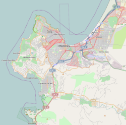
Del Monte Forest is located in northwestern Monterey County at 36°35'11" North, 121°56'51" West. [4] It occupies the western half of the Monterey Peninsula and is bordered to the east by the city of Montery and to the north by the city of Pacific Grove. The city of Carmel-by-the-Sea is to the south. Pebble Beach is in the southern part of the CDP.

According to the United States Census Bureau, Del Monte Forest has a total area of 10.6 square miles (27 km2), of which 8.0 square miles (21 km2) are land and 2.6 square miles (6.7 km2) are water. The total area is 24.55% water. [3]

The community is a habitat for a number of limited range and endangered species.

History

The Del Monte Forest was originally part of the resort complex of the Hotel Del Monte in Monterey. The resort hotel was built by Charles Crocker, one of California's Big Four railroad barons, through Southern Pacific Railroad's property division, the Pacific Improvement Company (PIC). [6] The hotel first opened on June 10, 1880. [6] Samuel Finley Brown Morse formed the Del Monte Properties Company on February 27, 1919, and acquired the extensive holdings of the PIC, which included the Del Monte Forest, the Del Monte Lodge (since renamed the Lodge at Pebble Beach) and the Hotel Del Monte. [7] The actual hotel building and surrounding grounds were acquired by the United States Navy after World War II to be the Navy's new location of the Naval Postgraduate School.

Demographics

Historical population
CensusPop.Note
2000 4,532
2010 4,514−0.4%
2020 4,204−6.9%
U.S. Decennial Census [8]

2010

The 2010 United States Census [9] reported that Del Monte Forest had a population of 4,514. The population density was 424.0 inhabitants per square mile (163.7/km2). The racial makeup of Del Monte Forest was 3,922 (86.9%) White, 43 (1.0%) African American, 10 (0.2%) Native American, 388 (8.6%) Asian, 3 (0.1%) Pacific Islander, 57 (1.3%) from other races, and 91 (2.0%) from two or more races. Hispanic or Latino of any race were 167 persons (3.7%).

The Census reported that 4,172 people (92.4% of the population) lived in households, 321 (7.1%) lived in non-institutionalized group quarters, and 21 (0.5%) were institutionalized.

There were 1,925 households, out of which 309 (16.1%) had children under the age of 18 living in them, 1,215 (63.1%) were opposite-sex married couples living together, 96 (5.0%) had a female householder with no husband present, 41 (2.1%) had a male householder with no wife present. There were 45 (2.3%) unmarried opposite-sex partnerships, and 18 (0.9%) same-sex married couples or partnerships. 468 households (24.3%) were made up of individuals, and 310 (16.1%) had someone living alone who was 65 years of age or older. The average household size was 2.17. There were 1,352 families (70.2% of all households); the average family size was 2.53.

The population was spread out, with 748 people (16.6%) under the age of 18, 213 people (4.7%) aged 18 to 24, 541 people (12.0%) aged 25 to 44, 1,449 people (32.1%) aged 45 to 64, and 1,563 people (34.6%) who were 65 years of age or older. The median age was 57.8 years. For every 100 females, there were 92.6 males. For every 100 females age 18 and over, there were 90.0 males.

There were 2,811 housing units at an average density of 264.0 per square mile (101.9/km2), of which 1,600 (83.1%) were owner-occupied, and 325 (16.9%) were occupied by renters. The homeowner vacancy rate was 4.0%; the rental vacancy rate was 5.4%. 3,372 people (74.7% of the population) lived in owner-occupied housing units and 800 people (17.7%) lived in rental housing units.

2000

As of the census [10] of 2000, there were 4,531 people, 2,092 households, and 1,456 families residing in the CDP. The population density was 565.4 inhabitants per square mile (218.3/km2). There were 2,647 housing units at an average density of 330.3 per square mile (127.5/km2). The racial makeup of the CDP was 91.37% White, 0.40% African American, 0.26% Native American, 5.25% Asian, 0.18% Pacific Islander, 0.88% from other races, and 1.66% from two or more races. 2.34% of the population were Hispanic or Latino of any race.

There were 2,092 households, out of which 14.9% had children under the age of 18 living with them, 63.7% were married couples living together, 4.7% had a female householder with no husband present, and 30.4% were non-families. 24.8% of all households were made up of individuals, and 16.9% had someone living alone who was 65 years of age or older. The average household size was 2.17 and the average family size was 2.52.

The age distribution was 12.8% under the age of 18, 3.1% from 18 to 24, 12.6% from 25 to 44, 35.6% from 45 to 64, and 35.9% who were 65 years of age or older. The median age was 57 years. For every 100 females, there were 86.7 males. For every 100 females age 18 and over, there were 85.4 males.

The median income for a household in the CDP was $99,788, and the median income for a family was $112,741. Males had a median income of $79,431 versus $44,707 for females. The per capita income for the CDP was $70,609. 2.3% of the population and 1.8% of families were below the poverty line. Out of the total population, 4.2% of those under the age of 18 and 2.5% of those 65 and older were living below the poverty line.

Government

At the county level, Del Monte Forest is represented on the Monterey County Board of Supervisors by Supervisor Dave Potter. [11]

In the California State Legislature, Del Monte Forest is in the 17th Senate District , represented by Democrat John Laird, and in the 29th Assembly District , represented by Democrat Robert Rivas. [1]

In the United States House of Representatives, Del Monte Forest is in California's 19th congressional district , represented by Democrat Jimmy Panetta. [2]

Environmental features

The Monterey Pine forest is habitat to numerous rare and endangered species including Hickman's potentilla and Yadon's piperia, both of which are federally protected species. [12]

See also

Related Research Articles

<span class="mw-page-title-main">Del Rey, California</span> Census-designated place in California, United States

Del Rey is a census-designated place (CDP) in Fresno County, California, United States. The population was 1,639 at the 2010 census, up from 950 at the 2000 census. Del Rey is located 3.5 miles (5.6 km) south-southwest of Sanger, at an elevation of 344.

<span class="mw-page-title-main">North El Monte, California</span> Census-designated place in California, United States

North El Monte is a census-designated place (CDP) in the San Gabriel Valley, in Los Angeles County, California, United States. The population was 3,723 at the 2010 census, up from 3,703 at the 2000 census.

<span class="mw-page-title-main">Aromas, California</span> Census-designated place in California, United States

Aromas is an unincorporated community and census-designated place (CDP) in Monterey County and San Benito County, California, United States. The population was 2,708 at the 2020 census.

<span class="mw-page-title-main">Boronda, California</span> Census-designated place in California, United States

Boronda is an unincorporated community and census-designated place (CDP) in Monterey County, California, United States. The population was 1,760 at the 2020 census. Boronda is located directly west of Salinas and is named after José Eusebio Boronda, a Californio ranchero, and located on the lands of his Rancho Rincón del Sanjón.

<span class="mw-page-title-main">Bradley, California</span> Unincorporated community in California, United States

Bradley is an unincorporated community and census-designated place (CDP) in Monterey County, California, on the Salinas River 14 miles (23 km) south-southeast of San Ardo and 20 miles (32 km) north of Paso Robles. Bradley sits at an elevation of 548 feet (167 m). The population was 69 at the 2020 census, down from 93 at the 2010 census.

<span class="mw-page-title-main">Castroville, California</span> Unincorporated community in California, United States

Castroville is an unincorporated town and census-designated place (CDP) in Monterey County, California, United States. At the time of the 2020 census the population was 7,515, up from 6,481 in 2010. Castroville is known for its artichoke crop and for the annual Castroville Artichoke Festival, leading to its nickname as the "Artichoke Center of the World".

<span class="mw-page-title-main">Chualar, California</span> Unincorporated community in California, United States

Chualar is an unincorporated community and census-designated place (CDP) in the Salinas Valley of Monterey County, California, United States. Chualar is located 10 miles (16 km) southeast of Salinas, at an elevation of 115 feet (35 m). The population was 1,185 at the 2020 census.

<span class="mw-page-title-main">Del Rey Oaks, California</span> City in California, United States

Del Rey Oaks is a city in Monterey County, California, United States. It is located just southeast of Seaside, at an elevation of 82 feet (25 m). The population was 1,592 at the 2020 census. Del Rey Oaks is a member of the Association of Monterey Bay Area Governments, a regional government agency.

<span class="mw-page-title-main">Elkhorn, California</span> Census-designated place in California, United States

Elkhorn is an unincorporated community and census-designated place (CDP) in Monterey County, California, United States.

<span class="mw-page-title-main">Las Lomas, California</span> Census-designated place in California, United States

Las Lomas is an unincorporated community and census-designated place (CDP) in Monterey County, California, United States. Las Lomas is located 7 miles (11 km) north-northwest of Prunedale. The elevation is 43 feet (13 m). The population was 3,046 at the 2020 census.

<span class="mw-page-title-main">Moss Landing, California</span> Census designated place in California, United States

Moss Landing, formerly Moss, is an unincorporated community and census-designated place (CDP) in Monterey County, California, United States. It is located 18 miles (29 km) north-northeast of Monterey, at an elevation of 10 feet (3.048 m). It is on the shore of Monterey Bay, at the mouth of Elkhorn Slough and at the head of the submarine Monterey Canyon.

<span class="mw-page-title-main">Pajaro, California</span> Census designated place in California, United States

Pajaro is an unincorporated community and census-designated place (CDP) in Monterey County, California. It is located on the south bank of the Pajaro River 5 miles (8 km) northeast of its mouth, at an elevation of 26 feet (7.9 m). The population was 2,882 at the 2020 census, down from 3,070 in 2010. The school district is in Santa Cruz County.

<span class="mw-page-title-main">Prunedale, California</span> Census-designated place in California, United States

Prunedale is a census-designated place in Monterey County, California, United States. It is located 8 miles (13 km) north of Salinas at an elevation of 92 feet (28 m). The population was 18,885 as of the 2020 census, up from 17,560 in 2010. Plum trees were grown in Prunedale in the early days of its founding, but the trees died soon after due to poor irrigation and fertilizer.

<span class="mw-page-title-main">San Ardo, California</span> Unincorporated community in California, United States

San Ardo, formerly known as San Bernardo, is an unincorporated community and census-designated place (CDP) in Monterey County, California, United States. San Ardo is located 18 miles (29 km) southeast of King City at an elevation of 449 feet (137 m). The population was 392 at the 2020 census, down from 517 in 2010.

<span class="mw-page-title-main">San Lucas, California</span> Census-designated place in California, United States

San Lucas is an unincorporated community and census-designated place (CDP) in Monterey County, California, United States. It was founded in 1886 and named after the Rancho San Lucas, which was granted in 1842. The post office was first established in 1892.

<span class="mw-page-title-main">Spreckels, California</span> Unincorporated community in California, United States

Spreckels is an unincorporated community and census-designated place (CDP) in the Salinas Valley of Monterey County, California, United States. Spreckels is located 3 miles (5 km) south of Salinas, at an elevation of 62 ft (19 m). Its population was 692 at the 2020 census.

<span class="mw-page-title-main">Rio del Mar, California</span> Census-designated Place in California, United States

Rio del Mar is an unincorporated village in Santa Cruz County, California. Rio del Mar is one of several small villages that form the unincorporated community of Aptos, California. Its population was 9,128 as of the 2020 United States census.

<span class="mw-page-title-main">Monte Rio, California</span> Census-designated place in California, United States

Monte Rio is a census-designated place (CDP) in Sonoma County, California along the Russian River near the Pacific Ocean. The town of Guerneville lies northeast of Monte Rio, and Jenner is to the west. The population was 1,152 at the 2010 census, up from 1,104 at the 2000 census. Bohemian Grove is located in Monte Rio.

<span class="mw-page-title-main">Mira Monte, California</span> Rural community in Ventura County, California, United States

Mira Monte is a rural community in Ventura County, California, United States. Mira Monte is located in between the communities of Oak View, Meiners Oaks, and southwest of the City of Ojai, California. For statistical purposes, the United States Census Bureau has defined Mira Monte as a census-designated place (CDP). The census definition of the area may not precisely correspond to local understanding of the area with the same name. According to the 2020 census, the population of Mira Monte is 6,618, down from 6,845 at the 2010 census.

<span class="mw-page-title-main">Carmel Valley Village, California</span> Unincorporated community in California, United States

Carmel Valley Village is an unincorporated community and census-designated place (CDP) in Monterey County, California, United States. In 1946, Byington Ford and Tirey L. Ford Jr. developed the Carmel Valley Village, which included an airpark, shops, and homes. At the time of the 2020 census the CDP population was 4,524, up from 4,407 at the 2010 census. In November 2009, a majority of residents voted against incorporation.

References

  1. 1 2 3 "Statewide Database". UC Regents. Retrieved February 2, 2015.
  2. 1 2 "California's 19th Congressional District - Representatives & District Map". Civic Impulse, LLC.
  3. 1 2 "2022 U.S. Gazetteer Files: California". United States Census Bureau. Retrieved November 18, 2022.
  4. 1 2 U.S. Geological Survey Geographic Names Information System: Del Monte Forest, California
  5. 1 2 "P1. Race – Del Monte Forest CDP, California: 2020 DEC Redistricting Data (PL 94-171)". U.S. Census Bureau. Retrieved November 18, 2022.
  6. 1 2 Hathaway, Pat. "Hotel Del Monte, Monterey". California Views: The Pat Hathaway Photo Collection. Retrieved June 22, 2013.
  7. Pebble Beach Company History Archived 2010-07-23 at the Wayback Machine
  8. "Census of Population and Housing". Census.gov. Retrieved June 4, 2016.
  9. "2010 Census Interactive Population Search: CA - Del Monte Forest CDP". U.S. Census Bureau. Archived from the original on July 15, 2014. Retrieved July 12, 2014.
  10. "U.S. Census website". United States Census Bureau . Retrieved January 31, 2008.
  11. "Monterey County Supervisorial District 5 Map (North District 5)" (PDF). County of Monterey. Archived from the original (PDF) on July 1, 2012. Retrieved September 21, 2012.
  12. C. Michael Hogan and Michael P. Frankis. 2009. Monterey Cypress: Cupressus macrocarpa, GlobalTwitcher.com ed. N. Stromberg Archived 2017-09-06 at the Wayback Machine