Delaware, Oklahoma

Last updated

Delaware, Oklahoma
OKMap-doton-Delaware.PNG
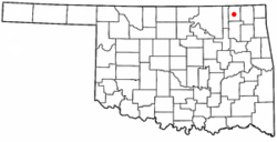
Location of Delaware, Oklahoma
Coordinates: 36°46′44″N95°38′33″W / 36.77889°N 95.64250°W / 36.77889; -95.64250
Country United States
State Oklahoma
County Nowata
Area
[1]
  Total0.39 sq mi (1.02 km2)
  Land0.39 sq mi (1.02 km2)
  Water0.00 sq mi (0.00 km2)
Elevation
[2]
715 ft (218 m)
Population
 (2020)
  Total267
  Density677.66/sq mi (261.74/km2)
Time zone UTC-6 (Central (CST))
  Summer (DST) UTC-5 (CDT)
ZIP code
74027
Area code(s) 539/918
FIPS code 40-19850 [3]
GNIS feature ID2412417 [2]

Delaware is a town in Nowata County, Oklahoma, United States. The population was 267 at the 2020 census, a decline of 35.9 percent from the figure of 417 recorded in 2010. [4] The town is named for the Eastern Delaware tribe that moved into this area from Kansas after signing a treaty with the Cherokee Nation in 1867. [5]

Contents

History

In 1889, the Kansas and Arkansas Valley Railroad built a line through this area. It constructed a switch at the present townsite, which it named Comana Switch. A small community sprung up here, which soon became known as Delaware. The name became permanent when a post office was established by that name on March 19, 1898. [5]

Discovery of oil nearby in 1904 briefly turned Delaware into a boom town with four thousand residents. However, the bubble burst and the population quickly fell to 108 by November 1907. The population has fluctuated since then, though generally declining from an official high of 804 in 1920. [5]

Geography

Delaware is on rolling prairie just west of the Verdigris River. [5]

According to the United States Census Bureau, the town has a total area of 0.4 square miles (1.0 km2), all land.

Demographics

Historical population
CensusPop.Note
1910 662
1920 80421.5%
1930 526−34.6%
1940 5423.0%
1950 5827.4%
1960 540−7.2%
1970 534−1.1%
1980 5441.9%
1990 434−20.2%
2000 4565.1%
2010 417−8.6%
2020 267−36.0%
U.S. Decennial Census [6]

As of the census [3] of 2000, there were 456 people, 171 households, and 129 families residing in the town. The population density was 1,209.6 inhabitants per square mile (467.0/km2). There were 194 housing units at an average density of 514.6 per square mile (198.7/km2). The racial makeup of the town was 73.25% White, 21.93% Native American, 0.44% from other races, and 4.39% from two or more races. Hispanic or Latino of any race were 0.66% of the population.

There were 171 households, out of which 36.8% had children under the age of 18 living with them, 60.2% were married couples living together, 9.9% had a female householder with no husband present, and 24.0% were non-families. 20.5% of all households were made up of individuals, and 9.9% had someone living alone who was 65 years of age or older. The average household size was 2.67 and the average family size was 3.05.

In the town, the population was spread out, with 28.1% under the age of 18, 11.0% from 18 to 24, 27.9% from 25 to 44, 20.6% from 45 to 64, and 12.5% who were 65 years of age or older. The median age was 36 years. For every 100 females, there were 109.2 males. For every 100 females age 18 and over, there were 97.6 males.

The median income for a household in the town was $28,167, and the median income for a family was $31,071. Males had a median income of $27,917 versus $18,125 for females. The per capita income for the town was $11,099. About 9.7% of families and 18.5% of the population were below the poverty line, including 20.7% of those under age 18 and 22.7% of those age 65 or over.

Related Research Articles

<span class="mw-page-title-main">Chesterfield, Indiana</span> Town in Indiana, United States

Chesterfield is a town in the U.S. state of Indiana which lies in Union Township, Madison County, and Salem Township, Delaware County. The population was 2,490 at the 2020 census. It is part of the Indianapolis–Carmel–Anderson metropolitan statistical area.

<span class="mw-page-title-main">Delaware, Iowa</span> City in Iowa, United States

Delaware is a city in Delaware County, Iowa, United States. The population was 142 at the time of the 2020 census.

<span class="mw-page-title-main">Baker, Missouri</span> Village in Missouri, United States

Baker is an inactive incorporated village in Stoddard County, Missouri, United States. Per the 2020 census, the population was 3. As of 2017, it is Missouri's smallest incorporated settlement.

Cayuga Springs is an unincorporated community and census-designated place (CDP) in Delaware County, Oklahoma, United States. The population was 140 at the 2010 census, a 33.3 percent increase over the figure of 105 recorded in 2000.

Copeland is an unincorporated community and census-designated place (CDP) in Delaware County, Oklahoma, United States. The population was 1,629 at the 2010 census, a 12.5 percent increase from the figure of 1,448 recorded in 2000. Founded as a railroad community, it was named for local resident D.R. Copeland.

<span class="mw-page-title-main">Dennis, Oklahoma</span> Census-designated place in Oklahoma, United States

Dennis is an unincorporated community and census-designated place (CDP) in Delaware County, Oklahoma, near Grand Lake. The population was 195 at the 2010 census. The Dennis Post Office existed from March 25, 1914, until January 31, 1956. It is said to be named for a local resident, Peter Dennis.

Dripping Springs is an unincorporated community and census-designated place (CDP) in Delaware County, Oklahoma, United States. The population was 50 at the 2010 census, up from the figure of 41 recorded in 2000.

Flint Creek is an unincorporated area and census-designated place (CDP) in Delaware County, Oklahoma, United States. The population was 732 at the 2010 census, up from 580 in 2000.

<span class="mw-page-title-main">Kansas, Oklahoma</span> Town in Oklahoma, United States

Kansas is a town in Delaware County, Oklahoma, United States. The population was 802 at the 2010 census.

Rocky Ford is a census-designated place (CDP) in Delaware and Cherokee counties, Oklahoma, United States. The population was 61 at the 2010 census.

Sycamore is a census-designated place (CDP) in Delaware County, Oklahoma, United States. The population was 177 at the 2010 census.

Tagg Flats is a census-designated place (CDP) in Delaware County, Oklahoma, United States. The population was 13 at the 2010 census.

<span class="mw-page-title-main">Twin Oaks, Oklahoma</span> Census-designated place in Oklahoma, United States

Twin Oaks is an unincorporated community and census-designated place (CDP) in Delaware County, Oklahoma, United States. The population was 198 at the 2010 census. A tornado hit the town on March 12, 2006, destroying 36 homes and damaging 31 others. 8 people were injured.

<span class="mw-page-title-main">West Siloam Springs, Oklahoma</span> Town in Oklahoma, United States

West Siloam Springs is a town in Delaware County, Oklahoma, United States. The population was 1,000 at the 2020 census, an 18.2 percent increase from the figure of 846 recorded in 2010. A bedroom community for Siloam Springs, Arkansas, it is notable for its Cherokee casino, and is the closest town to Natural Falls State Park.

<span class="mw-page-title-main">Kremlin, Oklahoma</span> Town in Oklahoma, United States

Kremlin is a town in Garfield County, Oklahoma, United States. The population was 255 at the 2010 census, a 6.25 percent increase from the figure of 240 in 2000.

<span class="mw-page-title-main">Wapanucka, Oklahoma</span> Town in Oklahoma, United States

Wapanucka is a town in northeastern Johnston County, Oklahoma, United States. The population was 438 at the 2010 census, a 1.6 percent decrease from the figure of 445 in 2000. It is about 20 miles (32 km) northeast of Tishomingo. The town name refers to the Delaware Nation and means "Eastern Land People."

<span class="mw-page-title-main">Davenport, Oklahoma</span> Town in Oklahoma, United States

Davenport is a town in Lincoln County, Oklahoma, United States. The population was 814 at the 2010 census.

<span class="mw-page-title-main">Lenapah, Oklahoma</span> Town in Oklahoma, United States

Lenapah is a town in north central Nowata County, Oklahoma, United States, eleven miles north of Nowata and sixty two miles northeast of Tulsa. Its name is an adaptation of Lenape, the name of a Delaware Tribe of Indians. The population was 293 at the 2010 census, a 1.7 percent decrease from the figure of 298 recorded in 2000.

<span class="mw-page-title-main">Wann, Oklahoma</span> Town in Oklahoma, United States

Wann is a town in Nowata County, Oklahoma, United States. The population was 125 at the 2010 census, a decrease of 5.3 percent from the figure of 132 recorded in 2000. Wann is known for the "Six Flag Poles Over Wann America.

<span class="mw-page-title-main">Forest Park, Oklahoma</span> Town in Oklahoma, United States

Forest Park is a town in Oklahoma County, Oklahoma, United States, and a part of the Oklahoma City metropolitan area. The population was 998 at the 2010 census.

References

  1. "ArcGIS REST Services Directory". United States Census Bureau. Retrieved September 20, 2022.
  2. 1 2 U.S. Geological Survey Geographic Names Information System: Delaware, Oklahoma
  3. 1 2 "U.S. Census website". United States Census Bureau . Retrieved January 31, 2008.
  4. MuniNet Guide: Delaware, Oklahoma Archived August 13, 2014, at the Wayback Machine
  5. 1 2 3 4 Cheatham, Gary L. Encyclopedia of Oklahoma History and Culture "Delaware." Archived December 30, 2008, at the Wayback Machine
  6. "Census of Population and Housing". Census.gov. Retrieved June 4, 2015.